cane5 wrote:tropicwatch wrote:Kind of weird. NOAA does one low altitude pass through the center then does the rest of the mission around 24000 ft. It has done this on two missions today.
so what does that tell you ?
Checking the other levels.
Moderator: S2k Moderators


cane5 wrote:tropicwatch wrote:Kind of weird. NOAA does one low altitude pass through the center then does the rest of the mission around 24000 ft. It has done this on two missions today.
so what does that tell you ?

Nuno wrote:eastcoastFL wrote:jlauderdal wrote:I think tomorrow there will be shutters, you are closer to anticipated landfall than me, I expect shutters to appear here tomorrow.
Landfall is about 2 miles south of me. But I'm debating shutters. I don't think I've put shutters up for a cat1. Is it necessary?
Most insurance policies can decline to cover you if you don't put up shutters but have them down and take on damage.

cane5 wrote:eastcoastFL wrote:cane5 wrote:To me the logic for a landfall near Miami all hinges on how much of a southwest turn she makes. It’s still a unknown. Remember for 48 hours all we heard was landfall in Tampa hundreds of thousands evacuated all to end up being a Fort Meyers/Naples event. Don’t drink the koolade just yet. !!
That would be quite a swing in track 48 hours out.
Just look at what Ian did but aside from that the storm is still projected to curve southwest a 20 mile jog almost changes everything and we are not there yet. Mark this post the gulfstream has a mind of its own even once it makes that dip.
cane5 wrote:tropicwatch wrote:Kind of weird. NOAA does one low altitude pass through the center then does the rest of the mission around 24000 ft. It has done this on two missions today.
so what does that tell you ?
eastcoastFL wrote:cane5 wrote:eastcoastFL wrote:
That would be quite a swing in track 48 hours out.
Just look at what Ian did but aside from that the storm is still projected to curve southwest a 20 mile jog almost changes everything and we are not there yet. Mark this post the gulfstream has a mind of its own even once it makes that dip.
Anything is possible that’s for sure. Right now though miami is about 100 miles south of the NHC track.

jfk08c wrote:cane5 wrote:tropicwatch wrote:Kind of weird. NOAA does one low altitude pass through the center then does the rest of the mission around 24000 ft. It has done this on two missions today.
so what does that tell you ?
Subtropical systems develop differently than a tropical system. Usually starts from the top atmospheric levels and works downward


cane5 wrote:eastcoastFL wrote:cane5 wrote:
Just look at what Ian did but aside from that the storm is still projected to curve southwest a 20 mile jog almost changes everything and we are not there yet. Mark this post the gulfstream has a mind of its own even once it makes that dip.
Anything is possible that’s for sure. Right now though miami is about 100 miles south of the NHC track.
Hallandale is 2 minutes from Miami and they are under a Hurricane watch. It hasn’t even developed yet and models were off 100 miles with Ian. Anyway I live in Miami I know about storms that are under a choking high pressure ridge and in the Gulfstream. My hope is we lose power for a day and impacts are minimal.
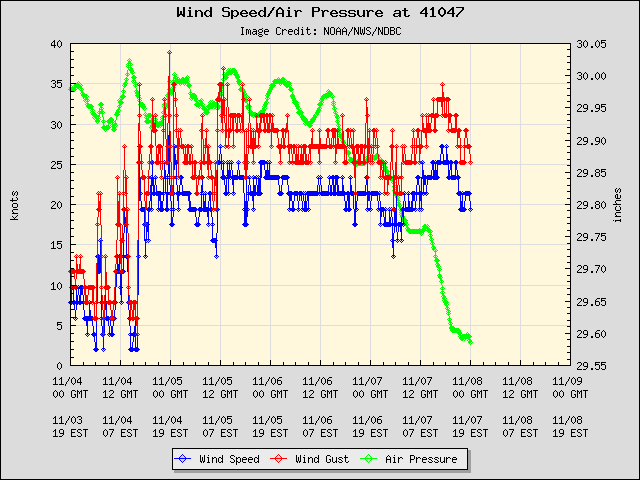
gatorcane wrote:Here is the observation data for a buoy a little NW of the storm. Notable pressure drop and winds on the increase:

psyclone wrote:I wonder if maybe they go ahead with a ts warning at 10 PM on the east coast and leave the hurricane watch as is to see how the storm behaves. Gales look to be a lock for a long time for sure. What a beach wrecker with full moon tides. Might see some ts watches on the gulf coast too...maybe Englewood up to suwannee river as a WAG..
psyclone wrote:I wonder if maybe they go ahead with a ts warning at 10 PM on the east coast and leave the hurricane watch as is to see how the storm behaves. Gales look to be a lock for a long time for sure. What a beach wrecker with full moon tides. Might see some ts watches on the gulf coast too...maybe Englewood up to suwannee river as a WAG..

eastcoastFL wrote:psyclone wrote:I wonder if maybe they go ahead with a ts warning at 10 PM on the east coast and leave the hurricane watch as is to see how the storm behaves. Gales look to be a lock for a long time for sure. What a beach wrecker with full moon tides. Might see some ts watches on the gulf coast too...maybe Englewood up to suwannee river as a WAG..
They already have a TS warning and hurricane watch up together here. We are currently under both in Martin county.
Users browsing this forum: No registered users and 8 guests


