https://twitter.com/tylerjstanfield/status/1575482601271599104
Julia could be our next major. Very weird it’s happening this late given both GFS and EURO have shown development of this wave, with both making it a hurricane. Probably 0/20 at 2pm given the uptick.
Tropical Wave South of the Cape Verde Islands (Is invest 92L)
Moderator: S2k Moderators
Forum rules

The posts in this forum are NOT official forecasts and should not be used as such. They are just the opinion of the poster and may or may not be backed by sound meteorological data. They are NOT endorsed by any professional institution or STORM2K. For official information, please refer to products from the National Hurricane Center and National Weather Service.
-
MarioProtVI
- Category 5

- Posts: 1039
- Age: 24
- Joined: Sun Sep 29, 2019 7:33 pm
- Location: New Jersey
-
weeniepatrol

- Category 5
- Posts: 1345
- Joined: Sat Aug 22, 2020 5:30 pm
- Location: WA State
Re: Tropical Wave SE of the Cape Verde Islands
GFS Ensemble Members 9/29 12Z Forecast for the next seven days:

WNW to NW motion
WNW to NW motion
4 likes
-
cycloneye

- Admin

- Posts: 149727
- Age: 69
- Joined: Thu Oct 10, 2002 10:54 am
- Location: San Juan, Puerto Rico
Re: Tropical Wave SE of the Cape Verde Islands
Abdullah wrote:GFS Ensemble Members 9/29 12Z Forecast for the next seven days:
https://i.imgur.com/1fspSJ3.gif
WNW to NW motion
I am watching those ahead.
3 likes
Visit the Caribbean-Central America Weather Thread where you can find at first post web cams,radars
and observations from Caribbean basin members Click Here
and observations from Caribbean basin members Click Here
-
weeniepatrol
- Category 5
- Posts: 1345
- Joined: Sat Aug 22, 2020 5:30 pm
- Location: WA State
Re: Tropical Wave SE of the Cape Verde Islands
1. Eastern Tropical Atlantic:
A tropical wave moving off the west coast of Africa is producing a
broad area of showers and thunderstorms. Environmental conditions
appear generally conducive for gradual development of this system
through early next week as it moves westward to west-northwestward
into the eastern tropical Atlantic.
* Formation chance through 48 hours...low...near 0 percent.
* Formation chance through 5 days...low...30 percent.
3 likes
-
galaxy401

- Category 5
- Posts: 2446
- Age: 30
- Joined: Sat Aug 25, 2012 9:04 pm
- Location: Casa Grande, Arizona
Re: Tropical Wave SE of the Cape Verde Islands
Usually at this point, the door closes for the Cape Verde region. But with how backloaded this season is, I figure that region will still be active.
6 likes
Got my eyes on moving right into Hurricane Alley: Florida.

Re: Tropical Wave SE of the Cape Verde Islands
That's a pretty weird track...
4 likes
TC naming lists: retirements and intensity
Most aggressive Advisory #1's in North Atlantic (cr. kevin for starting the list)
Most aggressive Advisory #1's in North Atlantic (cr. kevin for starting the list)
-
Category5Kaiju

- Category 5
- Posts: 4347
- Joined: Thu Dec 24, 2020 12:45 pm
- Location: Seattle during the summer, Phoenix during the winter
Re: Tropical Wave SE of the Cape Verde Islands
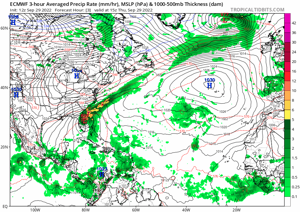
Teban54 wrote:That's a pretty weird track...
https://i.postimg.cc/m2p5mVB7/ecmwf-mslp-pcpn-atl-fh3-240.gif
Kind of like what Irma did....except in October
4 likes
Unless explicitly stated, all information in my posts is based on my own opinions and observations. Tropical storms and hurricanes can be extremely dangerous. Refer to an accredited weather research agency or meteorologist if you need to make serious decisions regarding an approaching storm.

Re: Tropical Wave SE of the Cape Verde Islands
Typical model biases are in full effect here. The GFS has this AOI recurve very early and impact the Cape Verde islands, while the CMC and Euro get it a lot further west before recurving.
4 likes
Irene '11 Sandy '12 Hermine '16 5/15/2018 Derecho Fay '20 Isaias '20 Elsa '21 Henri '21 Ida '21
I am only a meteorology enthusiast who knows a decent amount about tropical cyclones. Look to the professional mets, the NHC, or your local weather office for the best information.
I am only a meteorology enthusiast who knows a decent amount about tropical cyclones. Look to the professional mets, the NHC, or your local weather office for the best information.
Re: Tropical Wave SE of the Cape Verde Islands
aspen wrote:Typical model biases are in full effect here. The GFS has this AOI recurve very early and impact the Cape Verde islands, while the CMC and Euro get it a lot further west before recurving.
Glad we're finally back to the simple times when Euro is to the west of GFS!
3 likes
TC naming lists: retirements and intensity
Most aggressive Advisory #1's in North Atlantic (cr. kevin for starting the list)
Most aggressive Advisory #1's in North Atlantic (cr. kevin for starting the list)
-
cycloneye
- Admin
- Posts: 149727
- Age: 69
- Joined: Thu Oct 10, 2002 10:54 am
- Location: San Juan, Puerto Rico
Re: Tropical Wave SE of the Cape Verde Islands
Tropical Weather Outlook
NWS National Hurricane Center Miami FL
800 PM EDT Thu Sep 29 2022
For the North Atlantic...Caribbean Sea and the Gulf of Mexico:
Active Systems:
The National Hurricane Center is issuing advisories on recently
upgrade Hurricane Ian, located offshore of the northeast Florida
coast.
1. Eastern Tropical Atlantic:
A tropical wave moving off the west coast of Africa is producing a
broad area of showers and thunderstorms. Environmental conditions
appear generally conducive for gradual development and a tropical
depression could form early next week as the system moves westward
to west-northwestward into the eastern tropical Atlantic.
* Formation chance through 48 hours...low...near 0 percent.
* Formation chance through 5 days...medium...40 percent.
Forecaster Bucci
3 likes
Visit the Caribbean-Central America Weather Thread where you can find at first post web cams,radars
and observations from Caribbean basin members Click Here
and observations from Caribbean basin members Click Here

Re: Tropical Wave SE of the Cape Verde Islands
thankfully this has fish written all over it....
4 likes
-
Iceresistance

- Category 5
- Posts: 9608
- Age: 22
- Joined: Sat Oct 10, 2020 9:45 am
- Location: Tecumseh, OK/Norman, OK
Re: Tropical Wave SE of the Cape Verde Islands
cycloneye wrote:Tropical Weather Outlook
NWS National Hurricane Center Miami FL
800 PM EDT Thu Sep 29 2022
For the North Atlantic...Caribbean Sea and the Gulf of Mexico:
Active Systems:
The National Hurricane Center is issuing advisories on recently
upgrade Hurricane Ian, located offshore of the northeast Florida
coast.
1. Eastern Tropical Atlantic:
A tropical wave moving off the west coast of Africa is producing a
broad area of showers and thunderstorms. Environmental conditions
appear generally conducive for gradual development and a tropical
depression could form early next week as the system moves westward
to west-northwestward into the eastern tropical Atlantic.
* Formation chance through 48 hours...low...near 0 percent.
* Formation chance through 5 days...medium...40 percent.
Forecaster Bucci
Well that is escalating quickly. Maybe my number of 6 in September will be right after all.
3 likes
Bill 2015 & Beta 2020
Winter 2020-2021
All observations are in Tecumseh, OK unless otherwise noted.
Winter posts are focused mainly for Oklahoma & Texas.
Take any of my forecasts with a grain of salt, refer to the NWS, SPC, and NHC for official information
Never say Never with weather! Because ANYTHING is possible!
Winter 2020-2021
All observations are in Tecumseh, OK unless otherwise noted.
Winter posts are focused mainly for Oklahoma & Texas.
Take any of my forecasts with a grain of salt, refer to the NWS, SPC, and NHC for official information
Never say Never with weather! Because ANYTHING is possible!
-
AnnularCane

- S2K Supporter

- Posts: 2964
- Joined: Thu Jun 08, 2006 9:18 am
- Location: Wytheville, VA
Re: Tropical Wave SE of the Cape Verde Islands
We've got an Orange Julia Julius out there.
(Who remembers that drink? )
)
(Who remembers that drink?
5 likes
"But it never rained rain. It never snowed snow. And it never blew just wind. It rained things like soup and juice. It snowed mashed potatoes and green peas. And sometimes the wind blew in storms of hamburgers." -- Judi Barrett, Cloudy with a Chance of Meatballs
-
Socalhurcnegirl227
- Category 1

- Posts: 267
- Age: 37
- Joined: Mon Jun 06, 2016 6:39 pm
- Location: Santa Barbara, CA
Re: Tropical Wave SE of the Cape Verde Islands
[imgur]w[/imgur]
Omg i loved those lolol now i want one
AnnularCane wrote:We've got an OrangeJuliaJulius out there.
(Who remembers that drink?
Omg i loved those lolol now i want one
2 likes
"I'm a wandress, i'm a one night stand,
dont belong to no city, dont belong to no man
i'm the violence in the pouring rain,
I'm a hurricane"
dont belong to no city, dont belong to no man
i'm the violence in the pouring rain,
I'm a hurricane"
-
weeniepatrol
- Category 5
- Posts: 1345
- Joined: Sat Aug 22, 2020 5:30 pm
- Location: WA State
Re: Tropical Wave SE of the Cape Verde Islands

1. Eastern Tropical Atlantic:
A broad area of showers and thunderstorms off the west coast of
Africa is associated with a tropical wave. Environmental conditions
are forecast to be conducive for gradual development, and a tropical
depression could form early next week as the system moves westward
to west-northwestward over the eastern tropical Atlantic.
* Formation chance through 48 hours...low...10 percent.
* Formation chance through 5 days...medium...50 percent.
1 likes
-
cycloneye
- Admin
- Posts: 149727
- Age: 69
- Joined: Thu Oct 10, 2002 10:54 am
- Location: San Juan, Puerto Rico
Re: Tropical Wave SE of the Cape Verde Islands
8 AM:
Eastern Tropical Atlantic:
A tropical wave is producing disorganized showers and thunderstorms
over the far eastern tropical Atlantic. Environmental conditions
are forecast to be conducive for gradual development of this
system, and a tropical depression could form early next week as the
system moves westward to west-northwestward over the eastern
tropical Atlantic.
* Formation chance through 48 hours...low...10 percent.
* Formation chance through 5 days...medium...60 percent.
$$
Forecaster Cangialosi
1 likes
Visit the Caribbean-Central America Weather Thread where you can find at first post web cams,radars
and observations from Caribbean basin members Click Here
and observations from Caribbean basin members Click Here
Re: Tropical Wave South of the Cape Verde Islands
Less activity than I expected here given it's rarity. Guess people are burnt out after Ian?
Operational models keep it weak, but there are many ensemble members showing strong hurricanes. As for track, there's a general agreement of moving NW/NNW, then turned W due to a ridge, and finally recurving once it reaches central or even western subtropical Atlantic. If it survives when turning W, ensembles suggest it will have a good chance of intensifying.
Operational models keep it weak, but there are many ensemble members showing strong hurricanes. As for track, there's a general agreement of moving NW/NNW, then turned W due to a ridge, and finally recurving once it reaches central or even western subtropical Atlantic. If it survives when turning W, ensembles suggest it will have a good chance of intensifying.
0 likes
TC naming lists: retirements and intensity
Most aggressive Advisory #1's in North Atlantic (cr. kevin for starting the list)
Most aggressive Advisory #1's in North Atlantic (cr. kevin for starting the list)
-
cycloneye
- Admin
- Posts: 149727
- Age: 69
- Joined: Thu Oct 10, 2002 10:54 am
- Location: San Juan, Puerto Rico
Re: Tropical Wave South of the Cape Verde Islands
Tropical Weather Outlook
NWS National Hurricane Center Miami FL
800 PM EDT Fri Sep 30 2022
For the North Atlantic...Caribbean Sea and the Gulf of Mexico:
Active Systems:
The National Hurricane Center is issuing advisories on Post-Tropical
Cyclone Ian, located inland over the Carolinas.
Eastern Tropical Atlantic:
A tropical wave is producing disorganized showers and thunderstorms
over the far eastern tropical Atlantic. Environmental conditions are
forecast to be conducive for gradual development of this system, and
a tropical depression is likely to form during the early part of
next week while the system moves generally west-northwestward over
the eastern tropical Atlantic.
* Formation chance through 48 hours...low...20 percent.
* Formation chance through 5 days...high...70 percent.
$$
Forecaster Reinhart
0 likes
Visit the Caribbean-Central America Weather Thread where you can find at first post web cams,radars
and observations from Caribbean basin members Click Here
and observations from Caribbean basin members Click Here
-
Iceresistance
- Category 5
- Posts: 9608
- Age: 22
- Joined: Sat Oct 10, 2020 9:45 am
- Location: Tecumseh, OK/Norman, OK
Re: Tropical Wave South of the Cape Verde Islands
cycloneye wrote:Tropical Weather Outlook
NWS National Hurricane Center Miami FL
800 PM EDT Fri Sep 30 2022
For the North Atlantic...Caribbean Sea and the Gulf of Mexico:
Active Systems:
The National Hurricane Center is issuing advisories on Post-Tropical
Cyclone Ian, located inland over the Carolinas.
Eastern Tropical Atlantic:
A tropical wave is producing disorganized showers and thunderstorms
over the far eastern tropical Atlantic. Environmental conditions are
forecast to be conducive for gradual development of this system, and
a tropical depression is likely to form during the early part of
next week while the system moves generally west-northwestward over
the eastern tropical Atlantic.
* Formation chance through 48 hours...low...20 percent.
* Formation chance through 5 days...high...70 percent.
$$
Forecaster Reinhart
Long range Code Red, it would be wild to have a October MDR system!
0 likes
Bill 2015 & Beta 2020
Winter 2020-2021
All observations are in Tecumseh, OK unless otherwise noted.
Winter posts are focused mainly for Oklahoma & Texas.
Take any of my forecasts with a grain of salt, refer to the NWS, SPC, and NHC for official information
Never say Never with weather! Because ANYTHING is possible!
Winter 2020-2021
All observations are in Tecumseh, OK unless otherwise noted.
Winter posts are focused mainly for Oklahoma & Texas.
Take any of my forecasts with a grain of salt, refer to the NWS, SPC, and NHC for official information
Never say Never with weather! Because ANYTHING is possible!
Who is online
Users browsing this forum: jconsor and 103 guests