ATL: IAN - Models

Moderator: S2k Moderators

Message
Author
User avatar
chris_fit
Category 5
Category 5
Posts: 3222
Age: 42
Joined: Wed Sep 10, 2003 11:58 pm
Location: Tampa Bay Area, FL

Re: ATL: IAN - Models

#3161 Postby chris_fit » Tue Sep 27, 2022 7:53 am

skyline385 wrote:Kinda interesting that once Ian passes, its going to be extremely dry over SFL. RH seems to be less than 20% on the GFS & Euro.

https://i.imgur.com/DBXLbhx.png


Would be a blessing if we lose power (no AC)
2 likes   

cane5
Category 1
Category 1
Posts: 252
Joined: Fri Jul 02, 2021 4:24 pm

Re: ATL: IAN - Models

#3162 Postby cane5 » Tue Sep 27, 2022 7:55 am

So days later the ICON model looks sharp can anyone give update on latest model run it calculated a deepening trough.
2 likes   

tolakram
Admin
Admin
Posts: 20009
Age: 62
Joined: Sun Aug 27, 2006 8:23 pm
Location: Florence, KY (name is Mark)

Re: ATL: IAN - Models

#3163 Postby tolakram » Tue Sep 27, 2022 7:58 am

Image
1 likes   
M a r k
- - - - -
Join us in chat: Storm2K Chatroom Invite. Android and IOS apps also available.

The posts in this forum are NOT official forecasts and should not be used as such. Posts are NOT endorsed by any professional institution or STORM2K.org. For official information and forecasts, please refer to NHC and NWS products.

Smurfwicked
Tropical Storm
Tropical Storm
Posts: 164
Age: 40
Joined: Mon Sep 03, 2007 7:47 pm
Location: SETX

Re: ATL: IAN - Models

#3164 Postby Smurfwicked » Tue Sep 27, 2022 7:58 am

pgoss11 wrote:
SFLcane wrote:Tcvn shifts east again! Now south of nhc track

https://i.postimg.cc/GmMkYWjF/B63-C7-A9-B-5-A60-45-BC-A44-E-CCAE9-ADFF6-D9.png

With these continued east shifts I think there’s more of a possibility this gets out in the Atlantic and a possible 2nd landfall in SC


Model trends are looking that way. From memory Charleston SC always seemed to be more vulnerable than most other coastal cities to surge from weak systems.
3 likes   

tolakram
Admin
Admin
Posts: 20009
Age: 62
Joined: Sun Aug 27, 2006 8:23 pm
Location: Florence, KY (name is Mark)

Re: ATL: IAN - Models

#3165 Postby tolakram » Tue Sep 27, 2022 8:09 am

If you're looking at one model that you think is trending your way then you are doing it wrong.

6Z Euro. If I lived in Tampa I would not assume I knew this was going south. Prepare for the worst, hope for the best.

Image
13 likes   
M a r k
- - - - -
Join us in chat: Storm2K Chatroom Invite. Android and IOS apps also available.

The posts in this forum are NOT official forecasts and should not be used as such. Posts are NOT endorsed by any professional institution or STORM2K.org. For official information and forecasts, please refer to NHC and NWS products.

Poonwalker
Category 1
Category 1
Posts: 270
Joined: Tue Sep 20, 2022 11:12 am

Re: ATL: IAN - Models

#3166 Postby Poonwalker » Tue Sep 27, 2022 8:09 am

caneman wrote:Seems to be the norm. A system has Tampa Bay in the bullseye for several days aka Charley and Irma and jogs to the right in the last day or two. I don't think it got far enough West to hit Tampa Bay. Once a storm starts eastward very rarely would it come back westward. PORT Charlotte- Sarasota combined with history seems a good bet. Amy further Eastward based on the last gfs frame we (pinellas county) may end up in a dry slot aka Charley. Tracking radar, a slight East of North motion seems in place.


I agree. Looks like the south trend might be the outcome here. Iam not sure about the sunny side because this storm will be displaced with the NW quad having all the weather. I’ll take that though over the surge. Iam on high ground at my fiancés place but have an oldsmar townhouse that might flood.
1 likes   

dspguy
Tropical Depression
Tropical Depression
Posts: 61
Joined: Wed Sep 06, 2017 2:26 pm
Location: Charleston, SC

Re: ATL: IAN - Models

#3167 Postby dspguy » Tue Sep 27, 2022 8:11 am

pgoss11 wrote:With these continued east shifts I think there’s more of a possibility this gets out in the Atlantic and a possible 2nd landfall in SC

What sort of intensity would one expect if Ian crosses FL and then gets out over open water before turning into SC?
1 likes   

User avatar
Kohlecane
Category 2
Category 2
Posts: 593
Age: 33
Joined: Sun Jul 31, 2011 11:03 pm
Location: Beaufort, SC

Re: ATL: IAN - Models

#3168 Postby Kohlecane » Tue Sep 27, 2022 8:14 am


Wow I'm here in Beaufort this has my attention even more, the UKMET/ICON have been hinting at it exiting the E coast of FL for a while now. The Gulf stream is untapped so the further south of JAX it comes off the more chance of another landfalling hurricane into SE coast IMAO :eek:
4 likes   
Once I see the REDS and GREENS Converge on a Base Velocity. ... I'm There!!

This is NOT an Official Forecast....Just my Opinion. For official information, please refer to the NHC and NWS products.
HIGHLIGHTS : '13 El Reno Tornado : 2013 Storm Chaser Tour, Joaquin; SC flood event, Matthew '16, Lowcountry Snow storm Jan '18

tolakram
Admin
Admin
Posts: 20009
Age: 62
Joined: Sun Aug 27, 2006 8:23 pm
Location: Florence, KY (name is Mark)

Re: ATL: IAN - Models

#3169 Postby tolakram » Tue Sep 27, 2022 8:15 am

6Z Euro
Image
1 likes   
M a r k
- - - - -
Join us in chat: Storm2K Chatroom Invite. Android and IOS apps also available.

The posts in this forum are NOT official forecasts and should not be used as such. Posts are NOT endorsed by any professional institution or STORM2K.org. For official information and forecasts, please refer to NHC and NWS products.

User avatar
pgoss11
Category 2
Category 2
Posts: 702
Joined: Tue Sep 02, 2003 3:55 pm

Re: ATL: IAN - Models

#3170 Postby pgoss11 » Tue Sep 27, 2022 8:17 am

dspguy wrote:
pgoss11 wrote:With these continued east shifts I think there’s more of a possibility this gets out in the Atlantic and a possible 2nd landfall in SC

What sort of intensity would one expect if Ian crosses FL and then gets out over open water before turning into SC?

That’s a hard question to answer. Much depends on the strength of Ian when he exits the peninsula and how fast the storm is moving. It’s a wait and see.
1 likes   

Poonwalker
Category 1
Category 1
Posts: 270
Joined: Tue Sep 20, 2022 11:12 am

Re: ATL: IAN - Models

#3171 Postby Poonwalker » Tue Sep 27, 2022 8:21 am

tolakram wrote:6Z Euro
https://i.imgur.com/cBx1bij.gif

That’s a disaster scenario for me and millions. Good grief :eek:
2 likes   

tolakram
Admin
Admin
Posts: 20009
Age: 62
Joined: Sun Aug 27, 2006 8:23 pm
Location: Florence, KY (name is Mark)

Re: ATL: IAN - Models

#3172 Postby tolakram » Tue Sep 27, 2022 8:22 am

pgoss11 wrote:
dspguy wrote:
pgoss11 wrote:With these continued east shifts I think there’s more of a possibility this gets out in the Atlantic and a possible 2nd landfall in SC

What sort of intensity would one expect if Ian crosses FL and then gets out over open water before turning into SC?

That’s a hard question to answer. Much depends on the strength of Ian when he exits the peninsula and how fast the storm is moving. It’s a wait and see.

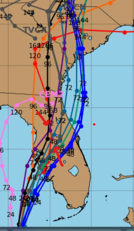
No reliable model has Ian getting back into the Atlantic.
2 likes   
M a r k
- - - - -
Join us in chat: Storm2K Chatroom Invite. Android and IOS apps also available.

The posts in this forum are NOT official forecasts and should not be used as such. Posts are NOT endorsed by any professional institution or STORM2K.org. For official information and forecasts, please refer to NHC and NWS products.

User avatar
Blinhart
Category 5
Category 5
Posts: 2079
Age: 48
Joined: Thu Sep 08, 2011 3:13 pm
Location: Crowley, La.

Re: ATL: IAN - Models

#3173 Postby Blinhart » Tue Sep 27, 2022 8:29 am

tolakram wrote:
pgoss11 wrote:
dspguy wrote:What sort of intensity would one expect if Ian crosses FL and then gets out over open water before turning into SC?

That’s a hard question to answer. Much depends on the strength of Ian when he exits the peninsula and how fast the storm is moving. It’s a wait and see.


No reliable model has Ian getting back into the Atlantic.


I see quite a few on the spaghetti models showing it going back into the Atlantic now.
2 likes   
Personal Forecast Disclaimer:
The posts in this forum are NOT official forecast and should not be used as such. They are just the opinion of the poster and may or may not be backed by sound meteorological data. They are NOT endorsed by any professional institution or storm2k.org. For official information, please refer to the NHC and NWS products.

User avatar
pgoss11
Category 2
Category 2
Posts: 702
Joined: Tue Sep 02, 2003 3:55 pm

Re: ATL: IAN - Models

#3174 Postby pgoss11 » Tue Sep 27, 2022 8:32 am

tolakram wrote:
pgoss11 wrote:
dspguy wrote:What sort of intensity would one expect if Ian crosses FL and then gets out over open water before turning into SC?

That’s a hard question to answer. Much depends on the strength of Ian when he exits the peninsula and how fast the storm is moving. It’s a wait and see.


No reliable model has Ian getting back into the Atlantic.


Only the UKMET so far but this conversation was regarding possible future east shifts and the potential for is possible getting into the Atlantic.. not the current situation
1 likes   

User avatar
SFLcane
S2K Supporter
S2K Supporter
Posts: 10163
Age: 47
Joined: Sat Jun 05, 2010 1:44 pm
Location: Lake Worth Florida

Re: ATL: IAN - Models

#3175 Postby SFLcane » Tue Sep 27, 2022 8:39 am

Official in black and grey is consensus model tcvn you can see the shift SE.

Image
2 likes   

User avatar
Stormgodess
Category 1
Category 1
Posts: 301
Joined: Mon Sep 14, 2020 1:31 am

Re: ATL: IAN - Models

#3176 Postby Stormgodess » Tue Sep 27, 2022 8:43 am

Blinhart wrote:
tolakram wrote:
pgoss11 wrote:That’s a hard question to answer. Much depends on the strength of Ian when he exits the peninsula and how fast the storm is moving. It’s a wait and see.


No reliable model has Ian getting back into the Atlantic.


I see quite a few on the spaghetti models showing it going back into the Atlantic now.


The whole eastern seaboard looks a mess, like it's pulling Ian moisture into it. I was noticing that earlier and wondering what mechanics was behind it all. Since I genuinely know nothing
2 likes   

cane5
Category 1
Category 1
Posts: 252
Joined: Fri Jul 02, 2021 4:24 pm

Re: ATL: IAN - Models

#3177 Postby cane5 » Tue Sep 27, 2022 8:45 am

We knew nothing until it really encountered more things and when it became a full hurricane. This continues to trend east closer to Ft Myers. We need to get on top of the ICON model it’s been reliable can anyone update that my del please.
2 likes   

User avatar
SFLcane
S2K Supporter
S2K Supporter
Posts: 10163
Age: 47
Joined: Sat Jun 05, 2010 1:44 pm
Location: Lake Worth Florida

Re: ATL: IAN - Models

#3178 Postby SFLcane » Tue Sep 27, 2022 8:50 am

certainly think this is on the table now...

Image
7 likes   

TallyTracker
Category 2
Category 2
Posts: 734
Joined: Thu Oct 11, 2018 2:46 pm

Re: ATL: IAN - Models

#3179 Postby TallyTracker » Tue Sep 27, 2022 8:59 am

To emphasize the model spread:

06z Euro = Tampa Bay Landfall
06z GFS = Venice/Sarasota Landfall
06z ICON = Pine Island/Port Charlotte Landfall
00z CMC = Cedar Key Landfall

The final landfall location is far from certain. That’s 180 miles of spread yet as the crow flies.
3 likes   
Fran '96, Georges '98, Gordon '00, Gabrielle '01, Charley '04, Frances '04, Jeanne '04, Barry '07, Fay '08, Debby '12, Matthew '16, Emily '17, Irma '17, Michael ‘18, Elsa ‘21, Fred ‘21, Mindy ‘21, Nicole ‘22, Idalia ‘23, Debby ‘24, Helene ‘24

User avatar
eastcoastFL
Category 5
Category 5
Posts: 3901
Age: 43
Joined: Thu Apr 12, 2007 12:29 pm
Location: Palm City, FL

Re: ATL: IAN - Models

#3180 Postby eastcoastFL » Tue Sep 27, 2022 9:09 am

SFLcane wrote:Official in black and grey is consensus model tcvn you can see the shift SE.

https://i.postimg.cc/HLZgxM34/ccc-jpeg.jpg


One solid consistency over the past 48 hours has been models shifting east. It’s been endless and admittedly a bit scary. Now with the trough moving in it’s becoming more of a when rather than an if.
3 likes   
Personal Forecast Disclaimer:
The posts in this forum are NOT official forecast and should not be used as such. They are just the opinion of the poster and may or may not be backed by sound meteorological data. They are NOT endorsed by any professional institution or storm2k.org. For official information, please refer to the NHC and NWS products.


Return to “2022”

Who is online

Users browsing this forum: No registered users and 11 guests