ATL: IAN - Models
Moderator: S2k Moderators
-
Iceresistance

- Category 5

- Posts: 9598
- Age: 22
- Joined: Sat Oct 10, 2020 9:45 am
- Location: Tecumseh, OK/Norman, OK
Re: ATL: INVEST 98L - Models
The GFS is 2-3 hours late because of the network problems, must've been a big one.
0 likes
Bill 2015 & Beta 2020
Winter 2020-2021
All observations are in Tecumseh, OK unless otherwise noted.
Winter posts are focused mainly for Oklahoma & Texas.
Take any of my forecasts with a grain of salt, refer to the NWS, SPC, and NHC for official information
Never say Never with weather! Because ANYTHING is possible!
Winter 2020-2021
All observations are in Tecumseh, OK unless otherwise noted.
Winter posts are focused mainly for Oklahoma & Texas.
Take any of my forecasts with a grain of salt, refer to the NWS, SPC, and NHC for official information
Never say Never with weather! Because ANYTHING is possible!
-
SFLcane

- S2K Supporter

- Posts: 10281
- Age: 48
- Joined: Sat Jun 05, 2010 1:44 pm
- Location: Lake Worth Florida
Re: ATL: INVEST 98L - Models
This would certainly be lights out for millions across South Florida.
1 likes
-
AutoPenalti
- Category 5
- Posts: 4091
- Age: 29
- Joined: Mon Aug 17, 2015 4:16 pm
- Location: Ft. Lauderdale, Florida
Re: ATL: INVEST 98L - Models
SFLcane wrote:This would certainly be lights out for millions across South Florida.
https://i.postimg.cc/NMGBnKJ6/ecmwf.gif
I noticed the timing has lowered from 10/1 to 9/29...
0 likes
The posts in this forum are NOT official forecasts and should not be used as such. They are just the opinion of the poster and may or may not be backed by sound meteorological data. They are NOT endorsed by any professional institution or STORM2K. For official information, please refer to products from the NHC and NWS.
Model Runs Cheat Sheet:
GFS (5:30 AM/PM, 11:30 AM/PM)
HWRF, GFDL, UKMET, NAVGEM (6:30-8:00 AM/PM, 12:30-2:00 AM/PM)
ECMWF (1:45 AM/PM)
TCVN is a weighted averaged
-
Spacecoast

- Category 2

- Posts: 773
- Joined: Thu Aug 31, 2017 2:03 pm
Re: ATL: INVEST 98L - Models
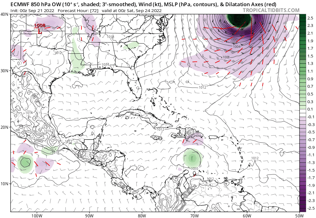
Blown Away wrote:cycloneye wrote:https://i.imgur.com/NClt4zo.png
I'm always puzzled when the GFS (AVN2) is the far W outlier in a model run, especially when the Euro (AEMI) is much farther E.
Anybody got thoughts on this?
AVN2 is the 12hr interpolated version of the GFS (AVN0)
AEMI is the GEFS ensemble mean, (not Euro) which sometimes aligns with AVN0, but not always. GEFS runs a different, earlier version.
0 likes
-
jlauderdal
- S2K Supporter
- Posts: 7240
- Joined: Wed May 19, 2004 5:46 am
- Location: NE Fort Lauderdale
- Contact:
Re: ATL: INVEST 98L - Models
TVCN is NHC default track, they need a really good reason to deviate from it. If you are near the TVCN line, you have trouble brewing.
0 likes
-
SFLcane
- S2K Supporter
- Posts: 10281
- Age: 48
- Joined: Sat Jun 05, 2010 1:44 pm
- Location: Lake Worth Florida
Re: ATL: INVEST 98L - Models
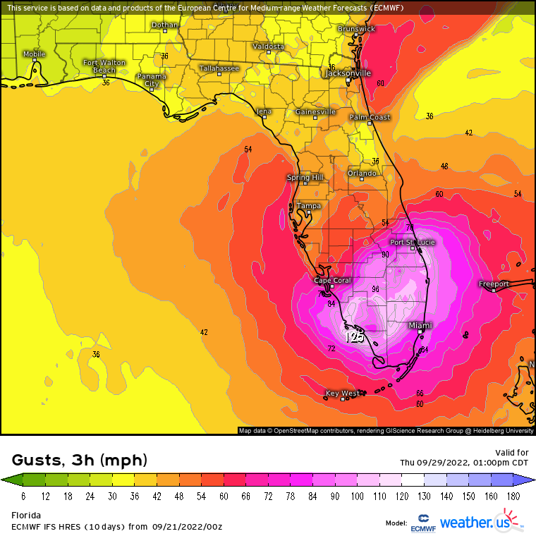
Just a bit windy across South Florida on the Euro. This event would rival that of wilma for most of South Florida.
4 likes
-
SFLcane
- S2K Supporter
- Posts: 10281
- Age: 48
- Joined: Sat Jun 05, 2010 1:44 pm
- Location: Lake Worth Florida
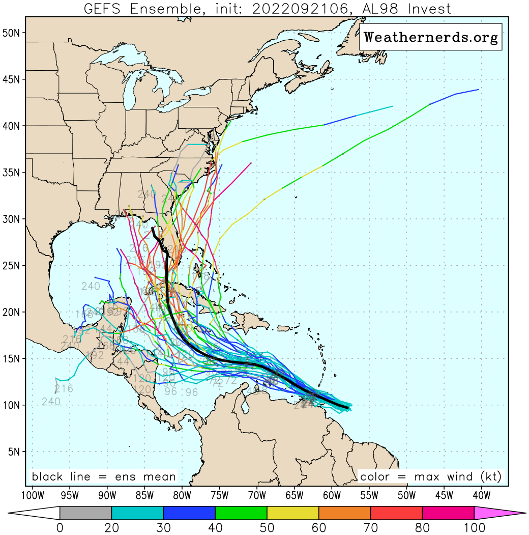
Re: ATL: INVEST 98L - Models
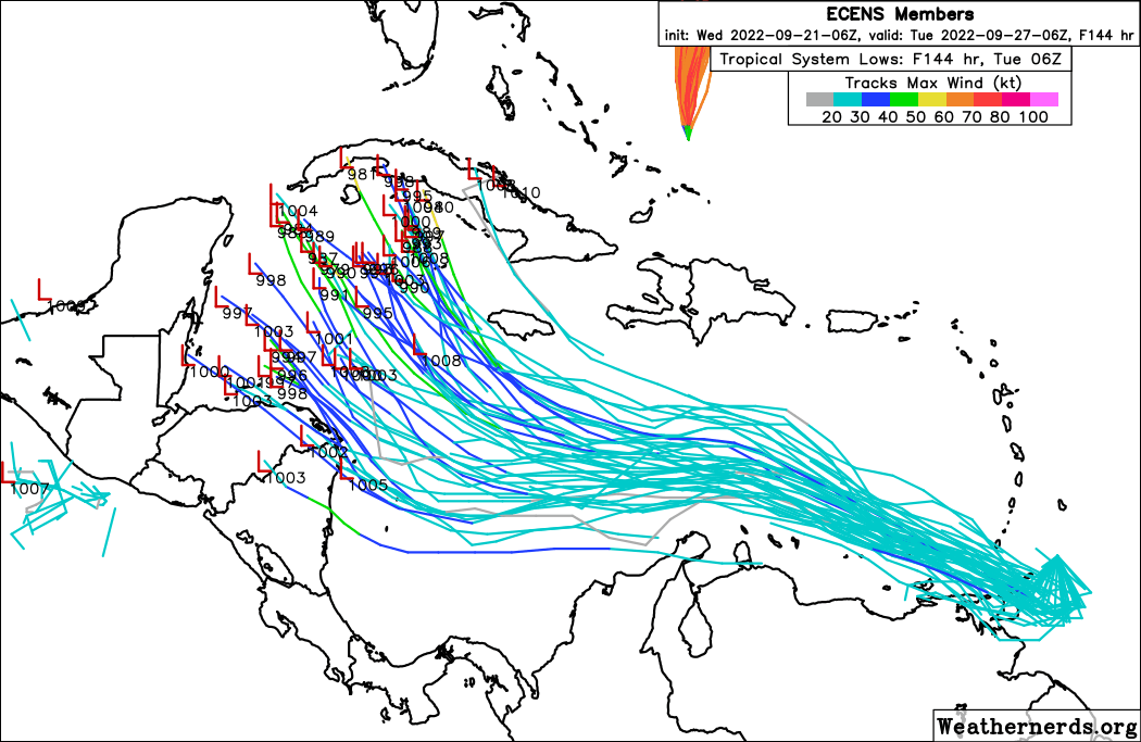
06z EPS.. You can see the growing cluster of members over Cuba and Cayman islands.
Last edited by SFLcane on Wed Sep 21, 2022 9:08 am, edited 1 time in total.
0 likes
-
Spacecoast
- Category 2
- Posts: 773
- Joined: Thu Aug 31, 2017 2:03 pm
Re: ATL: INVEST 98L - Models
Does that look like a decent west shift from 0z?
EDIT: Yes, it does...
Comparison 0z to 6z...


Last edited by Spacecoast on Wed Sep 21, 2022 9:23 am, edited 1 time in total.
0 likes
-
AutoPenalti
- Category 5
- Posts: 4091
- Age: 29
- Joined: Mon Aug 17, 2015 4:16 pm
- Location: Ft. Lauderdale, Florida
Re: ATL: INVEST 98L - Models
SFLcane wrote:Just a bit windy across South Florida on the Euro. This event would rival that of wilma for most of South Florida.
https://i.postimg.cc/YCTQqcGV/ecmgust.png
We have afternoon showers that were stronger than that.
In all seriousness, still far out in time so this will change.
0 likes
The posts in this forum are NOT official forecasts and should not be used as such. They are just the opinion of the poster and may or may not be backed by sound meteorological data. They are NOT endorsed by any professional institution or STORM2K. For official information, please refer to products from the NHC and NWS.
Model Runs Cheat Sheet:
GFS (5:30 AM/PM, 11:30 AM/PM)
HWRF, GFDL, UKMET, NAVGEM (6:30-8:00 AM/PM, 12:30-2:00 AM/PM)
ECMWF (1:45 AM/PM)
TCVN is a weighted averaged
-
SFLcane
- S2K Supporter
- Posts: 10281
- Age: 48
- Joined: Sat Jun 05, 2010 1:44 pm
- Location: Lake Worth Florida
Re: ATL: INVEST 98L - Models
AutoPenalti wrote:SFLcane wrote:Just a bit windy across South Florida on the Euro. This event would rival that of wilma for most of South Florida.
https://i.postimg.cc/YCTQqcGV/ecmgust.png
We have afternoon showers that were stronger than that.
In all seriousness, still far out in time so this will change.
I can't see how this gets far north in the gulf without getting yanked eastward sooner rather then later IF the euro is right.
0 likes

Re: ATL: INVEST 98L - Models
Ensembles mean continue to be on the east side of the operational.
1 likes
The following post is NOT an official forecast and should not be used as such. It is just the opinion of the poster and may or may not be backed by sound meteorological data. It is NOT endorsed by any professional institution including storm2k.org For Official Information please refer to the NHC and NWS products.
-
SFLcane
- S2K Supporter
- Posts: 10281
- Age: 48
- Joined: Sat Jun 05, 2010 1:44 pm
- Location: Lake Worth Florida
Re: ATL: INVEST 98L - Models
blp wrote:Ensembles mean continue to be on the east side of the operational.
https://uploads.disquscdn.com/images/1192e85e3a2af9c1776dcbbe1fe31b5b8613ed60b276ac861ffec94775e39d89.png
yea, ensemble mean will not agree with OP and continues to be on the east side.
0 likes
-
wxman57

- Moderator-Pro Met

- Posts: 23175
- Age: 68
- Joined: Sat Jun 21, 2003 8:06 pm
- Location: Houston, TX (southwest)
Re: ATL: INVEST 98L - Models
Note that the TVCN likely missed the 6Z GFS data, which is why it's farther east.
4 likes
-
SFLcane
- S2K Supporter
- Posts: 10281
- Age: 48
- Joined: Sat Jun 05, 2010 1:44 pm
- Location: Lake Worth Florida
Re: ATL: INVEST 98L - Models
wxman57 wrote:
Note that the TVCN likely missed the 6Z GFS data, which is why it's farther east.
Talk to us about South Florida? What is your take on the 00z Euro?
Appreciate your insight.
0 likes
Re: ATL: INVEST 98L - Models
wxman57 wrote:
Note that the TVCN likely missed the 6Z GFS data, which is why it's farther east.
Do you mean it's, for lack of a better term, a bogus run, or lacking data?
0 likes
-
Iceresistance
- Category 5
- Posts: 9598
- Age: 22
- Joined: Sat Oct 10, 2020 9:45 am
- Location: Tecumseh, OK/Norman, OK
Re: ATL: INVEST 98L - Models
underthwx wrote:wxman57 wrote:SFLcane wrote:
Shift east Tcvn..
Note that the TVCN likely missed the 6Z GFS data, which is why it's farther east.
Do you mean it's, for lack of a better term, a bogus run, or lacking data?
There was a outage this morning that likely factored why the TVCN may have missed the 6z GFS run, which also factored why it shifted east even more.
1 likes
Bill 2015 & Beta 2020
Winter 2020-2021
All observations are in Tecumseh, OK unless otherwise noted.
Winter posts are focused mainly for Oklahoma & Texas.
Take any of my forecasts with a grain of salt, refer to the NWS, SPC, and NHC for official information
Never say Never with weather! Because ANYTHING is possible!
Winter 2020-2021
All observations are in Tecumseh, OK unless otherwise noted.
Winter posts are focused mainly for Oklahoma & Texas.
Take any of my forecasts with a grain of salt, refer to the NWS, SPC, and NHC for official information
Never say Never with weather! Because ANYTHING is possible!
-
skyline385

- Category 5
- Posts: 2728
- Age: 35
- Joined: Wed Aug 26, 2020 11:15 pm
- Location: Houston TX
Re: ATL: INVEST 98L - Models
Weenie jokes aside, todays SHIPS is a sign of how favorable the conditions for 98L could potentially be.
https://twitter.com/webberweather/status/1572598639918485505
Sent from my iPhone using Tapatalk
https://twitter.com/webberweather/status/1572598639918485505
Sent from my iPhone using Tapatalk
3 likes

Re: ATL: INVEST 98L - Models
So I shift west is most likely? It seems like the panhandle is ground zero with the models
0 likes

Re: ATL: INVEST 98L - Models
SFLcane wrote:AutoPenalti wrote:SFLcane wrote:Just a bit windy across South Florida on the Euro. This event would rival that of wilma for most of South Florida.
https://i.postimg.cc/YCTQqcGV/ecmgust.png
We have afternoon showers that were stronger than that.
In all seriousness, still far out in time so this will change.
I can't see how this gets far north in the gulf without getting yanked eastward sooner rather then later IF the euro is right.
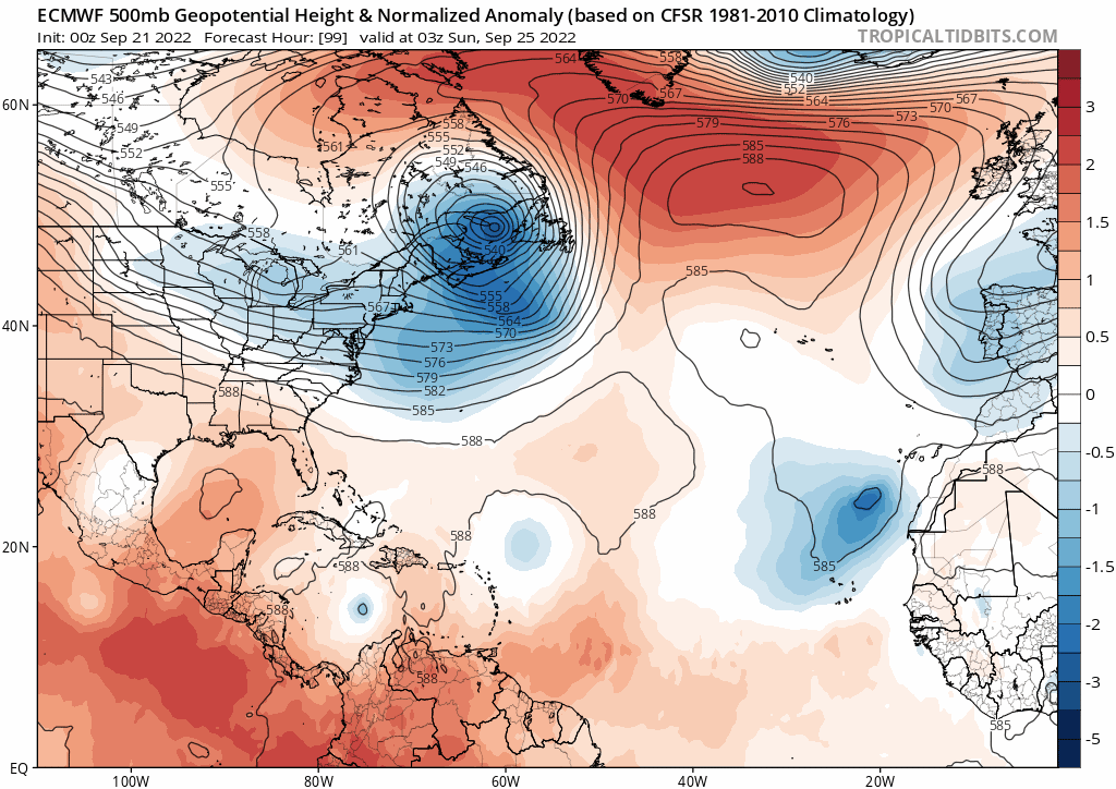
https://i.postimg.cc/gj5JpZNZ/ecmtt.gif
It's 8 days out. It's not going to be 100% right. What you can or should be able to see is high pressure building back over the top though that doesn't really happen all that much later in the year - more of an earlier in the season dynamic. I'd agree that the likelihood of a NE pull makes sense, but I'm not basing that off an upper model that far out - not the specifics anyway.
2 likes
-
SFLcane
- S2K Supporter
- Posts: 10281
- Age: 48
- Joined: Sat Jun 05, 2010 1:44 pm
- Location: Lake Worth Florida
Re: ATL: INVEST 98L - Models
boca wrote:So I shift west is most likely? It seems like the panhandle is ground zero with the models
The entire eastern gulf including Florida is fair game in my opinion.
3 likes
Who is online
Users browsing this forum: No registered users and 15 guests