ATL: EARL - Post-Tropical - Discussion

Moderator: S2k Moderators

Message
Author
hipshot
Category 2
Category 2
Posts: 591
Joined: Tue Jul 06, 2010 9:18 pm
Location: Dallas, Texas

Re: ATL: EARL - Tropical Storm - Discussion

#501 Postby hipshot » Sun Sep 04, 2022 8:19 am

cycloneye wrote:
AL, 06, 2022090412, , BEST, 0, 195N, 644W, 45, 998, TS


https://ftp.nhc.noaa.gov/atcf/btk/bal062022.dat

Going back and looking at your previous posts and Earl isn't moving much and what it's not doing
is turning north (yet) and slowing chugging west. Is the NHC still calling for a turn north and then out to sea?
The posts in this forum are NOT official forecasts and should not be used as such. They are just the opinion of the poster and may or may not be backed by sound meteorological data. They are NOT endorsed by any professional institution or STORM2K. For official information, please refer to products from the NHC and NWS.
0 likes   

tolakram
Admin
Admin
Posts: 20009
Age: 62
Joined: Sun Aug 27, 2006 8:23 pm
Location: Florence, KY (name is Mark)

Re: ATL: EARL - Tropical Storm - Discussion

#502 Postby tolakram » Sun Sep 04, 2022 8:30 am

hipshot wrote:
tolakram wrote:saved loop
https://i.imgur.com/9BAfeHl.gif


That surely makes it look like it took a jog toward the east right near the end of that loop or...
it was an optical illusion. :double:
The posts in this forum are NOT official forecasts and should not be used as such. They are just the opinion of the poster and may or may not be backed by sound meteorological data. They are NOT endorsed by any professional institution or STORM2K. For official information, please refer to products from the NHC and NWS.


At that distance we are looking way up in the atmosphere at the MLC. I suspect it's just changing as shear changes.
1 likes   
M a r k
- - - - -
Join us in chat: Storm2K Chatroom Invite. Android and IOS apps also available.

The posts in this forum are NOT official forecasts and should not be used as such. Posts are NOT endorsed by any professional institution or STORM2K.org. For official information and forecasts, please refer to NHC and NWS products.

tolakram
Admin
Admin
Posts: 20009
Age: 62
Joined: Sun Aug 27, 2006 8:23 pm
Location: Florence, KY (name is Mark)

Re: ATL: EARL - Tropical Storm - Discussion

#503 Postby tolakram » Sun Sep 04, 2022 8:31 am

0 likes   
M a r k
- - - - -
Join us in chat: Storm2K Chatroom Invite. Android and IOS apps also available.

The posts in this forum are NOT official forecasts and should not be used as such. Posts are NOT endorsed by any professional institution or STORM2K.org. For official information and forecasts, please refer to NHC and NWS products.

User avatar
Teban54
Category 5
Category 5
Posts: 3204
Joined: Sat May 19, 2018 1:19 pm

Re: ATL: EARL - Tropical Storm - Discussion

#504 Postby Teban54 » Sun Sep 04, 2022 8:34 am

I don't remember seeing such cold cloud tops from a TC this season...
Image
4 likes   

User avatar
Category5Kaiju
Category 5
Category 5
Posts: 4097
Joined: Thu Dec 24, 2020 12:45 pm
Location: Seattle

Re: ATL: EARL - Tropical Storm - Discussion

#505 Postby Category5Kaiju » Sun Sep 04, 2022 8:40 am

Atlantic: "Oh no, I am falling behind in ACE and people are already trying to cancel me! What should I do?"

Mother Nature: "Quick, unleash the Earl!!"
8 likes   
Unless explicitly stated, all info in my posts is based on my own opinions and observations. Tropical storms and hurricanes can be extremely dangerous. Do not think you can beat Mother Nature. Refer to an accredited weather research agency or meteorologist if you need to make serious decisions regarding an approaching storm.

User avatar
Teban54
Category 5
Category 5
Posts: 3204
Joined: Sat May 19, 2018 1:19 pm

Re: ATL: EARL - Tropical Storm - Discussion

#506 Postby Teban54 » Sun Sep 04, 2022 8:45 am

0 likes   

User avatar
Emmett_Brown
Category 5
Category 5
Posts: 1432
Joined: Wed Aug 24, 2005 9:10 pm
Location: Sarasota FL

Re: ATL: EARL - Tropical Storm - Discussion

#507 Postby Emmett_Brown » Sun Sep 04, 2022 8:46 am

Recon data is coming in intermittently this morning. Earl's center appears to be stretched out west to east, with a new center forming under the convection.
0 likes   

User avatar
wxman57
Moderator-Pro Met
Moderator-Pro Met
Posts: 22978
Age: 67
Joined: Sat Jun 21, 2003 8:06 pm
Location: Houston, TX (southwest)

Re: ATL: EARL - Tropical Storm - Discussion

#508 Postby wxman57 » Sun Sep 04, 2022 8:48 am

Recon is reporting a very odd wind field. Winds blowing in opposite directions along 64.9W.
1 likes   

User avatar
Emmett_Brown
Category 5
Category 5
Posts: 1432
Joined: Wed Aug 24, 2005 9:10 pm
Location: Sarasota FL

Re: ATL: EARL - Tropical Storm - Discussion

#509 Postby Emmett_Brown » Sun Sep 04, 2022 8:56 am

wxman57 wrote:Recon is reporting a very odd wind field. Winds blowing in opposite directions along 64.9W.


Perhaps due to the center reforming. The winds in that area are really weak, so maybe they changed direction between passes as the center reformed.
2 likes   

User avatar
Emmett_Brown
Category 5
Category 5
Posts: 1432
Joined: Wed Aug 24, 2005 9:10 pm
Location: Sarasota FL

Re: ATL: EARL - Tropical Storm - Discussion

#510 Postby Emmett_Brown » Sun Sep 04, 2022 9:04 am

Satellite images show a large CDO, and look more impressive than yesterday. Earl has weakened significantly per recon, probably due to the ongoing process of the center reforming near/under the convection. If Earl's new convection gets stripped away while the center is still relocating, Earl may just be a weak swirl later today... so while he looks impressive, he might actually be blowing himself up.
1 likes   

User avatar
aspen
Category 5
Category 5
Posts: 8818
Joined: Sat Oct 12, 2019 7:10 pm
Location: Connecticut, USA

Re: ATL: EARL - Tropical Storm - Discussion

#511 Postby aspen » Sun Sep 04, 2022 9:05 am

This reminds me a lot of Sally during its center reformation that propelled it to hurricane status. The hurricane models could be right about Earl becoming a hurricane in the next 24-36 hours due to this reformation.
2 likes   
Irene '11 Sandy '12 Hermine '16 5/15/2018 Derecho Fay '20 Isaias '20 Elsa '21 Henri '21 Ida '21

I am only a meteorology enthusiast who knows a decent amount about tropical cyclones. Look to the professional mets, the NHC, or your local weather office for the best information.

tolakram
Admin
Admin
Posts: 20009
Age: 62
Joined: Sun Aug 27, 2006 8:23 pm
Location: Florence, KY (name is Mark)

Re: ATL: EARL - Tropical Storm - Discussion

#512 Postby tolakram » Sun Sep 04, 2022 9:15 am

The distant radar image doesn't really help. Earl may have made a north turn, ot like the HWRF shows the center is weak and bouncing all over the place.

saved loop
Image
0 likes   
M a r k
- - - - -
Join us in chat: Storm2K Chatroom Invite. Android and IOS apps also available.

The posts in this forum are NOT official forecasts and should not be used as such. Posts are NOT endorsed by any professional institution or STORM2K.org. For official information and forecasts, please refer to NHC and NWS products.

User avatar
DorkyMcDorkface
Category 3
Category 3
Posts: 888
Age: 27
Joined: Mon Sep 30, 2019 1:32 pm
Location: Mid-Atlantic

Re: ATL: EARL - Tropical Storm - Discussion

#513 Postby DorkyMcDorkface » Sun Sep 04, 2022 9:21 am

Looks like a center reformation to me as the deeper convection fires downshear. Don't think the storm will take off immediately but it bodes well for future strengthening definitely.
1 likes   
Please note the thougths expressed by this account are solely those of the user and are from a hobbyist perspective. For more comprehensive analysis, consult an actual professional meteorologist or meteorology agency.


Floyd 1999 | Isabel 2003 | Hanna 2008 | Irene 2011 | Sandy 2012 | Isaias 2020

tolakram
Admin
Admin
Posts: 20009
Age: 62
Joined: Sun Aug 27, 2006 8:23 pm
Location: Florence, KY (name is Mark)

Re: ATL: EARL - Tropical Storm - Discussion

#514 Postby tolakram » Sun Sep 04, 2022 9:22 am

Looks like Earl has to get past the jet stream first. Look at that shear pattern.

Image
4 likes   
M a r k
- - - - -
Join us in chat: Storm2K Chatroom Invite. Android and IOS apps also available.

The posts in this forum are NOT official forecasts and should not be used as such. Posts are NOT endorsed by any professional institution or STORM2K.org. For official information and forecasts, please refer to NHC and NWS products.

User avatar
aspen
Category 5
Category 5
Posts: 8818
Joined: Sat Oct 12, 2019 7:10 pm
Location: Connecticut, USA

Re: ATL: EARL - Tropical Storm - Discussion

#515 Postby aspen » Sun Sep 04, 2022 9:55 am

Jeez, today’s recon communication problems are awful. It’s been nearly an hour since they transmitted anything, so no way to tell how Earl’s center reformation is coming along.

Also the 11am forecast has Earl become a major in 5 days.
0 likes   
Irene '11 Sandy '12 Hermine '16 5/15/2018 Derecho Fay '20 Isaias '20 Elsa '21 Henri '21 Ida '21

I am only a meteorology enthusiast who knows a decent amount about tropical cyclones. Look to the professional mets, the NHC, or your local weather office for the best information.

User avatar
msbee
S2K Supporter
S2K Supporter
Posts: 3027
Joined: Wed Jun 11, 2003 10:11 am
Location: St. Maarten

Re: ATL: EARL - Models

#516 Postby msbee » Sun Sep 04, 2022 9:56 am

Good morning
Current conditions in St Maarten.
Overcast, windy, rough seas.
not much rain.
1 hour ago the report from the airport was wind from the south/southeast at 16kt with gusts up to 25kt.
Looking at satellite imagery I hope Earl does turn moreNorth and not cause Puerto Rico any problems.
0 likes   
Too many hurricanes to remember

tolakram
Admin
Admin
Posts: 20009
Age: 62
Joined: Sun Aug 27, 2006 8:23 pm
Location: Florence, KY (name is Mark)

Re: ATL: EARL - Tropical Storm - Discussion

#517 Postby tolakram » Sun Sep 04, 2022 10:18 am

Earl is now forecast to become a major.

Image
3 likes   
M a r k
- - - - -
Join us in chat: Storm2K Chatroom Invite. Android and IOS apps also available.

The posts in this forum are NOT official forecasts and should not be used as such. Posts are NOT endorsed by any professional institution or STORM2K.org. For official information and forecasts, please refer to NHC and NWS products.

tolakram
Admin
Admin
Posts: 20009
Age: 62
Joined: Sun Aug 27, 2006 8:23 pm
Location: Florence, KY (name is Mark)

Re: ATL: EARL - Tropical Storm - Discussion

#518 Postby tolakram » Sun Sep 04, 2022 10:18 am

000
WTNT41 KNHC 041459
TCDAT1

Tropical Storm Earl Discussion Number 7
NWS National Hurricane Center Miami FL AL062022
1100 AM AST Sun Sep 04 2022

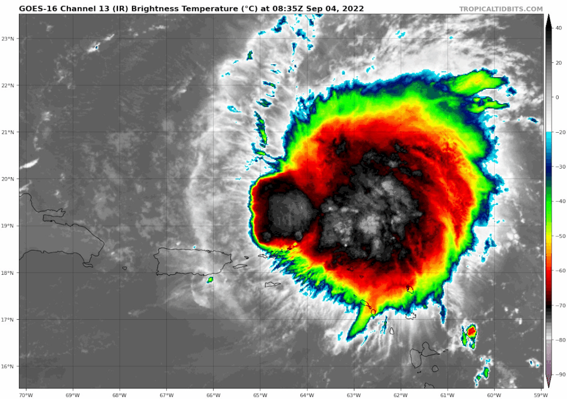
This morning, Earl developed a large convective burst, with cold
convective cloud tops below -80 C and the larger cirrus plume
obscuring the low-level center. A NOAA-P3 mission has also be flying
through Earl this morning, showing that the center may be in the
process of reorganizing closer to this recent convective burst.
WSR-88D radar imagery from Puerto Rico earlier showed a well-defined
mid-level vortex associated with this convective burst up at 20 k
feet, which matched the NOAA-P3 TDR data, but it is unclear how
close the surface vortex is relative to this mid-level center.
Subjective Dvorak estimates from TAFB and SAB are T3.0/45-kt and
T3.5/55-kt respectively, though objective estimates are somewhat
lower, with ADT only at 33-kt and SATCON at 44-kt. A blend of these
estimates and the wind data from the NOAA-P3 mission support
maintaining the intensity at 45 kt for this advisory.

Earl appears to have slowed down further this morning, and may be in
the process of relocating closer to the convective burst, with the
latest motion an uncertain 310/3 kt. As mentioned previously, there
is a weakness in the mid-level ridging to the north of the storm,
and this should enable Earl to make a gradual turn to the
north-northwest and north over the next 24-72 hours. The mid-level
ridging then shifts mostly east of the cyclone, allowing a continued
slow north-northeastward motion thereafter. The latest track
guidance has shifted east in the short term due in part to the
initial position, and the latest NHC track forecast has been shifted
in that direction and lies just west of TVCN consensus. However, the
latest track forecast is not as far to the east as the HFIP
Corrected Consensus (HCCA), GFS or HWRF forecasts, and additional
eastward adjustments may be needed in subsequent forecasts.

The large convective burst this morning makes the short-term
intensity forecast somewhat tricky. If the low-level center is able
to reform and become better aligned with the mid-level center, some
intensification could occur. If and when this occurs is important,
with the latest HWRF and GFS forecasts suggesting this could occur
as soon as later today, resulting in more significant
intensification. However, the HMON, HAFS-S, and ECMWF suggest it may
take a few days for a more aligned structure to occur, likely
delayed by continued moderate (15-25 kts) southwesterly vertical
wind shear, which is expected to persist for the next 2-3 days. The
latest NHC intensity forecast opts to split the difference, now
showing gradual intensification over the next 24-48 hours, making
Earl a hurricane in 48 hours. This is higher than the previous NHC
intensity forecast, but is under the latest HCCA, HWRF, and
GFS-SHIPS guidance. After 72 h, shear is expected to decrease, and
more robust intensification is possible thereafter, with the latest
intensity forecast now making Earl a major hurricane by 120 h, in
good agreement with the IVCN and HCCA consensus aids.

At this juncture, tropical-storm-force winds are still forecast to
remain on the northern and eastern side of the circulation, and are
not expected to move across the northern Leeward Islands, the Virgin
Islands, or Puerto Rico. However, gusty winds in squalls are
possible at these locations through tonight.


KEY MESSAGES:

1. Heavy rainfall from Earl is expected to lead to limited flash,
urban, and small stream flooding impacts over the Leeward Islands,
U.S. and British Virgin Islands, and Puerto Rico today. Rapid
rises on rivers and mudslides in areas of steep terrain are possible
in Puerto Rico.

2. Earl is forecast to pass to the north of the the Virgin Islands
and Puerto Rico today, but gusty winds, especially in squalls,
remain possible on those islands.


FORECAST POSITIONS AND MAX WINDS

INIT 04/1500Z 19.5N 64.4W 45 KT 50 MPH
12H 05/0000Z 20.4N 65.0W 50 KT 60 MPH
24H 05/1200Z 21.5N 65.2W 55 KT 65 MPH
36H 06/0000Z 22.6N 65.4W 60 KT 70 MPH
48H 06/1200Z 23.5N 65.5W 65 KT 75 MPH
60H 07/0000Z 24.7N 65.4W 70 KT 80 MPH
72H 07/1200Z 25.7N 65.0W 75 KT 85 MPH
96H 08/1200Z 27.2N 64.0W 85 KT 100 MPH
120H 09/1200Z 29.6N 61.8W 100 KT 115 MPH

$$
Forecaster Papin
0 likes   
M a r k
- - - - -
Join us in chat: Storm2K Chatroom Invite. Android and IOS apps also available.

The posts in this forum are NOT official forecasts and should not be used as such. Posts are NOT endorsed by any professional institution or STORM2K.org. For official information and forecasts, please refer to NHC and NWS products.

User avatar
NotSparta
Professional-Met
Professional-Met
Posts: 1669
Age: 23
Joined: Fri Aug 18, 2017 8:24 am
Location: Naples, FL
Contact:

Re: ATL: EARL - Tropical Storm - Discussion

#519 Postby NotSparta » Sun Sep 04, 2022 10:29 am

aspen wrote:Jeez, today’s recon communication problems are awful. It’s been nearly an hour since they transmitted anything, so no way to tell how Earl’s center reformation is coming along.

Also the 11am forecast has Earl become a major in 5 days.


They finished at 10, landed back in the Virgin Islands
0 likes   
This post was probably an opinion of mine, and in no way is official. Please refer to http://www.hurricanes.gov for official tropical analysis and advisories.

My website, with lots of tropical wx graphics, including satellite and recon: http://cyclonicwx.com

Sciencerocks
Category 5
Category 5
Posts: 9155
Age: 39
Joined: Thu Jul 06, 2017 1:51 am

Re: ATL: EARL - Tropical Storm - Discussion

#520 Postby Sciencerocks » Sun Sep 04, 2022 10:41 am

Image
1 likes   


Return to “2022”

Who is online

Users browsing this forum: No registered users and 1 guest