2022 Global Model Runs Discussion (Out thru day 16)
Moderator: S2k Moderators
Forum rules

The posts in this forum are NOT official forecasts and should not be used as such. They are just the opinion of the poster and may or may not be backed by sound meteorological data. They are NOT endorsed by any professional institution or STORM2K. For official information, please refer to products from the National Hurricane Center and National Weather Service.

Re: 2022 Global Model Runs Discussion (Out thru day 16)
The Euro has an EPAC crossover next week bringing widespread rains to Texas.
1 likes

Re: 2022 Global Model Runs Discussion (Out thru day 16)
0z CMC continues to develop the 9/6 wave and now ends the run at 992mb, quite strong for this model in the long range. Heads W and then WNW. The wave behind it might be slowly organizing too.
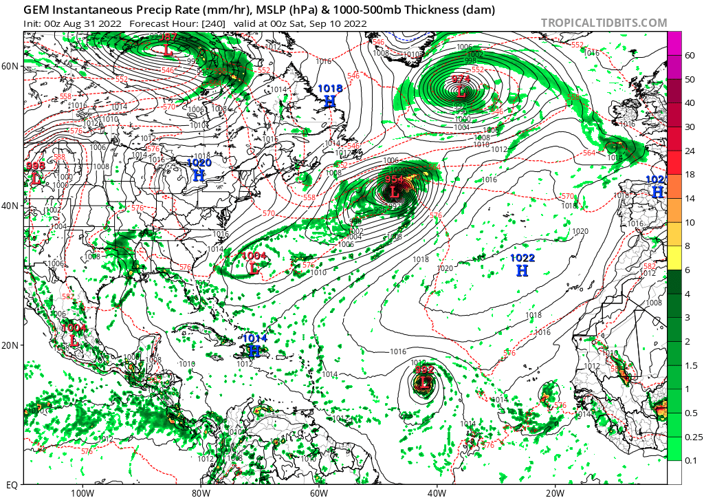
Update: 0z Euro develops the 9/3 wave as it quickly recurves. Through 168 hours, it also shows the 9/6 wave organizing.
Update 2: Euro ends with the 9/6 wave at 991 mb in the central MDR moving west.
Update: 0z Euro develops the 9/3 wave as it quickly recurves. Through 168 hours, it also shows the 9/6 wave organizing.
Update 2: Euro ends with the 9/6 wave at 991 mb in the central MDR moving west.
0 likes
TC naming lists: retirements and intensity
Most aggressive Advisory #1's in North Atlantic (cr. kevin for starting the list)
Most aggressive Advisory #1's in North Atlantic (cr. kevin for starting the list)

Re: 2022 Global Model Runs Discussion (Out thru day 16)
Teban54 wrote:0z CMC continues to develop the 9/6 wave and now ends the run at 992mb, quite strong for this model in the long range. Heads W and then WNW. The wave behind it might be slowly organizing too.
https://i.postimg.cc/GhTLjPwV/image.png
Update: 0z Euro develops the 9/3 wave as it quickly recurves. Through 168 hours, it also shows the 9/6 wave organizing.
Update 2: Euro ends with the 9/6 wave at 991 mb in the central MDR moving west.
I had a feeling that wave might end up as something to watch. So far the GFS still wants to shut down the MDR after 91L moves into the subtropics and the other MDR AOI dissipates, something I’d expect to see from the Euro and CMC, ironically the only two models developing this (it’s outside the time range of the ICON).
Also the wave that exits on 9/9 looks a little interesting.
0 likes
Irene '11 Sandy '12 Hermine '16 5/15/2018 Derecho Fay '20 Isaias '20 Elsa '21 Henri '21 Ida '21
I am only a meteorology enthusiast who knows a decent amount about tropical cyclones. Look to the professional mets, the NHC, or your local weather office for the best information.
I am only a meteorology enthusiast who knows a decent amount about tropical cyclones. Look to the professional mets, the NHC, or your local weather office for the best information.
-
Category5Kaiju

- Category 5

- Posts: 4313
- Joined: Thu Dec 24, 2020 12:45 pm
- Location: Seattle and Phoenix
Re: 2022 Global Model Runs Discussion (Out thru day 16)

CPC does recognize the potential for the 9/6 wave, in fact it delineates a moderate possibility of formation, with an above average precip zone surrounding it.
1 likes
Unless explicitly stated, all info in my posts is based on my own opinions and observations. Tropical storms and hurricanes can be extremely dangerous. Refer to an accredited weather research agency or meteorologist if you need to make serious decisions regarding an approaching storm.
-
Blown Away

- S2K Supporter

- Posts: 10253
- Joined: Wed May 26, 2004 6:17 am
Re: 2022 Global Model Runs Discussion (Out thru day 16)

00z ECMWF has a hurricane moving W across the MDR...
0 likes
Hurricane Eye Experience: David 79, Irene 99, Frances 04, Jeanne 04, Wilma 05… Hurricane Brush Experience: Andrew 92, Erin 95, Floyd 99, Matthew 16, Irma 17, Ian 22, Nicole 22…
-
Category5Kaiju
- Category 5
- Posts: 4313
- Joined: Thu Dec 24, 2020 12:45 pm
- Location: Seattle and Phoenix
Re: 2022 Global Model Runs Discussion (Out thru day 16)
Blown Away wrote:https://i.imgur.com/8qT8J4H.gif
00z ECMWF has a hurricane moving W across the MDR...
Wait, so between the wave right off Africa now that's about to develop and the long track system, Euro thinks there'll be yet another spinup in between? Huh.
0 likes
Unless explicitly stated, all info in my posts is based on my own opinions and observations. Tropical storms and hurricanes can be extremely dangerous. Refer to an accredited weather research agency or meteorologist if you need to make serious decisions regarding an approaching storm.
Re: 2022 Global Model Runs Discussion (Out thru day 16)
12z CMC has that 9/6 wave MDR hurricane again, and still shows another strong south-shifted wave exiting Africa on 9/9. Those two have the best shots of racking up some significant ACE if their precursor waves do indeed come off at such a low latitude.
0 likes
Irene '11 Sandy '12 Hermine '16 5/15/2018 Derecho Fay '20 Isaias '20 Elsa '21 Henri '21 Ida '21
I am only a meteorology enthusiast who knows a decent amount about tropical cyclones. Look to the professional mets, the NHC, or your local weather office for the best information.
I am only a meteorology enthusiast who knows a decent amount about tropical cyclones. Look to the professional mets, the NHC, or your local weather office for the best information.
-
SFLcane

- S2K Supporter
- Posts: 10281
- Age: 48
- Joined: Sat Jun 05, 2010 1:44 pm
- Location: Lake Worth Florida
Re: 2022 Global Model Runs Discussion (Out thru day 16)
aspen wrote:12z CMC has that 9/6 wave MDR hurricane again, and still shows another strong south-shifted wave exiting Africa on 9/9. Those two have the best shots of racking up some significant ACE if their precursor waves do indeed come off at such a low latitude.
Indeed..
2 likes
-
Meteorcane

- Category 2

- Posts: 559
- Joined: Thu Jul 21, 2011 6:49 am
- Location: North Platte Nebraska
Re: 2022 Global Model Runs Discussion (Out thru day 16)
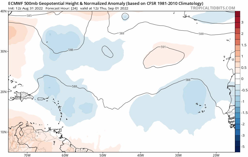
I think the signs are starting to come together for a somewhat active eastern/central MDR starting early next week and likely continuing into the following week. Mid-lvl ridging looks to set up over the eastern Atlantic and then gradually shift westward with time. This would at least limit shear on any waves that develop (particularly if they can develop at relatively low latitude). Possibly would limit mid-latitude dry air intrusions as well, so would not be surprised to see a couple systems develop in that time period... potentially fairly far east as conditions will probably be as favorable as we have seen thus far this season in that part of the Basin.
The lack of GFS/GEFS development is a bit of a wrench in the above assessment , but since we are talking about genesis a week out, I think looking at the large scale pattern is probably a bit more relevant than focusing on specific model cyclones.
The lack of GFS/GEFS development is a bit of a wrench in the above assessment , but since we are talking about genesis a week out, I think looking at the large scale pattern is probably a bit more relevant than focusing on specific model cyclones.
5 likes
-
SFLcane
- S2K Supporter
- Posts: 10281
- Age: 48
- Joined: Sat Jun 05, 2010 1:44 pm
- Location: Lake Worth Florida
Re: 2022 Global Model Runs Discussion (Out thru day 16)
Meteorcane wrote:I think the signs are starting to come together for a somewhat active eastern/central MDR starting early next week and likely continuing into the following week. Mid-lvl ridging looks to set up over the eastern Atlantic and then gradually shift westward with time. This would at least limit shear on any waves that develop (particularly if they can develop at relatively low latitude). Possibly would limit mid-latitude dry air intrusions as well, so would not be surprised to see a couple systems develop in that time period... potentially fairly far east as conditions will probably be as favorable as we have seen thus far this season in that part of the Basin.
The lack of GFS/GEFS development is a bit of a wrench in the above assessment , but since we are talking about genesis a week out, I think looking at the large scale pattern is probably a bit more relevant than focusing on specific model cyclones.
monsoon trough losing influence potentially? The do roll of pretty clean.
0 likes
-
Iceresistance

- Category 5
- Posts: 9441
- Age: 22
- Joined: Sat Oct 10, 2020 9:45 am
- Location: Tecumseh, OK/Norman, OK
Re: 2022 Global Model Runs Discussion (Out thru day 16)
SFLcane wrote:aspen wrote:12z CMC has that 9/6 wave MDR hurricane again, and still shows another strong south-shifted wave exiting Africa on 9/9. Those two have the best shots of racking up some significant ACE if their precursor waves do indeed come off at such a low latitude.
Indeed..
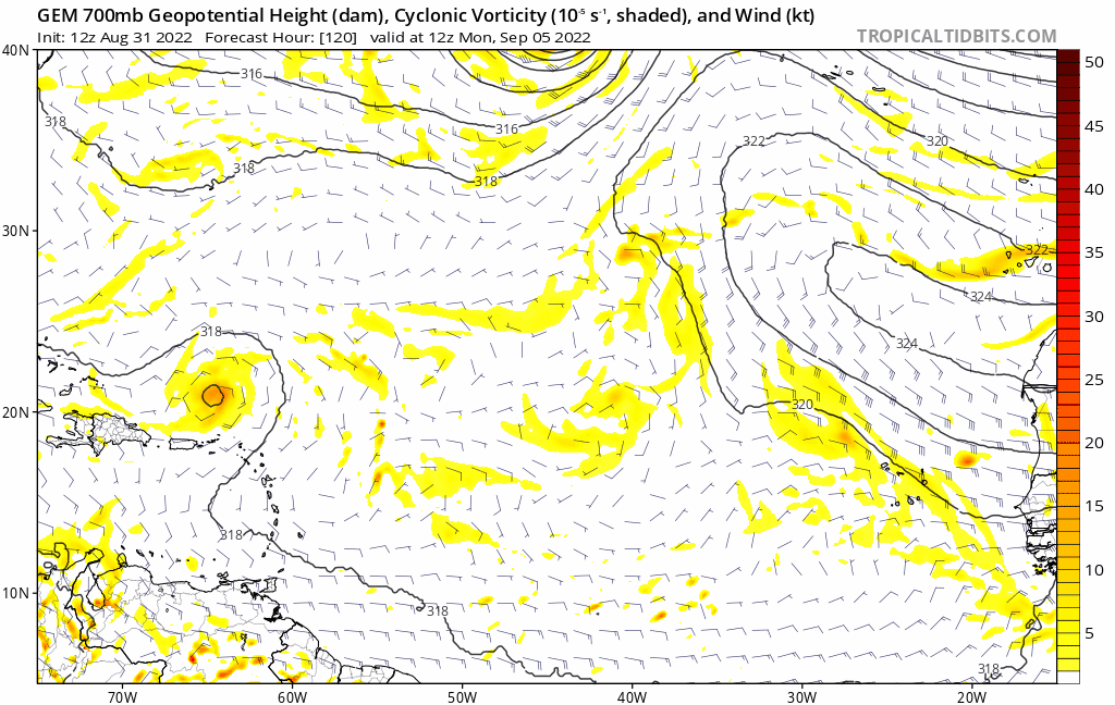
https://i.postimg.cc/vTqG84tP/cmc.gif
The CMC is normally conservative, let's see if it's just a model bluff or a possible storm down the road.
0 likes
Bill 2015 & Beta 2020
Winter 2020-2021
All observations are in Tecumseh, OK unless otherwise noted.
Winter posts are focused mainly for Oklahoma & Texas.
Take any of my forecasts with a grain of salt, refer to the NWS, SPC, and NHC for official information
Never say Never with weather! Because ANYTHING is possible!
Winter 2020-2021
All observations are in Tecumseh, OK unless otherwise noted.
Winter posts are focused mainly for Oklahoma & Texas.
Take any of my forecasts with a grain of salt, refer to the NWS, SPC, and NHC for official information
Never say Never with weather! Because ANYTHING is possible!
-
Meteorcane
- Category 2
- Posts: 559
- Joined: Thu Jul 21, 2011 6:49 am
- Location: North Platte Nebraska
Re: 2022 Global Model Runs Discussion (Out thru day 16)
SFLcane wrote: monsoon trough losing influence potentially? The do roll of pretty clean.
It does appear that way, to use a very non-technical terms "a cleaner splash down" and quicker detachment from the monsoon trough, at least in the extended models (so some grain of salt).
3 likes
-
Iceresistance
- Category 5
- Posts: 9441
- Age: 22
- Joined: Sat Oct 10, 2020 9:45 am
- Location: Tecumseh, OK/Norman, OK
Re: 2022 Global Model Runs Discussion (Out thru day 16)
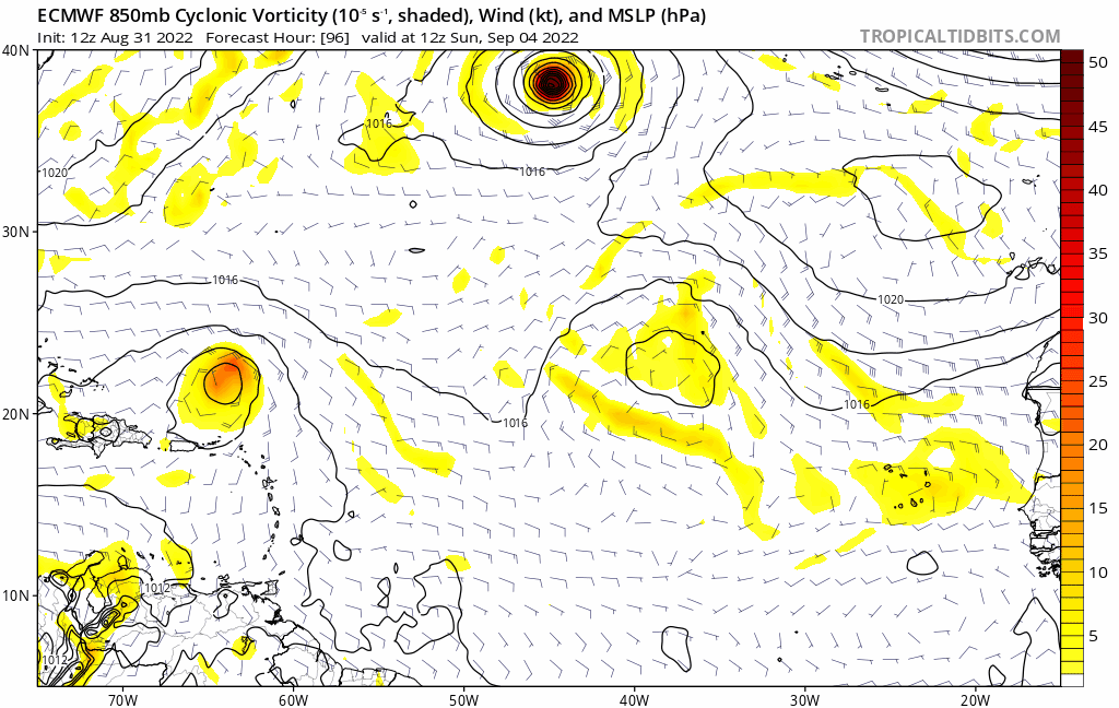
SFLcane wrote:https://i.postimg.cc/yxqz1WWK/ecm33.gif
This may become concerning now that the Euro and Canadian are consistent with the 9/6 MDR Hurricane.
0 likes
Bill 2015 & Beta 2020
Winter 2020-2021
All observations are in Tecumseh, OK unless otherwise noted.
Winter posts are focused mainly for Oklahoma & Texas.
Take any of my forecasts with a grain of salt, refer to the NWS, SPC, and NHC for official information
Never say Never with weather! Because ANYTHING is possible!
Winter 2020-2021
All observations are in Tecumseh, OK unless otherwise noted.
Winter posts are focused mainly for Oklahoma & Texas.
Take any of my forecasts with a grain of salt, refer to the NWS, SPC, and NHC for official information
Never say Never with weather! Because ANYTHING is possible!
Re: 2022 Global Model Runs Discussion (Out thru day 16)
SFLcane wrote:https://i.postimg.cc/yxqz1WWK/ecm33.gif
Yep that storm in the MDR looks like will be the one to watch. Look at that nice high pressure north of it expanding west in tandem with it.
2 likes
-
cycloneye

- Admin

- Posts: 148719
- Age: 69
- Joined: Thu Oct 10, 2002 10:54 am
- Location: San Juan, Puerto Rico
Re: 2022 Global Model Runs Discussion (Out thru day 16)

0 likes
Visit the Caribbean-Central America Weather Thread where you can find at first post web cams,radars
and observations from Caribbean basin members Click Here
and observations from Caribbean basin members Click Here
-
Meteorcane
- Category 2
- Posts: 559
- Joined: Thu Jul 21, 2011 6:49 am
- Location: North Platte Nebraska
Re: 2022 Global Model Runs Discussion (Out thru day 16)
caneseddy wrote:SFLcane wrote:https://i.postimg.cc/yxqz1WWK/ecm33.gif
Yep that storm in the MDR looks like will be the one to watch. Look at that nice high pressure north of it expanding west in tandem with it.
Agreed, had pretty good support from the 00Z EPS too, would hypothesize it will get some from the 12Z. If the ridge to its north does move in tandem with it that would both limit shear, and probably limit at least mid-latitude dry air intrusions (although possibly some SAL from riding the southern flank of the ridge could still make it in the vicinity of the circulation). Given the ridge to its north the system would obviously track W/WNW through 240... beyond that I have no idea honestly as the weakness induced by 91L/Future Danielle and general troughing over the east coast may be present in the west-central Atlantic... although at the same time the ridge could keep expanding westward. Unfortunately the ensemble mean fields don't offer much clarity as to the synoptic pattern at this time, as any signal is quite weak (and remember there will be a typhoon recurvature in the WPAC that will start to have teleconnections in the Atlantic by this time, which aren't going to be properly handled by models anyway).
Still that is a lot of conjecture on my part about a wave that won't even move off of Africa for another 5 days lol, I think the general synoptic environment being favorable in the Central/Eastern Atlantic is pretty clear though so I will give it a little more credence than a typical late range "model fantasy storm"
Last edited by Meteorcane on Wed Aug 31, 2022 2:07 pm, edited 1 time in total.
2 likes
Re: 2022 Global Model Runs Discussion (Out thru day 16)
It seems at the end of the run, there looks to be a bit of an opening left where 91L is recurving but doesn't seem like it will enough to send this one out that way and you can see where it looks like the high pressure on top of this disturbance is rushing to close the gap, which if it does may signify trouble for the CONUS.
Interesting week ahead...
2 likes
Who is online
Users browsing this forum: No registered users and 81 guests