ATL: EARL - Post-Tropical - Discussion

Moderator: S2k Moderators

Message
Author
User avatar
cycloneye
Admin
Admin
Posts: 145295
Age: 68
Joined: Thu Oct 10, 2002 10:54 am
Location: San Juan, Puerto Rico

Re: ATL: INVEST 91L - Discussion

#161 Postby cycloneye » Mon Aug 29, 2022 7:00 am

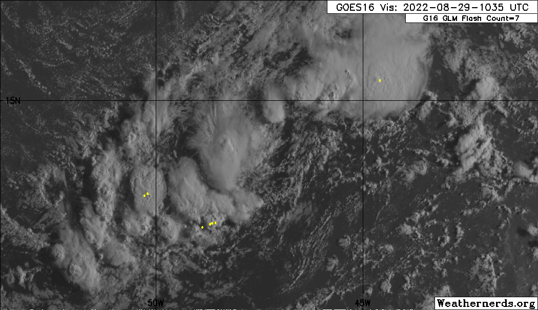
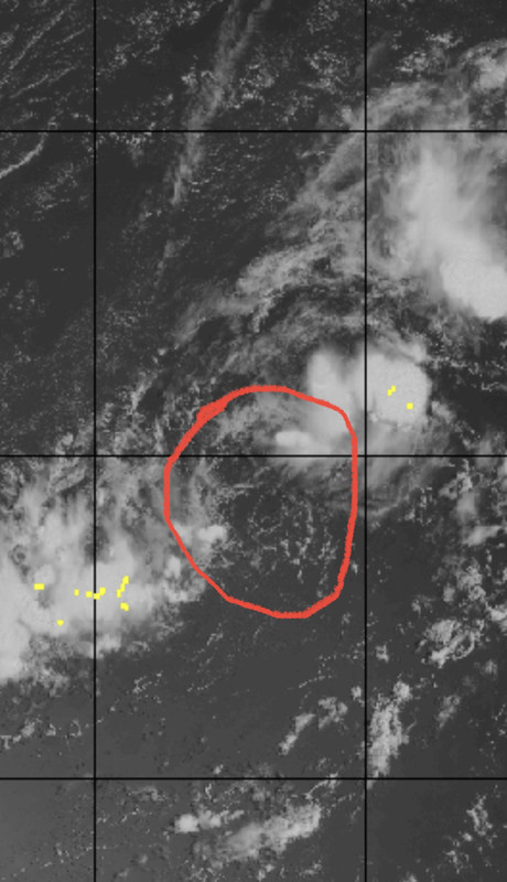
Central Tropical Atlantic:
A broad area of low pressure over the central tropical Atlantic
is producing a large area of disorganized cloudiness and showers.
Although environmental conditions are only marginally favorable,
some gradual development of this system is expected over the next
several days and a tropical depression is likely to form later this
week. The disturbance is forecast to move slowly toward the west
and then west-northwest at 5 to 10 mph, toward the adjacent waters
of the northern Leeward Islands. Additional information on this
system can be found in high seas forecasts issued by the National
Weather Service.
* Formation chance through 48 hours...medium...50 percent.
* Formation chance through 5 days...high...80 percent.
0 likes   
Visit the Caribbean-Central America Weather Thread where you can find at first post web cams,radars
and observations from Caribbean basin members Click Here

User avatar
cycloneye
Admin
Admin
Posts: 145295
Age: 68
Joined: Thu Oct 10, 2002 10:54 am
Location: San Juan, Puerto Rico

Re: ATL: INVEST 91L - Discussion

#162 Postby cycloneye » Mon Aug 29, 2022 7:35 am

AL, 91, 2022082912, , BEST, 0, 147N, 467W, 30, 1007, DB


Image
1 likes   
Visit the Caribbean-Central America Weather Thread where you can find at first post web cams,radars
and observations from Caribbean basin members Click Here

User avatar
skyline385
Category 5
Category 5
Posts: 2728
Age: 35
Joined: Wed Aug 26, 2020 11:15 pm
Location: Houston TX

Re: ATL: INVEST 91L - Discussion

#163 Postby skyline385 » Mon Aug 29, 2022 7:36 am

Going to be a lot of uncertainty with this one

 https://twitter.com/JackSillin/status/1564225930373070848


0 likes   

AutoPenalti
Category 5
Category 5
Posts: 4030
Age: 29
Joined: Mon Aug 17, 2015 4:16 pm
Location: Ft. Lauderdale, Florida

Re: ATL: INVEST 91L - Discussion

#164 Postby AutoPenalti » Mon Aug 29, 2022 8:01 am

1 likes   
The posts in this forum are NOT official forecasts and should not be used as such. They are just the opinion of the poster and may or may not be backed by sound meteorological data. They are NOT endorsed by any professional institution or STORM2K. For official information, please refer to products from the NHC and NWS.


Model Runs Cheat Sheet:
GFS (5:30 AM/PM, 11:30 AM/PM)
HWRF, GFDL, UKMET, NAVGEM (6:30-8:00 AM/PM, 12:30-2:00 AM/PM)
ECMWF (1:45 AM/PM)

TCVN
is a weighted averaged

User avatar
wxman57
Moderator-Pro Met
Moderator-Pro Met
Posts: 22978
Age: 67
Joined: Sat Jun 21, 2003 8:06 pm
Location: Houston, TX (southwest)

Re: ATL: INVEST 91L - Discussion

#165 Postby wxman57 » Mon Aug 29, 2022 8:54 am

The disturbance is now butting up against an upper-level trof. Ridge to its north has weakened. Result is a slowing of its forward speed and a northward jog for a while. This should allow it to safely clear the islands of the NE Caribbean on Friday. Depending on how far north it jogs and its future forward speed, it could well turn out to sea and not impact the Bahamas or U.S. Way too early to be sure about that, though. I'm more confident it won't cause any significant impacts for the NE Caribbean, though.
10 likes   

User avatar
Iceresistance
Category 5
Category 5
Posts: 9288
Age: 21
Joined: Sat Oct 10, 2020 9:45 am
Location: Tecumseh, OK/Norman, OK

Re: ATL: INVEST 91L - Discussion

#166 Postby Iceresistance » Mon Aug 29, 2022 9:00 am

91L is extremely elongated SW to NE.
0 likes   
Bill 2015 & Beta 2020

Winter 2020-2021 :cold:

All observations are in Tecumseh, OK unless otherwise noted.

Winter posts are focused mainly for Oklahoma & Texas.

Take any of my forecasts with a grain of salt, refer to the NWS, SPC, and NHC for official information

Never say Never with weather! Because ANYTHING is possible!

User avatar
Blown Away
S2K Supporter
S2K Supporter
Posts: 10145
Joined: Wed May 26, 2004 6:17 am

Re: ATL: INVEST 91L - Discussion

#167 Postby Blown Away » Mon Aug 29, 2022 9:10 am

Image

Image

Very weak COC, but it’s chugging slowly W.
1 likes   
Hurricane Eye Experience: David 79, Irene 99, Frances 04, Jeanne 04, Wilma 05... EYE COMING MY WAY IN 2024…
Hurricane Brush Experience: Andrew 92, Erin 95, Floyd 99, Matthew 16, Irma 17, Ian 22, Nicole 22…

dexterlabio
Category 5
Category 5
Posts: 3468
Joined: Sat Oct 24, 2009 11:50 pm

Re: ATL: INVEST 91L - Discussion

#168 Postby dexterlabio » Mon Aug 29, 2022 9:42 am

skyline385 wrote:Going to be a lot of uncertainty with this one

https://twitter.com/JackSillin/status/1564225930373070848?s=20&t=6Njc5PMXD4WD8yM58KA1Ew


Ugh, three letters that I hate to see together in track forecast: C O L
0 likes   
Personal Forecast Disclaimer:
The posts in this forum are NOT official forecast and should not be used as such. They are just the opinion of the poster and may or may not be backed by sound meteorological data. They are NOT endorsed by any professional institution or storm2k.org. For official information, please refer to the NHC and NWS products.

User avatar
AnnularCane
S2K Supporter
S2K Supporter
Posts: 2862
Joined: Thu Jun 08, 2006 9:18 am
Location: Wytheville, VA

Re: ATL: INVEST 91L - Discussion

#169 Postby AnnularCane » Mon Aug 29, 2022 11:02 am

Okay, I gotta know. What's a col? (I think I thought that was a typo. :lol: )
1 likes   
"But it never rained rain. It never snowed snow. And it never blew just wind. It rained things like soup and juice. It snowed mashed potatoes and green peas. And sometimes the wind blew in storms of hamburgers." -- Judi Barrett, Cloudy with a Chance of Meatballs

User avatar
LadyBug72
Tropical Storm
Tropical Storm
Posts: 118
Joined: Mon Jun 01, 2020 3:39 pm
Location: about 20 miles from Galveston, Tx

Re: ATL: INVEST 91L - Discussion

#170 Postby LadyBug72 » Mon Aug 29, 2022 11:10 am

AnnularCane wrote:Okay, I gotta know. What's a col? (I think I thought that was a typo. :lol: )


In meteorology, the point of intersection of a trough and a ridge in the pressure pattern of a weather map. It is the point of relatively lowest pressure between two highs and the point of relatively highest pressure between two lows.
3 likes   
Formerly known as the user: Nikki

Alicia 83, Allison 01, Rita 05, Ike 08, Harvey 17, Nicholas 21, Coastal Texas Derecho 24, Beryl 24

User avatar
Spacecoast
Category 2
Category 2
Posts: 758
Joined: Thu Aug 31, 2017 2:03 pm

Re: ATL: INVEST 91L - Discussion

#171 Postby Spacecoast » Mon Aug 29, 2022 11:24 am

TVCN trending N...
Image
1 likes   

Sciencerocks
Category 5
Category 5
Posts: 9155
Age: 39
Joined: Thu Jul 06, 2017 1:51 am

Re: ATL: INVEST 91L - Discussion

#172 Postby Sciencerocks » Mon Aug 29, 2022 11:29 am

Image
1 likes   

User avatar
skyline385
Category 5
Category 5
Posts: 2728
Age: 35
Joined: Wed Aug 26, 2020 11:15 pm
Location: Houston TX

Re: ATL: INVEST 91L - Discussion

#173 Postby skyline385 » Mon Aug 29, 2022 11:30 am

Spacecoast wrote:TVCN trending N...
Image

All the models have been trending north so yea kinda makes sense


Sent from my iPhone using Tapatalk
0 likes   

User avatar
Kingarabian
S2K Supporter
S2K Supporter
Posts: 15980
Joined: Sat Aug 08, 2009 3:06 am
Location: Honolulu, Hawaii

Re: ATL: INVEST 91L - Discussion

#174 Postby Kingarabian » Mon Aug 29, 2022 11:39 am

Probable track implications if the system fails to consolidate to the north and the convection to the south remains the strongest and ends up taking over.

Model forecasts show the center consolidating on the north side of this mess. That's still uncertain because the conditions ahead of it over the next 48-72 hours are pretty hostile.
Last edited by Kingarabian on Mon Aug 29, 2022 11:46 am, edited 1 time in total.
3 likes   
RIP Kobe Bryant

User avatar
Teban54
Category 5
Category 5
Posts: 3204
Joined: Sat May 19, 2018 1:19 pm

Re: ATL: INVEST 91L - Discussion

#175 Postby Teban54 » Mon Aug 29, 2022 11:41 am

You can clearly feel the dropoff in activity here when it doesn't appear to be a FL threat :lol:

Personally, I'm not jumping on board until the system clears LA to the north.
0 likes   

User avatar
skyline385
Category 5
Category 5
Posts: 2728
Age: 35
Joined: Wed Aug 26, 2020 11:15 pm
Location: Houston TX

Re: ATL: INVEST 91L - Discussion

#176 Postby skyline385 » Mon Aug 29, 2022 11:52 am

Teban54 wrote:You can clearly feel the dropoff in activity here when it doesn't appear to be a FL threat :lol:

Personally, I'm not jumping on board until the system clears LA to the north.

It’s not about the FL threat, 91L has been struggling for two days now and will continue to do so for a couple more atleast. Not much to talk about when we don’t even know where the center is going to be.

Meanwhile, WPAC is flexing again with another gorgeous monster cane.


Sent from my iPhone using Tapatalk
0 likes   

User avatar
sunnyday
Category 5
Category 5
Posts: 1590
Joined: Thu Sep 04, 2003 8:16 pm

Re: ATL: INVEST 91L - Discussion

#177 Postby sunnyday » Mon Aug 29, 2022 11:52 am

What is c o l ? Thank you
0 likes   

wx98
Category 5
Category 5
Posts: 1383
Joined: Sat Aug 25, 2018 9:24 pm

Re: ATL: INVEST 91L - Discussion

#178 Postby wx98 » Mon Aug 29, 2022 12:00 pm

sunnyday wrote:What is c o l ? Thank you


Per wiki:
A col, also called saddle point or neutral point, is in meteorology, the point of intersection of a trough and a ridge in the pressure pattern of a weather map.
0 likes   

User avatar
sunnyday
Category 5
Category 5
Posts: 1590
Joined: Thu Sep 04, 2003 8:16 pm

Re: ATL: INVEST 91L - Discussion

#179 Postby sunnyday » Mon Aug 29, 2022 12:01 pm

Please disregard my question about c o l. I see now that someone else had already asked. I apologize.
2 likes   

AutoPenalti
Category 5
Category 5
Posts: 4030
Age: 29
Joined: Mon Aug 17, 2015 4:16 pm
Location: Ft. Lauderdale, Florida

Re: ATL: INVEST 91L - Discussion

#180 Postby AutoPenalti » Mon Aug 29, 2022 12:07 pm

Modeling tends to improve YoY and seeing the trend starting to cave into a more OTS scenario (other then Bermuda) kills the hype for sure.
0 likes   
The posts in this forum are NOT official forecasts and should not be used as such. They are just the opinion of the poster and may or may not be backed by sound meteorological data. They are NOT endorsed by any professional institution or STORM2K. For official information, please refer to products from the NHC and NWS.


Model Runs Cheat Sheet:
GFS (5:30 AM/PM, 11:30 AM/PM)
HWRF, GFDL, UKMET, NAVGEM (6:30-8:00 AM/PM, 12:30-2:00 AM/PM)
ECMWF (1:45 AM/PM)

TCVN
is a weighted averaged


Return to “2022”

Who is online

Users browsing this forum: No registered users and 9 guests