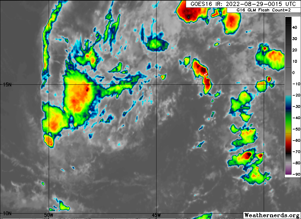
Spacecoast wrote:https://i.ibb.co/RTrPR45/loop.gif
Is a mess right now.
Moderator: S2k Moderators


Spacecoast wrote:https://i.ibb.co/RTrPR45/loop.gif


cycloneye wrote:Spacecoast wrote:https://i.ibb.co/RTrPR45/loop.gif
Is a mess right now.


SFLcane wrote:Wouldn’t be surprised if development odds are lowered later tonight.
SFLcane wrote:Wouldn’t be surprised if development odds are lowered later tonight.
Category5Kaiju wrote:SFLcane wrote:Wouldn’t be surprised if development odds are lowered later tonight.
Not personally sure if just because it looks sloppy now (likely due to DMin, which is quite natural for many TCs in their early stages) means that this is going to be a compelling reason to lower development odds, especially considering the very strong support for this system persisting down the line.


SFLcane wrote:Wouldn’t be surprised if development odds are lowered later tonight.


ElectricStorm wrote:Seems like a typical DMIN to me, convection already starting to fire again on the north side, not really sure why some people seem to overreact every time convection wanes. There's nothing whatsoever that suggests this has any less chance at developing, which should take a few more days as expected.
NotSparta wrote:SFLcane wrote:Wouldn’t be surprised if development odds are lowered later tonight.
Why? Because it's struggling a little just as we have all been expecting for days?


chaser1 wrote:Hurricaneman wrote:Nimbus wrote:
It has made the jump north and may track almost due west until the ridge weakens Wednesday.
I had it about half a degree further north near 15N when it crosses -45 so am not very happy but it should find a weakness. The models will have something to initialize on now if the models still evolve cause and effect serially the output will have a lower error rate now.
Due to being south of where the models expected might be a threat to clip the northern lesser Antilles more than expected
That's a good point and depending on speed of forward motion, could alter future model recurve forecast to potentially progress far enough to the west toward Florida and the GOM at a time where SE CONUS ridging remains quite strong. Having said all that though, I tend to agree with Blown Away and NonSparta from about a page back. In spite of improving appearance which might well continue through today, I'd be gun-shy to tag this a TD quite yet especially minus any solid banding quite yet. Moreso, it's relatively small center within the broader elongated axis continues to suggest to me that a lack of really moist inflow is working against maintaining and increasing a significant degree of convection which in turn might better aid ongoing vertical development through a still relatively dry mid-level. Present shear charts suggest 91L might be threading a needle at the moment, but I would lean toward (at least a temporary) decrease in organization by later tonight or tomorrow.

Users browsing this forum: No registered users and 15 guests


