
ATL: Ex INVEST 90L - Discussion
Moderator: S2k Moderators
-
skyline385

- Category 5

- Posts: 2728
- Age: 35
- Joined: Wed Aug 26, 2020 11:15 pm
- Location: Houston TX
ATL: INVEST 90L - Discussion
Not a TD btw 
Last edited by skyline385 on Sun May 22, 2022 10:16 pm, edited 1 time in total.
0 likes
-
Monsoonjr99
- Tropical Storm

- Posts: 210
- Age: 26
- Joined: Fri Sep 21, 2018 11:22 pm
- Location: Inland Empire, SoCal
Re: ATL: INVEST 90L - Discussion
The radar does look suspicious but this system just lacks the organized convection to be called a TC.
3 likes
The posts in this forum are NOT official forecasts and should not be used as such. They are just the opinion of the poster and may or may not be backed by sound meteorological data. They are NOT endorsed by any professional institution or STORM2K. For official information, please refer to products from the NHC and NWS.
Some Californian who codes things and tracks weather.
Kay '22, Hilary '23
-
InfernoFlameCat

- Category 5
- Posts: 2127
- Age: 22
- Joined: Mon Dec 14, 2020 10:52 am
- Location: Buford, GA
Re: ATL: INVEST 90L - Discussion
Danny should not have been named a tc if this thing isn't
2 likes
I am by no means a professional. DO NOT look at my forecasts for official information or make decisions based on what I post.
Goal: to become a registered expert over tropical and subtropical cyclones.
Goal: to become a registered expert over tropical and subtropical cyclones.
-
skyline385
- Category 5
- Posts: 2728
- Age: 35
- Joined: Wed Aug 26, 2020 11:15 pm
- Location: Houston TX
-
MGC

- S2K Supporter

- Posts: 5940
- Joined: Sun Mar 23, 2003 9:05 pm
- Location: Pass Christian MS, or what is left.
Re: ATL: INVEST 90L - Discussion
90L is lacking organized convection to be upgraded to a TD. Close but no cigar......MGC
1 likes
-
InfernoFlameCat
- Category 5
- Posts: 2127
- Age: 22
- Joined: Mon Dec 14, 2020 10:52 am
- Location: Buford, GA
Re: ATL: INVEST 90L - Discussion
90L has made Landfall!
0 likes
I am by no means a professional. DO NOT look at my forecasts for official information or make decisions based on what I post.
Goal: to become a registered expert over tropical and subtropical cyclones.
Goal: to become a registered expert over tropical and subtropical cyclones.
-
skyline385
- Category 5
- Posts: 2728
- Age: 35
- Joined: Wed Aug 26, 2020 11:15 pm
- Location: Houston TX
Re: ATL: INVEST 90L - Discussion
MGC wrote:90L is lacking organized convection to be upgraded to a TD. Close but no cigar......MGC
https://twitter.com/webberweather/status/1528583483186192384
0 likes


-
Sciencerocks
- Category 5
- Posts: 10186
- Age: 40
- Joined: Thu Jul 06, 2017 1:51 am
Re: ATL: INVEST 90L - Discussion
Tropical storm.  I'd be shocked if that isn't enough for post-season.
0 likes
-
Sciencerocks
- Category 5
- Posts: 10186
- Age: 40
- Joined: Thu Jul 06, 2017 1:51 am
-
AJC3

- Admin

- Posts: 4156
- Age: 62
- Joined: Tue Aug 31, 2004 7:04 pm
- Location: Ballston Spa, New York
- Contact:
Re: ATL: INVEST 90L - Discussion
Sciencerocks wrote:Tropical storm.
To the contrary, I'd be very surprised if this were to be upgraded post-season.
Bascially what occurred in this case was development of a southward moving MCC or MCS with peristent deep convection over the central GOMEX, which spawned a remnant MCV. The system came to a screeching halt, did a "180" and began lifting rapidly northward. While the MCV was burrowing down toward the surface, its forward speed was also increasing, which delayed the onset of a completely closed LLC (as you often see when a T-wave lacks west winds on its south side due to its fast westward motion). The appearance of a tightening spiral on radar/satellite preceded a closed ground-relative LLC by several hours - remember, when peeps are looking at a time lapse of a fast moving system, their eyes are following along with the vorticity center, which often times creates the appearance of a closed LLC, when its not quite there yet. And even you have a good scatteromter pass, it will often have trouble resolving a feature this small.
Based on that last ASCAT pass which was posted, and surface METARs near the coast, there does appear to have been a very short window where a very small LLC closed off from about 00Z (maybe a bit earlier) up until landfall. However by that time, convection near the center was shallow and sparse/dissipating, with a band of deeper convection to its east.
In sum, this system's well-wefined mid level vortex (MCV) ikely reached the surface just before landfall, but whatever closed LLC existed was brief (over water anyway), small, and lacked the prerequisite central deep convection during that short period of time to be classified. It simply ran out of time and space.
Another interesting point...while I haven't pored over all the surface obs yet, the central pressure of this small vortex may never have gotten below the standard ATM SLP of 1013.25MB, being embedded within a large surface high. IIRC there was a past discussion on here about classified systems having the highest MCPs, however I can't recall which system holds the record, or its MCP.
9 likes


Re: ATL: INVEST 90L - Discussion
InfernoFlameCat wrote:Can someone explain to me why this is not a tropical cyclone?
Didn’t sustain deep convection over the center for long enough. One of the criteria for classification as a TC is sustaining said deep convection over the LLC for ~12 hours. Except for a brief period yesterday evening, this was a naked swirl. NHC made the right call imo.
3 likes
Re: ATL: INVEST 90L - Discussion
Sciencerocks wrote:Tropical storm.
Once again, very little deep convection associated with the center barring a brief period of bursting last evening. If every invest which acted like this was classified, we’d see 30+ storms in many seasons.
3 likes
-
InfernoFlameCat
- Category 5
- Posts: 2127
- Age: 22
- Joined: Mon Dec 14, 2020 10:52 am
- Location: Buford, GA
Re: ATL: INVEST 90L - Discussion
I disagree, it appears to have maintained itself well inland and appears to still be a tropical cyclone at this point in time. It’s holding together longer than some other recent slobs that made landfall, indicative of a vigorous surface low.
1 likes
I am by no means a professional. DO NOT look at my forecasts for official information or make decisions based on what I post.
Goal: to become a registered expert over tropical and subtropical cyclones.
Goal: to become a registered expert over tropical and subtropical cyclones.
-
cycloneye

- Admin
- Posts: 149550
- Age: 69
- Joined: Thu Oct 10, 2002 10:54 am
- Location: San Juan, Puerto Rico
Re: ATL: INVEST 90L - Discussion
Tropical Weather Outlook
NWS National Hurricane Center Miami FL
800 AM EDT Mon May 23 2022
For the North Atlantic...Caribbean Sea and the Gulf of Mexico:
1. Southeastern United States:
An area of low pressure moved inland overnight along the
north-central Gulf of Mexico coast, and is now located over
south-central Alabama. The low is expected to continue to move
over land today, and tropical cyclone development is not expected.
However, locally heavy rains associated with this system will
continue to spread northeastward across portions of the
southeastern United States over the next day or so. Additional
information on the rainfall and flooding potential can be found in
products issued by your local National Weather Service Forecast
Office and Excessive Rainfall Outlooks issued by the Weather
Prediction Center.
* Formation chance through 48 hours...low...near 0 percent.
* Formation chance through 5 days...low...near 0 percent.
Forecaster Pasch
0 likes
Visit the Caribbean-Central America Weather Thread where you can find at first post web cams,radars
and observations from Caribbean basin members Click Here
and observations from Caribbean basin members Click Here
-
cycloneye
- Admin
- Posts: 149550
- Age: 69
- Joined: Thu Oct 10, 2002 10:54 am
- Location: San Juan, Puerto Rico
Re: ATL: INVEST 90L - Discussion
They could upgrade at post-season to unnamed storm if the data they gather is solid.
3 likes
Visit the Caribbean-Central America Weather Thread where you can find at first post web cams,radars
and observations from Caribbean basin members Click Here
and observations from Caribbean basin members Click Here
Re: ATL: INVEST 90L - Discussion
InfernoFlameCat wrote:I disagree, it appears to have maintained itself well inland and appears to still be a tropical cyclone at this point in time. It’s holding together longer than some other recent slobs that made landfall, indicative of a vigorous surface low.
After seeing the data indicating significant pressure falls (down to potentially 1002 mb if verified!) in the landfall zone as well as its ability to hold itself together over land, I have walked back my earlier claims. Likely was a TC (albeit a very brief one) though not sure if it'll be upgraded in post-season.
https://twitter.com/SteveWAFB/status/15 ... 8429713408
4 likes
-
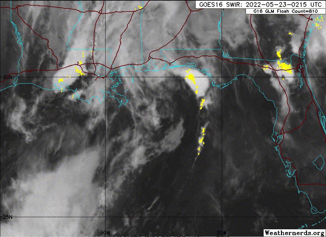
skyline385
- Category 5
- Posts: 2728
- Age: 35
- Joined: Wed Aug 26, 2020 11:15 pm
- Location: Houston TX
Re: ATL: Ex INVEST 90L - Discussion
Still looking pretty good with some some circulation visible

0 likes
-
AJC3
- Admin
- Posts: 4156
- Age: 62
- Joined: Tue Aug 31, 2004 7:04 pm
- Location: Ballston Spa, New York
- Contact:
Re: ATL: INVEST 90L - Discussion
ThomasW wrote:InfernoFlameCat wrote:I disagree, it appears to have maintained itself well inland and appears to still be a tropical cyclone at this point in time. It’s holding together longer than some other recent slobs that made landfall, indicative of a vigorous surface low.
After seeing the data indicating significant pressure falls (down to potentially 1002 mb if verified!) in the landfall zone as well as its ability to hold itself together over land, I have walked back my earlier claims. Likely was a TC (albeit a very brief one) though not sure if it'll be upgraded in post-season.
https://twitter.com/SteveWAFB/status/15 ... 8429713408
That SLP trace doesn't look close to close to reality. It's too low well outside of the period of time the low moved across the panhandle. All the reporting stations I saw were in the 1013-1016 range along the coast at the time this weak low moved onshore. Lowest SLP recorded at KPNS this morning was 1013.3MB
3 likes
-
SconnieCane
- Category 5
- Posts: 1013
- Joined: Thu Aug 02, 2018 5:29 pm
- Location: Madison, WI
Re: ATL: Ex INVEST 90L - Discussion
This system is a good reminder of why pre-season development (or lack thereof) shouldn't be taken as a reliable seasonal indicator...if they're not subtropical in origin, a lot of them are these short-lived spinups born out of MCVs that are basically +/- 6-12 hours over water and a judgement call by the forecaster on duty whether they get classified operationally or not.
10 likes
Who is online
Users browsing this forum: No registered users and 21 guests