


I hope you all had a good start to this new year. I made this 'oddball' season prediction thread for 2022 just like I did for last year and 2020, using the Chinese Zodiac to maybe apply the 12 and 60 year cycles that exist within this astrology and see if it can shed some light on what 2022 might bring, with still almost 3 months to go before hurricane season begins! This thread is the earliest it has been so far and is both for the fun of it and also a continuing experiment to see if Chinese Astrology can actually help paint a 'big picture' idea of what a particular season could bring, if indeed there exist 12-year and 60-year zodiacal cycles that extend into the world of tropical cyclones. The full prediction for 2022, along with historical and risk area graphics can be found towards the bottom of this post.
Last year, 2021, was the Year of the Ox and it was an interesting one because it ramped up quick but met its demise just as fast! The Year of the Metal Ox, as that one was called, brought a very front-loaded season that had a strong peak season, followed by a sudden decline in activity unusually early in October. This has been a hallmark of most Ox years past, a fairly active or average early/peak season followed by an early end, that is. The Metal Ox year did overall favor a busier late season compared to the other element Ox years, but in 2021 the traits of the other Ox years seemed to play out instead, and the season died very early after having been so busy during the peak in Aug-Sep. 2021 Metal Ox also delivered one of the “analogs” (1961 Carla) with Ida hitting the GOM coast 2 weeks before Carla’s 60th anniversary landfall date and one state over (Louisiana). We did squeeze out all 21 names, but only 7 became hurricanes, with 4 of them major, making it ‘feel’ slower. Then again, anything would feel slower compared to the Metal Rat year of 2020… 30/14/7, good lord!
- 2022 is the Year of the Tiger, could it bring something different compared to these recent seasons? According to this astral wizard method, the short answer is yes!, and in a nutshell, 2022 could bring a very busy, backloaded season that features major changes with respect to the big storm tracks, putting places like Cuba, Florida and the Bahamas in the crosshairs much more than last season. This oddball zodiac cycle experiment also can give a straight answer about 2022's expected storm numbers, even this early. As of March 11, these are 2022’s potential storm totals:
20/9/4
ACE ~ 135 - 165
Now lets take a closer look at this astrology, what the Year of the Tiger means, and look at what led to these numbers…
The Chinese Zodiac

Chinese Astrology is a bit more complex than most people think, because this ancient astrology system also assigns 5 different elements (Metal, Water, Wood, Fire, Earth) to the yearly animal signs, making for a total of 60 different year combinations! This way 2020 was a Metal Rat year, 2021 a Metal Ox year, and now 2022 will be the Water Tiger year starting on February 1st! This time we get more than a new animal zodiac year, we also break the Metal cycle and enter the Water cycle. Each element cycle lasts 2 years. 2023, next year, will be the Water Rabbit year.
Here’s some history on the origin of the zodiac, for those interested, in the link below:
https://depts.washington.edu/triolive/quest/2007/TTQ07030/history.html
This ancient wisdom handed down by the Chinese is thousands of years old, and perhaps, just perhaps, it may also extend into tropical meteorology.
In a bit more scientific view, perhaps there exist recurring significant weather patterns, happening to some degree, every 12 years / 60 years around the world for some reason, including the tropics. If we take a step back, we could look and say that Chinese Astrology indicates that there are possibly 12-year and 60-year natural cycles at play, and the animal signs only make it easier to point them out. Alright, lets get into the 2022 stuff:
The year 2022 falls within the 12-year cycle the Chinese call the Year of the Tiger, and the 60-year cycle which is called the Water Tiger.
Using the 12 year cycle, we'd look at the years 2010, 1998, 1986, 1974, 1962, 1950, 1938, 1926, 1914, 1902, and so on, to get an idea of what 2022 could be like. Interestingly, the seasons in this cycle were Extremes at opposite ends, they were either very busy & destructive, or ridiculously slow and uneventful. There practically seems to be no middle ground with Tiger-year Atlantic Seasons. This could mean that Tiger years are either extremely busy or extremely slow, regardless of their element too, making them tough to forecast. Any forecast for an Average season could be very prone to busting badly in 2022, if this were the case. The busier Tiger year seasons also brought incredibly powerful & destructive hurricanes, while at the other end of the spectrum, the slow Tiger year seasons also had little impacts to boot, so the Tiger years can be like Jekyll and Hyde in nature.
It may seem like a coin-flip to see what 2022 will end up being like, although the outcome does seem to go hand in hand with the meteorological cycle of active-eras and inactive-eras (AMO), with Active-era Tiger Years bringing the very busy and destructive seasons, and the Inactive-era Tiger years bringing virtually nothing burgers. The only Active-era Tiger year season that wasn’t as severe with landfalls, although still very busy, was 2010, with several moderate Cat 2 hurricane landfalls and a borderline C3 instead of high intensity high impact majors. The year 2022 might not be as lucky, considering we will likely remain within the same AMO cycle that began in 1995, and we might witness a nasty Active-era Tiger year with high impacts, like 1998 or 1926 for example.
The sexagenary cycle (60 yr) on the other hand, does offer a little hope for a less active season, because the 2 most recent Water Tiger years were among the slower historical Tiger year seasons (1962, 1902). In my opinion however, this would just offer little hope because these two years fell during inactive-eras. The Water Tiger year of 1842 was very eventful and pretty destructive on the other hand! Odds favor Water Tiger 2022 continuing to fall within the Active 1995-Present era, so an extreme outcome towards the active and highly damaging is likelier unfortunately. 1842 could perhaps be one of the best analog years to 2022, as well as 1842 combined with either 1926, 1938, 1950, 1998 or 2010. If we do get lucky however, the seasons of 1962 & 1902 might prove to be decent analogs in the end.
I did some digging around and found the data needed to make a guess at the 2022 season. This is the first of two main parameters that I looked at this time...
The first parameter consists of 1.) the seasonal numbers in Total Tropical Storms/Hurricanes/Majors format (T/H/M) for all 'Tiger Years' since 1851 and different averages we can find with the data, 2.) the Water Tiger years alone since 1842, and 3.) the average of the last 11 seasons since the last Tiger Year, (2010 - 2021). The 3 different aspects of this parameter helped me come up with the experimental outlook for 2022.
PARAMETER 1 -
1.1 - Past Tiger Year Cycles and their seasonal numbers (T/H/M), dating back to 1851:
1851 - 1950 era:
1854 - 5/3/1
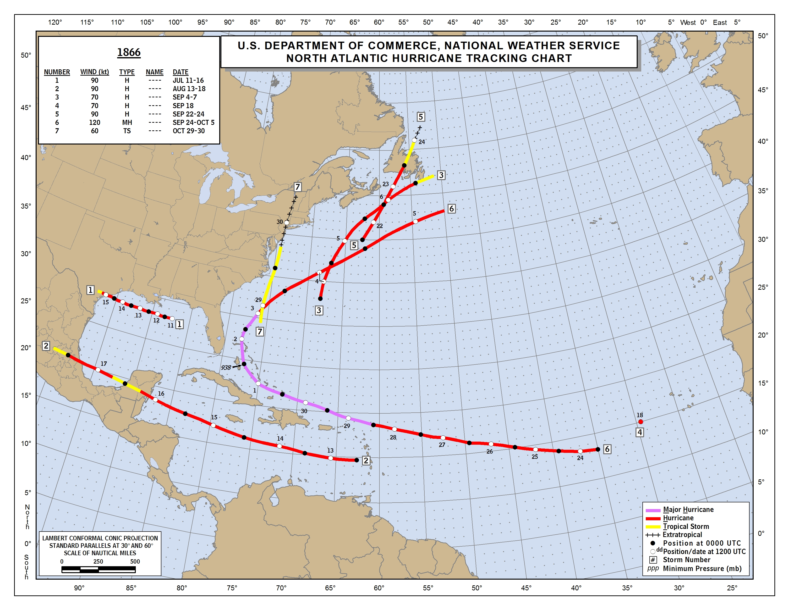
1866 - 7/6/1
1878 - 12/10/2
1890 - 4/2/1
1902 - 5/3/0
1914 - 1/0/0
1926 - 11/8/6
1938 - 9/4/2
1950 - 16/11/6
Average of these years = 7.8/5.2/2.1, when rounded = 8/5/2. The number of storms/hurricanes/majors were skewed down significantly by the seasons of 1902, 1914 & 1890, but even so the average number of hurricanes and majors still went up by 1 compared to the Ox-year averages for the same 1851-1950 era. The 8/5/2 is a fairly solid total storm count for a time when up to 6 storms may have been missed each year, according to the NHC's Christopher Landsea (reference, "Counting Atlantic Tropical Cyclones back to 1900"). There is overall a fairly average number of hurricanes for the time period, and an average major hurricane number too, BUT this resulted from averaging out the wildly varying busy and slow seasons. Tiger years really seem to be years of extremes, both highs and lows! Lets see if the more recent Tiger years were any different:
1950 - present era:
1950 – 16/11/6
1962 - 7/4/0
1974 - 11/4/2
1986 - 6/4/0
1998 - 14/10/3
2010 - 19/12/5
Average of these years = 12.2/7.5/2.7, when rounded = 12/8/3. This is significantly higher than the known 9.6/5.9/2.3 average for all seasons from 1950 to 2000. Here it seems that the Active-era Tiger years were so busy that they still skewed the averages upward despite the slow seasons in the mix. This keeps indicating that Tiger years tend to be either extremely active seasons, or very slow seasons, and are much more sensitive/dependent on the active era/inactive era cycle, the Atlantic Multi-decadal Oscillation (AMO), than other years. The words “normal” or “average” don’t seem to apply to Tiger-year Atlantic hurricane seasons, very few if any seasons were close to average. These extreme seasons swing either way up or way down in activity levels and impacts.
Active-era Tiger Years since 1926:
1926 - 11/8/6
1938 - 9/4/2
1950 - 16/11/6
1998 - 14/10/3
2010 - 19/12/5
Average of these years = 13.8/9.0/4.4, when rounded = 14/9/4. This average only takes into account the Tiger years that occurred during active eras, thus weeding out the skew from the slow-era seasons. Since Tiger years tend to be extremely busy or slow depending on the era, the active-era tiger year average since 1926 could be useful in coming up with calculations for the worst possible outcome for 2022, which gets averaged into the math used to get the outlook. This average is quite impressive too, considering it goes back to 1926.
1.2 - Water Tiger 60 Year Cycle and the seasonal numbers (T/H/M), dating back to 1842:
Switching gears a bit, this is now the Water Tiger year average, taking only 1842, 1902 and 1962 into account because of a lack of data in the years 1782, 1722 and so on. The 1842 season was active and destructive enough that it enabled it to have a decent storm count, due to all the storm reports. The years 1902 and 1962 are within the 1851-present database too, and these two seasons were a stark contrast to 1842, being very slow and uneventful seasons.
1842 – 8/6/2
1902 - 5/3/0
1962 - 7/4/0
Average = 6.7/4.3/0.3 = when rounded = 7/4/0. This is substantially lower than the old 1950 - 2000 average of 9.6/5.9/2.3 particularly in the total number of storms and majors. 2022 could have a lower number of named storms and hurricanes/majors if this Water Tiger average verifies. This right here would perhaps be the most optimistic case for this season. It is important to note however that the AMO was not the same in 1902/1962 as it is now, so the active 1842 season would probably be the best analog out of the three for 2022.
1.3 - The New Seasonal Average since the last Tiger Year, 2010:
Times are changing however, and it's possible to catch more named storms with current methods than ever before. The newest 30-year average from 1991-2020 is: 14.4/7.2/3.2. Higher than the previous averages to say the least.
In fact, in order to attempt to guess at how many 2022 will bring, it could be an even better idea to also look at the seasons since 2010, which was the previous Tiger Year and also around the time that modern technology helped us detect even more named storms;
the 2010-2021 seasons which went like this:
2010: 19/12/5
2011: 19/7/4
2012: 19/10/2
2013: 14/2/0
2014: 8/6/2
2015: 11/4/2
2016: 15/7/4
2017: 17/10/6
2018: 15/8/2
2019: 18/6/3
2020: 30/14/7
2021: 21/7/4
2010 - 2021 Average: 17.2/7.8/3.4 = 17/8/3. This to me is perhaps the average we should compare to this season and past Tiger Year hurricane seasons.
*Combining the 3 parts of the parameter above, we have a situation in which 2022 represents a balance between the slower Water Tiger years against the active-era Tiger years, combined with the average of the last 11 years, leading to this outlook below:
Outlook: 2022 - 20/9/4
ACE Range = 135 - 165
Numbers like these say 2022 might be in the league of these 5 recent Atlantic Hurricane Seasons ... 2010, 2011, 2012, 2019, 2021. Out of these seasons in the last decade, 2012 & 2021 are perhaps the closest representation of what 2022 may bring, number-wise, with those seasons having 19/10/2 and 21/7/4 respectively. The 2022 Hurricane Season may dish out many named storms, but will likely produce only a few majors, yet the takeaway is that one or 2 of those majors will perhaps be monstrous and very memorable (like Andrew). As for Tiger years, 2022 might be more similar to 1842, 1926, 1950, 1998 & 2010, and probably more accurately, a combination of those 4 tiger years. This season will likely try to balance out the slower 60-year cycle, Water Tiger, influence with the current multi-decadal active cycle of tropical activity, along with the tendency for extreme levels of activity seen during the 12-year cycle known as year of Tiger. 2022 really is perhaps the trickiest year I’ve tried to guess using this oddball method so far! (so this prediction could very well bust badly, lol)
Calculations that led to this estimate:
1) - 1950 – 2000 avg Compared with Tiger year Average 1950 – 2010, Multiplied by 1991 – 2020 Avg = Likely 2022 outcome based on old & new ratios:
- Tiger Yr Avg (1950 – 2010) = 12.2/7.5/2.7; 1950-2000 Avg = 9.6/5.9/2.3 = this yields Tiger Year percentages VS the 1950-2000 normal = (12.2, 7.5, 2.7) / (9.6, 5.9, 2.3) X 100 = 127.1%/127.1%/117.4%.
- 1991 - 2020 Avg = 14.4/7.2/3.2
Math = Tiger Year percentages compared to normal (127.1%/127.1%/117.4%) X 1991 – 2020 Avg (14.4/7.2/3.2) = 18.3/9.2/3.8 = 18/9/4. This is a reasonable, middle of the pack, outcome for 2022.
2) - 1950 – 2000 Climatological Avg Compared with Active-era Tiger year Average since 1926, Multiplied by 2010 – 2021 avg = Reasonable worst possible outcome for 2022.
- Active-era Tiger Yr Average since 1926 = 13.8/9.0/4.4; 1950-2000 Avg = 9.6/5.9/2.3 = yields Active-era Tiger Year percentages VS the 1950-2000 normal = (13.8, 9.0, 4.4) / (9.6, 5.9, 2.3) X 100 = 143.8%/152.5%/191.3%.
- 2010 – 2021 Avg = 17.2/7.8/3.4
Math = (143.8%/152.5%/191.3%) X (17.2/7.8/3.4) = (24.7/11.9/6.5) = 25/12/7. This is a reasonable worst-case outcome for 2022, assuming the strong averages of Active-era Tiger years get mingled with the already active 2010-2021 average.
3) Water Tiger avg (1842, 1902, 1962) + (1991 – 2020 avg) / 2 = Reasonable best 2022 outcome based on the average of the past 3 Water Tiger years.
(6.7/4.3/0.3) + (14.4/7.2/3.2) / 2 = 10.6/5.8/1.8 = 11/6/2. This is a reasonable low-end outcome for 2022.
*Average the Three Calculations for a 2022 approximation*...
Math = (18/9/4) + (25/12/7) + (11/6/2) / 3 = 18.0/9.0/4.3 = 18/9/4.
In many recent years, there seems to be about an extra 1 to 3 weak named storms that form and kick-up the final storm tallies, therefore adding about 2 extra names to the calculated 18/9/4 may be wise… so 20/9/4. may be the best prediction numbers to go with overall. This way we can account for 2 extra weak short-lived storms that could form, including those pre-season storms that can form in May. I'm more confident on the hurricane and major hurricane numbers, since the weak systems could easily skew the named storm numbers way upward, but the math based on Tiger years says about 18-25 named storms are likeliest for this kind of season in this day and age. If for some reason we revert to the inactive-era this year, a season tally closer to the 11/6/2 would be likelier… but this is the least likely option at the moment.
Now that you guys saw my prediction numbers for 2022 based on parameter 1, lets have a look at Parameter 2, the one that may shed some light on who may get hit by 2022's big ones and maybe even when...
PARAMETER 2 -
Significant (Cat 2+) Landfalls / Impacts during the Tiger Year Cycle:
Lets take a look back 300 years if possible for a little more accuracy, like we did for last year's outlook.
Before 1851:
~ 1722 Water Tiger:
Aug to Sep - Strong Hurricane, likely Cat 3+, strikes Port Royal, jamaica during Late August before continuing into the Caribbean through early September. A 16 ft storm surge was reported in Jamaica from that hurricane. Sept 11-25: Another storm, The Great Louisiana Hurricane of 1722, tracks through the Lesser Antilles around the 11th, before slamming into Louisiana around 9/24 as a powerful hurricane, causing major destruction.
~ 1734 Wood Tiger:
Sep - Strong hurricane strikes Jamaica causing ‘great damage’, exact intensity unknown but probably Cat 2+.
~ 1758 Earth Tiger:
Nov – Hurricane strikes St. Kitts from the west on Nov 10, killing 200 people. The storm could have been a Cat 2+.
~ 1782 Water Tiger:
Sep – The Central Atlantic Hurricane of 1782, Interestingly this was not a landfalling hurricane, but its impacts were severe enough to include it in this list. The powerful hurricane struck Admiral Graves’ fleet on Sept 17 in the Central Atlantic, killing 3,500 sailors. The hurricane was likely a major.
~ 1794 Wood Tiger:
Aug – Strong hurricane struck Havana, Cuba on Aug 25, killing 100+ people, likely as a Cat 2+. The storm went on to hit the Florida Keys and Louisiana afterward through Aug 31.
~ 1806 Fire Tiger:
Aug – Great Coastal Hurricane of 1806, passed near Lesser Antilles on Aug 17, delivered a major strike on the Carolinas while staying just offshore or making landfall in eastern NC. Likely a Cat 2+.
Sep – Two hurricanes struck Dominica on 9/11 & 9/20, both killing over 100 people. Hurricane San Vicente, the one of Sep 11, claimed 465 lives, and later went on to hit Mississippi on 9/18. Both storms were likely Cat 2+.
~ 1818 Earth Tiger:
Sep – Likely Category 3 hurricane made landfall near Galveston, TX Sept 13, causing major damage. Only 6 homes were left standing in Galveston. The hurricane reportedly also destroyed the pirate Jean Lafitte’s settlement at Galveston, sinking or wrecking at least 4 of his ships. The storm surge was also reportedly very severe.
~ 1842 Water Tiger:
July – Powerful hurricane, likely Cat 2+, battered the Carolina coast while passing just east of Cape Hatteras, causing major structural damage and wrecking 40 ships. The storm then kept heaidng northward and made landfall in Norfolk Virginia, bringing major flooding to the Mid-Atlantic.
Sep – Antje’s Hurricane, a powerful cape verde system, was first spotted over the Leewards before it crashed into the Bahamas in early September, yielding ‘widespread destruction’. The likely major Cat 3+ hurricane then went on to traverse the Florida Straits, causing severe damage in both northern Cuba and the lower Florida Keys. The hurricane then went on to hit northern Mexico on Sept 8 between Matamoros and Tampico. This storm had an unusual westward trajectory throughout its entire life.
Oct – Major hurricane strikes Florida’s upper gulf coast near Cedar Key with a severe storm surge on October 5, and causes extensive damage in Tallahassee, before continuing up the Southeast US coast delivering strong winds and flooding tides at Savannah and Charleston.
1851 - Present:
~ 1854 Wood Tiger:
Sep – Sep 7-12: Major hurricane affects Freeport Bahamas before heading NNW to make a Cat 3 landfall at the Georgia/SC border, causing 26 deaths and extensive damage. This storm was calculated to have had a peak of 125 mph. Sep 18-20: Category 2 hurricane hits Matagorda, Texas causing significant impacts.
~ 1866 Fire Tiger:
July – Category 2 hurricane strikes Matagorda Texas again, almost like a dejavu from 1854, this time on July 15 with 105 mph winds.
Sep – The Great Bahamas Hurricane of 1866, a Category 4, was first detected west southwest of the Cape Verde islands. The storm got stronger and ravaged the Bahamas as it curved NW and then North to Northeast right over many of the islands during Sept 30 – Oct 2. In the Turks and Caicos, the hurricane was considered ‘one of the most terrific hurricanes ever known’. As the hurricane passed over Nassau, the pressure was read at 938 mb and winds were estimated to be 140 mph. 383 people were killed and the damage was extreme, with every bulding in Nassau being ‘damaged or destroyed’.
~ 1878 Earth Tiger:
Sep – Category 2 hurricane makes landfall north of Tampa, FL with 105 mph winds on Sept 10th. In the week leading up to the FL landfall, the storm took a track over much of the Greater Antilles as a TS or Cat 1, prior to entering the extreme eastern gulf, stalling and then jerking east for its FL landfall, before heading back out over the Atlantic while affecting St. Augustine and then hitting SC on Sept 12th subsequently.
Oct – The Gale of 1878, likely a Category 2+ hurricane, moves up through Cuba as a Cat 2, then Southeast Florida heading north-northeast before arriving to NC, making landfall thee as a 105 mph hurricane. The storm kept heading northward up the Mid Atlantic, delivering high winds.
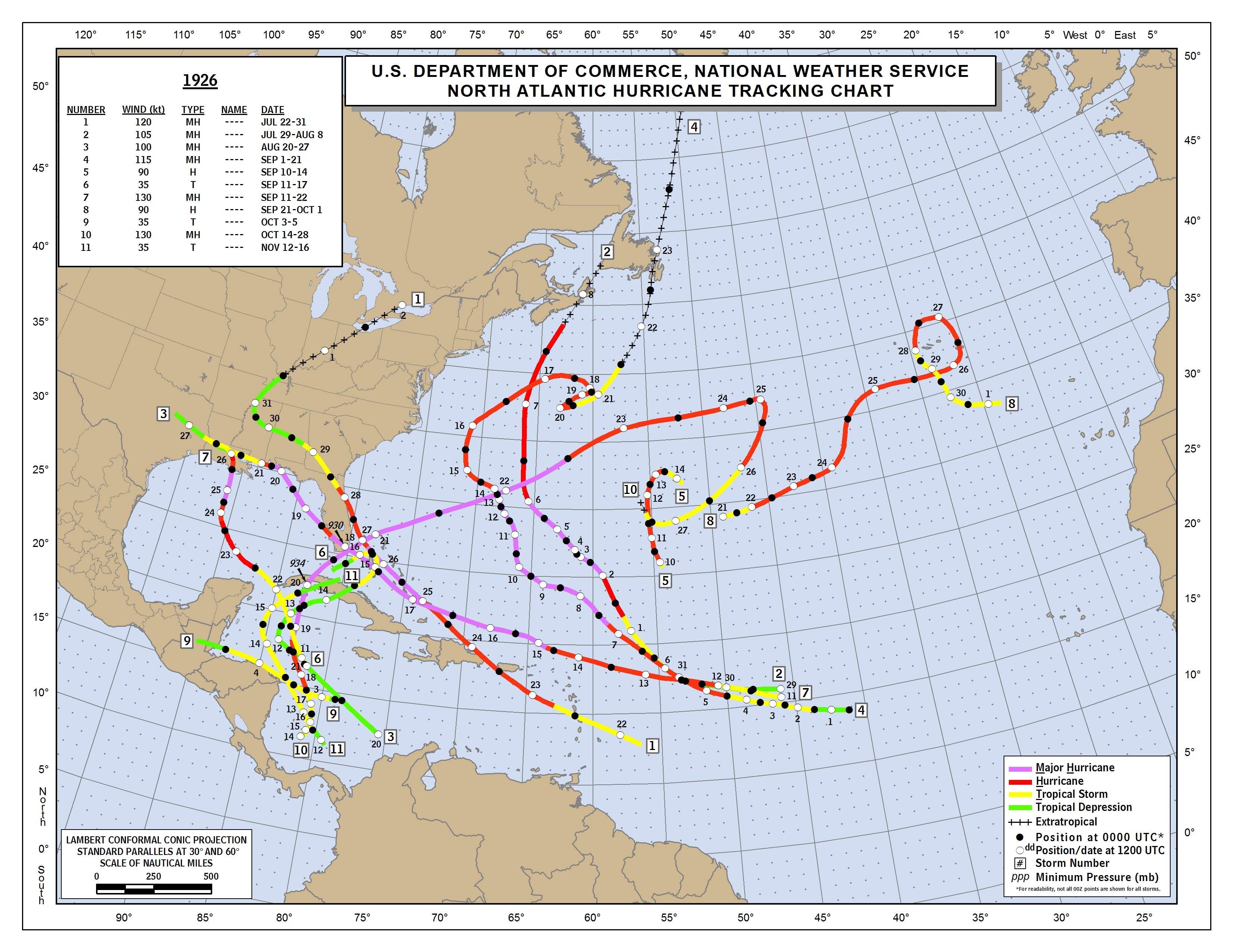
~ 1926 Fire Tiger:
July – Nassau hurricane of 1926, hits as a Category 4 hurricane in the Bahamas unusually early in the season for such severity, during July 25. The hurricane went on to make a Florida landfall the day after near Smyrna beach as a Cat 2.
Aug – A small Category 3 hurricane struck west of Houma, Louisiana on August 25, after traversing the central Gulf of Mexico on a northward track after having entered the GOM from the NW caribbean. Despiite the storm’s small size, a 15 foot storm surge was reported and crops were damaged.
Sep – The Great Miami Hurricane of 1926, a Category 4 monster, passed north of the Lesser Antilles before crashing into the Bahamas and South Florida during Sept 17-18 with 150 mph winds. Miami was devastated by this beast, and to this day is regarded as one of the most infamous hurricanes of all time, as well as the worst direct hit on downtown Miami itself since records have been kept. After this strike, the hurricane went on to strike Alabama as a Cat 3, dealing a devastating blow to the coast there as well as the western panhandle of Florida. Hundreds were killed by this hurricane.
Oct – Havana – Bermuda Hurricane, Oct 20 – 25, great hurricane at Cuba where it struck as a Category 4, before heading into the Bahamas as well as a major hurricane. Over 700 people were killed, with 600 in Cuba alone.
~ 1938 Earth Tiger:
Aug – Category 3 hurricane makes landfall on the northern Yucatan peninsula late on Aug 25, causing significant impacts in and around Cozumel. The hurricane entered the Bay of Campeche afterward as a Cat 1 storm and eventually made a second landfall in Mexico as Cat 1 bringing significant flooding.
Sep – The Long Island Express hurricane strikes New England as a cat 3, causing massive devastation and claiming 682 lives. The hurricane reached category 5 in the days prior to its New England strike, and even though it came down to a Cat 3, the hurricane still produced extremely powerful winds and a storm surge of 18-25 feet.
~ 1950 Metal Tiger:
Sep – Hurricane Easy looped around the west coast of Florida while making 2 landfalls, one of them in Cedar Key as a Cat 3 hurricane with 120 mph winds, and the other landfall just north of Tampa. The hurricane brought a record 38 inches of rain in 24 hours, making it Florida’s wettest hurricane on record.
Oct – Hurricane King makes a direct Cat 4 landfall over the Miami-Ft. Lauderdale area from the south-southeast during Oct 17-18 with 130 mph winds, after hitting Cuba a day earlier as a 90 mph storm. The hurricane was small in size, but very powerful and it delivered the worst impact to the Miami area since the 1926 hurricane.
~ 1974 Wood Tiger:
Sep – Sep 1-10: Hurricane Carmen struck the Yucatan as a powerful 150 mph Cat 4, north of Chetumal in early September before heading northward into the GOM and striking Louisiana as a Cat 3 during Sept 9-10, causing significant impacts. Sep 14-22: Hurricane Fifi cruised the Caribbean strengthening to a 110 mph Cat 2 as it moved into northern Honduras and Belize, weakened inland, yet producing extremely catastrophic flooding that led to the deadliest Atlantic hurricane since 1900. This storm was likely the deadliest non-major hurricane in the Atlantic in recorded history, which killed 8,000+ in a disaster eerily similar to what would occur 24 years later in 1998.
~ 1998 Earth Tiger:
Aug – Hurricane Bonnie avoids the Bahamas as a Cat 3 but curves into the Carolinas, making a damaging Cat 2 landfall in Wilmington on Aug 27 with 110 mph winds, before weakening and turning east and exiting out into the Atlantic. 5 deaths were caused by this storm.
Sep – Hurricane Georges strikes the Leewards and Puerto Rico as a 115 mph Cat 3 hurricane on Sept 21, after weakening from its 155 mph peak the day before. The hurricane went on to strike the Dominican republic as a 120 mph Cat 3 on Sept 22, before weakening and affecting the rest of Hispaniola and Cuba as a low-end hurricane until reaching the Florida Keys. By the time Georges reached the keys, it struck Key West as a 105 mph Cat 2 on Sept 25. 3 days later, as a Cat 2 again, the storm struck Biloxi MS. Georges proved to be a very damaging and impactful hurricane which also left over 380 people dead.
Oct-Nov – Hurricane Mitch becomes a Cat 5 monster in the NW Caribbean during Oct 25-27 before slowly sinking southward into Central America, making Landfall in northern Honduras late October and persisting inland with torrential rains lasting into the first days of November, unleashing a catastrophe similar to 1974’s Fifi but even deadlier, making Mitch the 2nd deadliest hurricane in Atlantic history, second only to the 1780 hurricane. Over 11,000 people lost their lives to this monster hurricane.
~ 2010 Metal Tiger:
June – Hurricane Alex makes a significant Cat 2 landfall in northern Mexico on June 30, with 110 mph winds. Alex’s torrential rains triggered severe flooding, and the storm is blamed for 51 deaths in Mexico.
Sep – There were several notable hurricanes that were borderline events in including them as significant landfalls or impactful storms. Of these storms there was Hurricane Earl which brushed the northern Leewards and Puerto Rico/Hispaniola late August – Early September as it stayed offshore as a Cat 4. Then there was an incredibly large and powerful hurricane by the name of Igor that missed land up until making landfall in Nova Scotia as an impactful Cat 1 storm on Sept 21. Then during Sep 17-18, Hurricane Karl did however manage to make a major Cat 3 landfall, striking Mexico in the Bay of Campeche with 115 mph winds after briefly attaining major status before a quick demise once inland. Karl would be the significant landfall of September as well as the strongest landfall of 2010. 22 people were killed in Mexico by Karl.
Oct – Hurricane Richard makes a 100 mph Cat 2 landfall on the Yucatan on October 25, causing moderate to significant impacts. This was a borderline event but enough to be considered a significant landfall.
Nov – Hurricane Tomas, one of the most impactful hurricanes of 2010, came at the tail end of the season and was the last storm of 2010. The storm hit St. Lucia as a 100 mph Cat 2 on Oct 30, while causing impacts to other nearby islands in the Leewards. 14 people died in the Leewards due to Tomas. The storm then went on to affect Haiti in Early November as a Cat 1, causing severe flooding that led to 35 additional deaths.
The Tiger Years and Atlantic Hurricane Landfalls:

Notice how certain areas like Cuba, the Bahamas and Peninsular Florida are more common targets during these years, especially the active-era Tiger Years. The Year of the Tiger seems to favor threatening storms heading more west, while maintaining over the Antilles or just north of the Antilles on a path towards the Southeast US, particularly Florida, during this 12-year cycle compared to some others. Only the Years of Rat, Monkey, Rooster and Dragon have delivered this much action to this part of the world, so the Tiger is a big one to watch for if you’re in the Cuba/FL/Bahamas region, they really can be landfall-heavy years and bad ones for these areas. Other clusters are apparent along the northern/western Gulf Coast at Texas and Louisiana, along the Eastern Greater Antilles and Lesser Antilles, as well as down in the Western Caribbean along the Yucatan and Central America. Tiger years have brought the two deadliest hurricanes on record for Central America, in 1974 & 1998, so that’s a big thing to keep in mind too. Overall this wizardry says 2022 may be far more severe than 2021 was with impacts, and the areas that escaped getting battered in 2020/2021 may get whacked in 2022.
Significant Landfalling Hurricanes per Tiger Year since 1851:
1854/2, 1866/2, 1878/2, 1890/0, 1902/0, 1914/0, 1926/4, 1938/2, 1950/2, 1962/0, 1974/2, 1986/0, 1998/3, 2010/4.
Average # of significant landfalling hurricanes per Tiger Year = 23/14 yrs = 1.64.
This is a very strong average, especially considering there were some very slow years in this mix. The active Tiger years were extreme enough that the average still comes up as 2 significant landfalls for a Tiger Year when rounding up. This really shows that if we have a Tiger year during an active multi-decadal era, it will be very likely that we will have 2+ significant landfalls, and more likely 3 to 4 of them! Since we are likely still within an active era, and the fact that 2022 is the Water Tiger year, we could see some sort of balance between the insane amount of significant landfalls active-era tiger years can bring and the overall slower nature of the Water Tiger year, so there may actually be 2 to 3 strong landfalls this season (rather than 4 like 1926 or 2010). Also, one or two of the 2-3 potential strong hurricane landfalls this season could very well be a Category 3-4 too, and be one that brings high impacts, possibly even infamous-tier, like 1926 Miami, 1938 Long Island or 1998 Mitch.
I think all that you’ve read up to this point, adds some credence to a potentially tricky and dangerous, above-average 2022 season, which could get us as far as to the ‘V’ name, with a handful of hurricanes. This is how I think 2022 could end up being, and considering my parameters 1 and 2, here goes my formal yet crazy experimental prediction:
2022 Atlantic Hurricane Season Prediction:
2022 ends up with 20 named storms, 9 of which become hurricanes, and 4 major hurricanes. There are 4 possible scenarios based on the history of Tiger Years that could end up being the main highlights of the season impact-wise. To be clear, we should not expect all four scenarios to play out this year, but perhaps 1 to 2 of them could. The 4 Possible Scenarios for 2022 are as follows:
1.) Approx. between August 25 – October 5… There will likely be a Category 3 or 4 Cape Verde hurricane that passes just north of the lesser Antilles and Puerto Rico – Hispaniola, brushing these islands (although a direct strike like Georges 1998 cannot be ruled out). This monster hurricane will then likely continue west-northwest into the Bahamas and possibly South Florida, including the keys. Here the potential storm may take one of 3 possible paths after the Bahamas, either 1. straight into South FL like in 1926 and then NW into the northern GOM in the general direction of Louisiana/MS, or 2. through the FL Straits as a Major like 1842, blasting the Keys and northern Cuba, and afterwards heading for TX/Northern Mexico. A 3rd possible path is a hard right over the Bahamas and then up north towards the Carolinas/Virginia. Analog hurricanes for this scenario are the Antje Hurricane 1842, 1866 Bahamas hurricane, 1926 Miami Hurricane, and Hurricane Georges 1998. Mid-Late September could be the likeliest timeframe for this event. It is possible that this storm could attain Category 5 during some part of its life cycle too.
2.) Approx. September 15 – 30… A strong hurricane, possibly Cat 2-3, could form in the Caribbean near Jamaica, possibly impacting the island, before heading NW through Cuba and then into the Northeast GOM. Once in the GOM, this storm may hook right into the Cedar Key area of Florida, similar to the 1842 Cedar Key hurricane or Hurricane Easy 1950. Tampa could get a close shave from this one. Once the storm exits FL northeastward, it could affect the Carolinas and Outer Banks as a weakening storm.
3.) Approx. between September 20 – October 30… We could also see a significant landfall in Central America, a la Mitch 1998 or Fifi 1974, most likely affecting Belize, Guatemala and Honduras with flooding rains and destructive winds. There’s a chance that this same storm could cross the Yucatan into the Bay of Campeche to make another landfall in Mexico, if the storm doesn’t get buried into Central America. Mid-Late October would seem like the likeliest time for this storm. This scenario’s hurricane also has a possibility of reaching Category 5 at some point of its life cycle.
4.) Approx. October 10 – 25… A strong storm, likely Cat 2 or Cat 3, could form in the Caribbean and head northward into Western Cuba, then pass near or over the FL Keys and potentially affect SE Florida. The storm analogs that come to mind are the October 1926 Cuba-Bahamas Hurricane, and Hurricane King 1950.
~ The following map outlook shows which areas may get hurricane threats or hits in 2022 based on all this stuff:
2022 Hurricane Watch Areas, Based on the History of Tiger-Year Cycle:

2022 will likely end up being borderline hyperactive, if not low-end hyperactive with 2 to 3 major landfalls that could bring much impacts. The Tiger-year cycle also tells us that 2022 could be fairly back-loaded, with its most significant events happening during September-October. We may get a quick start during June/July, then a lull that lasts until Aug 20 before the lid comes off as August yields to September. Being a Water Tiger year, I'd side with Scenario 1’s Bahamas - FL straits/Keys Hurricane that then heads into the GOM, and Scenario 2’s Caribbean/Cuba system that goes to the Cedar Key, FL area, as being the likeliest specific outcomes. The cities of Miami/Ft. Lauderdale, Tampa and New Orleans are also uncomfortably close to these possible tracks, so these metro areas could be among the most affected in 2022. Other areas, such as the Carolinas and Central Texas, may be impacted by other weaker systems, or the same big storms that may affect Cuba/FL/Bahamas once they have weakened some. This season has a higher potential than normal to be a high impact season based on the Chinese Zodiac cycle alone, so heads up just in case my crazy crystal ball ends up being close to reality!
Alright guys, all that which you've read is just my 2 cents, so please take all of the above with a grain of salt. I must say, however, all of this does give some reason to think that we might be in for a rough ride this year in the tropics on this side of the world. Hopefully we can get some luck this season, and see the strongest storms recurve OTS, but this again would take lots of luck IMO considering the 12 year cycle we’re in. As I’ve mentioned before, This thread is experimental and probably geared more towards amusement rather than serious predictions, so take this as my disclaimer. The future conditions of the Atlantic, i.e. the SST's, ENSO, Teleconnections, MDR favorability, SAL and other meteorological indicators/factors will have the ultimate say in how the season goes, and these factors could change as we head into the peak of hurricane season.
Let’s see how 2022 evolves over the next several months, it should be fun and exciting to watch and see if this esoteric stuff has any real meaning to the hurricane season once again.
Feel free to ask me questions or write whatever you wish here! We can track 2022 here too, and I’ll
try to keep this thread alive by posting updates, other experimental takes, visuals, and such whenever possible!
-FR
3/11/2022


