Works for me. Normals are now cool enough that temps running a tad above normal are delightful.. What a nice stretch we are having. After months of meltdown heat and humidity we can now brag about the FL weather again.
Florida Weather
Moderator: S2k Moderators
Forum rules

The posts in this forum are NOT official forecast and should not be used as such. They are just the opinion of the poster and may or may not be backed by sound meteorological data. They are NOT endorsed by any professional institution or STORM2K.
Re: Florida Weather
Works for me. Normals are now cool enough that temps running a tad above normal are delightful.. What a nice stretch we are having. After months of meltdown heat and humidity we can now brag about the FL weather again.
0 likes

Re: Florida Weather
GFS and Euro are on a fairly good agreement that next Tuesday and Wednesday will be very chilly across the FL Peninsula. Highs only in the 60s across central FL on Tuesday with lows in the 30s north of I-4, 40s south of it into parts of south FL Wednesday morning.
0 likes
-
HURRICANELONNY
- Category 5

- Posts: 1392
- Joined: Wed May 07, 2003 6:48 am
- Location: HOLLYWOOD.FL
Re: Florida Weather
Ahh. Should be a nice dry and cool Thanksgiving. I think I read also a partial lunar eclipse for Thanksgiving. Gonna love it. 
0 likes
hurricanelonny
-
HURRICANELONNY
- Category 5
- Posts: 1392
- Joined: Wed May 07, 2003 6:48 am
- Location: HOLLYWOOD.FL
Re: Florida Weather
Oops. Lunar eclipse is tonight but for sure won't be able to see it. Had wrong Thursday 
0 likes
hurricanelonny
-
SFLcane

- S2K Supporter

- Posts: 10281
- Age: 48
- Joined: Sat Jun 05, 2010 1:44 pm
- Location: Lake Worth Florida
Re: Florida Weather
NDG wrote:GFS and Euro are on a fairly good agreement that next Tuesday and Wednesday will be very chilly across the FL Peninsula. Highs only in the 60s across central FL on Tuesday with lows in the 30s north of I-4, 40s south of it into parts of south FL Wednesday morning.
Um….nope. How about low-mid 60’s for night time lows across SFL.
Models always trend warmer never fails
0 likes
-
gatorcane

- S2K Supporter
- Posts: 23708
- Age: 48
- Joined: Sun Mar 13, 2005 3:54 pm
- Location: Boca Raton, FL
Re: Florida Weather
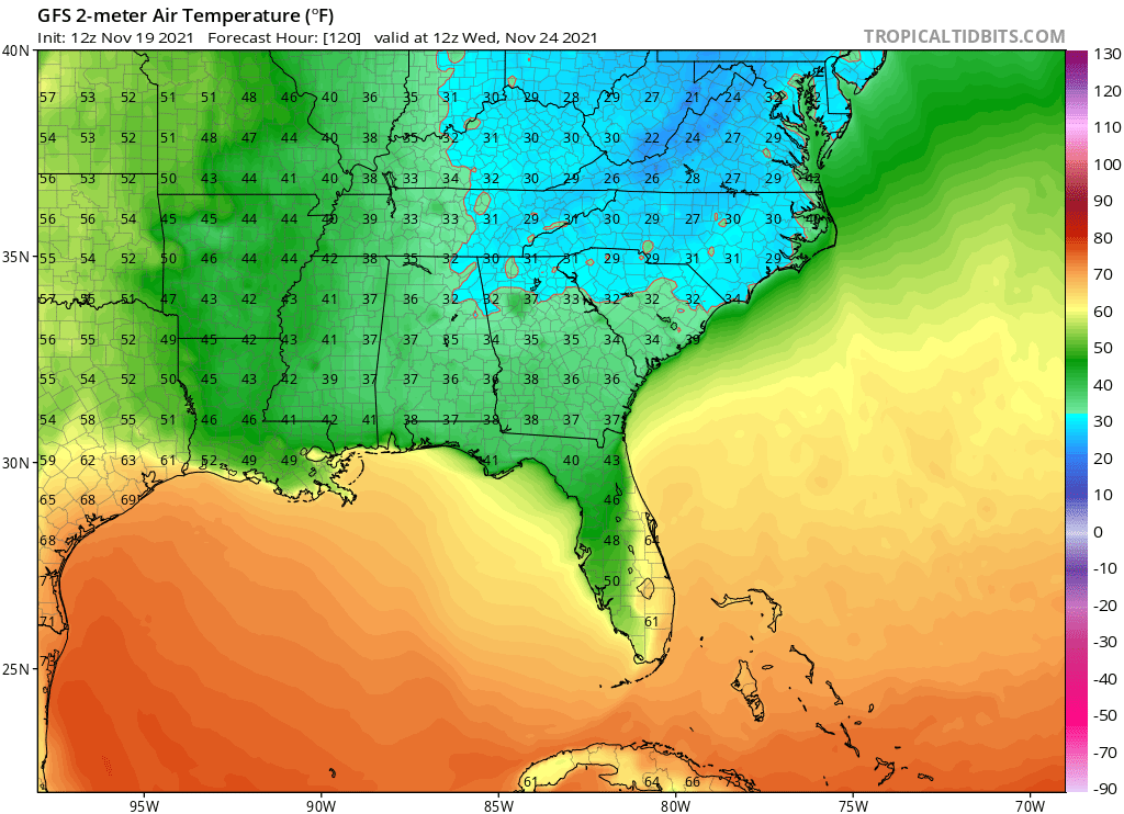
Check out this temp gradient across peninsula Florida due to winds out of the ENE:
0 likes
Re: Florida Weather
SFLcane wrote:NDG wrote:GFS and Euro are on a fairly good agreement that next Tuesday and Wednesday will be very chilly across the FL Peninsula. Highs only in the 60s across central FL on Tuesday with lows in the 30s north of I-4, 40s south of it into parts of south FL Wednesday morning.
Um….nope. How about low-mid 60’s for night time lows across SFL.
Models always trend warmer never fails
Sorry I jinxed it, lmao.
Talked about the GFS and Euro backing away, wow!
I should had known better, I’m usually preaching the don’t believe the models’ forecast lows for FL past 4-5 days.
0 likes
Re: Florida Weather
Looks like Orlando will end November near average, "coolest" November since 2014.
0 likes

Re: Florida Weather
True NDG, this second half of November for Central Florida has been the coolest string of days/nights that I can recall recently. Recovery from an unexpected bypass surgery 3 weeks ago has me needing to do a fair amount of daily walking and the daily mid 60's to low 70's have been great!
Mid to long term EURO & GFS are beginning to look a bit more like they just remembered that LaNina is in place though LOL. Sure would be nice if December remained "coolish" overall as well but i'm not overly confident. Starting the end of this upcoming week, it definitely looks like an increasing temperature gradient for South & Central Florida, verses the Northern Florida region.
Mid to long term EURO & GFS are beginning to look a bit more like they just remembered that LaNina is in place though LOL. Sure would be nice if December remained "coolish" overall as well but i'm not overly confident. Starting the end of this upcoming week, it definitely looks like an increasing temperature gradient for South & Central Florida, verses the Northern Florida region.
0 likes
Andy D
(For official information, please refer to the NHC and NWS products.)
(For official information, please refer to the NHC and NWS products.)
Re: Florida Weather
chaser1 wrote:True NDG, this second half of November for Central Florida has been the coolest string of days/nights that I can recall recently. Recovery from an unexpected bypass surgery 3 weeks ago has me needing to do a fair amount of daily walking and the daily mid 60's to low 70's have been great!
Mid to long term EURO & GFS are beginning to look a bit more like they just remembered that LaNina is in place though LOL. Sure would be nice if December remained "coolish" overall as well but i'm not overly confident. Starting the end of this upcoming week, it definitely looks like an increasing temperature gradient for South & Central Florida, verses the Northern Florida region.
Wow, sorry about to hear about your unexpected surgery. Sounds like you are on a speedy recovery, good to hear.
Yes, it has been great, it has definitely given a nice break at times to my A/C.
0 likes
Re: Florida Weather
Thanks NDG, I appreciate that . Every day getting better and better. As for cool weather for the month to come, I sure hope it at least stays mild to cool. After this past hurricane season and even now into this moderate La Nina, I'm conceding while waiving my white flag with regard to trying to anticipate or figure out the weird global patterns LOL. Furthermore, I am tending to have less and less confidence in anything that GFS or EURO put out there.
0 likes
Andy D
(For official information, please refer to the NHC and NWS products.)
(For official information, please refer to the NHC and NWS products.)
Re: Florida Weather
Get ready to torch for a while. NAO- obliterated, and the Atlantic ridge flexing. La Nina winter is going to be a thing.
0 likes
Re: Florida Weather
Nice stretch of carefree weather underway as we tilt above normal for a long stretch. Above normal temps as we march through solar winter is a good combo.
0 likes
Re: Florida Weather
Doesn't look like much weather of significance for Florida through Christmas. If anything, looks a little rainier than would be typical for December.
Cool November almost always gives way to a warm December, at least for us.
Cool November almost always gives way to a warm December, at least for us.
0 likes
-
floridasun
- Tropical Storm

- Posts: 245
- Joined: Tue Sep 14, 2021 3:59 pm
Re: Florida Weather
look like it be very warm in deep south ((i mean south fl ))after we got cold weather right after thanksgiving
0 likes

Re: Florida Weather
0 likes
-
HURRICANELONNY
- Category 5
- Posts: 1392
- Joined: Wed May 07, 2003 6:48 am
- Location: HOLLYWOOD.FL
Re: Florida Weather
As per the Miami NWS discussion 12/18: Thursday and Friday mornings could be some of the
chilliest of the season so far with most areas falling into the 50s
and even some mid to upper 40s. Again, things are still early and
could change but the forecast continues to trend cooler behind the
front.

chilliest of the season so far with most areas falling into the 50s
and even some mid to upper 40s. Again, things are still early and
could change but the forecast continues to trend cooler behind the
front.
0 likes
hurricanelonny
Re: Florida Weather
Hurricane force wind gusts reported in the Punta Gorda area this morning, pure pressure gradient winds.
https://twitter.com/WrightDobbs/status/1473303634196799500
https://twitter.com/WrightDobbs/status/1473303634196799500
0 likes
Re: Florida Weather
NAO is going positive just in time to spare FL from the core of the Arctic invasions into the US.

0 likes
Return to “USA & Caribbean Weather”
Who is online
Users browsing this forum: No registered users and 19 guests