I could easily try to get Category 4 tonight or tomorrow.
EPAC: RICK - Remnants
Moderator: S2k Moderators
-
Hurricane2021
- Tropical Storm

- Posts: 108
- Age: 33
- Joined: Mon Jul 05, 2021 2:54 pm
- Contact:
Re: EPAC: RICK - Hurricane
Hurricane Rick is basically doing what Hurricane Pamela was supposed to do  . I wouldn't be surprised if Recon finds a Category 2 Hurricane...
I could easily try to get Category 4 tonight or tomorrow.
I could easily try to get Category 4 tonight or tomorrow.
0 likes

Re: EPAC: RICK - Hurricane
0 likes
Kendall -> SLO -> PBC
Memorable Storms: Katrina (for its Florida landfall...) Wilma Matthew Irma
Memorable Storms: Katrina (for its Florida landfall...) Wilma Matthew Irma
-
cycloneye

- Admin

- Posts: 149547
- Age: 69
- Joined: Thu Oct 10, 2002 10:54 am
- Location: San Juan, Puerto Rico
Re: EPAC: RICK - Hurricane
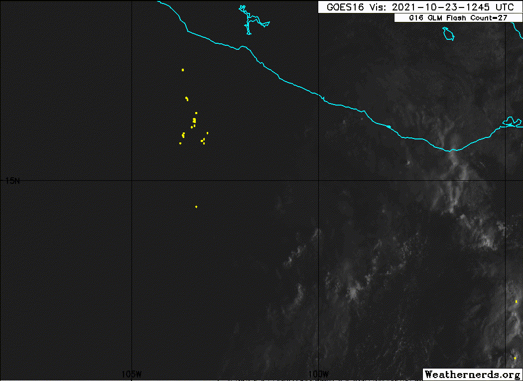
BULLETIN
Hurricane Rick Advisory Number 5
NWS National Hurricane Center Miami FL EP172021
1000 AM CDT Sat Oct 23 2021
...HURRICANE WARNING ISSUED FOR A PORTION OF THE SOUTHWEST COAST OF
MEXICO...
SUMMARY OF 1000 AM CDT...1500 UTC...INFORMATION
-----------------------------------------------
LOCATION...14.7N 101.5W
ABOUT 205 MI...335 KM S OF ZIHUATANEJO MEXICO
ABOUT 185 MI...300 KM SW OF ACAPULCO MEXICO
MAXIMUM SUSTAINED WINDS...80 MPH...130 KM/H
PRESENT MOVEMENT...NNW OR 345 DEGREES AT 7 MPH...11 KM/H
MINIMUM CENTRAL PRESSURE...985 MB...29.09 INCHES
WATCHES AND WARNINGS
--------------------
CHANGES WITH THIS ADVISORY:
The government of Mexico has changed the Hurricane Watch to a
Hurricane Warning from Tecpan de Galeana to Punta San Telmo. The
government of Mexico has changed the Tropical Storm Watch to a
Tropical Storm Warning east of Tecpan de Galeana to Acapulco, and
west of Punta San Telmo to Manzanillo.
SUMMARY OF WATCHES AND WARNINGS IN EFFECT:
A Hurricane Warning is in effect for...
* Tecpan de Galeana to Punta San Telmo
A Tropical Storm Warning is in effect for...
* East of Tecpan de Galeana to Acapulco
* West of Punta San Telmo to Manzanillo
A Hurricane Warning means that hurricane conditions are expected
somewhere within the warning area. A warning is typically issued
36 hours before the anticipated first occurrence of
tropical-storm-force winds, conditions that make outside
preparations difficult or dangerous. Preparations to protect life
and property should be rushed to completion.
A Tropical Storm Warning means that tropical storm conditions are
expected somewhere within the warning area within 36 hours.
For storm information specific to your area, please monitor
products issued by your national meteorological service.
DISCUSSION AND OUTLOOK
----------------------
At 1000 AM CDT (1500 UTC), the center of Hurricane Rick was located
near latitude 14.7 North, longitude 101.5 West. Rick is moving
toward the north-northwest near 7 mph (11 km/h). A
north-northwestward to northward motion is expected over the next
couple of days. On the forecast track, the center of Rick will
approach the coast of Mexico on Sunday and Sunday night.
Maximum sustained winds have increased to near 80 mph (130 km/h)
with higher gusts. Rapid strengthening is forecast during the next
day or so, and Rick is expected to become a major hurricane on
Sunday.
Hurricane-force winds extend outward up to 15 miles (30 km) from the
center and tropical-storm-force winds extend outward up to 70 miles
(110 km).
The estimated minimum central pressure is 985 mb (29.09 inches).
HAZARDS AFFECTING LAND
----------------------
WIND: Hurricane conditions are expected within the Hurricane
Warning area by late Sunday, with tropical storm conditions
expected by Sunday afternoon. Tropical storm conditions are
expected within the Tropical Storm Warning areas by Sunday
afternoon.
STORM SURGE: A storm surge is expected to produce significant
coastal flooding in areas of onshore winds near and to the east of
where the center of Rick makes landfall in southwestern Mexico.
Near the coast, the surge will be accompanied by large and
destructive waves.
RAINFALL: Rick is expected to produce 5 to 10 inches of rain with
isolated storm total amounts of 20 inches across coastal sections of
the Mexican states of Guerrero and Michoacan from tonight through
Tuesday. This heavy rainfall will likely produce flash flooding
and mudslides.
SURF: Swells generated by Rick will begin to affect portions of the
southwestern coast of Mexico later today. These swells are likely
to cause life-threatening surf and rip current conditions. Please
consult products from your local weather office.
NEXT ADVISORY
-------------
Next intermediate advisory at 100 PM CDT.
Next complete advisory at 400 PM CDT.
$$
Forecaster Pasch
Hurricane Rick Discussion Number 5
NWS National Hurricane Center Miami FL EP172021
1000 AM CDT Sat Oct 23 2021
Rick continues to quickly become better organized on satellite
images, with a growing Central Dense Overcast surrounded by a
well-defined convective band wrapping almost completely around the
circulation. The latest Dvorak intensity estimates from TAFB and
SAB were 65 kt at around 1200 UTC and with the steady strengthening
trend underway, the advisory intensity is set at 70 kt.
Upper-outflow is prominent over all quadrants of the cyclone. An
Air Force Reserve Unit Hurricane Hunter aircraft is scheduled to
investigate Rick later today to provide additional intensity and
structure information.
Latest high-resolution visible satellite images indicate that the
hurricane is moving a little faster toward the north-northwest, or
at about 345/6 kt. Rick is expected to move between
north-northwest and north, through a weakness in the
mid-tropospheric subtropical ridge, during the next couple of days.
There continues to be significant spread in the track guidance
models with the GFS being the easternmost and fastest, taking
Rick on a mainly northward track. The ECMWF is slower and farther
west, and some other models are even slower and farther west over
southwestern Mexico or just off the coast. The official track
forecast is, again, shifted somewhat to the east of the previous
one and generally follows the HCCA consensus prediction.
As noted earlier, the atmospheric and oceanic environment for Rick
appears to be very conducive for intensification during the next
24-36 hours, with low shear, high mid-level moisture, and high
oceanic heat content. The SHIPS Rapid Intensification Index
continues to show a high probability of Rapid Intensification into
Sunday, and this is reflected in the official intensity forecast,
which is near the upper end of the guidance. In 36 to 48 hours,
increasing shear and drier air could cause the strengthening trend
to end or even result in some weakening.
Based on the latest forecast, the government of Mexico has issued
Hurricane and Tropical Storm Warnings for portions of the southwest
coast of Mexico.
Key Messages:
1. Rick is forecast to be at or near major hurricane strength when
it reaches the coast of southern Mexico by Sunday night or Monday,
and life-threatening storm surge and dangerous hurricane-force
winds are expected within the Hurricane Warning area from Tecpan de
Galeana to Punta San Telmo. There is larger-than-normal
uncertainty in the track forecast of Rick, and the arrival time of
hazardous conditions within the watch area could change
significantly with future forecasts. Residents in this area should
follow any advice given by local officials and check updates
to the forecast.
2. Rick is expected to bring tropical storm conditions to
portions of the southern and southwestern coasts of Mexico as early
as Sunday from east of Tecpan de Galeana to Acapulco, and by Monday
morning from west of Punta San Telmo to Manzanillo, where a Tropical
Storm Warning is in effect.
3. Heavy rains associated with Rick are expected to move into the
Mexican states of Guerrero and Michoacan starting later today, and
could persist through Monday night. This rainfall will likely
produce flash flooding and mudslides.
FORECAST POSITIONS AND MAX WINDS
INIT 23/1500Z 14.7N 101.5W 70 KT 80 MPH
12H 24/0000Z 15.4N 101.8W 85 KT 100 MPH
24H 24/1200Z 16.0N 102.0W 100 KT 115 MPH
36H 25/0000Z 16.8N 102.2W 105 KT 120 MPH
48H 25/1200Z 18.0N 102.5W 90 KT 105 MPH...ON THE COAST
60H 26/0000Z 19.6N 103.0W 50 KT 60 MPH...INLAND
72H 26/1200Z 20.5N 103.5W 25 KT 30 MPH...INLAND
96H 27/1200Z...POST-TROP/INLAND
$$
Forecaster Pasch
0 likes
Visit the Caribbean-Central America Weather Thread where you can find at first post web cams,radars
and observations from Caribbean basin members Click Here
and observations from Caribbean basin members Click Here

Re: EPAC: RICK - Hurricane
I think the precursor to Rick was a wave that some GFS runs had quickly spinning up near Central America, and we’ve all been expecting something in the WCar being a La Niña October, so clearly we have been rickrolled by Rick.
5 likes
Irene '11 Sandy '12 Hermine '16 5/15/2018 Derecho Fay '20 Isaias '20 Elsa '21 Henri '21 Ida '21
I am only a meteorology enthusiast who knows a decent amount about tropical cyclones. Look to the professional mets, the NHC, or your local weather office for the best information.
I am only a meteorology enthusiast who knows a decent amount about tropical cyclones. Look to the professional mets, the NHC, or your local weather office for the best information.
-
Astromanía
- Category 2

- Posts: 796
- Age: 27
- Joined: Sat Aug 25, 2018 10:34 pm
- Location: Monterrey, N.L, México
-
InfernoFlameCat

- Category 5

- Posts: 2127
- Age: 22
- Joined: Mon Dec 14, 2020 10:52 am
- Location: Buford, GA
Re: EPAC: RICK - Hurricane
Rick surprised me this morning .
1 likes
I am by no means a professional. DO NOT look at my forecasts for official information or make decisions based on what I post.
Goal: to become a registered expert over tropical and subtropical cyclones.
Goal: to become a registered expert over tropical and subtropical cyclones.
-
cycloneye
- Admin
- Posts: 149547
- Age: 69
- Joined: Thu Oct 10, 2002 10:54 am
- Location: San Juan, Puerto Rico
EPAC: PAMELA - Remnants
Astromanía wrote:Even though it didn't was the hurricane we were expecting, this is for now the deadliest hurricane this season killing 10 people, but that is most probably going to change when Rick makes landfall sadly.
Are there big cities at landfall area?
0 likes
Visit the Caribbean-Central America Weather Thread where you can find at first post web cams,radars
and observations from Caribbean basin members Click Here
and observations from Caribbean basin members Click Here
-
Sciencerocks
- Category 5
- Posts: 10186
- Age: 40
- Joined: Thu Jul 06, 2017 1:51 am

Re: EPAC: RICK - Hurricane
aspen wrote:I think the precursor to Rick was a wave that some GFS runs had quickly spinning up near Central America, and we’ve all been expecting something in the WCar being a La Niña October, so clearly we have been rickrolled by Rick.
To be fair, I think there's a good chance something similar happens in the Atlantic later this season when conditions become more favorable.
0 likes
TC naming lists: retirements and intensity
Most aggressive Advisory #1's in North Atlantic (cr. kevin for starting the list)
Most aggressive Advisory #1's in North Atlantic (cr. kevin for starting the list)
-
Yellow Evan

- Professional-Met

- Posts: 16242
- Age: 27
- Joined: Fri Jul 15, 2011 12:48 pm
- Location: Henderson, Nevada/Honolulu, HI
- Contact:
Re: EPAC: RICK - Hurricane
Was trying to clear a pinhole eye but seems that dry air got in the way.
1 likes
-
Yellow Evan
- Professional-Met
- Posts: 16242
- Age: 27
- Joined: Fri Jul 15, 2011 12:48 pm
- Location: Henderson, Nevada/Honolulu, HI
- Contact:
-
Yellow Evan
- Professional-Met
- Posts: 16242
- Age: 27
- Joined: Fri Jul 15, 2011 12:48 pm
- Location: Henderson, Nevada/Honolulu, HI
- Contact:
-
cycloneye
- Admin
- Posts: 149547
- Age: 69
- Joined: Thu Oct 10, 2002 10:54 am
- Location: San Juan, Puerto Rico
Re: EPAC: RICK - Hurricane
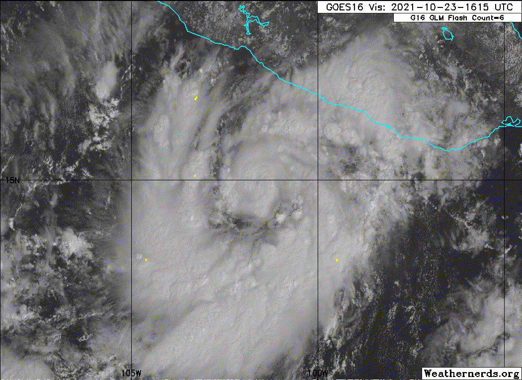
BULLETIN
Hurricane Rick Intermediate Advisory Number 5A
NWS National Hurricane Center Miami FL EP172021
100 PM CDT Sat Oct 23 2021
...HURRICANE HUNTERS CURRENTLY INVESTIGATING RICK...
SUMMARY OF 100 PM CDT...1800 UTC...INFORMATION
----------------------------------------------
LOCATION...14.9N 101.8W
ABOUT 195 MI...315 KM S OF ZIHUATANEJO MEXICO
ABOUT 185 MI...295 KM SW OF ACAPULCO MEXICO
MAXIMUM SUSTAINED WINDS...85 MPH...135 KM/H
PRESENT MOVEMENT...NNW OR 340 DEGREES AT 7 MPH...11 KM/H
MINIMUM CENTRAL PRESSURE...980 MB...28.94 INCHES
WATCHES AND WARNINGS
--------------------
CHANGES WITH THIS ADVISORY:
None.
SUMMARY OF WATCHES AND WARNINGS IN EFFECT:
A Hurricane Warning is in effect for...
* Tecpan de Galeana to Punta San Telmo
A Tropical Storm Warning is in effect for...
* East of Tecpan de Galeana to Acapulco
* West of Punta San Telmo to Manzanillo
A Hurricane Warning means that hurricane conditions are expected
somewhere within the warning area. A warning is typically issued
36 hours before the anticipated first occurrence of
tropical-storm-force winds, conditions that make outside
preparations difficult or dangerous. Preparations to protect life
and property should be rushed to completion.
A Tropical Storm Warning means that tropical storm conditions are
expected somewhere within the warning area within 36 hours.
For storm information specific to your area, please monitor
products issued by your national meteorological service.
DISCUSSION AND OUTLOOK
----------------------
At 100 PM CDT (1800 UTC), the center of Hurricane Rick was located
near latitude 14.9 North, longitude 101.8 West. Rick is moving
toward the north-northwest near 7 mph (11 km/h). A
north-northwestward to northward motion is expected over the next
couple of days. On the forecast track, the center of Rick will
approach the coast of Mexico on Sunday and Sunday night.
Maximum sustained winds have increased to near 85 mph (135 km/h)
with higher gusts. Rapid strengthening is forecast during the next
day or so, and Rick is expected to become a major hurricane on
Sunday.
Hurricane-force winds extend outward up to 15 miles (30 km) from
the center and tropical-storm-force winds extend outward up to 70
miles (110 km).
The estimated minimum central pressure is 980 mb (28.94 inches).
HAZARDS AFFECTING LAND
----------------------
WIND: Hurricane conditions are expected within the Hurricane
Warning area by late Sunday, with tropical storm conditions
expected by Sunday afternoon. Tropical storm conditions are
expected within the Tropical Storm Warning areas by Sunday
afternoon.
STORM SURGE: A storm surge is expected to produce significant
coastal flooding in areas of onshore winds near and to the east of
where the center of Rick makes landfall in southwestern Mexico.
Near the coast, the surge will be accompanied by large and
destructive waves.
RAINFALL: Rick is expected to produce 5 to 10 inches of rain with
isolated storm total amounts of 20 inches across coastal sections of
the Mexican states of Guerrero and Michoacan from tonight through
Tuesday. This heavy rainfall will likely produce flash flooding
and mudslides.
SURF: Swells generated by Rick will begin to affect portions of the
southwestern coast of Mexico later today. These swells are likely
to cause life-threatening surf and rip current conditions. Please
consult products from your local weather office.
NEXT ADVISORY
-------------
Next complete advisory at 400 PM CDT.
$$
Forecaster Latto/Pasch
0 likes
Visit the Caribbean-Central America Weather Thread where you can find at first post web cams,radars
and observations from Caribbean basin members Click Here
and observations from Caribbean basin members Click Here
Re: EPAC: RICK - Hurricane
It seems that Rick's massive outer band is robbing momentum from the core and causing it to struggle and remain extremely small. The core might be undergoing some dynamics as well; the IR appearance looks a little EWRC-y.


0 likes
Irene '11 Sandy '12 Hermine '16 5/15/2018 Derecho Fay '20 Isaias '20 Elsa '21 Henri '21 Ida '21
I am only a meteorology enthusiast who knows a decent amount about tropical cyclones. Look to the professional mets, the NHC, or your local weather office for the best information.
I am only a meteorology enthusiast who knows a decent amount about tropical cyclones. Look to the professional mets, the NHC, or your local weather office for the best information.
-
Yellow Evan
- Professional-Met
- Posts: 16242
- Age: 27
- Joined: Fri Jul 15, 2011 12:48 pm
- Location: Henderson, Nevada/Honolulu, HI
- Contact:
Re: EPAC: RICK - Hurricane
aspen wrote:It seems that Rick's massive outer band is robbing momentum from the core and causing it to struggle and remain extremely small. The core might be undergoing some dynamics as well; the IR appearance looks a little EWRC-y.
https://i.imgur.com/1s2CFnh.jpg
https://i.imgur.com/I1gCqGq.jpg
Convection typically starts concentrating inward again at diurnal minimum, followed by a gradual outward expansion through the day. So this is a normal progression.
Could totally be wrong but I think the dry moat will prevent ERCs. Recon reported a broken 9 nautical mile (pinhole) eye FWIW.
1 likes
Kendall -> SLO -> PBC
Memorable Storms: Katrina (for its Florida landfall...) Wilma Matthew Irma
Memorable Storms: Katrina (for its Florida landfall...) Wilma Matthew Irma
-
InfernoFlameCat
- Category 5
- Posts: 2127
- Age: 22
- Joined: Mon Dec 14, 2020 10:52 am
- Location: Buford, GA
Re: EPAC: RICK - Hurricane
Rick has a tiny core
0 likes
I am by no means a professional. DO NOT look at my forecasts for official information or make decisions based on what I post.
Goal: to become a registered expert over tropical and subtropical cyclones.
Goal: to become a registered expert over tropical and subtropical cyclones.
-
Yellow Evan
- Professional-Met
- Posts: 16242
- Age: 27
- Joined: Fri Jul 15, 2011 12:48 pm
- Location: Henderson, Nevada/Honolulu, HI
- Contact:
Re: EPAC: RICK - Hurricane
Rick’s CDO has become less circular but it’s also trying to expand outward, which will help shield it from dry air.
0 likes
-
Sciencerocks
- Category 5
- Posts: 10186
- Age: 40
- Joined: Thu Jul 06, 2017 1:51 am
-
Yellow Evan
- Professional-Met
- Posts: 16242
- Age: 27
- Joined: Fri Jul 15, 2011 12:48 pm
- Location: Henderson, Nevada/Honolulu, HI
- Contact:
Who is online
Users browsing this forum: No registered users and 117 guests