Same as earlier
18L SAM 210926 0600 13.7N 49.4W ATL 125 943
ATL: SAM - Remnants - Discussion
Moderator: S2k Moderators
-
ElectricStorm

- Category 5

- Posts: 5148
- Age: 25
- Joined: Tue Aug 13, 2019 11:23 pm
- Location: Norman, OK
Re: ATL: SAM - Hurricane - Discussion
0 likes
B.S Meteorology, University of Oklahoma '25
Please refer to the NHC, NWS, or SPC for official information.
Please refer to the NHC, NWS, or SPC for official information.
-
Sciencerocks
- Category 5
- Posts: 10186
- Age: 40
- Joined: Thu Jul 06, 2017 1:51 am


Re: ATL: SAM - Hurricane - Discussion
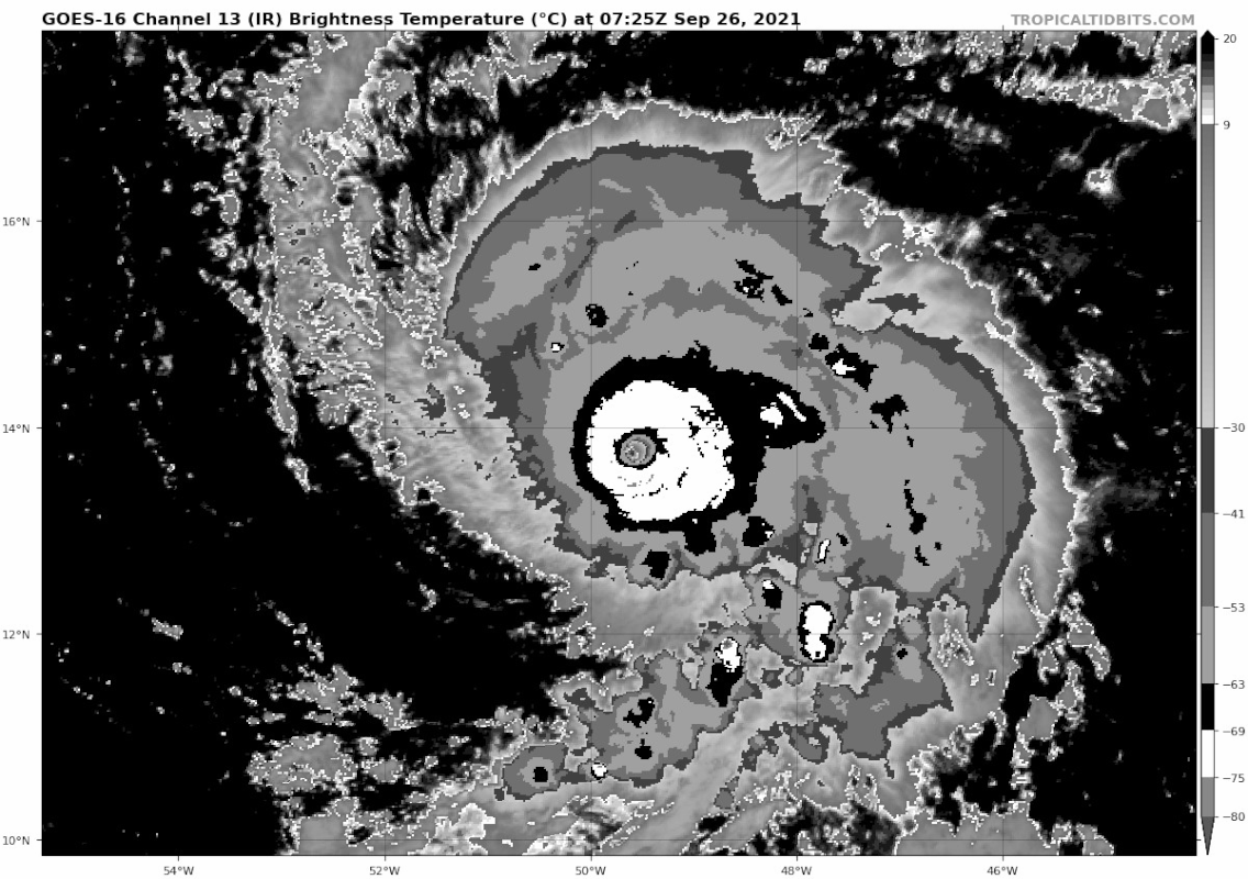
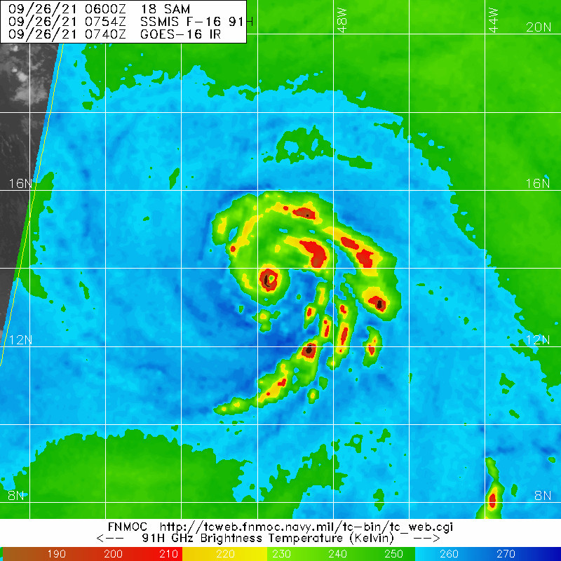
Sam is pulsing up and down. He's looking a tiny bit less impressive on IR now than a few hours ago once recon departed. But I think it's just a natural cycle for Sam, with some luck it will be in a pulse up once recon arrives in ~5 hours if I recall correctly.
0 likes
-
supercane4867
- Category 5
- Posts: 4966
- Joined: Wed Nov 14, 2012 10:43 am

-
beoumont

- Category 1

- Posts: 473
- Joined: Sun Jul 10, 2011 4:13 pm
- Location: East Central Florida
- Contact:
Re: ATL: SAM - Hurricane - Discussion
Yellow Evan wrote:NotoSans wrote:I think the main reason why NHC decided to discard the higher SFMR and dropsonde winds is that they are not recorded in the right front quadrant, where the maximum winds tend to locate. This lends credence to NHC’s claim that these winds are more associated with mesovortices, rather than the overall circulation.
This is not the first time NHC adopts this line of reasoning. Felix’s 162kt SMFR and dropsonde data were rejected for similar reason.
RFQ for a leftward moving system is NW in theory.
Not just in theory. RFQ is RFQ. No alternate realities in science or math.
NHC's Stewart is obviously the most descriptive in his TC Discussions; and weather nuts like when he is on duty. Me included. But this last discussion, I think, was just too verbose; specifically the last paragraph. He kept mentioning all the factors that were inhibiting intensity; while describing a very recently rapidly intensifying 145 mph system; that he forecasts will be 150 mph within 12 hours.
Last edited by beoumont on Sun Sep 26, 2021 3:03 am, edited 3 times in total.
1 likes
List of 79 tropical cyclones intercepted by Richard Horodner:
http://www.canebeard.com/page/page/572246.htm
http://www.canebeard.com/page/page/572246.htm
Re: ATL: SAM - Hurricane - Discussion
Almost crawling now, also resumed intensification.
1 likes
Personal Forecast Disclaimer:
The posts in this forum are NOT official forecast and should not be used as such. They are just the opinion of the poster and may or may not be backed by sound meteorological data. For official information, please refer to the NHC and NWS products.
The posts in this forum are NOT official forecast and should not be used as such. They are just the opinion of the poster and may or may not be backed by sound meteorological data. For official information, please refer to the NHC and NWS products.
Re: ATL: SAM - Hurricane - Discussion
Still no sign of an EWRC so hopefully Sam won't weaken until well after recon arrives.
0 likes
-
grapealcoholic
- Category 2

- Posts: 703
- Joined: Tue Aug 10, 2021 3:26 pm
Re: ATL: SAM - Hurricane - Discussion
For all I care Sam can weaken later today but please let it keep itself together until after recon. It looks incredible now and I just hope recon catches it at its peak.
2 likes
-
grapealcoholic
- Category 2
- Posts: 703
- Joined: Tue Aug 10, 2021 3:26 pm
-
Blown Away

- S2K Supporter

- Posts: 10253
- Joined: Wed May 26, 2004 6:17 am
Re: ATL: SAM - Hurricane - Discussion
Sam’s current CDO could almost fit in Larry’s annular eye. What an intense system, maybe peaks 140-150 knots?
0 likes
Hurricane Eye Experience: David 79, Irene 99, Frances 04, Jeanne 04, Wilma 05… Hurricane Brush Experience: Andrew 92, Erin 95, Floyd 99, Matthew 16, Irma 17, Ian 22, Nicole 22…

Re: ATL: SAM - Hurricane - Discussion
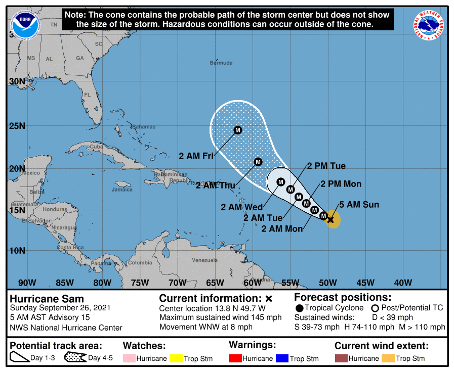
BULLETIN
Hurricane Sam Advisory Number 15
NWS National Hurricane Center Miami FL AL182021
500 AM AST Sun Sep 26 2021
...SAM REMAINS A CATEGORY FOUR HURRICANE...
...FLUCTUATIONS IN INTENSITY LIKELY DURING THE NEXT DAY OR SO...
SUMMARY OF 500 AM AST...0900 UTC...INFORMATION
----------------------------------------------
LOCATION...13.8N 49.7W
ABOUT 940 MI...1510 KM ESE OF THE NORTHERN LEEWARD ISLANDS
MAXIMUM SUSTAINED WINDS...145 MPH...230 KM/H
PRESENT MOVEMENT...WNW OR 295 DEGREES AT 8 MPH...13 KM/H
MINIMUM CENTRAL PRESSURE...943 MB...27.85 INCHES
0 likes
Re: ATL: SAM - Hurricane - Discussion
CDO is rapidly improving with a thick Wring right now.

0 likes
-
grapealcoholic
- Category 2
- Posts: 703
- Joined: Tue Aug 10, 2021 3:26 pm
Re: ATL: SAM - Hurricane - Discussion
Monster.
[img]blob:https://www.tropicaltidbits.com/55dbd2f4-9975-4f85-b001-0f4f71886907[/img]
[img]blob:https://www.tropicaltidbits.com/55dbd2f4-9975-4f85-b001-0f4f71886907[/img]
0 likes

Who is online
Users browsing this forum: No registered users and 27 guests