ATL: SAM - Remnants - Discussion
Moderator: S2k Moderators

Re: ATL: SAM - Hurricane - Discussion
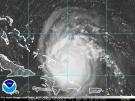
Sam looks to be 125 kt. This means that the NHC’s 125 kt estimate for the very similar Felicia was likely spot-on, despite an extremely smooth W-ring CDO.
4 likes
Irene '11 Sandy '12 Hermine '16 5/15/2018 Derecho Fay '20 Isaias '20 Elsa '21 Henri '21 Ida '21
I am only a meteorology enthusiast who knows a decent amount about tropical cyclones. Look to the professional mets, the NHC, or your local weather office for the best information.
I am only a meteorology enthusiast who knows a decent amount about tropical cyclones. Look to the professional mets, the NHC, or your local weather office for the best information.
-
ElectricStorm

- Category 5

- Posts: 5148
- Age: 25
- Joined: Tue Aug 13, 2019 11:23 pm
- Location: Norman, OK
Re: ATL: SAM - Hurricane - Discussion
About what I expected. Looks about 125kts. Solid storm here.
1 likes
B.S Meteorology, University of Oklahoma '25
Please refer to the NHC, NWS, or SPC for official information.
Please refer to the NHC, NWS, or SPC for official information.


Re: ATL: SAM - Hurricane - Discussion
945mb by dropsonde.
945mb (27.91 inHg) Surface (Sea Level) 26.8°C (80.2°F) 25.3°C (78°F) 120° (from the ESE) 9 knots (10 mph)
945mb (27.91 inHg) Surface (Sea Level) 26.8°C (80.2°F) 25.3°C (78°F) 120° (from the ESE) 9 knots (10 mph)
0 likes

-
Yellow Evan

- Professional-Met

- Posts: 16242
- Age: 27
- Joined: Fri Jul 15, 2011 12:48 pm
- Location: Henderson, Nevada/Honolulu, HI
- Contact:
Re: ATL: SAM - Hurricane - Discussion
Blended SFMR and FL supports 125. Probably stronger in the NE.
0 likes
-
cycloneye

- Admin

- Posts: 149579
- Age: 69
- Joined: Thu Oct 10, 2002 10:54 am
- Location: San Juan, Puerto Rico
Re: ATL: SAM - Hurricane - Discussion
Eye is 9 miles wide.
VORTEX DATA MESSAGE AL182021
A. 25/22:07:46Z
B. 13.29 deg N 048.58 deg W
C. 700 MB 2627 m
D. 945 mb
E. 120 deg 9 kt
F. CLOSED
G. C9
H. 111 kt
I. 273 deg 4 nm 22:06:44Z
J. 358 deg 106 kt
K. 273 deg 4 nm 22:06:49Z
L. 133 kt
M. 095 deg 7 nm 22:09:26Z
N. 177 deg 127 kt
O. 094 deg 9 nm 22:09:53Z
P. 10 C / 3055 m
Q. 27 C / 3050 m
R. 4 C / NA
S. 12345 / 7
T. 0.01 / 1 nm
U. NOAA2 WB18A SAM OB 08
MAX FL WIND 127 KT 094 / 9 NM 22:09:53Z
1 likes
Visit the Caribbean-Central America Weather Thread where you can find at first post web cams,radars
and observations from Caribbean basin members Click Here
and observations from Caribbean basin members Click Here
-
Yellow Evan
- Professional-Met
- Posts: 16242
- Age: 27
- Joined: Fri Jul 15, 2011 12:48 pm
- Location: Henderson, Nevada/Honolulu, HI
- Contact:
-
Iceresistance

- Category 5
- Posts: 9599
- Age: 22
- Joined: Sat Oct 10, 2020 9:45 am
- Location: Tecumseh, OK/Norman, OK
Re: ATL: SAM - Hurricane - Discussion
Thicker Ring of Convection starting to fill the area of warmer clouds from the NE Eyewall to the W Eyewall . . .
1 likes
Bill 2015 & Beta 2020
Winter 2020-2021
All observations are in Tecumseh, OK unless otherwise noted.
Winter posts are focused mainly for Oklahoma & Texas.
Take any of my forecasts with a grain of salt, refer to the NWS, SPC, and NHC for official information
Never say Never with weather! Because ANYTHING is possible!
Winter 2020-2021
All observations are in Tecumseh, OK unless otherwise noted.
Winter posts are focused mainly for Oklahoma & Texas.
Take any of my forecasts with a grain of salt, refer to the NWS, SPC, and NHC for official information
Never say Never with weather! Because ANYTHING is possible!

Re: ATL: SAM - Hurricane - Discussion

Last edited by zzh on Sat Sep 25, 2021 5:44 pm, edited 1 time in total.
3 likes
Re: ATL: SAM - Hurricane - Discussion
Yellow Evan wrote:Blended SFMR and FL supports 125. Probably stronger in the NE.
Hopefully they do a NE to SW pass. They might just do a N to S pass based on their current trajectory.
1 likes
Irene '11 Sandy '12 Hermine '16 5/15/2018 Derecho Fay '20 Isaias '20 Elsa '21 Henri '21 Ida '21
I am only a meteorology enthusiast who knows a decent amount about tropical cyclones. Look to the professional mets, the NHC, or your local weather office for the best information.
I am only a meteorology enthusiast who knows a decent amount about tropical cyclones. Look to the professional mets, the NHC, or your local weather office for the best information.
-
Yellow Evan
- Professional-Met
- Posts: 16242
- Age: 27
- Joined: Fri Jul 15, 2011 12:48 pm
- Location: Henderson, Nevada/Honolulu, HI
- Contact:
-
InfernoFlameCat

- Category 5
- Posts: 2127
- Age: 22
- Joined: Mon Dec 14, 2020 10:52 am
- Location: Buford, GA
Re: ATL: SAM - Hurricane - Discussion
Big convective burst on IR!
1 likes
I am by no means a professional. DO NOT look at my forecasts for official information or make decisions based on what I post.
Goal: to become a registered expert over tropical and subtropical cyclones.
Goal: to become a registered expert over tropical and subtropical cyclones.

Re: ATL: SAM - Hurricane - Discussion
Looks to be improving again on IR after losing some of its Wring in the NW sector. If recon sticks around for a few passes we might be able to get in-storm verification of this improvement.
1 likes
Re: ATL: SAM - Hurricane - Discussion
Probably peaked an hour or two ago. Will probably restrengthen as recon heads out like Eta did last year  Figured it would be anti-climatic. NHC pretty much right on the money.
Last edited by WiscoWx02 on Sat Sep 25, 2021 5:51 pm, edited 1 time in total.
3 likes
-
Yellow Evan
- Professional-Met
- Posts: 16242
- Age: 27
- Joined: Fri Jul 15, 2011 12:48 pm
- Location: Henderson, Nevada/Honolulu, HI
- Contact:
-
Yellow Evan
- Professional-Met
- Posts: 16242
- Age: 27
- Joined: Fri Jul 15, 2011 12:48 pm
- Location: Henderson, Nevada/Honolulu, HI
- Contact:
Re: ATL: SAM - Hurricane - Discussion
----- Current Analysis -----
Date : 25 SEP 2021 Time : 222020 UTC
Lat : 13:18:36 N Lon : 48:30:35 W
CI# /Pressure/ Vmax
6.3 / 946.4mb/122.2kt
Final T# Adj T# Raw T#
6.3 6.2 6.2
Estimated radius of max. wind based on IR : 13 km
Center Temp : +16.7C Cloud Region Temp : -66.3C
Scene Type : EYE
Date : 25 SEP 2021 Time : 222020 UTC
Lat : 13:18:36 N Lon : 48:30:35 W
CI# /Pressure/ Vmax
6.3 / 946.4mb/122.2kt
Final T# Adj T# Raw T#
6.3 6.2 6.2
Estimated radius of max. wind based on IR : 13 km
Center Temp : +16.7C Cloud Region Temp : -66.3C
Scene Type : EYE
0 likes
-
Iceresistance
- Category 5
- Posts: 9599
- Age: 22
- Joined: Sat Oct 10, 2020 9:45 am
- Location: Tecumseh, OK/Norman, OK
Re: ATL: SAM - Hurricane - Discussion
CAT 5 Winds in the upper levels, has not mixed down yet . . .

1 likes
Bill 2015 & Beta 2020
Winter 2020-2021
All observations are in Tecumseh, OK unless otherwise noted.
Winter posts are focused mainly for Oklahoma & Texas.
Take any of my forecasts with a grain of salt, refer to the NWS, SPC, and NHC for official information
Never say Never with weather! Because ANYTHING is possible!
Winter 2020-2021
All observations are in Tecumseh, OK unless otherwise noted.
Winter posts are focused mainly for Oklahoma & Texas.
Take any of my forecasts with a grain of salt, refer to the NWS, SPC, and NHC for official information
Never say Never with weather! Because ANYTHING is possible!
-
Yellow Evan
- Professional-Met
- Posts: 16242
- Age: 27
- Joined: Fri Jul 15, 2011 12:48 pm
- Location: Henderson, Nevada/Honolulu, HI
- Contact:
-
cycloneye
- Admin
- Posts: 149579
- Age: 69
- Joined: Thu Oct 10, 2002 10:54 am
- Location: San Juan, Puerto Rico
Re: ATL: SAM - Hurricane - Discussion
aspen wrote:Yellow Evan wrote:Blended SFMR and FL supports 125. Probably stronger in the NE.
Hopefully they do a NE to SW pass. They might just do a N to S pass based on their current trajectory.
From NE to SW.

0 likes
Visit the Caribbean-Central America Weather Thread where you can find at first post web cams,radars
and observations from Caribbean basin members Click Here
and observations from Caribbean basin members Click Here
-
skyline385

- Category 5
- Posts: 2728
- Age: 35
- Joined: Wed Aug 26, 2020 11:15 pm
- Location: Houston TX
Re: ATL: SAM - Hurricane - Discussion
Yellow Evan wrote:https://twitter.com/andrewhagen/status/1441895264357216257?s=21
Kinda surprised that a Met at NHC isnt sure if the SFMR were fixed...
1 likes
Who is online
Users browsing this forum: No registered users and 20 guests