zzh wrote:AL, 18, 2021092518, , BEST, 0, 131N, 481W, 115, 948, HU,
"Cat 4-I-am."
Moderator: S2k Moderators

zzh wrote:AL, 18, 2021092518, , BEST, 0, 131N, 481W, 115, 948, HU,


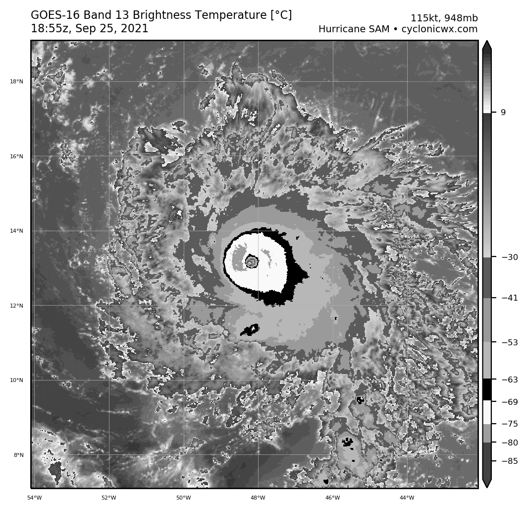
Yellow Evan wrote:https://usercontent.irccloud-cdn.com/file/hEb108kv/goes16_18L_dvorak_202109251855-1.png
I’m a little confused why the eye warmth isn’t uniform. This might be a sign of the storm that’s weaker than Dvorak or it might just be an issue with the viewing angle (we’ve seen a similar problem in other basins). Otherwise, this has the classic Category 5 satellite presentation.

CrazyC83 wrote:Yellow Evan wrote:https://usercontent.irccloud-cdn.com/file/hEb108kv/goes16_18L_dvorak_202109251855-1.png
I’m a little confused why the eye warmth isn’t uniform. This might be a sign of the storm that’s weaker than Dvorak or it might just be an issue with the viewing angle (we’ve seen a similar problem in other basins). Otherwise, this has the classic Category 5 satellite presentation.
That is likely viewing angle issue. A warmer eye would easily be T7.0 with some CMG showing. I'd personally estimate the intensity at 125 kt, but we will know the truth in about 2 hours or so.

supercane4867 wrote:Stadium effect becoming visible. My 140kt+ peak prediction about to materialize
https://i.imgur.com/9X7LFYN.jpg
Iceresistance wrote:WMG has been officially detected . . . It's now a T7.0 based on that . . .
https://s9.gifyu.com/images/GOES16_1km_ir_202109251825_8.50_17.00_-53.75_-39.75_bd1_ltng16_hgwy_warn_latlon_weathernerds.png

hipshot wrote:Iceresistance wrote:WMG has been officially detected . . . It's now a T7.0 based on that . . .
https://s9.gifyu.com/images/GOES16_1km_ir_202109251825_8.50_17.00_-53.75_-39.75_bd1_ltng16_hgwy_warn_latlon_weathernerds.png
Folks, what is this WMG stuff I've been reading in the posts. I'm not a weather guy but I like to follow this stuff.
Thks.


kevin wrote:Wow, what a perfect looking hurricane
https://cdn.star.nesdis.noaa.gov/FLOATER/data/AL182021/GEOCOLOR/20212681900_GOES16-ABI-FL-GEOCOLOR-AL182021-500x500.jpg

WiscoWx02 wrote:I think a category 5 peak intensity is likely at this point. Be willing to bet money though that by the time recon gets there, they will find that it has significantly weakened, so will never see the official designation.
Weather Dude wrote:WiscoWx02 wrote:I think a category 5 peak intensity is likely at this point. Be willing to bet money though that by the time recon gets there, they will find that it has significantly weakened, so will never see the official designation.
Recon is on the way. I don't really see this weakening at all between now and then
Users browsing this forum: No registered users and 30 guests


