ATL: SAM - Models
Moderator: S2k Moderators
-
Category5Kaiju

- Category 5

- Posts: 4338
- Joined: Thu Dec 24, 2020 12:45 pm
- Location: Seattle during the summer, Phoenix during the winter
Re: ATL: INVEST 98L - Models
It's honestly stunning to see how we are potentially going to see a very potent Cabo Verde hurricane threaten the islands and even possibly the CONUS...in late September/early October. This is something that you definitely do not expect months in advance, let alone in a given hurricane season (not even big bad MDR years like 2004 or 2017 had something like this). But hey, each season has its own unique tricks and quirks, so perhaps 2021's quirk will be this?
8 likes
Unless explicitly stated, all information in my posts is based on my own opinions and observations. Tropical storms and hurricanes can be extremely dangerous. Refer to an accredited weather research agency or meteorologist if you need to make serious decisions regarding an approaching storm.

Re: ATL: INVEST 98L - Models
Category5Kaiju wrote:It's honestly stunning to see how we are potentially going to see a very potent Cabo Verde hurricane threaten the islands and even possibly the CONUS...in late September/early October. This is something that you definitely do not expect months in advance, let alone in a given hurricane season (not even big bad MDR years like 2004 or 2017 had something like this). But hey, each season has its own unique tricks and quirks, so perhaps 2021's quirk will be this?
Georges 1998 seems like a good analog if this plays out, in fact if it forms tomorrow we're only a week later than Georges was.
2 likes
The above post is not official and should not be used as such. It is the opinion of the poster and may or may not be backed by sound meteorological data. It is not endorsed by any professional institution or storm2k.org. For official information, please refer to the NHC and NWS products.

Re: ATL: INVEST 98L - Models
sma10 wrote:LarryWx wrote:sma10 wrote:
Larry, you are the "go-to guru" on this type of stuff: the Euro has 98L tracking W to WNW on 10/1 off the N coast of Hispaniola towards the Bahamas. When is the last time you can remember an October storm in that region tracking westerly? Would we have to go all the way back to Inez? Or maybe Kate?
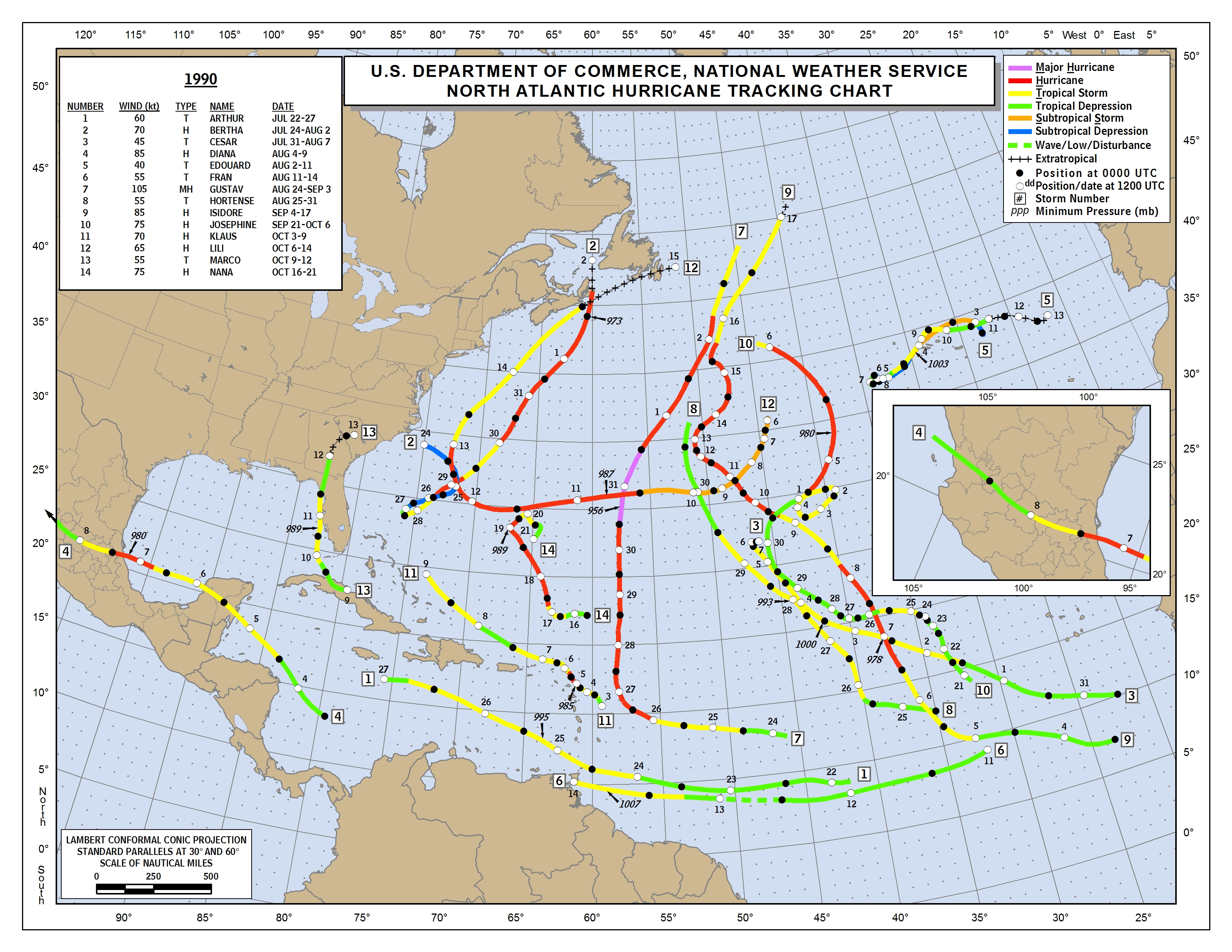
Klaus 1990:
https://www.nhc.noaa.gov/data/tracks/tracks-at-1990.png
Thank you, wow 31 years. And I doubt this one is just going to fizzle away like Klaus
YW.
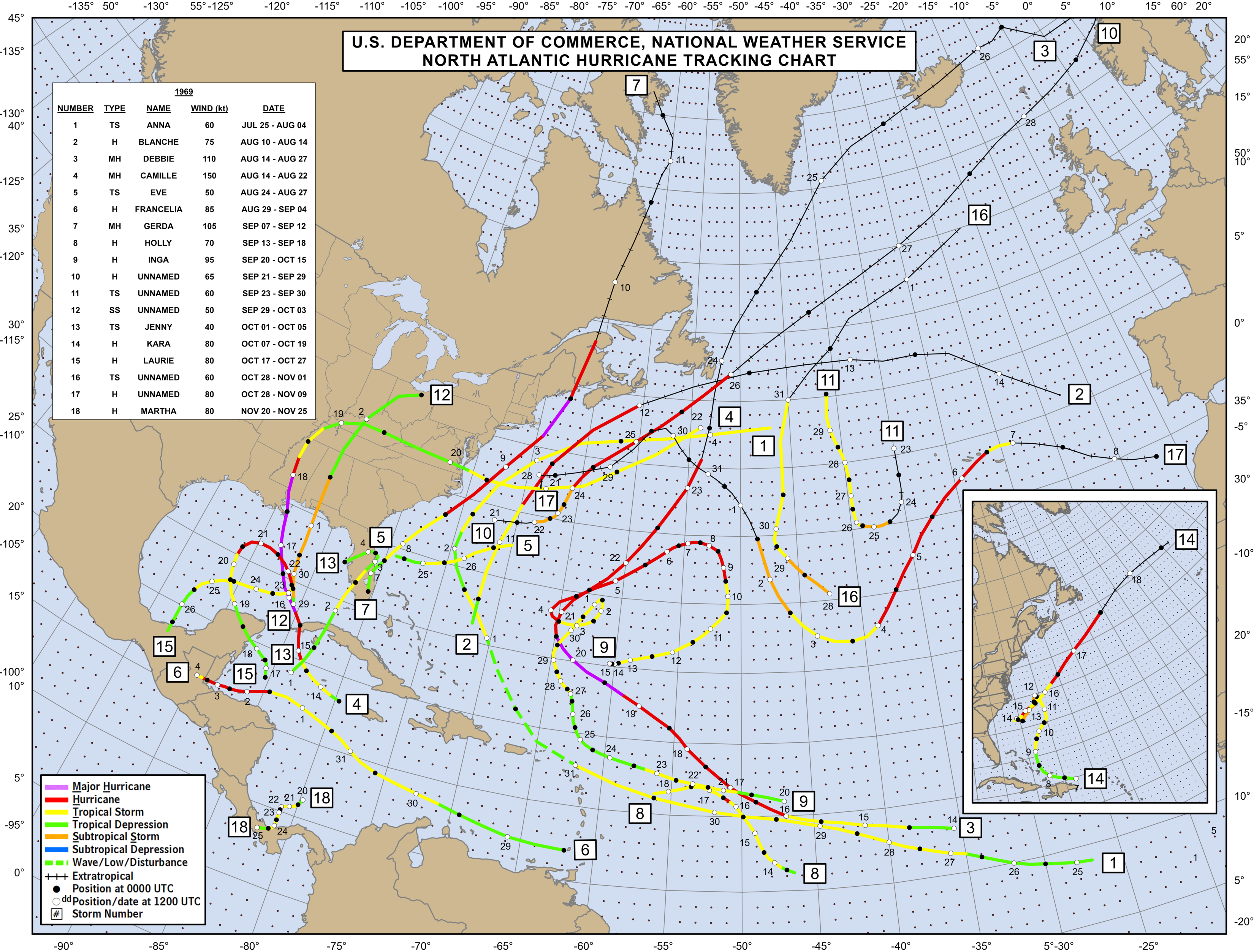
Back to 1900, then is Kate of 1985. Then Kara of 1969:
https://www.nhc.noaa.gov/data/tracks/tracks-at-1969.png
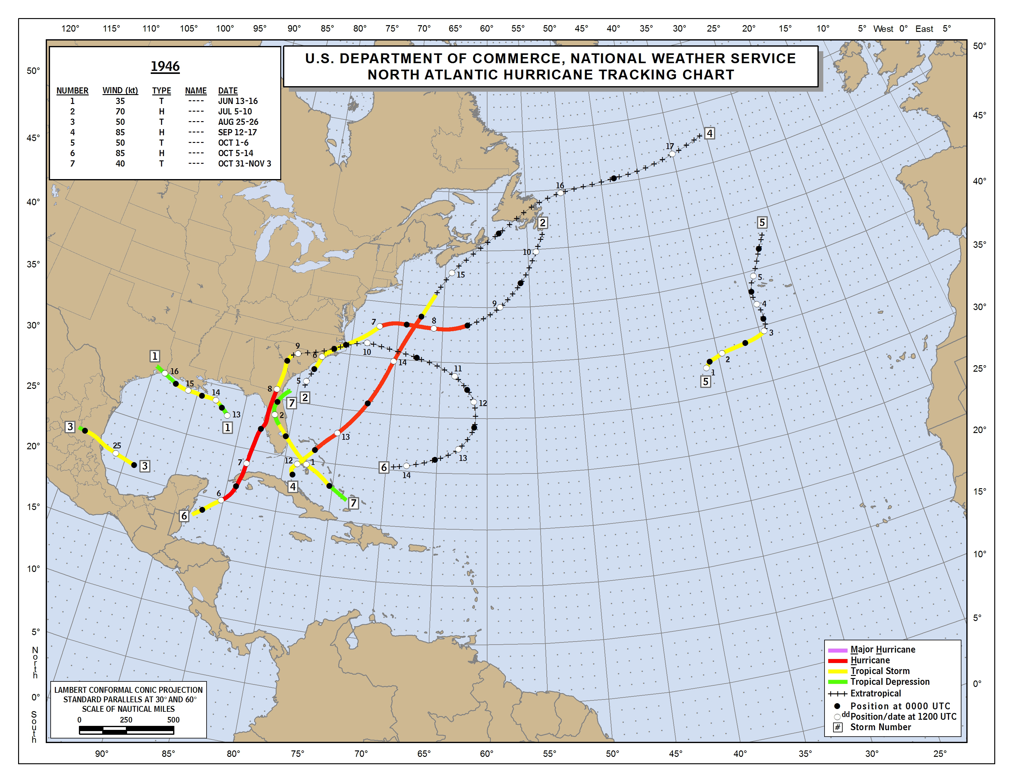
#7 of 1946:
https://www.nhc.noaa.gov/data/tracks/tracks-at-1946.png
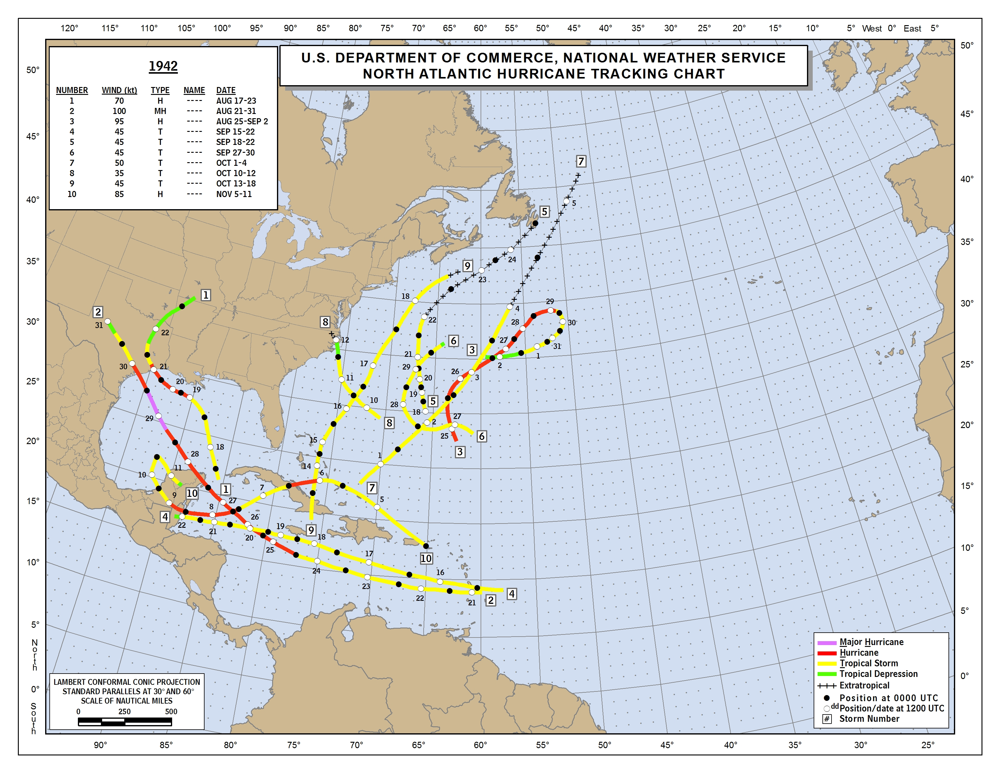
#10 of 1942
https://www.nhc.noaa.gov/data/tracks/tracks-at-1942.png
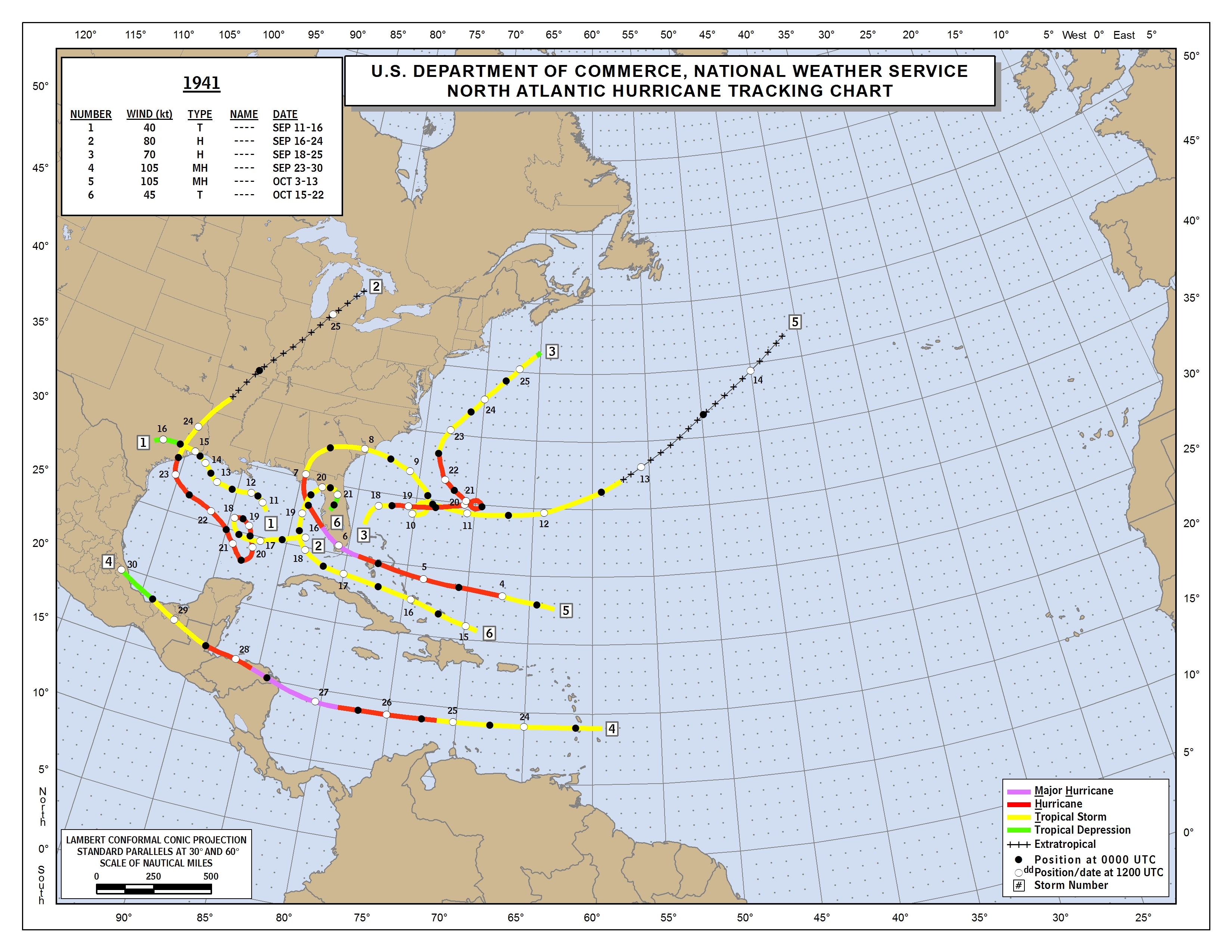
#5 and #6 of 1941:
https://www.nhc.noaa.gov/data/tracks/tracks-at-1941.png
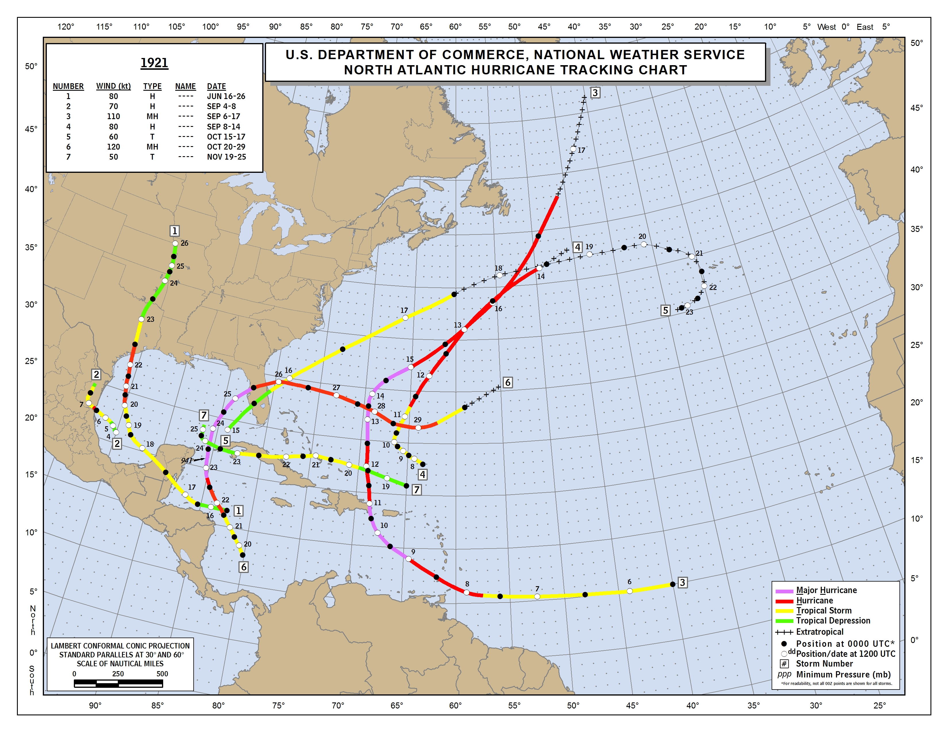
#7 of 1921:
https://www.nhc.noaa.gov/data/tracks/tracks-at-1921.png
Edit for before 1900:
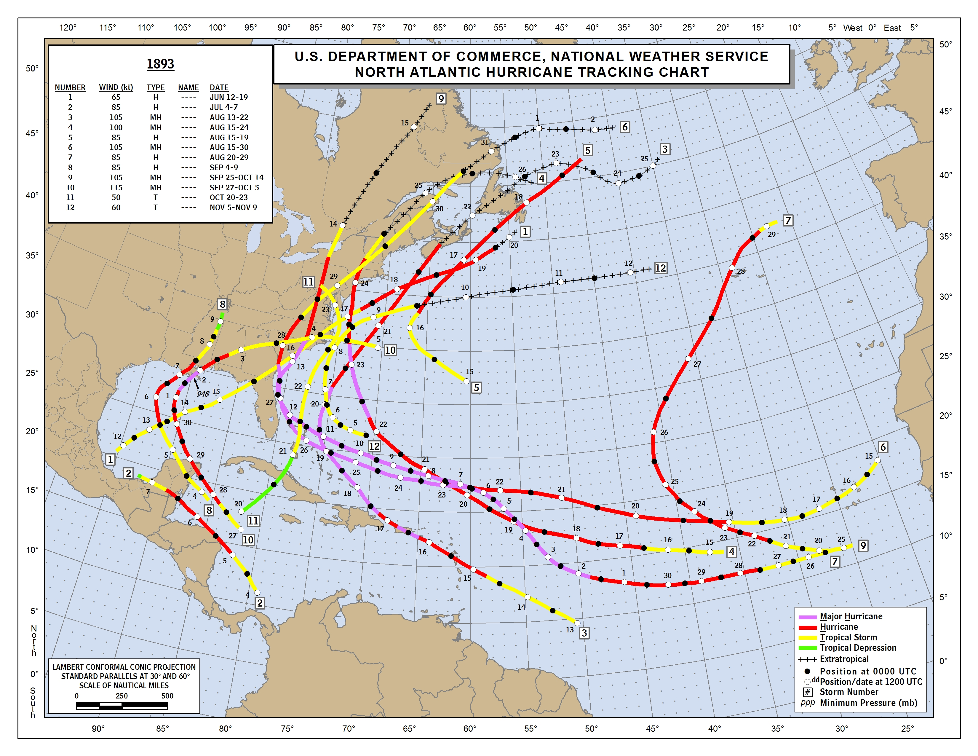
#9 1893: was a H that had major US impact:
https://www.nhc.noaa.gov/data/tracks/tracks-at-1893.png
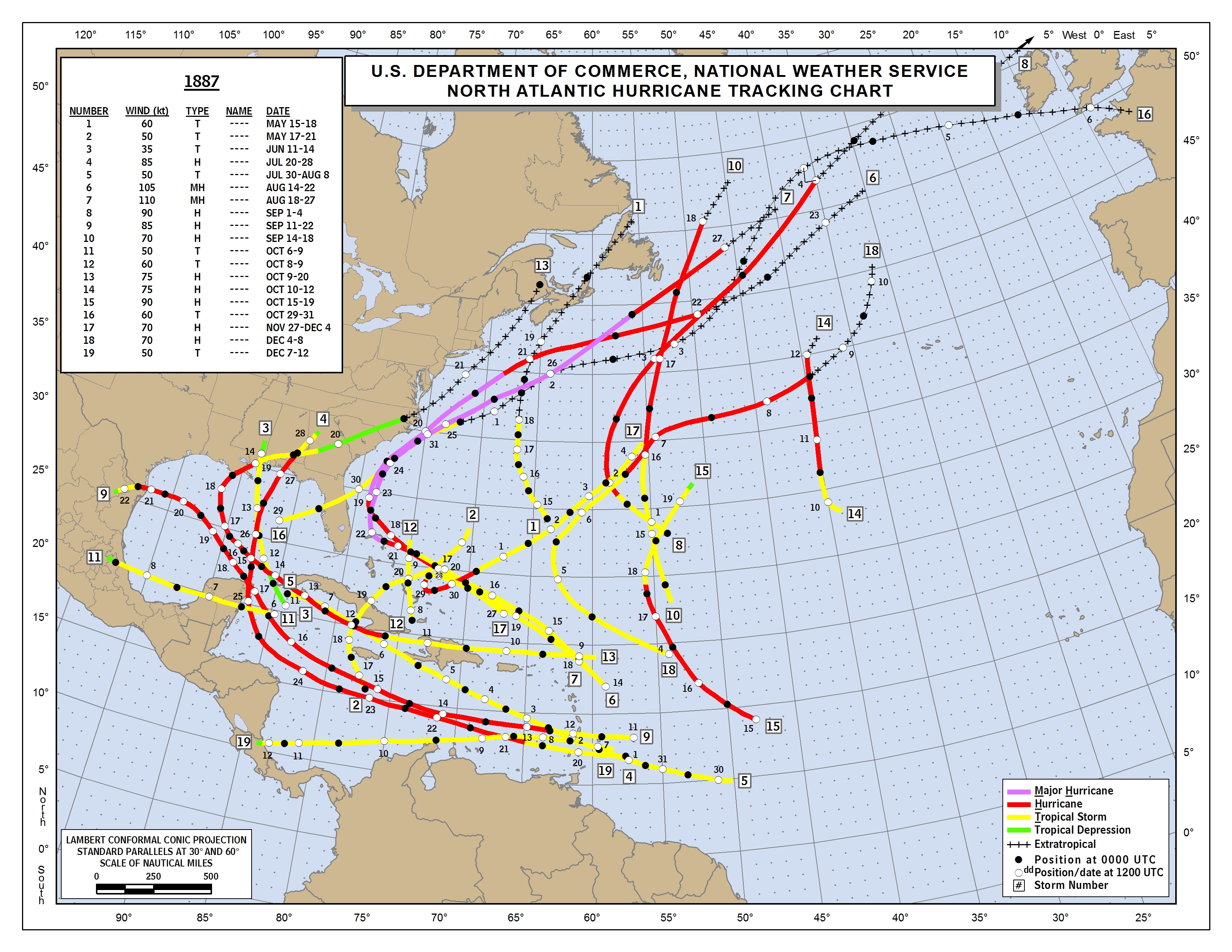
#17 of 1887:
https://www.nhc.noaa.gov/data/tracks/tracks-at-1887.png
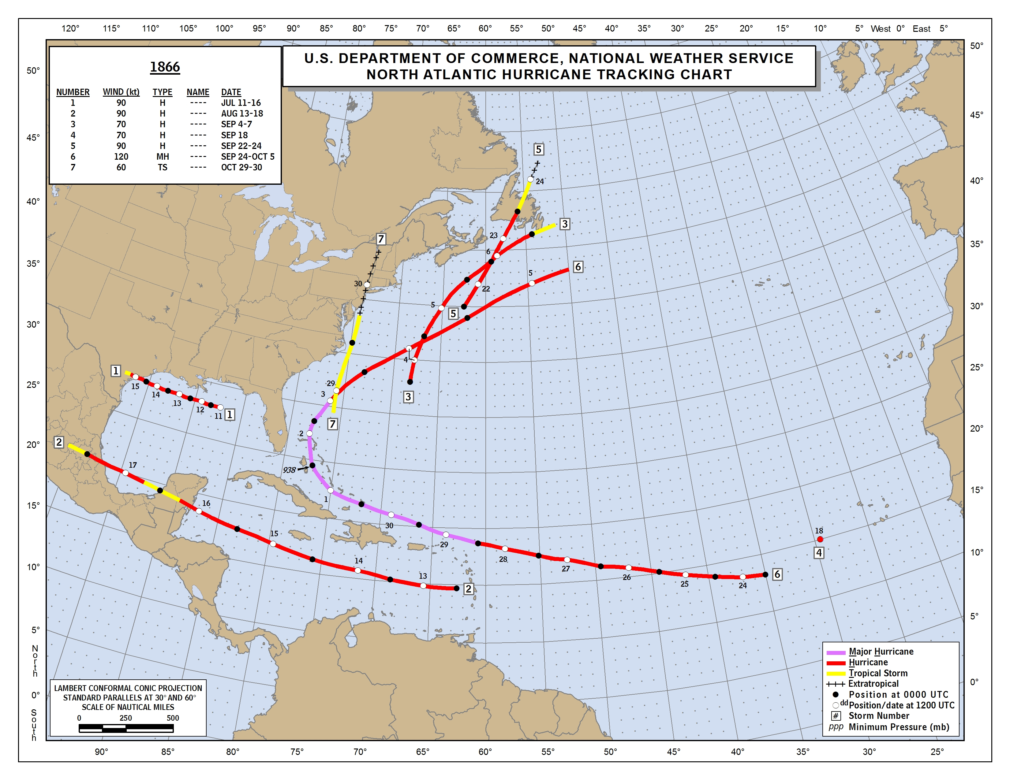
# 6 of 1866: was a MH then and missed the US:
https://www.nhc.noaa.gov/data/tracks/tracks-at-1866.png
So, total of 11 since 1851 or once every 15 years.
4 of the 11 were 'canes there: Kate of 1985, #5 of 1941, #9 of 1893, and #6 of 1866. So, one every 40 or so years. All but 1866 had major CONUS impact.
Last edited by LarryWx on Tue Sep 21, 2021 11:08 pm, edited 9 times in total.
0 likes
Personal Forecast Disclaimer:
The posts in this forum are NOT official forecasts and should not be used as such. They are just the opinion of the poster and may or may not be backed by sound meteorological data. They are NOT endorsed by any professional institution or storm2k.org. For official information, please refer to the NHC and NWS products.
The posts in this forum are NOT official forecasts and should not be used as such. They are just the opinion of the poster and may or may not be backed by sound meteorological data. They are NOT endorsed by any professional institution or storm2k.org. For official information, please refer to the NHC and NWS products.

Re: ATL: INVEST 98L - Models
Category5Kaiju wrote:It's honestly stunning to see how we are potentially going to see a very potent Cabo Verde hurricane threaten the islands and even possibly the CONUS...in late September/early October. This is something that you definitely do not expect months in advance, let alone in a given hurricane season (not even big bad MDR years like 2004 or 2017 had something like this). But hey, each season has its own unique tricks and quirks, so perhaps 2021's quirk will be this?
Why not? On a day like today Puerto Rico was getting hammered by Georges in 1998. Not a surprise at all and I really think this is one is going to be a closed call for the Antilles specially for Puerto Rico.
1 likes

Re: ATL: INVEST 98L - Models
Did anyone else think we would get through the whole list two seasons in a row lol
I know I’m jumping the gun, but with only three storms left after Sam, I think it’s a safe jump to make.
I know I’m jumping the gun, but with only three storms left after Sam, I think it’s a safe jump to make.
5 likes
Re: ATL: INVEST 98L - Models
Hammy wrote:Category5Kaiju wrote:It's honestly stunning to see how we are potentially going to see a very potent Cabo Verde hurricane threaten the islands and even possibly the CONUS...in late September/early October. This is something that you definitely do not expect months in advance, let alone in a given hurricane season (not even big bad MDR years like 2004 or 2017 had something like this). But hey, each season has its own unique tricks and quirks, so perhaps 2021's quirk will be this?
I’m 100% agree with you. And I was in Puerto Rico when Georges.
Georges 1998 seems like a good analog if this plays out, in fact if it forms tomorrow we're only a week later than Georges was.
0 likes
-
ElectricStorm

- Category 5
- Posts: 5148
- Age: 25
- Joined: Tue Aug 13, 2019 11:23 pm
- Location: Norman, OK
Re: ATL: INVEST 98L - Models
FWIW the 0z ICON is much stronger so far than it's previous runs. Peaked in the upper 990's on the 18z run but it's already down to 972mb at hour 138. I know the ICON doesn't mean much, but that's yet another model showing a strong storm coming in threatening the islands.
EDIT: 966mb at the end of the run
EDIT: 966mb at the end of the run
0 likes
B.S Meteorology, University of Oklahoma '25
Please refer to the NHC, NWS, or SPC for official information.
Please refer to the NHC, NWS, or SPC for official information.

Re: ATL: INVEST 98L - Models
Weather Dude wrote:FWIW the 0z ICON is much stronger so far than it's previous runs. Peaked in the upper 990's on the 18z run but it's already down to 972mb at hour 138. I know the ICON doesn't mean much, but that's yet another model showing a strong storm coming in threatening the islands.
Keep in mind the 6/18z ICON only go out to h120 instead of h180. By h177, this run is identical in intensity to the 12z (964).
0 likes
Kendall -> SLO -> PBC
Memorable Storms: Katrina (for its Florida landfall...) Wilma Matthew Irma
Memorable Storms: Katrina (for its Florida landfall...) Wilma Matthew Irma
-
skyline385

- Category 5
- Posts: 2728
- Age: 35
- Joined: Wed Aug 26, 2020 11:15 pm
- Location: Houston TX
Re: ATL: INVEST 98L - Models
Weather Dude wrote:FWIW the 0z ICON is much stronger so far than it's previous runs. Peaked in the upper 990's on the 18z run but it's already down to 972mb at hour 138. I know the ICON doesn't mean much, but that's yet another model showing a strong storm coming in threatening the islands.
EDIT: 966mb at the end of the run
ICON is like one of the most conservative models out there, never good when even it is dropping down to 966mb. What was the last system ICON was so bullish about? Ida?
Last edited by skyline385 on Tue Sep 21, 2021 10:51 pm, edited 3 times in total.
0 likes
Re: ATL: INVEST 98L - Models
Fancy1001 wrote:Did anyone else think we would get through the whole list two seasons in a row lol
I know I’m jumping the gun, but with only three storms left after Sam, I think it’s a safe jump to make.
I'm sure no one was lol - but in hindsight the warning signs were there even back in 2019 when it ended up with 20 tropical systems and 18 NS (3 names from exhausting the list) despite one of the slowest starts in recent memory. Since October and November typically produces around 3-5 storms, I wouldn't be surprised if we ended on Adria or Braylen.
Given all the name lists in the NATL have all reached the letter "T" at some point (assuming the season doesn't end on Sam), I wouldn't be surprised if we scrape the top of the auxiliary list more frequently in future years as well. Ending up with 22 or 23 NS a season doesn't seem too unreasonable if a season has favorable conditions, especially with our better detection.
Anyway, regarding the models for 98L, it's also important to note that 99W in the WPAC could potentially affect the future track of 98L as well (in addition to the fact that 98L doesn't have a well-defined center yet). Still a lot of outcomes still on the table, and also a potential for more windshield wipers from the models over the next few days.
4 likes

Re: ATL: INVEST 98L - Models
0z GFS has intensification much sooner, already down to 982 mb at 78 hours.
Probably not Peter 2.0 at this point lol.
Probably not Peter 2.0 at this point lol.
0 likes
TC naming lists: retirements and intensity
Most aggressive Advisory #1's in North Atlantic (cr. kevin for starting the list)
Most aggressive Advisory #1's in North Atlantic (cr. kevin for starting the list)
-
skyline385
- Category 5
- Posts: 2728
- Age: 35
- Joined: Wed Aug 26, 2020 11:15 pm
- Location: Houston TX
-
AutoPenalti
- Category 5
- Posts: 4091
- Age: 29
- Joined: Mon Aug 17, 2015 4:16 pm
- Location: Ft. Lauderdale, Florida
Re: ATL: INVEST 98L - Models
Further north though, so likely a closer OTS run.
0 likes
The posts in this forum are NOT official forecasts and should not be used as such. They are just the opinion of the poster and may or may not be backed by sound meteorological data. They are NOT endorsed by any professional institution or STORM2K. For official information, please refer to products from the NHC and NWS.
Model Runs Cheat Sheet:
GFS (5:30 AM/PM, 11:30 AM/PM)
HWRF, GFDL, UKMET, NAVGEM (6:30-8:00 AM/PM, 12:30-2:00 AM/PM)
ECMWF (1:45 AM/PM)
TCVN is a weighted averaged
Re: ATL: INVEST 98L - Models
Hugo1989 wrote:Category5Kaiju wrote:It's honestly stunning to see how we are potentially going to see a very potent Cabo Verde hurricane threaten the islands and even possibly the CONUS...in late September/early October. This is something that you definitely do not expect months in advance, let alone in a given hurricane season (not even big bad MDR years like 2004 or 2017 had something like this). But hey, each season has its own unique tricks and quirks, so perhaps 2021's quirk will be this?
Why not? On a day like today Puerto Rico was getting hammered by Georges in 1998. Not a surprise at all and I really think this is one is going to be a closed call for the Antilles specially for Puerto Rico.
Georges was 23 years ago and Maria was 4 years ago. Those are the only two times I can remember in the last 25 years and Georges formed on September 15th while Maria formed on September 16th. 98L hasn't even formed yet as of September 22nd so it would be even rarer than Georges or Maria if it manages to effect land.
0 likes
-
AutoPenalti
- Category 5
- Posts: 4091
- Age: 29
- Joined: Mon Aug 17, 2015 4:16 pm
- Location: Ft. Lauderdale, Florida
Re: ATL: INVEST 98L - Models
lmao, GFS forms a cut off low.
2 likes
The posts in this forum are NOT official forecasts and should not be used as such. They are just the opinion of the poster and may or may not be backed by sound meteorological data. They are NOT endorsed by any professional institution or STORM2K. For official information, please refer to products from the NHC and NWS.
Model Runs Cheat Sheet:
GFS (5:30 AM/PM, 11:30 AM/PM)
HWRF, GFDL, UKMET, NAVGEM (6:30-8:00 AM/PM, 12:30-2:00 AM/PM)
ECMWF (1:45 AM/PM)
TCVN is a weighted averaged
-
Keldeo1997
- Category 2

- Posts: 688
- Joined: Fri Oct 11, 2019 11:35 pm

-
grapealcoholic
- Category 2
- Posts: 703
- Joined: Tue Aug 10, 2021 3:26 pm
Re: ATL: INVEST 98L - Models
Keldeo1997 wrote:https://cdn.discordapp.com/attachments/752166055501365319/890091828248989776/gfs_z500a_atl_fh174_trend.gif
Big changes to the Trough
Don't like these trends
0 likes
-
AutoPenalti
- Category 5
- Posts: 4091
- Age: 29
- Joined: Mon Aug 17, 2015 4:16 pm
- Location: Ft. Lauderdale, Florida
Re: ATL: INVEST 98L - Models
grapealcoholic wrote:Keldeo1997 wrote:https://cdn.discordapp.com/attachments/752166055501365319/890091828248989776/gfs_z500a_atl_fh174_trend.gif
Big changes to the Trough
Don't like these trends
It’s a good trend for OTS tracks.
0 likes
The posts in this forum are NOT official forecasts and should not be used as such. They are just the opinion of the poster and may or may not be backed by sound meteorological data. They are NOT endorsed by any professional institution or STORM2K. For official information, please refer to products from the NHC and NWS.
Model Runs Cheat Sheet:
GFS (5:30 AM/PM, 11:30 AM/PM)
HWRF, GFDL, UKMET, NAVGEM (6:30-8:00 AM/PM, 12:30-2:00 AM/PM)
ECMWF (1:45 AM/PM)
TCVN is a weighted averaged
-
grapealcoholic
- Category 2
- Posts: 703
- Joined: Tue Aug 10, 2021 3:26 pm
Re: ATL: INVEST 98L - Models
AutoPenalti wrote:grapealcoholic wrote:Keldeo1997 wrote:https://cdn.discordapp.com/attachments/752166055501365319/890091828248989776/gfs_z500a_atl_fh174_trend.gif
Big changes to the Trough
Don't like these trends
It’s a good trend for OTS tracks.
A strong cutoff low would pivot the storm NW into CONUS
4 likes
-
AutoPenalti
- Category 5
- Posts: 4091
- Age: 29
- Joined: Mon Aug 17, 2015 4:16 pm
- Location: Ft. Lauderdale, Florida
Re: ATL: INVEST 98L - Models
grapealcoholic wrote:AutoPenalti wrote:grapealcoholic wrote:Don't like these trends
It’s a good trend for OTS tracks.
A strong cutoff low would pivot the storm NW into CONUS

0 likes
The posts in this forum are NOT official forecasts and should not be used as such. They are just the opinion of the poster and may or may not be backed by sound meteorological data. They are NOT endorsed by any professional institution or STORM2K. For official information, please refer to products from the NHC and NWS.
Model Runs Cheat Sheet:
GFS (5:30 AM/PM, 11:30 AM/PM)
HWRF, GFDL, UKMET, NAVGEM (6:30-8:00 AM/PM, 12:30-2:00 AM/PM)
ECMWF (1:45 AM/PM)
TCVN is a weighted averaged
Who is online
Users browsing this forum: No registered users and 11 guests