wow! Looks like a giant tornado passed thru there!Sanibel wrote:West eyewall destruction at Cocodrie just as bad as east...
Textbook high end category 4 wind and surge destruction...Note straight wind destruction on structures above surge:
https://www.youtube.com/watch?v=LYYtrx5nmJA
ATL: IDA - Remnants - Discussion
Moderator: S2k Moderators
-
otowntiger
- Category 5

- Posts: 1932
- Joined: Tue Aug 31, 2004 7:06 pm
Re: ATL: IDA - Tropical Depression - Discussion
0 likes
-
talkinggoat
- Tropical Wave

- Posts: 4
- Joined: Mon Sep 03, 2018 11:24 pm
Re: ATL: IDA - Tropical Depression - Discussion
Analysis of Models? Which models were the most accurate in terms of timing, intensity and location, both separately and alone. I find the Canadian, although not the first to predict the general area, was the first to predict a landfall near port Fourchon, maintained the general area and was the most accurate in timing, overall. It completely failed to predict the intensity, however. The GFS was the first to predict a Louisiana landfall but wobbled between Vermillion bay and Fourchon. The Euro was lost, pretty much up to the end and none of the major Global models predicted the pressure correctly. I can't go back on Tropical Tidbits long enough to see what the HWRF and HMON predicted.
0 likes
Re: ATL: IDA - Tropical Depression - Discussion
talkinggoat wrote:Analysis of Models? Which models were the most accurate in terms of timing, intensity and location, both separately and alone. I find the Canadian, although not the first to predict the general area, was the first to predict a landfall near port Fourchon, maintained the general area and was the most accurate in timing, overall. It completely failed to predict the intensity, however. The GFS was the first to predict a Louisiana landfall but wobbled between Vermillion bay and Fourchon. The Euro was lost, pretty much up to the end and none of the major Global models predicted the pressure correctly. I can't go back on Tropical Tidbits long enough to see what the HWRF and HMON predicted.
Euro was actually the first major model to show a Louisana landfall.
12Z Euro run on Tuesday, August 24th

12Z GFS on Tuesday, August 24th

12Z CMC on Tuesday, August 24th

4 likes
-
InfernoFlameCat

- Category 5
- Posts: 2127
- Age: 22
- Joined: Mon Dec 14, 2020 10:52 am
- Location: Buford, GA
Re: ATL: IDA - Tropical Depression - Discussion
CrazyC83 wrote:Good riddance, Ida. You're heading to one place only: the. Won't be seeing you in 2027!
Lol Ida is still a depression even though best track suggested otherwise.
0 likes
I am by no means a professional. DO NOT look at my forecasts for official information or make decisions based on what I post.
Goal: to become a registered expert over tropical and subtropical cyclones.
Goal: to become a registered expert over tropical and subtropical cyclones.

Re: ATL: IDA - Tropical Depression - Discussion
TallyTracker wrote:jlauderdal wrote:FireRat wrote:On a good note, at least so far, there seems to have been very few deaths during hurricane Ida. 2 so far, does anyone know just how populated the region worst hit by the surge and Cat 4 winds was? Perhaps this is a result of very successful evacuation & rescue operations, or on the contrary limited access to the worst hit areas? Time will tell but so far this seems to be a silver lining, maybe Ida was more about material destruction but with a low death toll instead, hopefully.
Usually, deaths post-hurricane are heart attacks during the cleanup, carbon monoxide poisoning, and electrocution. However, walking around floodwaters is never a good idea but plenty of peeps do it. This guy was attacked by an alligator and as alligators like to do, they take their prey and leave the scene.
https://www.wwltv.com/article/weather/h ... 56cf33a02c
Absolutely! My cousin died about 8 days after Michael when he was trying to cut down a half fallen tree by himself. There were a lot of deaths in Bay County in the days after Michael hit unfortunately. I hope people are careful after Ida and avoid the fatal mistakes that are too common after hurricane disasters.
Oh wow, sorry about your cousin TallyTracker
That really is sad, and goes to show how dangerous the aftermath can be as well. Jlauderdal that story about the gator is nuts, that poor fella, dang.
0 likes
Georges '98, Irene '99, Frances '04, Jeanne '04, Katrina '05, Wilma '05, Gustav '08, Isaac '12, Matthew '16, Florence '18, Michael '18, Ian '22

Re: ATL: IDA - Tropical Depression - Discussion
This has to be one longest lingering tropical systems after final landfall in recent times right? It's been like 3 days since landfall and somehow Ida is still a tropical depression. Can't recall the last time something like that happened.
3 likes


Re: ATL: IDA - Tropical Depression - Discussion
IcyTundra wrote:talkinggoat wrote:Analysis of Models? Which models were the most accurate in terms of timing, intensity and location, both separately and alone. I find the Canadian, although not the first to predict the general area, was the first to predict a landfall near port Fourchon, maintained the general area and was the most accurate in timing, overall. It completely failed to predict the intensity, however. The GFS was the first to predict a Louisiana landfall but wobbled between Vermillion bay and Fourchon. The Euro was lost, pretty much up to the end and none of the major Global models predicted the pressure correctly. I can't go back on Tropical Tidbits long enough to see what the HWRF and HMON predicted.
Euro was actually the first major model to show a Louisana landfall.
12Z Euro run on Tuesday, August 24th
https://i.ibb.co/MNxFpkx/ecmwf-z500-mslp-watl-fh72-168.gif
12Z GFS on Tuesday, August 24th
https://i.imgur.com/YQaNxdX.png
12Z CMC on Tuesday, August 24th
https://i.ibb.co/gD19fXD/gem-z500-mslp-watl-fh66-156.gif
Yes, the Euro was the first global to sniff a more northerly track into LA. I believe the ICON was also right along with the Euro or shortly after.
After the other global models latched on, the Euro became too west biased, showing landfall between Morgan City and Lafayette, the ICON also went along with the Euro at one time showing landfall west of Lafayette.
The Canadian was right biased, landfall near Grand Isle up straight to Nola but at the end it did not do too bad with its consistency that it was going to make landfall on the right side of the consensus.
The GFS in the shorter term did better than the Euro not only in track but in timing. I remember the GFS being dismissed because it was showing landfall around noon on Monday when the Euro was showing early Tuesday morning to late Monday evening.
The HWRF and HMON were left biased run after run.
HMON was horrible with the strength forecast.
2 likes
Re: ATL: IDA - Tropical Depression - Discussion
Whoever thought damage was not too bad in Grand Isle, think again.
https://twitter.com/weatherdak/status/1432942904444551173
https://twitter.com/ericblake12/status/1433040041664782337
https://twitter.com/weatherdak/status/1432942904444551173
https://twitter.com/ericblake12/status/1433040041664782337
Last edited by NDG on Wed Sep 01, 2021 7:40 am, edited 1 time in total.
3 likes
-
tolakram
- Admin

- Posts: 20186
- Age: 62
- Joined: Sun Aug 27, 2006 8:23 pm
- Location: Florence, KY (name is Mark)
Re: ATL: IDA - Tropical Depression - Discussion
IcyTundra wrote:talkinggoat wrote:Analysis of Models? Which models were the most accurate in terms of timing, intensity and location, both separately and alone. I find the Canadian, although not the first to predict the general area, was the first to predict a landfall near port Fourchon, maintained the general area and was the most accurate in timing, overall. It completely failed to predict the intensity, however. The GFS was the first to predict a Louisiana landfall but wobbled between Vermillion bay and Fourchon. The Euro was lost, pretty much up to the end and none of the major Global models predicted the pressure correctly. I can't go back on Tropical Tidbits long enough to see what the HWRF and HMON predicted.
Euro was actually the first major model to show a Louisana landfall.
12Z Euro run on Tuesday, August 24th
https://i.ibb.co/MNxFpkx/ecmwf-z500-mslp-watl-fh72-168.gif
12Z GFS on Tuesday, August 24th
https://i.imgur.com/YQaNxdX.png
12Z CMC on Tuesday, August 24th
https://i.ibb.co/gD19fXD/gem-z500-mslp-watl-fh66-156.gif
There is a models thread for this.
0 likes
M a r k
- - - - -
Join us in chat: Storm2K Chatroom Invite. Android and IOS apps also available.
The posts in this forum are NOT official forecasts and should not be used as such. Posts are NOT endorsed by any professional institution or STORM2K.org. For official information and forecasts, please refer to NHC and NWS products.
-
TallyTracker
- Category 2

- Posts: 787
- Joined: Thu Oct 11, 2018 2:46 pm
Re: ATL: IDA - Tropical Depression - Discussion
NDG wrote:Whoever thought damage was not too bad in Grand Isle, think again.
https://twitter.com/weatherdak/status/1432942904444551173?s=21
https://twitter.com/ericblake12/status/1433040041664782337?s=21
This is so heartbreaking to see!
1 likes
Fran '96, Georges '98, Gordon '00, Gabrielle '01, Charley '04, Frances '04, Jeanne '04, Barry '07, Fay '08, Debby '12, Matthew '16, Emily '17, Irma '17, Michael ‘18, Elsa ‘21, Fred ‘21, Mindy ‘21, Nicole ‘22, Idalia ‘23, Debby ‘24, Helene ‘24
-
Shell Mound
- Category 5
- Posts: 2432
- Age: 33
- Joined: Thu Sep 07, 2017 3:39 pm
- Location: St. Petersburg, FL → Scandinavia
Re: ATL: IDA - Tropical Depression - Discussion
https://twitter.com/pppapin/status/1432309205902495750
https://twitter.com/plustssn/status/1432209000536240130
https://twitter.com/plustssn/status/1432209009461891076
https://twitter.com/plustssn/status/1432209000536240130
https://twitter.com/plustssn/status/1432209009461891076
0 likes
CVW / MiamiensisWx / Shell Mound
The posts in this forum are NOT official forecasts and should not be used as such. They are just the opinion of the poster and may or may not be backed by sound meteorological data. They are NOT endorsed by any professional institution or STORM2K. For official information, please refer to products from the NHC and NWS.
-
TheDreamTraveler

- Category 2
- Posts: 645
- Joined: Sun Aug 22, 2010 3:10 am
- Location: PA
Re: ATL: IDA - Tropical Depression - Discussion
My town is forecast to get 5-7 inches of rain today from Ida...also a huge threat of loss of life due to all the flash flooding. Hopefully it doesn't add to Ida's death toll. Most of PA is getting smashed from the rain currently. Later today we're going to have 1-2 inch per hour rates for a few hours at least
I've been outside and everything is already flooded because the ground was already super saturated from a wet summer and the remnants of Fred and Henri hitting
I've been outside and everything is already flooded because the ground was already super saturated from a wet summer and the remnants of Fred and Henri hitting
2 likes
-
AlphaToOmega
- Category 5
- Posts: 1448
- Joined: Sat Jun 26, 2021 10:51 am
- Location: Somewhere in Massachusetts
-
SecondBreakfast
- Tropical Storm

- Posts: 102
- Joined: Sun Sep 10, 2017 7:14 am
- Location: NYC/LI
Re: ATL: IDA - Tropical Depression - Discussion
Good thing the Susquehanna is running low currently for Pennsylvania’s sake, but I’m worried about flash flooding in NNJ/NYC/LI. Some of the local storm chasers are talking about tornado threat overnight which is…not my favorite sleeping weather.
Raritan River is expecting major flooding, and the smaller streams are going to be a mess.
https://water.weather.gov/ahps2/hydrogr ... n4&wfo=phi
Raritan River is expecting major flooding, and the smaller streams are going to be a mess.
https://water.weather.gov/ahps2/hydrogr ... n4&wfo=phi
0 likes
Biologist by training, weather enthusiast for life.

Re: ATL: IDA - Remnants - Discussion
AlphaToOmega wrote:Ida is officially a remnant low.
But I'm sure she can still come back to life once she gets offshore.
0 likes
Personal Forecast Disclaimer:
The posts in this forum are NOT official forecast and should not be used as such. They are just the opinion of the poster and may or may not be backed by sound meteorological data. They are NOT endorsed by any professional institution or storm2k.org. For official information, please refer to the NHC and NWS products.
The posts in this forum are NOT official forecast and should not be used as such. They are just the opinion of the poster and may or may not be backed by sound meteorological data. They are NOT endorsed by any professional institution or storm2k.org. For official information, please refer to the NHC and NWS products.
-
tolakram
- Admin
- Posts: 20186
- Age: 62
- Joined: Sun Aug 27, 2006 8:23 pm
- Location: Florence, KY (name is Mark)
Re: ATL: IDA - Tropical Depression - Discussion
Excellent work by HurricaneTrack, shared with us. Very early analysis: http://www.storm2k.org/phpbb2/viewtopic.php?f=92&t=122206&p=2938334#p2938334
5 likes
M a r k
- - - - -
Join us in chat: Storm2K Chatroom Invite. Android and IOS apps also available.
The posts in this forum are NOT official forecasts and should not be used as such. Posts are NOT endorsed by any professional institution or STORM2K.org. For official information and forecasts, please refer to NHC and NWS products.
- - - - -
Join us in chat: Storm2K Chatroom Invite. Android and IOS apps also available.
The posts in this forum are NOT official forecasts and should not be used as such. Posts are NOT endorsed by any professional institution or STORM2K.org. For official information and forecasts, please refer to NHC and NWS products.

Re: ATL: IDA - Post-Tropical - Discussion
It’s a deluge here in SW CT, and TWC is forecasting an additional 3-5 inches of rain overnight. Ida’s remnants are even more impactful than Henri.
1 likes
Irene '11 Sandy '12 Hermine '16 5/15/2018 Derecho Fay '20 Isaias '20 Elsa '21 Henri '21 Ida '21
I am only a meteorology enthusiast who knows a decent amount about tropical cyclones. Look to the professional mets, the NHC, or your local weather office for the best information.
I am only a meteorology enthusiast who knows a decent amount about tropical cyclones. Look to the professional mets, the NHC, or your local weather office for the best information.
-
Sciencerocks
- Category 5
- Posts: 10186
- Age: 40
- Joined: Thu Jul 06, 2017 1:51 am
-
SecondBreakfast
- Tropical Storm
- Posts: 102
- Joined: Sun Sep 10, 2017 7:14 am
- Location: NYC/LI
Re: ATL: IDA - Post-Tropical - Discussion
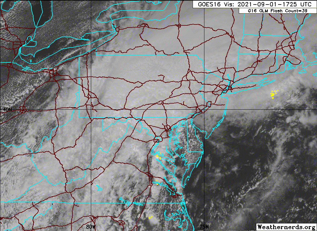
Tornado emergency in Trenton. Heavy damage from a violent tornado on the ground.
https://twitter.com/ywnreporter/status/ ... 51265?s=21
https://twitter.com/ywnreporter/status/ ... 51265?s=21
0 likes
Biologist by training, weather enthusiast for life.
-
ElectricStorm

- Category 5
- Posts: 5148
- Age: 25
- Joined: Tue Aug 13, 2019 11:23 pm
- Location: Norman, OK
Re: ATL: IDA - Post-Tropical - Discussion
Tornado emergency for Trenton, NJ. Wow
0 likes
B.S Meteorology, University of Oklahoma '25
Please refer to the NHC, NWS, or SPC for official information.
Please refer to the NHC, NWS, or SPC for official information.
Who is online
Users browsing this forum: No registered users and 18 guests