Tropical Wave off the Coast of Africa (Is Invest 90L)

This is the general tropical discussion area. Anyone can take their shot at predicting a storms path.

Moderator: S2k Moderators

Forum rules

The posts in this forum are NOT official forecasts and should not be used as such. They are just the opinion of the poster and may or may not be backed by sound meteorological data. They are NOT endorsed by any professional institution or STORM2K. For official information, please refer to products from the National Hurricane Center and National Weather Service.

Help Support Storm2K
Message
Author
User avatar
cycloneye
Admin
Admin
Posts: 145299
Age: 68
Joined: Thu Oct 10, 2002 10:54 am
Location: San Juan, Puerto Rico

Tropical Wave off the Coast of Africa (Is Invest 90L)

#1 Postby cycloneye » Fri Aug 27, 2021 12:36 pm

The models like this wave but let's see in reality how things evolve down the road.

Another tropical wave is expected to emerge off of the west African
coast by the middle of next week. Afterwards, environmental
conditions appear marginally conducive for gradual development
toward the end of next week as the system moves west-northwestward
to northwestward at 10 to 15 mph.
* Formation chance through 48 hours...low...near 0 percent.
* Formation chance through 5 days...low...20 percent.


Image
2 likes   
Visit the Caribbean-Central America Weather Thread where you can find at first post web cams,radars
and observations from Caribbean basin members Click Here

User avatar
aspen
Category 5
Category 5
Posts: 8818
Joined: Sat Oct 12, 2019 7:10 pm
Location: Connecticut, USA

Re: Tropical Wave to emerge from West Africa next week

#2 Postby aspen » Fri Aug 27, 2021 12:59 pm

Unless they give this an invest tag before it’s over water, this is easily gonna be one of the longest pre-invest threads ever.

The low latitude will help future 90L out a lot by having it over ~28C water for its earliest few days, and out of the way of any SAL that might be present. This has a good shot of becoming a MDR major before recurving…assuming it actually does recurve.
4 likes   
Irene '11 Sandy '12 Hermine '16 5/15/2018 Derecho Fay '20 Isaias '20 Elsa '21 Henri '21 Ida '21

I am only a meteorology enthusiast who knows a decent amount about tropical cyclones. Look to the professional mets, the NHC, or your local weather office for the best information.

User avatar
cycloneye
Admin
Admin
Posts: 145299
Age: 68
Joined: Thu Oct 10, 2002 10:54 am
Location: San Juan, Puerto Rico

Re: Tropical Wave to emerge from West Africa next week

#3 Postby cycloneye » Fri Aug 27, 2021 2:02 pm

12z Euro a little more west but goes NW eventually.

Image
1 likes   
Visit the Caribbean-Central America Weather Thread where you can find at first post web cams,radars
and observations from Caribbean basin members Click Here

User avatar
gatorcane
S2K Supporter
S2K Supporter
Posts: 23691
Age: 47
Joined: Sun Mar 13, 2005 3:54 pm
Location: Boca Raton, FL

Re: Tropical Wave to emerge from West Africa next week

#4 Postby gatorcane » Fri Aug 27, 2021 5:40 pm

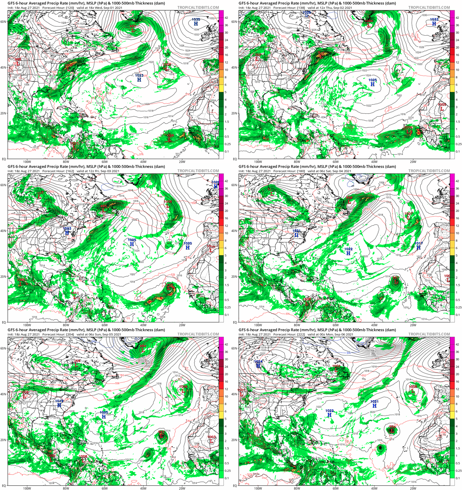
18Z GFS with a quick turn to the north:

Image
0 likes   

User avatar
aspen
Category 5
Category 5
Posts: 8818
Joined: Sat Oct 12, 2019 7:10 pm
Location: Connecticut, USA

Re: Tropical Wave to emerge from West Africa next week

#5 Postby aspen » Fri Aug 27, 2021 5:56 pm

gatorcane wrote:18Z GFS with a quick turn to the north:

https://i.postimg.cc/6p3YGjVy/gfs-mslp-pcpn-atl-fh120-222.gif

Keep in mind that the GFS usually underestimates ridges, while the Euro overestimates them. A recurve around 40-50W seems more likely than 25-30W. It may also be overestimating how long 98L’s remnants will be around and how much they’ll weaken the ridge.
1 likes   
Irene '11 Sandy '12 Hermine '16 5/15/2018 Derecho Fay '20 Isaias '20 Elsa '21 Henri '21 Ida '21

I am only a meteorology enthusiast who knows a decent amount about tropical cyclones. Look to the professional mets, the NHC, or your local weather office for the best information.

AlphaToOmega
Category 5
Category 5
Posts: 1448
Joined: Sat Jun 26, 2021 10:51 am
Location: Somewhere in Massachusetts

Re: Tropical Wave to emerge from West Africa next week

#6 Postby AlphaToOmega » Fri Aug 27, 2021 6:39 pm

Another tropical wave is expected to emerge off of the west African
coast by the middle of next week. Afterwards, environmental
conditions appear marginally conducive for gradual development
toward the end of next week as the system moves west-northwestward
to northwestward at 10 to 15 mph.
* Formation chance through 48 hours...low...near 0 percent.
* Formation chance through 5 days...low...30 percent.
0 likes   

User avatar
ConvergenceZone
Category 5
Category 5
Posts: 5194
Joined: Fri Jul 29, 2005 1:40 am
Location: Northern California

Re: Tropical Wave to emerge from West Africa next week

#7 Postby ConvergenceZone » Fri Aug 27, 2021 11:39 pm

thank goodness models are making this a fish storm(as was expected)....After IDA we will need a long break...........
0 likes   

AlphaToOmega
Category 5
Category 5
Posts: 1448
Joined: Sat Jun 26, 2021 10:51 am
Location: Somewhere in Massachusetts

Re: Tropical Wave to emerge from West Africa next week

#8 Postby AlphaToOmega » Sat Aug 28, 2021 6:27 am

A tropical wave is expected to emerge off the coast of west Africa
by the middle of next week. Thereafter, environmental conditions
appear somewhat conducive for gradual development toward the end of
next week as the system moves west-northwestward to northwestward at
10 to 15 mph.
* Formation chance through 48 hours...low...near 0 percent.
* Formation chance through 5 days...medium...50 percent.
0 likes   

User avatar
cycloneye
Admin
Admin
Posts: 145299
Age: 68
Joined: Thu Oct 10, 2002 10:54 am
Location: San Juan, Puerto Rico

Re: Tropical Wave to emerge from West Africa next week

#9 Postby cycloneye » Sat Aug 28, 2021 1:25 pm

A tropical wave is expected to emerge off the coast of west Africa
by the middle of next week. Thereafter, environmental conditions
appear somewhat conducive for gradual development toward the end of
next week as the system moves west-northwestward to northwestward at
10 to 15 mph.
* Formation chance through 48 hours...low...near 0 percent.
* Formation chance through 5 days...medium...60 percent.
0 likes   
Visit the Caribbean-Central America Weather Thread where you can find at first post web cams,radars
and observations from Caribbean basin members Click Here

User avatar
Blown Away
S2K Supporter
S2K Supporter
Posts: 10145
Joined: Wed May 26, 2004 6:17 am

Re: Tropical Wave to emerge from West Africa next week

#10 Postby Blown Away » Sat Aug 28, 2021 1:44 pm

97L, TD10, and this TW in a big Central Atlantic recurve loop.
0 likes   
Hurricane Eye Experience: David 79, Irene 99, Frances 04, Jeanne 04, Wilma 05... EYE COMING MY WAY IN 2024…
Hurricane Brush Experience: Andrew 92, Erin 95, Floyd 99, Matthew 16, Irma 17, Ian 22, Nicole 22…

User avatar
aspen
Category 5
Category 5
Posts: 8818
Joined: Sat Oct 12, 2019 7:10 pm
Location: Connecticut, USA

Re: Tropical Wave to emerge from West Africa next week

#11 Postby aspen » Sat Aug 28, 2021 3:10 pm

I hope this follows the Euro’s track: staying around 15N or lower until 40-45W before recurving. It’ll be able to rack up a ton of ACE and have the opportunity to become a major without threatening land. The GFS’s solution of a recurve the moment it exists Africa seems very unrealistic, and we’ve seen it bust with early recurves with TD10.
0 likes   
Irene '11 Sandy '12 Hermine '16 5/15/2018 Derecho Fay '20 Isaias '20 Elsa '21 Henri '21 Ida '21

I am only a meteorology enthusiast who knows a decent amount about tropical cyclones. Look to the professional mets, the NHC, or your local weather office for the best information.

Shell Mound
Category 5
Category 5
Posts: 2434
Age: 32
Joined: Thu Sep 07, 2017 3:39 pm
Location: St. Petersburg, FL → Scandinavia

Re: Tropical Wave to emerge from West Africa next week

#12 Postby Shell Mound » Sat Aug 28, 2021 3:48 pm

Blown Away wrote:97L, TD10, and this TW in a big Central Atlantic recurve loop.

Didn't you once suggest that the models were wrong about an early OTS path? :wink:
0 likes   
CVW / MiamiensisWx / Shell Mound
The posts in this forum are NOT official forecasts and should not be used as such. They are just the opinion of the poster and may or may not be backed by sound meteorological data. They are NOT endorsed by any professional institution or STORM2K. For official information, please refer to products from the NHC and NWS.

User avatar
Blown Away
S2K Supporter
S2K Supporter
Posts: 10145
Joined: Wed May 26, 2004 6:17 am

Re: Tropical Wave to emerge from West Africa next week

#13 Postby Blown Away » Sat Aug 28, 2021 6:00 pm

Shell Mound wrote:
Blown Away wrote:97L, TD10, and this TW in a big Central Atlantic recurve loop.

Didn't you once suggest that the models were wrong about an early OTS path? :wink:


Lol, maybe 4 days ago, the current globals so consistent with a early recurve and it seems likely b/c 97L & TD10 drifting around in the Central Atlantic not allowing HP to build. If this current TW stays weak/shallow up to at least 50W then it becomes a threat to W basin.
1 likes   
Hurricane Eye Experience: David 79, Irene 99, Frances 04, Jeanne 04, Wilma 05... EYE COMING MY WAY IN 2024…
Hurricane Brush Experience: Andrew 92, Erin 95, Floyd 99, Matthew 16, Irma 17, Ian 22, Nicole 22…

User avatar
cycloneye
Admin
Admin
Posts: 145299
Age: 68
Joined: Thu Oct 10, 2002 10:54 am
Location: San Juan, Puerto Rico

Re: Tropical Wave to emerge from West Africa next week

#14 Postby cycloneye » Sat Aug 28, 2021 6:24 pm

A tropical wave is expected to emerge off the coast of west Africa
by the middle of next week. Thereafter, environmental conditions
appear conducive for gradual development, and a tropical depression
is likely to form toward the end of next week as the system moves
west-northwestward to northwestward at 10 to 15 mph.
* Formation chance through 48 hours...low...near 0 percent.
* Formation chance through 5 days...high...70 percent.


Image
0 likes   
Visit the Caribbean-Central America Weather Thread where you can find at first post web cams,radars
and observations from Caribbean basin members Click Here

User avatar
Stormybajan
Category 1
Category 1
Posts: 448
Joined: Thu May 20, 2021 3:21 pm
Location: Windward Islands

Re: Tropical Wave to emerge from West Africa next week

#15 Postby Stormybajan » Sat Aug 28, 2021 6:26 pm

cycloneye wrote:
A tropical wave is expected to emerge off the coast of west Africa
by the middle of next week. Thereafter, environmental conditions
appear conducive for gradual development, and a tropical depression
is likely to form toward the end of next week as the system moves
west-northwestward to northwestward at 10 to 15 mph.
* Formation chance through 48 hours...low...near 0 percent.
* Formation chance through 5 days...high...70 percent.


https://i.imgur.com/wcpK5py.png

Code red for a wave that hasnt even moved off Africa :eek: , add this to the collection
6 likes   
Sad West Indies and Manchester United fan ⚽️

User avatar
cycloneye
Admin
Admin
Posts: 145299
Age: 68
Joined: Thu Oct 10, 2002 10:54 am
Location: San Juan, Puerto Rico

Re: Tropical Wave to emerge from West Africa next week

#16 Postby cycloneye » Sun Aug 29, 2021 6:57 am

A tropical wave is expected to emerge off the coast of west Africa
by Tuesday. Environmental conditions appear conducive for
development once the wave moves offshore, and a tropical depression
is likely to form toward the end of the week while the system moves
west-northwestward at 10 to 15 mph over the eastern tropical
Atlantic.
* Formation chance through 48 hours...low...20 percent.
* Formation chance through 5 days...high...80 percent.
0 likes   
Visit the Caribbean-Central America Weather Thread where you can find at first post web cams,radars
and observations from Caribbean basin members Click Here

User avatar
toad strangler
S2K Supporter
S2K Supporter
Posts: 4543
Joined: Sun Jul 28, 2013 3:09 pm
Location: Earth
Contact:

Re: Tropical Wave to emerge from West Africa next week

#17 Postby toad strangler » Sun Aug 29, 2021 7:09 am

Shell Mound wrote:
Blown Away wrote:97L, TD10, and this TW in a big Central Atlantic recurve loop.

Didn't you once suggest that the models were wrong about an early OTS path? :wink:


omg if trolling like that was allowed there would be a separate forum for your gaffes SM lol
3 likes   

User avatar
aspen
Category 5
Category 5
Posts: 8818
Joined: Sat Oct 12, 2019 7:10 pm
Location: Connecticut, USA

Re: Tropical Wave to emerge from West Africa on Tuesday

#18 Postby aspen » Sun Aug 29, 2021 10:53 am

All models are showing TD10/Kate creating a nice big gap in the ridge at around 50W which this storm (future Larry) gets pulled up into. Unless another ridge builds back in to block it, Larry will probably be a safe, high-ACE recurve.
0 likes   
Irene '11 Sandy '12 Hermine '16 5/15/2018 Derecho Fay '20 Isaias '20 Elsa '21 Henri '21 Ida '21

I am only a meteorology enthusiast who knows a decent amount about tropical cyclones. Look to the professional mets, the NHC, or your local weather office for the best information.

User avatar
cycloneye
Admin
Admin
Posts: 145299
Age: 68
Joined: Thu Oct 10, 2002 10:54 am
Location: San Juan, Puerto Rico

Re: Tropical Wave to emerge from West Africa on Tuesday

#19 Postby cycloneye » Sun Aug 29, 2021 12:40 pm

A tropical wave is expected to emerge off the west coast of Africa
by Monday night. Environmental conditions appear conducive for the
development of a low pressure area once the wave moves offshore,
and a tropical depression is likely to form by the middle or
latter part of the week while the system moves west-northwestward
at 10 to 15 mph over the eastern tropical Atlantic.
* Formation chance through 48 hours...low...30 percent.
* Formation chance through 5 days...high...80 percent.
0 likes   
Visit the Caribbean-Central America Weather Thread where you can find at first post web cams,radars
and observations from Caribbean basin members Click Here

User avatar
cycloneye
Admin
Admin
Posts: 145299
Age: 68
Joined: Thu Oct 10, 2002 10:54 am
Location: San Juan, Puerto Rico

Re: Tropical Wave to emerge from West Africa on Monday night

#20 Postby cycloneye » Sun Aug 29, 2021 1:30 pm

Invest 90L coming soon.

GENESIS027, AL, L, , , , , 79, 2021, DB, O, 2021082900, 9999999999, , 027, , , , GENESIS, , AL792021


https://ftp.nhc.noaa.gov/atcf/index/AL_storms.txt.nhc
4 likes   
Visit the Caribbean-Central America Weather Thread where you can find at first post web cams,radars
and observations from Caribbean basin members Click Here


Return to “Talkin' Tropics”

Who is online

Users browsing this forum: Ulf and 27 guests