
ATL: IDA - Remnants - Discussion
Moderator: S2k Moderators
-
Iceresistance

- Category 5

- Posts: 9602
- Age: 22
- Joined: Sat Oct 10, 2020 9:45 am
- Location: Tecumseh, OK/Norman, OK
Re: ATL: IDA - Hurricane - Discussion
AF305 may be higher up, but it has picked up a sharp pressure difference from the NW . . .
2 likes
Bill 2015 & Beta 2020
Winter 2020-2021
All observations are in Tecumseh, OK unless otherwise noted.
Winter posts are focused mainly for Oklahoma & Texas.
Take any of my forecasts with a grain of salt, refer to the NWS, SPC, and NHC for official information
Never say Never with weather! Because ANYTHING is possible!
Winter 2020-2021
All observations are in Tecumseh, OK unless otherwise noted.
Winter posts are focused mainly for Oklahoma & Texas.
Take any of my forecasts with a grain of salt, refer to the NWS, SPC, and NHC for official information
Never say Never with weather! Because ANYTHING is possible!

Re: ATL: IDA - Hurricane - Discussion
AF plane just reached the center, looks like the pressure has fallen to 985 mb
0 likes
Igor 2010, Sandy 2012, Fay 2014, Gonzalo 2014, Joaquin 2015, Nicole 2016, Humberto 2019, Imelda 2025
I am only a tropical weather enthusiast. My predictions are not official and may or may not be backed by sound meteorological data. For official information, please refer to the NHC and NWS products.
I am only a tropical weather enthusiast. My predictions are not official and may or may not be backed by sound meteorological data. For official information, please refer to the NHC and NWS products.
-
HurricaneEnzo

- Category 2

- Posts: 744
- Joined: Wed Mar 14, 2018 12:18 pm
- Location: Newport, NC (Hurricane Alley)
Re: ATL: IDA - Hurricane - Discussion
Here we go. CDO becoming more symmetrical and trying to clear an eye on IR. I think Ida is about to take off.
https://www.tropicaltidbits.com/sat/sat ... product=ir
Sent from my SM-N986U1 using Tapatalk
https://www.tropicaltidbits.com/sat/sat ... product=ir
Sent from my SM-N986U1 using Tapatalk
1 likes
Bertha 96' - Fran 96' - Bonnie 98' - Dennis 99' - Floyd 99' - Isabel 03' - Alex 04' - Ophelia 05' - Irene 11' - Arthur 14' - Matthew 16' - Florence 18' - Dorian 19' - Isaias 20' (countless other tropical storms and Hurricane swipes)
I am not a Professional Met just an enthusiast. Get your weather forecasts from the Pros!
I am not a Professional Met just an enthusiast. Get your weather forecasts from the Pros!


Re: ATL: IDA - Hurricane - Discussion
ADT is now at 4.5, so 977 mb and 77 kt. Of course recon has the most accurate data, but the increase in ADT is a clear indicator of Ida's improving organization. I was a bit surprised that the pressure is 'only' 985 mb, but I think it should start falling further soon. We'll find out whether it's still holding steady in terms of pressure during the next pass. Btw, will there be continuous recon in Ida from now on until landfall or what is the recon plan for the coming 2 days?
0 likes

Re: ATL: IDA - Hurricane - Discussion
NHC forecasters seem all be thinking what we are... the structure is there, the winds and pressure will match soon
https://twitter.com/EricBlake12/status/1431579287702933506
https://twitter.com/EricBlake12/status/1431579287702933506
1 likes
Very useful information on the Dvorak Technique --
https://severe.worldweather.wmo.int/TCF ... kBeven.pdf
https://severe.worldweather.wmo.int/TCF ... kBeven.pdf
-
Iceresistance
- Category 5
- Posts: 9602
- Age: 22
- Joined: Sat Oct 10, 2020 9:45 am
- Location: Tecumseh, OK/Norman, OK
Re: ATL: IDA - Hurricane - Discussion
NOAA 3's Dropsonde in the eye might support 985 MB . . .

0 likes
Bill 2015 & Beta 2020
Winter 2020-2021
All observations are in Tecumseh, OK unless otherwise noted.
Winter posts are focused mainly for Oklahoma & Texas.
Take any of my forecasts with a grain of salt, refer to the NWS, SPC, and NHC for official information
Never say Never with weather! Because ANYTHING is possible!
Winter 2020-2021
All observations are in Tecumseh, OK unless otherwise noted.
Winter posts are focused mainly for Oklahoma & Texas.
Take any of my forecasts with a grain of salt, refer to the NWS, SPC, and NHC for official information
Never say Never with weather! Because ANYTHING is possible!
Re: ATL: IDA - Hurricane - Discussion
985 mb
0 likes
Very useful information on the Dvorak Technique --
https://severe.worldweather.wmo.int/TCF ... kBeven.pdf
https://severe.worldweather.wmo.int/TCF ... kBeven.pdf


Re: ATL: IDA - Hurricane - Discussion
Woke up to take a quick look at satelitte. IR and BD curve suggest to me that a pin point eye may now be developing. If so, get ready to watch Ida shed 20-30 mb's in the hours to come 
0 likes
Andy D
(For official information, please refer to the NHC and NWS products.)
(For official information, please refer to the NHC and NWS products.)
-
hohnywx
- Category 2
- Posts: 511
- Age: 35
- Joined: Sun Jul 19, 2009 8:34 pm
- Location: Hastings-on-Hudson, NY
Re: ATL: IDA - Hurricane - Discussion
Highteeld wrote:NHC forecasters seem all be thinking what we are... the structure is there, the winds and pressure will match soon
https://twitter.com/EricBlake12/status/1431579287702933506
That satellite image is something to behold
0 likes
-
Iceresistance
- Category 5
- Posts: 9602
- Age: 22
- Joined: Sat Oct 10, 2020 9:45 am
- Location: Tecumseh, OK/Norman, OK
Re: ATL: IDA - Hurricane - Discussion
Lightning has been detected in the NW Eyewall

5 likes
Bill 2015 & Beta 2020
Winter 2020-2021
All observations are in Tecumseh, OK unless otherwise noted.
Winter posts are focused mainly for Oklahoma & Texas.
Take any of my forecasts with a grain of salt, refer to the NWS, SPC, and NHC for official information
Never say Never with weather! Because ANYTHING is possible!
Winter 2020-2021
All observations are in Tecumseh, OK unless otherwise noted.
Winter posts are focused mainly for Oklahoma & Texas.
Take any of my forecasts with a grain of salt, refer to the NWS, SPC, and NHC for official information
Never say Never with weather! Because ANYTHING is possible!
-
dexterlabio
- Category 5
- Posts: 3513
- Joined: Sat Oct 24, 2009 11:50 pm
Re: ATL: IDA - Hurricane - Discussion
Iceresistance wrote:Lightning has been detected in the NW Eyewall
https://s9.gifyu.com/images/GOES16_1km_ir_202108281125_19.75_28.25_-92.25_-78.25_ir1_ltng16_hgwy_warn_latlon_weathernerds.png
Dvorak numbers will skyrocket in the next few hours, I feel.
0 likes
Personal Forecast Disclaimer:
The posts in this forum are NOT official forecast and should not be used as such. They are just the opinion of the poster and may or may not be backed by sound meteorological data. They are NOT endorsed by any professional institution or storm2k.org. For official information, please refer to the NHC and NWS products.
The posts in this forum are NOT official forecast and should not be used as such. They are just the opinion of the poster and may or may not be backed by sound meteorological data. They are NOT endorsed by any professional institution or storm2k.org. For official information, please refer to the NHC and NWS products.
-
Category5Kaiju

- Category 5
- Posts: 4341
- Joined: Thu Dec 24, 2020 12:45 pm
- Location: Seattle during the summer, Phoenix during the winter
Re: ATL: IDA - Hurricane - Discussion
Iceresistance wrote:Lightning has been detected in the NW Eyewall
https://s9.gifyu.com/images/GOES16_1km_ir_202108281125_19.75_28.25_-92.25_-78.25_ir1_ltng16_hgwy_warn_latlon_weathernerds.png
Well, well, here we go. Eye formation commences
0 likes
Unless explicitly stated, all information in my posts is based on my own opinions and observations. Tropical storms and hurricanes can be extremely dangerous. Refer to an accredited weather research agency or meteorologist if you need to make serious decisions regarding an approaching storm.
-
AlphaToOmega
- Category 5
- Posts: 1448
- Joined: Sat Jun 26, 2021 10:51 am
- Location: Somewhere in Massachusetts
Re: ATL: IDA - Hurricane - Discussion
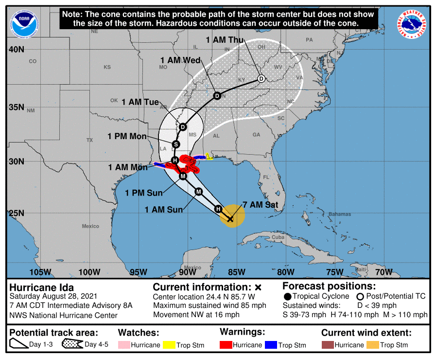
The intermediate advisory has not been published yet. It is interesting to see what the NHC thinks now.
0 likes
-
Sciencerocks
- Category 5
- Posts: 10186
- Age: 40
- Joined: Thu Jul 06, 2017 1:51 am

-
tropicwatch

- Category 5
- Posts: 3426
- Age: 62
- Joined: Sat Jun 02, 2007 10:01 am
- Location: The Villages, Florida
- Contact:
Re: ATL: IDA - Hurricane - Discussion
AlphaToOmega wrote:The intermediate advisory has not been published yet. It is interesting to see what the NHC thinks now.
Looks like wind field is expanding which could mean additional watches/warnings.
2 likes
Tropicwatch
Agnes 72', Eloise 75, Elena 85', Kate 85', Charley 86', Florence 88', Beryl 94', Dean 95', Erin 95', Opal 95', Earl 98', Georges 98', Ivan 2004', Arlene 2005', Dennis 2005', Ida 2009' Debby 2012' Irma 2017' Michael 2018'
Agnes 72', Eloise 75, Elena 85', Kate 85', Charley 86', Florence 88', Beryl 94', Dean 95', Erin 95', Opal 95', Earl 98', Georges 98', Ivan 2004', Arlene 2005', Dennis 2005', Ida 2009' Debby 2012' Irma 2017' Michael 2018'
Re: ATL: IDA - Hurricane - Discussion
85mph/985mb for the intermediate
Last edited by Owasso on Sat Aug 28, 2021 6:54 am, edited 2 times in total.
1 likes
-
beoumont

- Category 1

- Posts: 473
- Joined: Sun Jul 10, 2011 4:13 pm
- Location: East Central Florida
- Contact:
Re: ATL: IDA - Hurricane - Discussion
chaser1 wrote:Woke up to take a quick look at satelitte. IR and BD curve suggest to me that a pin point eye may now be developing. If so, get ready to watch Ida shed 20-30 mb's in the hours to come
From the 11:42 z, Vortex Message:
A. Time of Center Fix: 28th day of the month at 11:17:30Z
B. Center Fix Coordinates: 24.36N 85.57W
B. Center Fix Location: 220 statute miles (355 km) to the WNW (293°) from Havana, Cuba.
C. Minimum Height at Standard Level: 2,975m (9,760ft) at 700mb
D. Minimum Sea Level Pressure: 987mb (29.15 inHg)
E. Dropsonde Surface Wind at Center: From 50° at 11kts (From the NE at 13mph)
F. Eye Character: Open in the northwest
G. Eye Shape: Elliptical (oval shaped)
G. Orientation of Major Axis in Elliptical Eye: 30° to 210° (NNE to SSW)
G. Length of Major Axis in Elliptical Eye: 36 nautical miles (41 statute miles)
G. Length of Minor Axis in Elliptical Eye: 16 nautical miles (18 statute miles)
Last edited by beoumont on Sat Aug 28, 2021 6:54 am, edited 1 time in total.
0 likes
List of 79 tropical cyclones intercepted by Richard Horodner:
http://www.canebeard.com/page/page/572246.htm
http://www.canebeard.com/page/page/572246.htm

Re: ATL: IDA - Hurricane - Discussion
very impressive looking this morning, seems like recon got there in good timing, are they on 3 hour fixes yet?
1 likes
Once I see the REDS and GREENS Converge on a Base Velocity. ... I'm There!!
This is NOT an Official Forecast....Just my Opinion. For official information, please refer to the NHC and NWS products.
HIGHLIGHTS : '13 El Reno Tornado : 2013 Storm Chaser Tour, Joaquin; SC flood event, Matthew '16, Lowcountry Snow storm Jan '18
This is NOT an Official Forecast....Just my Opinion. For official information, please refer to the NHC and NWS products.
HIGHLIGHTS : '13 El Reno Tornado : 2013 Storm Chaser Tour, Joaquin; SC flood event, Matthew '16, Lowcountry Snow storm Jan '18
Who is online
Users browsing this forum: No registered users and 14 guests