ATL: IDA - Remnants - Discussion
Moderator: S2k Moderators
Re: ATL: IDA - Hurricane - Discussion
I’m not sure why everyone is suddenly saying Cat 3 instead of Cat 4 because it has slightly degraded for the moment. This thing could go from Cat 1 to Cat 4 in 12-18 hours if it wanted to. Where is all the talk about conditions being nearly perfect that was occurring this afternoon?
15 likes
-
InfernoFlameCat

- Category 5

- Posts: 2127
- Age: 22
- Joined: Mon Dec 14, 2020 10:52 am
- Location: Buford, GA
Re: ATL: IDA - Hurricane - Discussion
This still looks like a CAT 4 landfall right now. in fact, Ida STILL outperformed most models crossing Cuba.
1 likes
I am by no means a professional. DO NOT look at my forecasts for official information or make decisions based on what I post.
Goal: to become a registered expert over tropical and subtropical cyclones.
Goal: to become a registered expert over tropical and subtropical cyclones.
-
jasons2k

- Storm2k Executive

- Posts: 8290
- Age: 52
- Joined: Wed Jul 06, 2005 12:32 pm
- Location: The Woodlands, TX
Re: ATL: IDA - Hurricane - Discussion
Not sure what happened to my post about 30 min ago. Anyway based on what I see on satellite, the core is relatively small and in-tact, and primed for rapid intensification. This is nothing like Ike or Gustav which never fully got their acts together again. I’m afraid Ida is off to the races now.
13 likes
-
PavelGaborik
- Tropical Depression

- Posts: 81
- Joined: Thu Oct 06, 2016 11:13 pm
Re: ATL: IDA - Hurricane - Discussion
wx98 wrote:I’m not sure why everyone is suddenly saying Cat 3 instead of Cat 4 because it has slightly degraded for the moment. This thing could go from Cat 1 to Cat 4 in 12-18 hours if it wanted to. Where is all the talk about conditions being nearly perfect that was occurring this afternoon?
People are too reactive. It's certainly a small positive that the core was beaten up, but any discussions about this knocking it down a category in the long run right now is most certainly premature.
9 likes
-
skyline385

- Category 5
- Posts: 2728
- Age: 35
- Joined: Wed Aug 26, 2020 11:15 pm
- Location: Houston TX

-
ConvergenceZone
.gif)
- Category 5
- Posts: 5241
- Joined: Fri Jul 29, 2005 1:40 am
- Location: Northern California
Re: ATL: IDA - Hurricane - Discussion
wx98 wrote:I’m not sure why everyone is suddenly saying Cat 3 instead of Cat 4 because it has slightly degraded for the moment. This thing could go from Cat 1 to Cat 4 in 12-18 hours if it wanted to. Where is all the talk about conditions being nearly perfect that was occurring this afternoon?
Because just like some people who say that this going to a Cat 5, there are some of us who are looking for any ray of hope that we can find that it won't make it that high, such as disrupted core etc, even if it only delays strengthening for 2 hours, it's still something.....
3 likes
-
cheezyWXguy

- Category 5
- Posts: 6282
- Joined: Mon Feb 13, 2006 12:29 am
- Location: Dallas, TX
Re: ATL: IDA - Hurricane - Discussion
These blowups were seeing are likely the first steps toward establishing dual channel outflow. Now that the dominant inflow band south of the center is offshore, convection is exploding and wrapping up the southeast side, while the western blowup establishes the northern band. Once each of these gets to the core, the rate of intensification will likely increase.
2 likes
-
Hurrilurker

- Category 2

- Posts: 738
- Joined: Mon Jun 09, 2003 3:32 pm
- Location: San Francisco, CA
Re: ATL: IDA - Hurricane - Discussion
Cloud tops are cooling, CDO coming back, convection beginning to wrap back in. Good chance it's a solid Cat 2 by tomorrow morning IMO.
1 likes
Re: ATL: IDA - Hurricane - Discussion
Satellite imagery when a storm is overland can sometimes be deceiving, as frictional convergence would help the storm maintain its convection.
It’s quite common for convection to weaken a bit once the storm moves back over water, as it is no longer aided by frictional convergence. However, Ida is able to fire up convection once it moves back over water (especially the northwestern quadrant), which is a sign that land interaction is less of an impact as normal.
It’s also a common pattern for a storm emerging from land to first develop a banding eye (the dry slot currently evident in satellite imagery is likely one as well). As convection gradually wraps around the center and symmetrises, the storm’s core would contract, which would allow for quicker intensification. Zeta last year followed a similar pattern last year after it emerges from the Yucatan.
How much Ida can intensify depends on how fast it can reorganise its core before reaching the warm eddy in the Gulf. The current trend is similar to what has been shown in subjective forecast and model stimulation so far.
10 likes
Personal Forecast Disclaimer:
The posts in this forum are NOT official forecast and should not be used as such. They are just the opinion of the poster and may or may not be backed by sound meteorological data. They are NOT endorsed by any professional institution or storm2k.org. For official information, please refer to RSMC and NWS products.
The posts in this forum are NOT official forecast and should not be used as such. They are just the opinion of the poster and may or may not be backed by sound meteorological data. They are NOT endorsed by any professional institution or storm2k.org. For official information, please refer to RSMC and NWS products.
-
skyline385
- Category 5
- Posts: 2728
- Age: 35
- Joined: Wed Aug 26, 2020 11:15 pm
- Location: Houston TX
Re: ATL: IDA - Hurricane - Discussion
Looks like 0Z HWRF got the structure right, spends about 6 hours consolidating outside Cuba then blows up dropping from 976mb to 959mb in 6 hours...
1 likes
-
galaxy401

- Category 5
- Posts: 2446
- Age: 30
- Joined: Sat Aug 25, 2012 9:04 pm
- Location: Casa Grande, Arizona
Re: ATL: IDA - Hurricane - Discussion
Going to be very interesting to see what kind of storm we'll wake up to in the morning. It will be very stressful.
0 likes
Got my eyes on moving right into Hurricane Alley: Florida.
-
Sciencerocks
- Category 5
- Posts: 10186
- Age: 40
- Joined: Thu Jul 06, 2017 1:51 am

-
CrazyC83
- Professional-Met

- Posts: 34315
- Joined: Tue Mar 07, 2006 11:57 pm
- Location: Deep South, for the first time!
Re: ATL: IDA - Hurricane - Discussion
Looking back to the 5 pm advisory, it appears the track will verify almost perfectly (should be at 23.4N 84.7W - a touch slower but same trajectory). The intensity will be a low miss (forecast 85 kt - actual 70 kt) but there is no reason why it cannot make up that intensity with an even faster intensification in the Loop Current. It still has about 24 hours in it.
1 likes
-
Keldeo1997
- Category 2
- Posts: 688
- Joined: Fri Oct 11, 2019 11:35 pm
Re: ATL: IDA - Hurricane - Discussion

Eyewall is back. Open to the South.

Temps going up as well
0 likes
-
Shell Mound
- Category 5
- Posts: 2432
- Age: 33
- Joined: Thu Sep 07, 2017 3:39 pm
- Location: St. Petersburg, FL → Scandinavia
Re: ATL: IDA - Hurricane - Discussion
Some mixed signals for NOLA: according to models lower-level steering would favour landfall farther east, so a weaker Ida would actually make LF closer to NOLA than a stronger storm. A weaker Ida would also likely be more compact than a stronger Ida, thus lessening the risk of surge somewhat. The 00Z guidance has trended toward a weaker Ida at LF and on balance has shifted notably closer to NOLA. Given current organisational trends, Ida looks to be suffering from some southerly mid-level shear, in addition to the effects of interaction with Cuba. Given that its forward speed has not changed significantly, Ida would need to organise rapidly in order to match the most aggressive guidance, especially earlier runs. At this point I think some of the most extreme solutions are becoming less likely, though a major hurricane should still be anticipated. A Category 4 rather than a Category 5 at its peak seems to be more plausible now, however.
1 likes
CVW / MiamiensisWx / Shell Mound
The posts in this forum are NOT official forecasts and should not be used as such. They are just the opinion of the poster and may or may not be backed by sound meteorological data. They are NOT endorsed by any professional institution or STORM2K. For official information, please refer to products from the NHC and NWS.
-
USTropics
- Professional-Met
- Posts: 2739
- Joined: Sun Aug 12, 2007 3:45 am
- Location: Florida State University
Re: ATL: IDA - Hurricane - Discussion
Satellite presentation can be a bit deceiving on what is actually occurring at the low-mid levels of Ida. The good news first: land interaction with Cuba definitely put a temporary pause on intensification. This continues to put a cap on max inflow potential until Ida sufficiently pulls away from the Cuban coastline, which has resulted in a decrease in cloud top temperatures. Disruption of inflow also created a bit of a dry slot on the eastern side of the storm, but has since filled in over the past few frames:
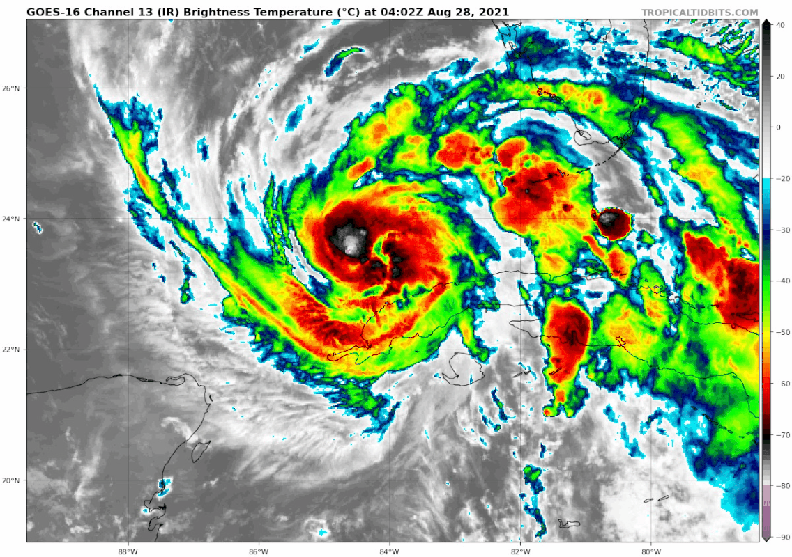
Now for some of the bad news: radar presentation from Cuba shows land interaction did not significantly disrupt the low-mid level core. The core is circled in pink below, and from the loop we can see evident banding in the western and northeastern quadrant beginning to rotate to the south and west, respectively. If this banding continues to rotate around and closes off, forming an eyewall, Ida will undergo significant intensification during DMAX.


Now for some of the bad news: radar presentation from Cuba shows land interaction did not significantly disrupt the low-mid level core. The core is circled in pink below, and from the loop we can see evident banding in the western and northeastern quadrant beginning to rotate to the south and west, respectively. If this banding continues to rotate around and closes off, forming an eyewall, Ida will undergo significant intensification during DMAX.
7 likes
-
FLpanhandle91

- Category 5
- Posts: 1039
- Age: 34
- Joined: Mon Sep 13, 2010 3:50 pm
- Location: Fort Walton Beach, FL
-
CrazyC83
- Professional-Met
- Posts: 34315
- Joined: Tue Mar 07, 2006 11:57 pm
- Location: Deep South, for the first time!
Re: ATL: IDA - Hurricane - Discussion
Ida also moved more west than north in the last few hours according to Recon. That pretty much corrected any movements near Cuba.
I agree that the ceiling remains very high. A delayed intensification also means it is more likely to strengthen right up to landfall, rather than hit an ERC or something to knock it down. That is what happened with Michael.
I agree that the ceiling remains very high. A delayed intensification also means it is more likely to strengthen right up to landfall, rather than hit an ERC or something to knock it down. That is what happened with Michael.
8 likes
-
CrazyC83
- Professional-Met
- Posts: 34315
- Joined: Tue Mar 07, 2006 11:57 pm
- Location: Deep South, for the first time!
Re: ATL: IDA - Hurricane - Discussion
Dropsonde suggests 986 mb. The previous pass likely missed the true center.
1 likes
-
Stormgodess

- Category 1

- Posts: 316
- Joined: Mon Sep 14, 2020 1:31 am
Re: ATL: IDA - Hurricane - Discussion
wx98 wrote:I’m not sure why everyone is suddenly saying Cat 3 instead of Cat 4 because it has slightly degraded for the moment. This thing could go from Cat 1 to Cat 4 in 12-18 hours if it wanted to. Where is all the talk about conditions being nearly perfect that was occurring this afternoon?
Personally, I think its to avoid panic. It was nuts in Louisiana today, no gas, runs on suppiles.
I dont agree with it.... And a bunch of ranting that I just deleted before posting
2 likes
Who is online
Users browsing this forum: No registered users and 6 guests