99L INVEST 210826 1200 16.4N 79.0W ATL 30 1005

Moderator: S2k Moderators


jaxfladude wrote:When Will We Get Some Solid Idea Of Where 99L/Ida Will Go? Tired of the waiting game so to speak...

18z set of models or too soon for those models? 0z set of models should have the abovementioned data?xironman wrote:jaxfladude wrote:When Will We Get Some Solid Idea Of Where 99L/Ida Will Go? Tired of the waiting game so to speak...
Once the models get the data from this flightFLIGHT TWO - NOAA 49
A. 27/1200Z
B. NOAA9 O209A CYCLONE
C. 27/0530Z
D. NA
E. NA
F. 41,000 TO 45,000 FT
Kohlecane wrote:with that RGB and noted W movement I would say its closer to 17N(+/-) and 77.5W(+/-) just my view
EDIT: submit and see above postI was not that far off

BobHarlem wrote:Is it just me or is the Upper Low/TUTT over Florida tugging 99L to the north?
BobHarlem wrote:Is it just me or is the Upper Low/TUTT over Florida tugging 99L to the north? https://www.tropicaltidbits.com/sat/sat ... uct=wv-mid
BobHarlem wrote:Is it just me or is the Upper Low/TUTT over Florida tugging 99L to the north? https://www.tropicaltidbits.com/sat/sat ... uct=wv-mid
Jagno wrote:As a resident still living in a camper in my driveway I appreciate the positive but in fact we are so very far from ready and nwhere near being recovered. We've been thrilled to finally have a few more restaurants reopen but it's still far from normal. Myself, along with one of my daughter in laws spent hours searching and calling around for a nice RV park out of harms way only to find most were already booked. We finally found a nice campground but get this. You lose your money if the reservation is not cancelled within 8 days so they've got every single evacuee like me doling out several hundred dollars that you may or may not lose. State parks are still mostly closed with Covid restrictions. PTSD is very real and people are stressing big time.
Shell Mound wrote:Structurally this is still rather disorganised. While low-level turning is evident, 99L’s western hemisphere (half) is largely devoid of convection, owing to strong mid-level shear. Certainly, the mid-level circulation is well defined, and PWATs are high, but the TUTT (PVS) is clearly preventing consolidation as of now. The TUTT is weakening and retrograding, but doing so very slowly at this time. Also, while the past several runs of the GFS have adjusted themselves to account for 99L’s short-term organisation (and resultant, convectively induced ULAC), the runs have also trended toward a stronger PVS over peninsular FL and the Yucatán Channel. This effectively offsets 99L’s better-than-expected short-term, mid-level organisation and implies that 99L will likely not strengthen significantly prior to reaching western Cuba.

Jr0d wrote:BobHarlem wrote:Is it just me or is the Upper Low/TUTT over Florida tugging 99L to the north? https://www.tropicaltidbits.com/sat/sat ... uct=wv-mid
Sure looks like it. If I recall correctly, the ULL is forecast to move WSW enabling more north movement in the short term for soon to be Julian.
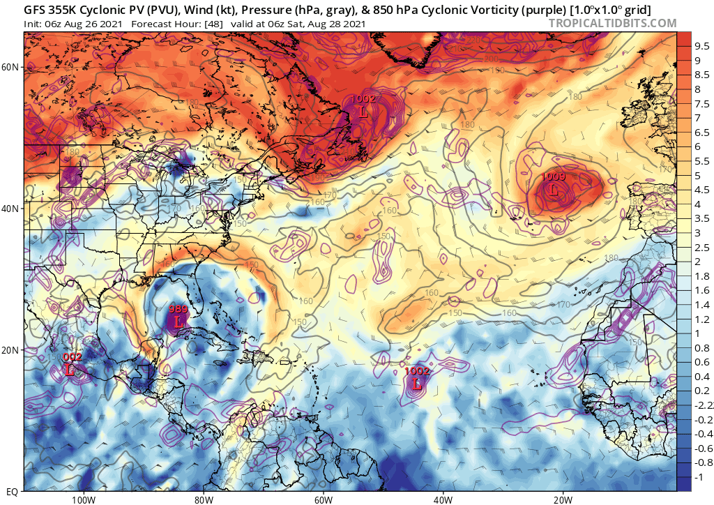
Shell Mound wrote:GCANE wrote:Ouch!!
Right in the middle of a 355K PV Ring as it enters the GoM
https://i.postimg.cc/XJvScVMK/gfs-pv355-K-atl-9.png
Unless 99L is somehow sufficiently strong, the PVS just to its west would still induce westerly shear, thus limiting intensification over the Gulf. The PVS is attributable to downstream wave fluxes associated with TD Fourteen's convection over the EPAC near the west coast of Mexico. This PVS will play a major role in 99L's ultimate intensity. A stronger 99L prior to western Cuba would be better able to offset westerly shear from TD Fourteen.

Shell Mound wrote:Structurally this is still rather disorganised. While low-level turning is evident, 99L’s western hemisphere (half) is largely devoid of convection, owing to strong mid-level shear. Certainly, the mid-level circulation is well defined, and PWATs are high, but the TUTT (PVS) is clearly preventing consolidation as of now. The TUTT is weakening and retrograding, but doing so very slowly at this time. Also, while the past several runs of the GFS have adjusted themselves to account for 99L’s short-term organisation (and resultant, convectively induced ULAC), the runs have also trended toward a stronger PVS over peninsular FL and the Yucatán Channel. This effectively offsets 99L’s better-than-expected short-term, mid-level organisation and implies that 99L will likely not strengthen significantly prior to reaching western Cuba.


cycloneye wrote:12z Best Track:99L INVEST 210826 1200 16.4N 79.0W ATL 30 1005
https://i.imgur.com/aXlJyFV.png
ScottNAtlanta wrote:Shell Mound wrote:Structurally this is still rather disorganised. While low-level turning is evident, 99L’s western hemisphere (half) is largely devoid of convection, owing to strong mid-level shear. Certainly, the mid-level circulation is well defined, and PWATs are high, but the TUTT (PVS) is clearly preventing consolidation as of now. The TUTT is weakening and retrograding, but doing so very slowly at this time. Also, while the past several runs of the GFS have adjusted themselves to account for 99L’s short-term organisation (and resultant, convectively induced ULAC), the runs have also trended toward a stronger PVS over peninsular FL and the Yucatán Channel. This effectively offsets 99L’s better-than-expected short-term, mid-level organisation and implies that 99L will likely not strengthen significantly prior to reaching western Cuba.
There is little mid shear per Univ Wis. and it looks like it is right under an anticyclone. I see no degradation on the west side. This is right where the HWRF said it would be a couple of days ago. I even mentioned it then. Outflow is increasing SE and NW sides. This is probably a depression all ready if not a TS
ConvergenceZone wrote:Shell Mound wrote:GCANE wrote:Ouch!!
Right in the middle of a 355K PV Ring as it enters the GoM
https://i.postimg.cc/XJvScVMK/gfs-pv355-K-atl-9.png
Unless 99L is somehow sufficiently strong, the PVS just to its west would still induce westerly shear, thus limiting intensification over the Gulf. The PVS is attributable to downstream wave fluxes associated with TD Fourteen's convection over the EPAC near the west coast of Mexico. This PVS will play a major role in 99L's ultimate intensity. A stronger 99L prior to western Cuba would be better able to offset westerly shear from TD Fourteen.
True, but even if it ends up being just a Cat 1, it can still do quite a bit of damage, but yea I also noticed the landfall pressure doesn't seem near as low as it did with a few of the runs before, which is some good news anyway... Probably sensing more shear that you mentioned....
Users browsing this forum: No registered users and 9 guests


