Tropical Wave over the Central Caribbean (Is Invest 99L)

This is the general tropical discussion area. Anyone can take their shot at predicting a storms path.

Moderator: S2k Moderators

Forum rules

The posts in this forum are NOT official forecasts and should not be used as such. They are just the opinion of the poster and may or may not be backed by sound meteorological data. They are NOT endorsed by any professional institution or STORM2K. For official information, please refer to products from the National Hurricane Center and National Weather Service.

Help Support Storm2K
Message
Author
underthwx
Category 5
Category 5
Posts: 2360
Joined: Sat Jul 30, 2011 2:14 pm
Location: Brazoria County Texas

Re: Tropical Wave over the Eastern Caribbean

#81 Postby underthwx » Tue Aug 24, 2021 7:06 am

grapealcoholic wrote:
SoupBone wrote:
grapealcoholic wrote:It's worthless to even post deterministic runs this early, let alone talk about them busting lol


We're not talking about a 14+ day run fantasy land, we're talking 6 days from now. That's a small enough window to make these discussions legitimate.

Part of which includes resolving a monsoon trough


Meaning?...
0 likes   

User avatar
NDG
S2K Supporter
S2K Supporter
Posts: 15446
Joined: Sun Jul 09, 2006 10:14 pm
Location: Orlando, FL

Re: Tropical Wave over the Eastern Caribbean

#82 Postby NDG » Tue Aug 24, 2021 7:09 am

1 likes   

User avatar
NDG
S2K Supporter
S2K Supporter
Posts: 15446
Joined: Sun Jul 09, 2006 10:14 pm
Location: Orlando, FL

Re: Tropical Wave over the Eastern Caribbean

#83 Postby NDG » Tue Aug 24, 2021 7:22 am

Hammy wrote:Euro shows an open wave, so we have three completely different solutions--though worth noting the model had a tropical wave for Grace 72h before it was a hurricane.

https://i.imgur.com/FazWhVA.png


Don't forget the Euro Operational doesn't do too well with forecasting development and or strength of developing systems. One of many examples was Henri. Is better to look at its ensembles for potential developing systems.

Image
3 likes   

User avatar
Category5Kaiju
Category 5
Category 5
Posts: 4096
Joined: Thu Dec 24, 2020 12:45 pm
Location: Seattle

Re: Tropical Wave over the Eastern Caribbean

#84 Postby Category5Kaiju » Tue Aug 24, 2021 7:47 am

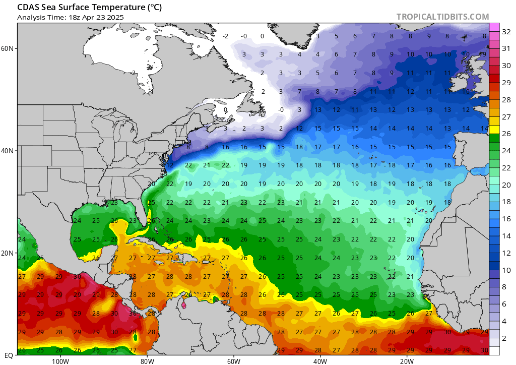
Image

Whatever exactly happens with this system in the Gulf, thermodynamics is extremely favorable for a potent storm (in fact, it looks like Grace did not really dent the BoC skin temp. as much), and if recent years serve as any indication, if shear and dry air cooperate, be careful.
6 likes   
Unless explicitly stated, all info in my posts is based on my own opinions and observations. Tropical storms and hurricanes can be extremely dangerous. Do not think you can beat Mother Nature. Refer to an accredited weather research agency or meteorologist if you need to make serious decisions regarding an approaching storm.

User avatar
wxman57
Moderator-Pro Met
Moderator-Pro Met
Posts: 22978
Age: 67
Joined: Sat Jun 21, 2003 8:06 pm
Location: Houston, TX (southwest)

Re: Tropical Wave over the Eastern Caribbean

#85 Postby wxman57 » Tue Aug 24, 2021 7:54 am

I think there's at least a 90% chance we'll have at least a TS in the southern Gulf by Sunday/Monday. Threat may be farther north than Grace. Definitely not ruling out Texas. Only real question is whether it will be Ida or Julian. System in the open Atlantic may develop first and head out to sea.

First day off in 2 weeks yesterday and I biked 30 miles for "rest". Today, I pressure wash the house for rest. Might be able to squeeze one more day off tomorrow before we start advisories on the Caribbean system. At least I'll be all rested up for this next long stretch.
19 likes   

User avatar
cheezyWXguy
Category 5
Category 5
Posts: 6108
Joined: Mon Feb 13, 2006 12:29 am
Location: Dallas, TX

Re: Tropical Wave over the Eastern Caribbean

#86 Postby cheezyWXguy » Tue Aug 24, 2021 7:57 am

NDG wrote:
Hammy wrote:Euro shows an open wave, so we have three completely different solutions--though worth noting the model had a tropical wave for Grace 72h before it was a hurricane.

https://i.imgur.com/FazWhVA.png


Don't forget the Euro Operational doesn't do too well with forecasting development and or strength of developing systems. One of many examples was Henri. Is better to look at its ensembles for potential developing systems.

https://i.imgur.com/Otrx2im.gif

Looks like about a 70-30 split between formation focusing on the cag (west) or the wave (east). If the wave serves as the focus for development, nearly all members go into Texas, and if it’s the cag, maybe 30-40% of those go north of the Mexico border. Taking those probabilities together gives us… roughly 50/50 odds? Yeah, that helps a lot… :lol:
0 likes   

User avatar
ROCK
Category 5
Category 5
Posts: 9484
Age: 54
Joined: Tue Aug 17, 2004 7:30 am
Location: Kemah, Texas

Re: Tropical Wave over the Eastern Caribbean

#87 Postby ROCK » Tue Aug 24, 2021 8:07 am

wxman57 wrote:I think there's at least a 90% chance we'll have at least a TS in the southern Gulf by Sunday/Monday. Threat may be farther north than Grace. Definitely not ruling out Texas. Only real question is whether it will be Ida or Julian. System in the open Atlantic may develop first and head out to sea.

First day off in 2 weeks yesterday and I biked 30 miles for "rest". Today, I pressure wash the house for rest. Might be able to squeeze one more day off tomorrow before we start advisories on the Caribbean system. At least I'll be all rested up for this next long stretch.


I agree..for starters. I think a hurricane thereafter is not out of the question. Now how strong it will be remains unknown.
0 likes   

User avatar
ROCK
Category 5
Category 5
Posts: 9484
Age: 54
Joined: Tue Aug 17, 2004 7:30 am
Location: Kemah, Texas

Re: Tropical Wave over the Eastern Caribbean

#88 Postby ROCK » Tue Aug 24, 2021 8:10 am

IcyTundra wrote:Euro doubles down on the Texas solution…. It will be interesting to see what the euro ensembles say but I’m not staying up for that


not going to stay up? Oh come on... :lol: some of us have been here since 2005. We always stay up for every run. :D
4 likes   

User avatar
NDG
S2K Supporter
S2K Supporter
Posts: 15446
Joined: Sun Jul 09, 2006 10:14 pm
Location: Orlando, FL

Re: Tropical Wave over the Eastern Caribbean

#89 Postby NDG » Tue Aug 24, 2021 8:26 am

cheezyWXguy wrote:
NDG wrote:
Hammy wrote:Euro shows an open wave, so we have three completely different solutions--though worth noting the model had a tropical wave for Grace 72h before it was a hurricane.

https://i.imgur.com/FazWhVA.png


Don't forget the Euro Operational doesn't do too well with forecasting development and or strength of developing systems. One of many examples was Henri. Is better to look at its ensembles for potential developing systems.

https://i.imgur.com/Otrx2im.gif

Looks like about a 70-30 split between formation focusing on the cag (west) or the wave (east). If the wave serves as the focus for development, nearly all members go into Texas, and if it’s the cag, maybe 30-40% of those go north of the Mexico border. Taking those probabilities together gives us… roughly 50/50 odds? Yeah, that helps a lot… :lol:


What I take out of it is that the Euro ensembles show a good chance for development vs the Opertional run showing an open wave in the southern GOM, where it happens and what track it takes that remains the uncertainty until we see exactly where it develops.
1 likes   

User avatar
Rgv20
S2K Supporter
S2K Supporter
Posts: 2466
Age: 38
Joined: Wed Jan 05, 2011 5:42 pm
Location: Edinburg/McAllen Tx

Re: Tropical Wave over the Eastern Caribbean

#90 Postby Rgv20 » Tue Aug 24, 2021 8:55 am

A lot of uncertainty with regards to track but models fairly confident on something developing in the Southern GOM late this weekend heading until early next week. Euro ensembles have a pretty wide spread with the possible track but it looks like the target area is between Tampico and Texas/LA border.
0 likes   
The following post is NOT an official forecast and should not be used as such. It is just the opinion of the poster and may or may not be backed by sound meteorological data. It is NOT endorsed by any professional institution including storm2k.org For Official Information please refer to the NHC and NWS products.

User avatar
lrak
S2K Supporter
S2K Supporter
Posts: 1770
Age: 58
Joined: Thu Jun 21, 2007 2:48 pm
Location: Corpus Christi, TX

Re: Tropical Wave over the Eastern Caribbean

#91 Postby lrak » Tue Aug 24, 2021 9:09 am

This is not the news I expected. I'm still hopeful for ONLY another surf event..ugh
1 likes   
AKA karl

Also
Personal Forecast Disclaimer:
My posts on this forum are NOT official forecast and should not be used as such. My posts are my basic observations and are definitely not backed by any "well some" meteorological knowledge. For official information, please refer to the NHC and NWS products.

IcyTundra
Category 5
Category 5
Posts: 1205
Joined: Mon Jun 07, 2021 9:32 pm
Location: Dickinson, Texas

Re: Tropical Wave over the Eastern Caribbean

#92 Postby IcyTundra » Tue Aug 24, 2021 9:10 am

NDG wrote:
cheezyWXguy wrote:
NDG wrote:
Don't forget the Euro Operational doesn't do too well with forecasting development and or strength of developing systems. One of many examples was Henri. Is better to look at its ensembles for potential developing systems.

https://i.imgur.com/Otrx2im.gif

Looks like about a 70-30 split between formation focusing on the cag (west) or the wave (east). If the wave serves as the focus for development, nearly all members go into Texas, and if it’s the cag, maybe 30-40% of those go north of the Mexico border. Taking those probabilities together gives us… roughly 50/50 odds? Yeah, that helps a lot… :lol:


What I take out of it is that the Euro ensembles show a good chance for development vs the Opertional run showing an open wave in the southern GOM, where it happens and what track it takes that remains the uncertainty until we see exactly where it develops.


00Z operational Euro actually develops it just off the coast right before it makes landfall.
0 likes   

lsuhurricane
Category 1
Category 1
Posts: 251
Joined: Tue Aug 15, 2017 2:53 pm

Re: Tropical Wave over the Eastern Caribbean

#93 Postby lsuhurricane » Tue Aug 24, 2021 10:21 am

The ICON model is deadset on favoring the northern lobe and taking it off the northern tip of the Yucutan. Nothing good comes of that heading though.

Slows way down just north of Corpus Christi as a 978mb hurricane. This crawl at the coast would produce an incredible amount of rain.
Last edited by lsuhurricane on Tue Aug 24, 2021 10:34 am, edited 1 time in total.
1 likes   

User avatar
cheezyWXguy
Category 5
Category 5
Posts: 6108
Joined: Mon Feb 13, 2006 12:29 am
Location: Dallas, TX

Re: Tropical Wave over the Eastern Caribbean

#94 Postby cheezyWXguy » Tue Aug 24, 2021 10:32 am

lsuhurricane wrote:The ICON model is deadset on favoring the northern lobe and taking it off the northern tip of the Yucutan. Nothing good comes of that heading though.

Not only that, but it keeps the interaction between the two lobes to a minimum instead of attempting to merge them. With the icon and euro in agreement on this, I am having my doubts about the gfs, despite its consistency.
0 likes   

IcyTundra
Category 5
Category 5
Posts: 1205
Joined: Mon Jun 07, 2021 9:32 pm
Location: Dickinson, Texas

Re: Tropical Wave over the Eastern Caribbean

#95 Postby IcyTundra » Tue Aug 24, 2021 10:32 am

The 12Z ICON solution would be very bad if it verifies. Completely avoids land interaction with the Yucatan if it does that it could get ugly in the gulf.
Last edited by IcyTundra on Tue Aug 24, 2021 10:34 am, edited 1 time in total.
0 likes   

IcyTundra
Category 5
Category 5
Posts: 1205
Joined: Mon Jun 07, 2021 9:32 pm
Location: Dickinson, Texas

Re: Tropical Wave over the Eastern Caribbean

#96 Postby IcyTundra » Tue Aug 24, 2021 10:34 am

cheezyWXguy wrote:
lsuhurricane wrote:The ICON model is deadset on favoring the northern lobe and taking it off the northern tip of the Yucutan. Nothing good comes of that heading though.

Not only that, but it keeps the interaction between the two lobes to a minimum instead of attempting to merge them. With the icon and euro in agreement on this, I am having my doubts about the gfs, despite its consistency.


GFS did shift north towards the Texas/Mexico border on the 6z run will be interesting to see what shows for 12z.
0 likes   

User avatar
SoupBone
Category 5
Category 5
Posts: 3111
Joined: Tue Sep 20, 2005 5:24 pm

Re: Tropical Wave over the Eastern Caribbean

#97 Postby SoupBone » Tue Aug 24, 2021 10:38 am

cheezyWXguy wrote:
lsuhurricane wrote:The ICON model is deadset on favoring the northern lobe and taking it off the northern tip of the Yucutan. Nothing good comes of that heading though.

Not only that, but it keeps the interaction between the two lobes to a minimum instead of attempting to merge them. With the icon and euro in agreement on this, I am having my doubts about the gfs, despite its consistency.


So you'd trust the ICON? :lol: The Euro has been performing poorly as well.

I think the bottom line will be which one does take hold out of those two features so we'll see. The ensemble runs mid-day will be very interesting see. The Euro ensembles still had most members in the northern Mexico camp or south Texas, right?

FWIW, the 12Z ICON has the system coming in around Matagorda Bay. It's definitely been consistent in the last several runs. I think someone else posted too, that ICON run stalls in central Texas. That would likely dump a bunch of rain.
1 likes   
Personal Forecast Disclaimer:
The posts in this forum are NOT official forecast and should not be used as such. They are just the opinion of the poster and may or may not be backed by sound meteorological data. They are NOT endorsed by any professional institution or storm2k.org. For official information, please refer to the NHC and NWS products.

IcyTundra
Category 5
Category 5
Posts: 1205
Joined: Mon Jun 07, 2021 9:32 pm
Location: Dickinson, Texas

Re: Tropical Wave over the Eastern Caribbean

#98 Postby IcyTundra » Tue Aug 24, 2021 10:43 am

SoupBone wrote:
cheezyWXguy wrote:
lsuhurricane wrote:The ICON model is deadset on favoring the northern lobe and taking it off the northern tip of the Yucutan. Nothing good comes of that heading though.

Not only that, but it keeps the interaction between the two lobes to a minimum instead of attempting to merge them. With the icon and euro in agreement on this, I am having my doubts about the gfs, despite its consistency.


So you'd trust the ICON? :lol: The Euro has been performing poorly as well.

I think the bottom line will be which one does take hold out of those two features so we'll see. The ensemble runs mid-day will be very interesting see. The Euro still had most members in the northern Mexico camp or south Texas, right?


Yeah the euro ensemble is showing mostly North Mexico and South Texas but those are the weaker members. The stronger members are further north ranging from Central Texas Coast to the TX/LA border. The stronger this thing is the more north it will likely be.
0 likes   

User avatar
aspen
Category 5
Category 5
Posts: 8818
Joined: Sat Oct 12, 2019 7:10 pm
Location: Connecticut, USA

Re: Tropical Wave over the Eastern Caribbean

#99 Postby aspen » Tue Aug 24, 2021 10:45 am

If the ICON is correct about the right lobe becoming dominant and 99L taking that track between the Yucatán and Cuba, it will have 48+ hours over the Gulf to intensify, and it won’t have to worry about rebuilding its core like Grace. Of course, this is the ICON, so we’ll just have to wait and see what happens when the low actually forms.
0 likes   
Irene '11 Sandy '12 Hermine '16 5/15/2018 Derecho Fay '20 Isaias '20 Elsa '21 Henri '21 Ida '21

I am only a meteorology enthusiast who knows a decent amount about tropical cyclones. Look to the professional mets, the NHC, or your local weather office for the best information.

User avatar
cheezyWXguy
Category 5
Category 5
Posts: 6108
Joined: Mon Feb 13, 2006 12:29 am
Location: Dallas, TX

Re: Tropical Wave over the Eastern Caribbean

#100 Postby cheezyWXguy » Tue Aug 24, 2021 10:56 am

SoupBone wrote:
cheezyWXguy wrote:
lsuhurricane wrote:The ICON model is deadset on favoring the northern lobe and taking it off the northern tip of the Yucutan. Nothing good comes of that heading though.

Not only that, but it keeps the interaction between the two lobes to a minimum instead of attempting to merge them. With the icon and euro in agreement on this, I am having my doubts about the gfs, despite its consistency.


So you'd trust the ICON? :lol: The Euro has been performing poorly as well.

I think the bottom line will be which one does take hold out of those two features so we'll see. The ensemble runs mid-day will be very interesting see. The Euro ensembles still had most members in the northern Mexico camp or south Texas, right?

FWIW, the 12Z ICON has the system coming in around Matagorda Bay. It's definitely been consistent in the last several runs. I think someone else posted too, that ICON run stalls in central Texas. That would likely dump a bunch of rain.


Lol I don’t really trust anything right now. But the gfs has a known bias toward overdoing both CAGs and epac activity. This makes it vulnerable to depicting a solution that’s both falsely to weak and too far south. This is why I don’t trust it’s consistency as much as I normally would. Given this, along with the obvious issues with trusting the agreement between less-proven icon and generally poor performing euro, I am still at about a 50/50 split.

And this is just on formation, there are so many other variables in play afterward. A stronger system will push more north, epac development will induce shear and weaken it, as well as pump the ridge and push the storm more south. Or the ridge could break down enough for the storm stall just offshore and change direction. So yeah, not really trusting anything at this point
1 likes   


Return to “Talkin' Tropics”

Who is online

Users browsing this forum: Ivanhater, ouragans, Steve H. and 27 guests