ATL: HENRI - Remnants - Discussion

Moderator: S2k Moderators

Message
Author
cane5
Category 1
Category 1
Posts: 252
Joined: Fri Jul 02, 2021 4:24 pm

Re: ATL: HENRI - Hurricane - Discussion

#661 Postby cane5 » Sat Aug 21, 2021 6:33 pm

grapealcoholic wrote:
cane5 wrote:
bob rulz wrote:When will it be time to consider funding new hurricane hunter planes?

Surely we can't keep using the same old planes forever. I expect we will continue to see increasing maintenance issues as the years go on, especially if we continue to see such active seasons.


What a strange year in the tropics. Storm comes out of nowhere off Africa in early July. Fred would have been a louisiana or texas storm instead it roams just east of the Panhandle. Henri if anything would have been a Carolina storm in normal seasons. Yet the superstorms don’t even begin until labor Day and too often South Florida often escapes disaster. I have this eerie feeling that ain’t gonna happen this season.

The late october storms are always the scariest imo if waters stay warm


I can’t remember a labor day where there was’nt a Hurricane tracking at our doorstep. Maybe Wilma was a October storm and that made a crazy u turn back and hit us up our ass.
0 likes   

User avatar
aspen
Category 5
Category 5
Posts: 8818
Joined: Sat Oct 12, 2019 7:10 pm
Location: Connecticut, USA

Re: ATL: HENRI - Hurricane - Discussion

#662 Postby aspen » Sat Aug 21, 2021 6:36 pm

Winds are quite weak on the NW quadrant. Great news for me, because that’s the part I’ll be going through this time tomorrow.
0 likes   
Irene '11 Sandy '12 Hermine '16 5/15/2018 Derecho Fay '20 Isaias '20 Elsa '21 Henri '21 Ida '21

I am only a meteorology enthusiast who knows a decent amount about tropical cyclones. Look to the professional mets, the NHC, or your local weather office for the best information.

SecondBreakfast
Tropical Storm
Tropical Storm
Posts: 102
Joined: Sun Sep 10, 2017 7:14 am
Location: NYC/LI

Re: ATL: HENRI - Hurricane - Discussion

#663 Postby SecondBreakfast » Sat Aug 21, 2021 6:40 pm

wxman57 wrote:
SecondBreakfast wrote:All prepped, got my lanterns and snacks and ready to go. I really hope the surge ends up on the lower end for all. Very concerned about the Peconic Bay. The shellfish industry has been having an awful time the last few seasons, and Greenport is very vulnerable. Local storm chasers are flocking to Montauk.

Looks like I’ll be getting the rain side, should be good for my veggies but hopefully the tree in front of my house stays put. It’s a honey locust so it will drop branches but taproot is deep and I’m hoping it does it’s job.


Where are you? The rain side will be to the west of the track once it moves inland.


Western Nassau County. I’m miles away from either shore so no risk of surge for me.
1 likes   
Biologist by training, weather enthusiast for life.

User avatar
Ubuntwo
Category 5
Category 5
Posts: 1406
Age: 31
Joined: Thu Oct 05, 2017 10:41 pm

Re: ATL: HENRI - Hurricane - Discussion

#664 Postby Ubuntwo » Sat Aug 21, 2021 7:00 pm

Based on recon fixes, Henri is running just over half a degree east of forecast.
0 likes   
Kendall -> SLO -> PBC

Memorable Storms: Katrina (for its Florida landfall...) Wilma Matthew Irma

User avatar
Blown Away
S2K Supporter
S2K Supporter
Posts: 10145
Joined: Wed May 26, 2004 6:17 am

Re: ATL: HENRI - Hurricane - Discussion

#665 Postby Blown Away » Sat Aug 21, 2021 7:07 pm

Ubuntwo wrote:Based on recon fixes, Henri is running just over half a degree east of forecast.


5pm 71.4W
8pm 71.0W

5pm track never went E of 71.4 till landfall. Unless Henri adjusts could be another E shift at 11pm.
1 likes   
Hurricane Eye Experience: David 79, Irene 99, Frances 04, Jeanne 04, Wilma 05... EYE COMING MY WAY IN 2024…
Hurricane Brush Experience: Andrew 92, Erin 95, Floyd 99, Matthew 16, Irma 17, Ian 22, Nicole 22…

tolakram
Admin
Admin
Posts: 20009
Age: 62
Joined: Sun Aug 27, 2006 8:23 pm
Location: Florence, KY (name is Mark)

Re: ATL: HENRI - Hurricane - Discussion

#666 Postby tolakram » Sat Aug 21, 2021 7:18 pm

saved loop
1 likes   
M a r k
- - - - -
Join us in chat: Storm2K Chatroom Invite. Android and IOS apps also available.

The posts in this forum are NOT official forecasts and should not be used as such. Posts are NOT endorsed by any professional institution or STORM2K.org. For official information and forecasts, please refer to NHC and NWS products.

User avatar
drezee
S2K Supporter
S2K Supporter
Posts: 3664
Joined: Mon Jun 09, 2003 12:49 pm
Location: FL

Re: ATL: HENRI - Hurricane - Discussion

#667 Postby drezee » Sat Aug 21, 2021 7:35 pm

0 likes   

User avatar
CronkPSU
S2K Supporter
S2K Supporter
Posts: 2014
Joined: Sun Aug 07, 2005 10:44 pm
Location: Avalon Park, FL

Re: ATL: HENRI - Hurricane - Discussion

#668 Postby CronkPSU » Sat Aug 21, 2021 7:40 pm

gonna have to almost start going WNW and not the projected NW/NNW if it was to hit NYC now, looks like it might end up being closer to the Cape at this point than CT/RI
0 likes   
Just like Jon Snow..."I know nothing" except what I know, and most of what I know is gathered by the fine people of the NHC

lilac
S2K Supporter
S2K Supporter
Posts: 20
Joined: Fri Aug 19, 2011 7:38 am
Location: Long Island, NY

Re: ATL: HENRI - Hurricane - Discussion

#669 Postby lilac » Sat Aug 21, 2021 7:46 pm

It's pouring where I am around Islip on LI right now.
0 likes   

User avatar
aspen
Category 5
Category 5
Posts: 8818
Joined: Sat Oct 12, 2019 7:10 pm
Location: Connecticut, USA

Re: ATL: HENRI - Hurricane - Discussion

#670 Postby aspen » Sat Aug 21, 2021 7:49 pm

The NOAA plane is about to go back in the E quadrant, and AF302 is taking off from the Carolinas.
1 likes   
Irene '11 Sandy '12 Hermine '16 5/15/2018 Derecho Fay '20 Isaias '20 Elsa '21 Henri '21 Ida '21

I am only a meteorology enthusiast who knows a decent amount about tropical cyclones. Look to the professional mets, the NHC, or your local weather office for the best information.

User avatar
GCANE
S2K Supporter
S2K Supporter
Posts: 11496
Joined: Mon Oct 22, 2007 8:03 am

Re: ATL: HENRI - Hurricane - Discussion

#671 Postby GCANE » Sat Aug 21, 2021 7:50 pm

Good convective burst on south and east eyewall
0 likes   

User avatar
wxman57
Moderator-Pro Met
Moderator-Pro Met
Posts: 22978
Age: 67
Joined: Sat Jun 21, 2003 8:06 pm
Location: Houston, TX (southwest)

Re: ATL: HENRI - Hurricane - Discussion

#672 Postby wxman57 » Sat Aug 21, 2021 7:51 pm

It'll be moving inland east of Long Island. Too far east of the forecast now. TVCN (consensus) into western Narragansett Bay - Rhode Island at 4pm tomorrow. Sped up a good bit.
2 likes   

SecondBreakfast
Tropical Storm
Tropical Storm
Posts: 102
Joined: Sun Sep 10, 2017 7:14 am
Location: NYC/LI

Re: ATL: HENRI - Hurricane - Discussion

#673 Postby SecondBreakfast » Sat Aug 21, 2021 7:53 pm

Flash flood warning already in Queens with the showers getting pushed in.
0 likes   
Biologist by training, weather enthusiast for life.

User avatar
GCANE
S2K Supporter
S2K Supporter
Posts: 11496
Joined: Mon Oct 22, 2007 8:03 am

Re: ATL: HENRI - Hurricane - Discussion

#674 Postby GCANE » Sat Aug 21, 2021 7:57 pm

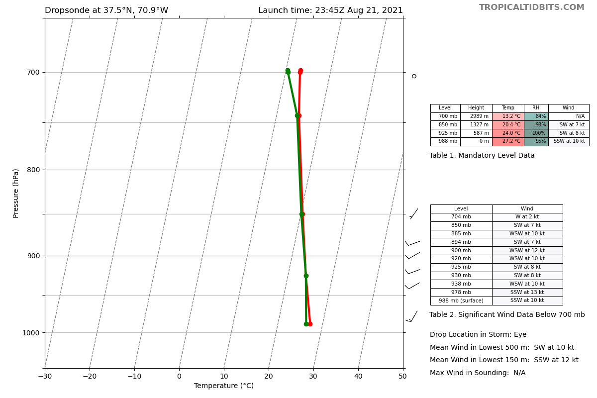
The eye is now saturated to 850mb
Best its been so far.
Could see some pretty good eyewall building tonight especially since the upper atmosphere is cooling off after sunset.

Image
2 likes   

User avatar
pgoss11
Category 2
Category 2
Posts: 702
Joined: Tue Sep 02, 2003 3:55 pm

Re: ATL: HENRI - Hurricane - Discussion

#675 Postby pgoss11 » Sat Aug 21, 2021 7:59 pm

wxman57 wrote:It'll be moving inland east of Long Island. Too far east of the forecast now. TVCN (consensus) into western Narragansett Bay - Rhode Island at 4pm tomorrow. Sped up a good bit.

Do you think the surge will be bad in Narragansett Bay?
0 likes   

StormPyrate
Category 1
Category 1
Posts: 279
Joined: Sun May 27, 2018 8:41 pm
Location: Clearwater, FL

Re: ATL: HENRI - Hurricane - Discussion

#676 Postby StormPyrate » Sat Aug 21, 2021 8:05 pm

Definitely looks to be off the official track to the east
0 likes   
St Petersburg Florida

User avatar
GCANE
S2K Supporter
S2K Supporter
Posts: 11496
Joined: Mon Oct 22, 2007 8:03 am

Re: ATL: HENRI - Hurricane - Discussion

#677 Postby GCANE » Sat Aug 21, 2021 8:05 pm

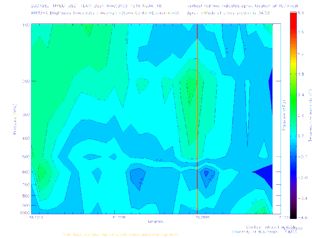
Interesting.
Warm core has improved today but cold pool has diminished.
Maybe we could see a quick flash of convection if the warm core can maintain itself and Henri transitions from the Gulf Stream to the cold water.
See how it goes.

Imageprogram for screenshots for windows
0 likes   

User avatar
wxman57
Moderator-Pro Met
Moderator-Pro Met
Posts: 22978
Age: 67
Joined: Sat Jun 21, 2003 8:06 pm
Location: Houston, TX (southwest)

Re: ATL: HENRI - Hurricane - Discussion

#678 Postby wxman57 » Sat Aug 21, 2021 8:06 pm

pgoss11 wrote:
wxman57 wrote:It'll be moving inland east of Long Island. Too far east of the forecast now. TVCN (consensus) into western Narragansett Bay - Rhode Island at 4pm tomorrow. Sped up a good bit.

Do you think the surge will be bad in Narragansett Bay?


I'm not that familiar with the bay. Here's a SLOSH display for a Cat 1 of average size moving into the bay. Henri will be below-average in size and may be a TS, so the surge will likely be below the values on the graphic. 2-3 ft doesn't look so bad. I'm thinking it may move east of Narragansett Bay, though. The way it's tracking east of the forecast, it may miss the bay to the east. Core looks terrible on satellite, by the way.

Image
1 likes   

User avatar
ConvergenceZone
Category 5
Category 5
Posts: 5194
Joined: Fri Jul 29, 2005 1:40 am
Location: Northern California

Re: ATL: HENRI - Hurricane - Discussion

#679 Postby ConvergenceZone » Sat Aug 21, 2021 8:08 pm

wxman57 wrote:It'll be moving inland east of Long Island. Too far east of the forecast now. TVCN (consensus) into western Narragansett Bay - Rhode Island at 4pm tomorrow. Sped up a good bit.


Nice!!! Glad to see that NY dodged the bullet! Perhaps it will move even further east and avoid the USA all-together, or maybe just clip Rhode Island
0 likes   

User avatar
InfernoFlameCat
Category 5
Category 5
Posts: 2102
Age: 22
Joined: Mon Dec 14, 2020 10:52 am
Location: Buford, GA

Re: ATL: HENRI - Hurricane - Discussion

#680 Postby InfernoFlameCat » Sat Aug 21, 2021 8:09 pm

Henri is finally acting like it’s over 30C waters. It was behaving more like 26C than thirty today
0 likes   
I am by no means a professional. DO NOT look at my forecasts for official information or make decisions based on what I post.

Goal: to become a registered expert over tropical and subtropical cyclones.


Return to “2021”

Who is online

Users browsing this forum: No registered users and 6 guests