
Unless I'm mistaken, looks like the dry slot is already getting mixed out.
Cloud tops not as cold as earlier, but IIRC that's normal for hurricanes trying to clear an eye.
ATL: GRACE - Remnants - Discussion
Moderator: S2k Moderators
Re: ATL: GRACE - Hurricane - Discussion
1 likes
TC naming lists: retirements and intensity
Most aggressive Advisory #1's in North Atlantic (cr. kevin for starting the list)
Most aggressive Advisory #1's in North Atlantic (cr. kevin for starting the list)
-
ElectricStorm

- Category 5

- Posts: 5148
- Age: 25
- Joined: Tue Aug 13, 2019 11:23 pm
- Location: Norman, OK
Re: ATL: GRACE - Hurricane - Discussion
Dry slot appears to be filling in pretty quickly now. Sticking with my 100kt landfall prediction
0 likes
B.S Meteorology, University of Oklahoma '25
Please refer to the NHC, NWS, or SPC for official information.
Please refer to the NHC, NWS, or SPC for official information.
-
HurricaneEnzo

- Category 2

- Posts: 744
- Joined: Wed Mar 14, 2018 12:18 pm
- Location: Newport, NC (Hurricane Alley)
Re: ATL: GRACE - Hurricane - Discussion
My landfall guess is 90kts/973mb
0 likes
Bertha 96' - Fran 96' - Bonnie 98' - Dennis 99' - Floyd 99' - Isabel 03' - Alex 04' - Ophelia 05' - Irene 11' - Arthur 14' - Matthew 16' - Florence 18' - Dorian 19' - Isaias 20' (countless other tropical storms and Hurricane swipes)
I am not a Professional Met just an enthusiast. Get your weather forecasts from the Pros!
I am not a Professional Met just an enthusiast. Get your weather forecasts from the Pros!

Re: ATL: GRACE - Hurricane - Discussion
Of course AF302’s barometer is broken. This plane has been having problems all season.
0 likes
Irene '11 Sandy '12 Hermine '16 5/15/2018 Derecho Fay '20 Isaias '20 Elsa '21 Henri '21 Ida '21
I am only a meteorology enthusiast who knows a decent amount about tropical cyclones. Look to the professional mets, the NHC, or your local weather office for the best information.
I am only a meteorology enthusiast who knows a decent amount about tropical cyclones. Look to the professional mets, the NHC, or your local weather office for the best information.
-
ElectricStorm
- Category 5
- Posts: 5148
- Age: 25
- Joined: Tue Aug 13, 2019 11:23 pm
- Location: Norman, OK
Re: ATL: GRACE - Hurricane - Discussion
Looks like an eye may be trying to appear on visible. Convection in that spot it warming on IR with towers going up around it. I think we'll be seeing the eye clear out over the next couple hours.
3 likes
B.S Meteorology, University of Oklahoma '25
Please refer to the NHC, NWS, or SPC for official information.
Please refer to the NHC, NWS, or SPC for official information.
Re: ATL: GRACE - Hurricane - Discussion
Appears the pressure is 981mb now. Intensification seems to have leveled off. Microwave images look as if it might have a larger eye which won’t intensify as fast as a smaller, more compact core. I’m guessing 976-77mb for landfall. Winds 75-80kts.
1 likes
Solar Aquarian
Lunar Cancerian
 Sagittarian
Lunar Cancerian
-
Sciencerocks
- Category 5
- Posts: 10186
- Age: 40
- Joined: Thu Jul 06, 2017 1:51 am
-
HurricaneEnzo
- Category 2
- Posts: 744
- Joined: Wed Mar 14, 2018 12:18 pm
- Location: Newport, NC (Hurricane Alley)
Re: ATL: GRACE - Hurricane - Discussion
Nice blowup of overshooting tops around the COC. Might be ready to start another round of intensification.
1 likes
Bertha 96' - Fran 96' - Bonnie 98' - Dennis 99' - Floyd 99' - Isabel 03' - Alex 04' - Ophelia 05' - Irene 11' - Arthur 14' - Matthew 16' - Florence 18' - Dorian 19' - Isaias 20' (countless other tropical storms and Hurricane swipes)
I am not a Professional Met just an enthusiast. Get your weather forecasts from the Pros!
I am not a Professional Met just an enthusiast. Get your weather forecasts from the Pros!
-
cycloneye

- Admin

- Posts: 149553
- Age: 69
- Joined: Thu Oct 10, 2002 10:54 am
- Location: San Juan, Puerto Rico
Re: ATL: GRACE - Hurricane - Discussion
The latest VDM has a 35 mile wide eye and open to the NW.
F. OPEN NW
G. C35
G. C35
1 likes
Visit the Caribbean-Central America Weather Thread where you can find at first post web cams,radars
and observations from Caribbean basin members Click Here
and observations from Caribbean basin members Click Here
-
ElectricStorm
- Category 5
- Posts: 5148
- Age: 25
- Joined: Tue Aug 13, 2019 11:23 pm
- Location: Norman, OK
Re: ATL: GRACE - Hurricane - Discussion
E eyewall drop has 64kt surface winds but much stronger winds just above the surface. Hopefully those don't mix down.
0 likes
B.S Meteorology, University of Oklahoma '25
Please refer to the NHC, NWS, or SPC for official information.
Please refer to the NHC, NWS, or SPC for official information.
-
Iceresistance

- Category 5
- Posts: 9598
- Age: 22
- Joined: Sat Oct 10, 2020 9:45 am
- Location: Tecumseh, OK/Norman, OK
Re: ATL: GRACE - Hurricane - Discussion
980 MB with 6 knot winds at the Eye . . .

0 likes
Bill 2015 & Beta 2020
Winter 2020-2021
All observations are in Tecumseh, OK unless otherwise noted.
Winter posts are focused mainly for Oklahoma & Texas.
Take any of my forecasts with a grain of salt, refer to the NWS, SPC, and NHC for official information
Never say Never with weather! Because ANYTHING is possible!
Winter 2020-2021
All observations are in Tecumseh, OK unless otherwise noted.
Winter posts are focused mainly for Oklahoma & Texas.
Take any of my forecasts with a grain of salt, refer to the NWS, SPC, and NHC for official information
Never say Never with weather! Because ANYTHING is possible!
-
cycloneye
- Admin
- Posts: 149553
- Age: 69
- Joined: Thu Oct 10, 2002 10:54 am
- Location: San Juan, Puerto Rico
Re: ATL: GRACE - Hurricane - Discussion
URNT12 KNHC 201715
VORTEX DATA MESSAGE AL072021
A. 20/16:49:50Z
B. 20.55 deg N 094.44 deg W
C. 850 mb 1254 m
D. 980 mb
E. 070 deg 6 kt
F. OPEN W
G. C28
H. 64 kt
I. 083 deg 39 nm 16:37:30Z
J. 172 deg 89 kt
K. 072 deg 12 nm 16:46:00Z
L. 71 kt
M. 349 deg 17 nm 16:56:00Z
N. 094 deg 89 kt
O. 349 deg 18 nm 16:56:30Z
P. 16 C / 1526 m
Q. 22 C / 1525 m
R. NA / NA
S. 12345 / 08
T. 0.02 / 3.5 nm
U. AF303 1807A GRACE OB 28
MAX FL WIND 89 KT 072 / 12 NM 16:46:00Z
0 likes
Visit the Caribbean-Central America Weather Thread where you can find at first post web cams,radars
and observations from Caribbean basin members Click Here
and observations from Caribbean basin members Click Here
Re: ATL: GRACE - Hurricane - Discussion
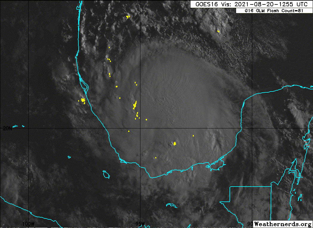
The LLC is now smack in the middle of a CDO with <-75C cloud tops. Recon confirms the eye is still open, but has shrunk from 32 to 28 nautical miles between passes, and the central pressure appears to be 979 mbar. Looks like recon is heading out now. I’ll guess the next flight finds an 80-85 kt Cat 1/2 with a pressure in the mid 970s.
2 likes
Irene '11 Sandy '12 Hermine '16 5/15/2018 Derecho Fay '20 Isaias '20 Elsa '21 Henri '21 Ida '21
I am only a meteorology enthusiast who knows a decent amount about tropical cyclones. Look to the professional mets, the NHC, or your local weather office for the best information.
I am only a meteorology enthusiast who knows a decent amount about tropical cyclones. Look to the professional mets, the NHC, or your local weather office for the best information.

Re: ATL: GRACE - Hurricane - Discussion
aspen wrote:The LLC is now smack in the middle of a CDO with <-75C cloud tops. Recon confirms the eye is still open, but has shrunk from 32 to 28 nautical miles between passes, and the central pressure appears to be 979 mbar. Looks like recon is heading out now. I’ll guess the next flight finds an 80-85 kt Cat 1/2 with a pressure in the mid 970s.
Do you know when the next recon will arrive?
0 likes
Re: ATL: GRACE - Hurricane - Discussion
The new blowup seems to have vastly improved the storm's structure. Just 1 hour ago the SE 65 kt radius was 0 miles (so non-existent) and now it's almost symmetric: 25/20/20/25. I expect the next recon to find a significantly stronger system, if I had to guess an 85 - 90 kt cat 2.
3 likes
-
Yellow Evan

- Professional-Met

- Posts: 16242
- Age: 27
- Joined: Fri Jul 15, 2011 12:48 pm
- Location: Henderson, Nevada/Honolulu, HI
- Contact:
Re: ATL: GRACE - Hurricane - Discussion
Worthy of T5.0 via an embedded center pattern. I hope the NHC is willing to break rules here and raise the winds though after Karl and how weirdly uncorrelated its appearance was with the actual winds, they might not.
0 likes
Re: ATL: GRACE - Hurricane - Discussion
kevin wrote:aspen wrote:The LLC is now smack in the middle of a CDO with <-75C cloud tops. Recon confirms the eye is still open, but has shrunk from 32 to 28 nautical miles between passes, and the central pressure appears to be 979 mbar. Looks like recon is heading out now. I’ll guess the next flight finds an 80-85 kt Cat 1/2 with a pressure in the mid 970s.
Do you know when the next recon will arrive?
No, but based on the recon timings of the last few days, I think the next one will head off at 4pm.
2 likes
Irene '11 Sandy '12 Hermine '16 5/15/2018 Derecho Fay '20 Isaias '20 Elsa '21 Henri '21 Ida '21
I am only a meteorology enthusiast who knows a decent amount about tropical cyclones. Look to the professional mets, the NHC, or your local weather office for the best information.
I am only a meteorology enthusiast who knows a decent amount about tropical cyclones. Look to the professional mets, the NHC, or your local weather office for the best information.
Re: ATL: GRACE - Hurricane - Discussion
Looks like Grace is exploding, you can see the shockwaves propagating out from the explosive development that is happening. This is a 2 hour loop using GOES-16 Red Band with CIRA Optical Depth overlaid.
Source - https://col.st/Rkzor
Source - https://col.st/Rkzor
Last edited by ChrisH-UK on Fri Aug 20, 2021 1:28 pm, edited 1 time in total.
0 likes
Re: ATL: GRACE - Hurricane - Discussion
RIP Grace’s floater privileges. 5-minute imagery will have to do.
0 likes
Irene '11 Sandy '12 Hermine '16 5/15/2018 Derecho Fay '20 Isaias '20 Elsa '21 Henri '21 Ida '21
I am only a meteorology enthusiast who knows a decent amount about tropical cyclones. Look to the professional mets, the NHC, or your local weather office for the best information.
I am only a meteorology enthusiast who knows a decent amount about tropical cyclones. Look to the professional mets, the NHC, or your local weather office for the best information.
Re: ATL: GRACE - Hurricane - Discussion
This will be the first major of the year looks like nothing will stop it from making a run at cat 3 status.
0 likes
Who is online
Users browsing this forum: No registered users and 19 guests