ATL: GRACE - Remnants - Discussion

Moderator: S2k Moderators

Message
Author
User avatar
aspen
Category 5
Category 5
Posts: 8818
Joined: Sat Oct 12, 2019 7:10 pm
Location: Connecticut, USA

Re: ATL: GRACE - Tropical Storm - Discussion

#1301 Postby aspen » Fri Aug 20, 2021 6:30 am

kevin wrote:982.6 mbar :double:! First pass by recon, now also updated on TropicalAtlantic. Looks like Grace is back at hurricane strength and earlier than forecast by the already agressive HMON and HWRF.

Extrapolated Sfc. Pressure = 982.6 mbar
SFMR = 74 kt
Est. Sfc. Wind = 72 kt

And it doesn’t make landfall until midnight…a Cat 3 is looking a lot more plausible now. The next pass will tell us how quickly it’s deepening.
1 likes   
Irene '11 Sandy '12 Hermine '16 5/15/2018 Derecho Fay '20 Isaias '20 Elsa '21 Henri '21 Ida '21

I am only a meteorology enthusiast who knows a decent amount about tropical cyclones. Look to the professional mets, the NHC, or your local weather office for the best information.

User avatar
aspen
Category 5
Category 5
Posts: 8818
Joined: Sat Oct 12, 2019 7:10 pm
Location: Connecticut, USA

Re: ATL: GRACE - Tropical Storm - Discussion

#1302 Postby aspen » Fri Aug 20, 2021 6:39 am

Center drop was 984/12, supporting 982 or 983mb.
0 likes   
Irene '11 Sandy '12 Hermine '16 5/15/2018 Derecho Fay '20 Isaias '20 Elsa '21 Henri '21 Ida '21

I am only a meteorology enthusiast who knows a decent amount about tropical cyclones. Look to the professional mets, the NHC, or your local weather office for the best information.

User avatar
ElectricStorm
Category 5
Category 5
Posts: 5044
Age: 24
Joined: Tue Aug 13, 2019 11:23 pm
Location: Skiatook, OK / Norman, OK

Re: ATL: GRACE - Tropical Storm - Discussion

#1303 Postby ElectricStorm » Fri Aug 20, 2021 6:42 am

Wow that's exactly what I did NOT want to see when I woke up. That's 10mb deeper than the 0z HMON and HWRF showed for now. And both of them got down to the 960's
1 likes   
B.S Meteorology, University of Oklahoma '25

Please refer to the NHC, NWS, or SPC for official information.

AlphaToOmega
Category 5
Category 5
Posts: 1448
Joined: Sat Jun 26, 2021 10:51 am
Location: Somewhere in Massachusetts

Re: ATL: GRACE - Hurricane - Discussion

#1304 Postby AlphaToOmega » Fri Aug 20, 2021 6:53 am

That was some quick intensification.
0 likes   

Chris90
Category 2
Category 2
Posts: 646
Age: 35
Joined: Thu Jun 01, 2017 9:36 pm

Re: ATL: GRACE - Hurricane - Discussion

#1305 Postby Chris90 » Fri Aug 20, 2021 6:53 am

I was not really expecting Grace to be this far along already. I thought she was more likely going to have a pressure around 988-992mb. 92kt flight level winds were also a bit more than I expected. Increased chances for a major at this point I would say, which is unfortunate for Mexico. I didn’t really think she would have enough time, but at this point it doesn’t look like it’ll be an issue.
0 likes   
Solar Aquarian
Lunar Cancerian
:uarrow: Sagittarian

User avatar
cycloneye
Admin
Admin
Posts: 145296
Age: 68
Joined: Thu Oct 10, 2002 10:54 am
Location: San Juan, Puerto Rico

Re: ATL: GRACE - Hurricane - Discussion

#1306 Postby cycloneye » Fri Aug 20, 2021 6:58 am

0 likes   
Visit the Caribbean-Central America Weather Thread where you can find at first post web cams,radars
and observations from Caribbean basin members Click Here

ThetaE
Tropical Storm
Tropical Storm
Posts: 244
Joined: Sat Sep 24, 2016 4:50 pm
Location: Boston

Re: ATL: GRACE - Tropical Storm - Discussion

#1307 Postby ThetaE » Fri Aug 20, 2021 7:02 am

aspen wrote:Center drop was 984/12, supporting 982 or 983mb.


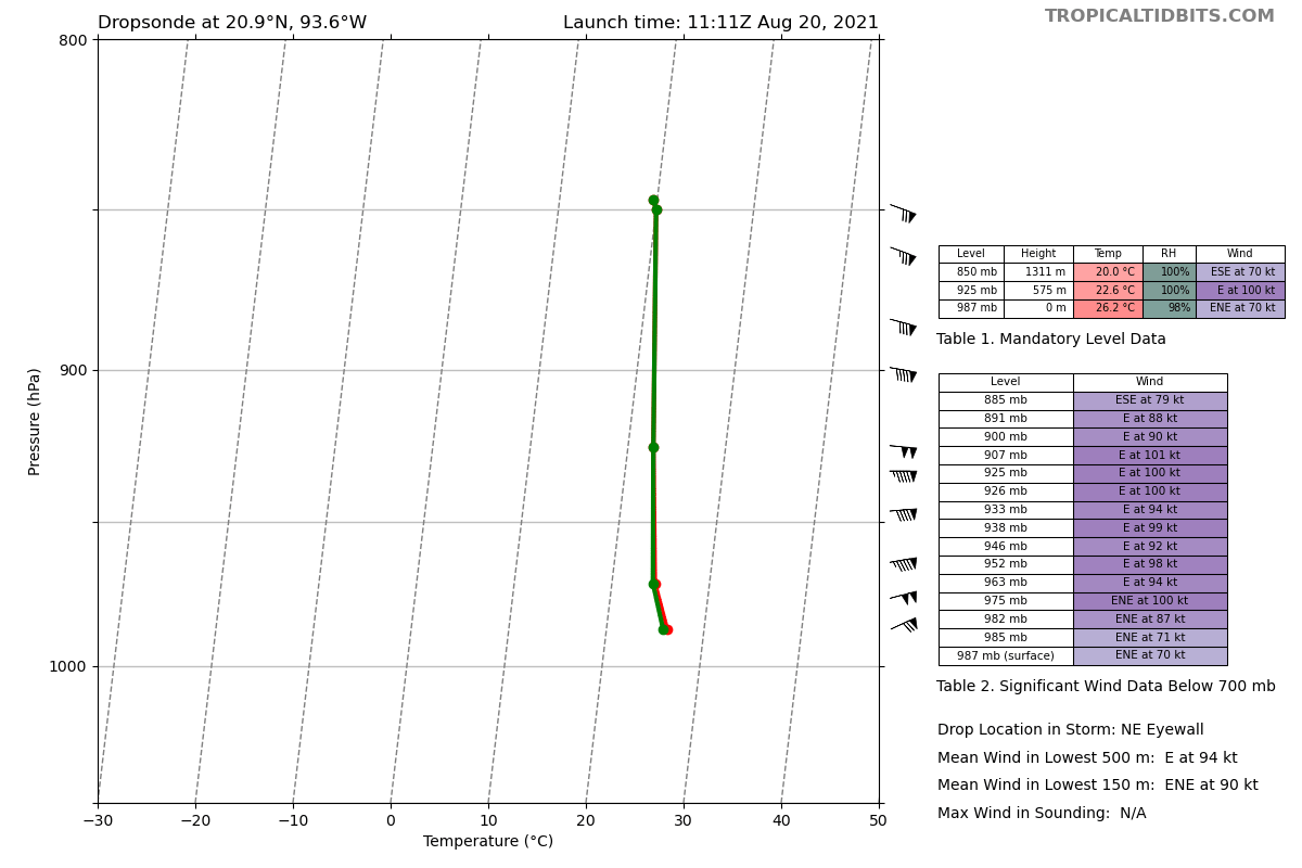
Some extra thought should probably be given to the typical pressure reduction, since the AF plane showed a pretty interesting structure. Overall, I think Grace has a surprisingly broad/flat eye for such a strong NE quadrant and pressure above 980mb. This is best explained by what appears to be a mesovortex on the NE side, with the 982.6 mb minimum being measured in a region of ~40kt sfc and flight level winds. The wind shift, on the other hand, happened on the SW side of the eye (extrap. 985.3 mb).

Based on lat/lon, looks liked that center dropsonde was at the wind shift, not the mesovort. Not sure how the NHC typically handles these features, but you could make an argument for 979-980 mb inside the mesovortex.

Image
1 likes   
I'm a busy grad student, not a professional forecaster. Please refer to the NHC and NWS for official forecasts.

User avatar
Owasso
Category 1
Category 1
Posts: 309
Joined: Sat Aug 22, 2020 11:14 pm
Location: Chicago, Illinois

Re: ATL: GRACE - Hurricane - Discussion

#1308 Postby Owasso » Fri Aug 20, 2021 7:04 am

Image

100kt winds just above the surface :eek:
3 likes   

User avatar
Hypercane_Kyle
Category 5
Category 5
Posts: 3352
Joined: Sat Mar 07, 2015 7:58 pm
Location: Cape Canaveral, FL

Re: ATL: GRACE - Hurricane - Discussion

#1309 Postby Hypercane_Kyle » Fri Aug 20, 2021 7:12 am

Bay of Campeche working its magic unfortunately. Reminds me of Karl in 2010.
3 likes   
My posts are my own personal opinion, defer to the National Hurricane Center (NHC) and other NOAA products for decision making during hurricane season.

User avatar
cheezyWXguy
Category 5
Category 5
Posts: 6108
Joined: Mon Feb 13, 2006 12:29 am
Location: Dallas, TX

Re: ATL: GRACE - Hurricane - Discussion

#1310 Postby cheezyWXguy » Fri Aug 20, 2021 7:13 am

This has major written all over it. First visible of the day appears to be revealing overshooting tips surrounding a developing mid level eye.
1 likes   

User avatar
ElectricStorm
Category 5
Category 5
Posts: 5044
Age: 24
Joined: Tue Aug 13, 2019 11:23 pm
Location: Skiatook, OK / Norman, OK

Re: ATL: GRACE - Hurricane - Discussion

#1311 Postby ElectricStorm » Fri Aug 20, 2021 7:13 am

It's about halfway across the BOC and it's already at the NHC's landfall intensity :eek:
Karl in 2010 blew up almost to a Cat 4 on a similar track. Hopefully Grace doesn't do the same
0 likes   
B.S Meteorology, University of Oklahoma '25

Please refer to the NHC, NWS, or SPC for official information.

User avatar
kevin
Category 5
Category 5
Posts: 2586
Age: 26
Joined: Wed Aug 28, 2019 4:35 am

Re: ATL: GRACE - Hurricane - Discussion

#1312 Postby kevin » Fri Aug 20, 2021 7:26 am

Grace now also officially back to hurricane status.
0 likes   

User avatar
ElectricStorm
Category 5
Category 5
Posts: 5044
Age: 24
Joined: Tue Aug 13, 2019 11:23 pm
Location: Skiatook, OK / Norman, OK

Re: ATL: GRACE - Hurricane - Discussion

#1313 Postby ElectricStorm » Fri Aug 20, 2021 7:34 am

982.8 extrap
0 likes   
B.S Meteorology, University of Oklahoma '25

Please refer to the NHC, NWS, or SPC for official information.

tolakram
Admin
Admin
Posts: 20009
Age: 62
Joined: Sun Aug 27, 2006 8:23 pm
Location: Florence, KY (name is Mark)

Re: ATL: GRACE - Hurricane - Discussion

#1314 Postby tolakram » Fri Aug 20, 2021 7:40 am

1 likes   
M a r k
- - - - -
Join us in chat: Storm2K Chatroom Invite. Android and IOS apps also available.

The posts in this forum are NOT official forecasts and should not be used as such. Posts are NOT endorsed by any professional institution or STORM2K.org. For official information and forecasts, please refer to NHC and NWS products.

tolakram
Admin
Admin
Posts: 20009
Age: 62
Joined: Sun Aug 27, 2006 8:23 pm
Location: Florence, KY (name is Mark)

Re: ATL: GRACE - Hurricane - Discussion

#1315 Postby tolakram » Fri Aug 20, 2021 7:50 am

saved Radar loop

Image
2 likes   
M a r k
- - - - -
Join us in chat: Storm2K Chatroom Invite. Android and IOS apps also available.

The posts in this forum are NOT official forecasts and should not be used as such. Posts are NOT endorsed by any professional institution or STORM2K.org. For official information and forecasts, please refer to NHC and NWS products.

User avatar
Iceresistance
Category 5
Category 5
Posts: 9288
Age: 21
Joined: Sat Oct 10, 2020 9:45 am
Location: Tecumseh, OK/Norman, OK

Re: ATL: GRACE - Hurricane - Discussion

#1316 Postby Iceresistance » Fri Aug 20, 2021 7:53 am

982.9 being reported several times, lowest was 982.8 (Reported twice on the previous update)

Image
0 likes   
Bill 2015 & Beta 2020

Winter 2020-2021 :cold:

All observations are in Tecumseh, OK unless otherwise noted.

Winter posts are focused mainly for Oklahoma & Texas.

Take any of my forecasts with a grain of salt, refer to the NWS, SPC, and NHC for official information

Never say Never with weather! Because ANYTHING is possible!

User avatar
ElectricStorm
Category 5
Category 5
Posts: 5044
Age: 24
Joined: Tue Aug 13, 2019 11:23 pm
Location: Skiatook, OK / Norman, OK

Re: ATL: GRACE - Hurricane - Discussion

#1317 Postby ElectricStorm » Fri Aug 20, 2021 8:02 am

Eye drop supports 982mb
0 likes   
B.S Meteorology, University of Oklahoma '25

Please refer to the NHC, NWS, or SPC for official information.

User avatar
aspen
Category 5
Category 5
Posts: 8818
Joined: Sat Oct 12, 2019 7:10 pm
Location: Connecticut, USA

Re: ATL: GRACE - Hurricane - Discussion

#1318 Postby aspen » Fri Aug 20, 2021 8:02 am

That crescent-shape CDO with a possible dry slot in the south could limit intensification for the time being.
1 likes   
Irene '11 Sandy '12 Hermine '16 5/15/2018 Derecho Fay '20 Isaias '20 Elsa '21 Henri '21 Ida '21

I am only a meteorology enthusiast who knows a decent amount about tropical cyclones. Look to the professional mets, the NHC, or your local weather office for the best information.

User avatar
Teban54
Category 5
Category 5
Posts: 3204
Joined: Sat May 19, 2018 1:19 pm

Re: ATL: GRACE - Hurricane - Discussion

#1319 Postby Teban54 » Fri Aug 20, 2021 8:11 am

aspen wrote:That crescent-shape CDO with a possible dry slot in the south could limit intensification for the time being.


Grace had that structure for a few hours already, and that didn't seem to stop it from intensifying. I remember Teddy also looked similar as a Cat 2 with a semi-circle-like CDO on the eastern side.
2 likes   

User avatar
ElectricStorm
Category 5
Category 5
Posts: 5044
Age: 24
Joined: Tue Aug 13, 2019 11:23 pm
Location: Skiatook, OK / Norman, OK

Re: ATL: GRACE - Hurricane - Discussion

#1320 Postby ElectricStorm » Fri Aug 20, 2021 8:24 am

That is a pretty decent dry slot there but so far it hasn't done much to stop strengthening. Hopefully Grace won't be able to close it off but with all that convection I would think it would close off eventually.
0 likes   
B.S Meteorology, University of Oklahoma '25

Please refer to the NHC, NWS, or SPC for official information.


Return to “2021”

Who is online

Users browsing this forum: No registered users and 6 guests