ATL: HENRI - Remnants - Discussion
Moderator: S2k Moderators
-
Shell Mound
- Category 5

- Posts: 2432
- Age: 33
- Joined: Thu Sep 07, 2017 3:39 pm
- Location: St. Petersburg, FL → Scandinavia
Re: ATL: HENRI - Tropical Storm - Discussion
One bit of good news is that Henri is not following the strongest guidance thus far. According to the strongest EPS members, Henri should have been moving WSW by now, yet it is moving WNW. While landfall on New England is now becoming quite likely, it is not likely to occur farther west than the vicinity of Newport, RI, and is not likely to be stronger than a high-end tropical storm at landfall. The members that show Henri moving WNW during the current timeframe all show Henri peaking as a low-end hurricane and then making landfall as a strong tropical storm. Conversely, the members that show Henri moving WSW as of now indicate a stronger peak and a landfall farther west on Long Island, NY.
1 likes
CVW / MiamiensisWx / Shell Mound
The posts in this forum are NOT official forecasts and should not be used as such. They are just the opinion of the poster and may or may not be backed by sound meteorological data. They are NOT endorsed by any professional institution or STORM2K. For official information, please refer to products from the NHC and NWS.
-
hohnywx
- Category 2

- Posts: 511
- Age: 35
- Joined: Sun Jul 19, 2009 8:34 pm
- Location: Hastings-on-Hudson, NY
Re: ATL: HENRI - Tropical Storm - Discussion
Watches have been hoisted. Let the preps begin in earnest.
WATCHES AND WARNINGS
--------------------
CHANGES WITH THIS ADVISORY:
A Storm Surge Watch has been issued for the south shore of Long
Island from East Rockaway Inlet eastward to Montauk, the north
shore of Long Island from Kings Point eastward to Montauk, and from
Kings Point eastward to Sagamore Beach, Massachusetts, including
Nantucket, Martha's Vineyard, and Block Island.
A Hurricane Watch has been issued for Long Island from Fire Island
Inlet eastward and from Port Jefferson Harbor eastward. A
Hurricane Watch has also been issued from New Haven, Connecticut,
eastward to Sagamore Beach, Massachusetts, including Nantucket,
Martha's Vineyard, and Block Island.
A Tropical Storm Watch has been issued west of Fire Island Inlet to
East Rockaway Inlet, west of Port Jefferson Harbor, and west of New
Haven.
SUMMARY OF WATCHES AND WARNINGS IN EFFECT:
A Storm Surge Watch is in effect for...
* South Shore of Long Island from East Rockaway Inlet to Montauk
* North Shore of Long Island from Kings Point to Montauk
* Kings Point New York to Sagamore Beach Massachusetts
* Nantucket, Martha's Vineyard, and Block Island
A Hurricane Watch is in effect for...
* South Shore of Long Island from Fire Island Inlet to Montauk
* North Shore of Long Island from Port Jefferson Harbor to Montauk
* New Haven Connecticut to Sagamore Beach Massachusetts
* Nantucket, Martha's Vineyard, and Block Island
A Tropical Storm Watch is in effect for...
* West of Fire Island Inlet to East Rockaway Inlet New York
* West of Port Jefferson Harbor New York
* West of New Haven Connecticut
A Storm Surge Watch means there is a possibility of life-
threatening inundation, from rising water moving inland from the
coastline, in the indicated locations during the next 48 hours.
For a depiction of areas at risk, please see the National Weather
Service Storm Surge Watch/Warning Graphic, available at
hurricanes.gov.
A Hurricane Watch means that hurricane conditions are possible
within the watch area. A watch is typically issued 48 hours
before the anticipated first occurrence of tropical-storm-force
winds, conditions that make outside preparations difficult or
dangerous.
A Tropical Storm Watch means that tropical storm conditions are
possible within the watch area, generally within 48 hours.
Interests elsewhere in the northeastern U.S. and Atlantic Canada
should monitor the progress of Henri. Additional watches or
warnings will likely be required later today.
For storm information specific to your area, including possible
inland watches and warnings, please monitor products issued by your local National Weather Service forecast office.
2 likes

Re: ATL: HENRI - Tropical Storm - Discussion
NHC now explicitly showing a hurricane landfall. Stay safe everyone in the area and make sure you're prepped.

2 likes

Re: ATL: HENRI - Tropical Storm - Discussion
kevin wrote:NHC now explicitly showing a hurricane landfall. Stay safe everyone in the area and make sure you're prepped.
https://i.imgur.com/ndcHKy5.png
maybe 29.9 or 30N, I get it's only .2 off but everything matters with this storm, recon speed up haha
0 likes
Once I see the REDS and GREENS Converge on a Base Velocity. ... I'm There!!
This is NOT an Official Forecast....Just my Opinion. For official information, please refer to the NHC and NWS products.
HIGHLIGHTS : '13 El Reno Tornado : 2013 Storm Chaser Tour, Joaquin; SC flood event, Matthew '16, Lowcountry Snow storm Jan '18
This is NOT an Official Forecast....Just my Opinion. For official information, please refer to the NHC and NWS products.
HIGHLIGHTS : '13 El Reno Tornado : 2013 Storm Chaser Tour, Joaquin; SC flood event, Matthew '16, Lowcountry Snow storm Jan '18

Re: ATL: HENRI - Tropical Storm - Discussion
Unfortunately henri is looking very impressive this morning, can see eye lash clouds coming out from it now, a good sign of it strengthing, will be very interesting what the recon finds
0 likes
-
wxman57

- Moderator-Pro Met

- Posts: 23175
- Age: 68
- Joined: Sat Jun 21, 2003 8:06 pm
- Location: Houston, TX (southwest)
Re: ATL: HENRI - Tropical Storm - Discussion
Better check the microwave. Center is detached to the north.

6 likes

Re: ATL: HENRI - Tropical Storm - Discussion
wxman57 wrote:Better check the microwave. Center is detached to the north.
http://wxman57.com/images/microwave.JPG
Looks more offset than yesterday, but the MLC also looks more potent. Could the LLC be dragged back south under the strong MLC when shear drops later today? Or would the MLC be the one pulled north?
1 likes
Irene '11 Sandy '12 Hermine '16 5/15/2018 Derecho Fay '20 Isaias '20 Elsa '21 Henri '21 Ida '21
I am only a meteorology enthusiast who knows a decent amount about tropical cyclones. Look to the professional mets, the NHC, or your local weather office for the best information.
I am only a meteorology enthusiast who knows a decent amount about tropical cyclones. Look to the professional mets, the NHC, or your local weather office for the best information.
-
AlphaToOmega
- Category 5
- Posts: 1448
- Joined: Sat Jun 26, 2021 10:51 am
- Location: Somewhere in Massachusetts
-
wxman57
- Moderator-Pro Met
- Posts: 23175
- Age: 68
- Joined: Sat Jun 21, 2003 8:06 pm
- Location: Houston, TX (southwest)
Re: ATL: HENRI - Tropical Storm - Discussion
aspen wrote:wxman57 wrote:Better check the microwave. Center is detached to the north.
http://wxman57.com/images/microwave.JPG
Looks more offset than yesterday, but the MLC also looks more potent. Could the LLC be dragged back south under the strong MLC when shear drops later today? Or would the MLC be the one pulled north?
I'm sure it will recover when the shear drops off late this afternoon or this evening.
1 likes
-
wxman57
- Moderator-Pro Met
- Posts: 23175
- Age: 68
- Joined: Sat Jun 21, 2003 8:06 pm
- Location: Houston, TX (southwest)
Re: ATL: HENRI - Tropical Storm - Discussion
AlphaToOmega wrote:DHMO (dihydrogen monoxide) hazards
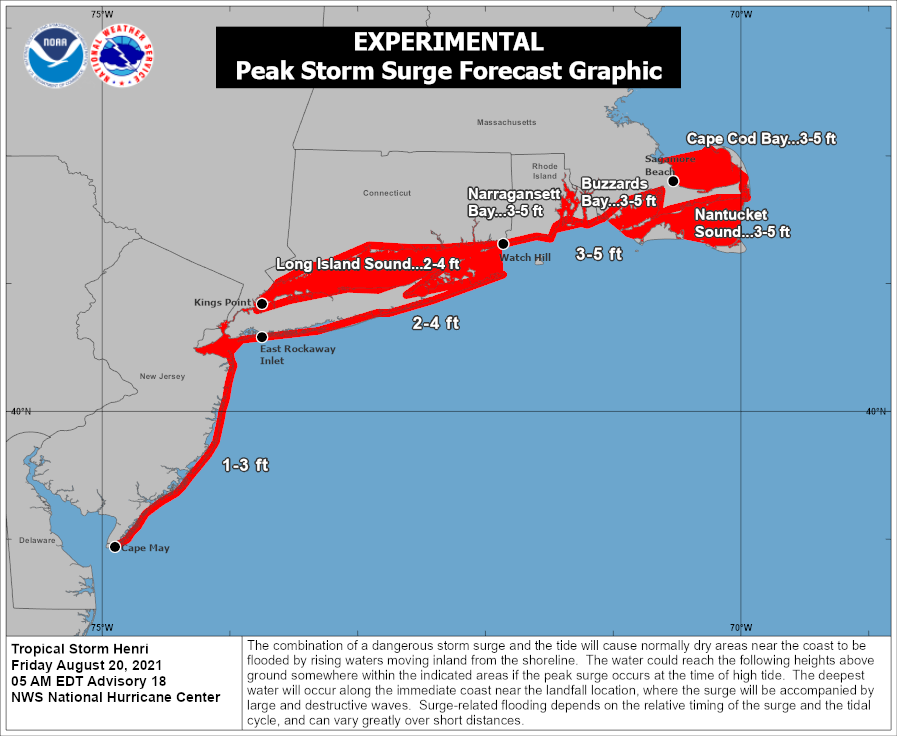
https://i.postimg.cc/VNxpqzYr/092851-peak-surge.png
Looks like a surge map, to me.
1 likes
-
weathaguyry

- Category 5
- Posts: 1273
- Age: 22
- Joined: Wed Jun 15, 2016 5:16 am
- Location: Long Island, NY
Re: ATL: HENRI - Tropical Storm - Discussion
Recon just heading in now, so we’ll see if Henri is deepening as it moves away from the shear. I’m currently at college in Albany (majoring in Atmospheric Science  ). If a W/WNW motion is still seen by recon this morning I may hop on a train back to Long Island for the weekend to help out my family with the storm.
3 likes
My posts are only my opinions and NOT official forecasts. For official forecasts, consult the National Hurricane Center or the National Weather Service.
Irene 11', Sandy 12', Fay 20’, Isaias 20’, Elsa 21’, Henri 21’, Ida 21’
Irene 11', Sandy 12', Fay 20’, Isaias 20’, Elsa 21’, Henri 21’, Ida 21’


Re: ATL: HENRI - Tropical Storm - Discussion
Seeing a significant shift in GFS forecast this morning on approach to New England.
Previously Henri was influenced by an ULL to its west.
That ULL has shifted south on the latest run.
Now looks like Henri will be under a ULH.
Also, CAPE & TPW entrainment is much higher on the latest run when Henri is in the region of 35N.
Previously Henri was influenced by an ULL to its west.
That ULL has shifted south on the latest run.
Now looks like Henri will be under a ULH.
Also, CAPE & TPW entrainment is much higher on the latest run when Henri is in the region of 35N.
2 likes
Re: ATL: HENRI - Tropical Storm - Discussion
Pressure looks to be around 998-999mb. Due to MLC/LLC offset from the shear, the center doesn’t look as good as yesterday, as implied by that microwave pass wxman posted.
0 likes
Irene '11 Sandy '12 Hermine '16 5/15/2018 Derecho Fay '20 Isaias '20 Elsa '21 Henri '21 Ida '21
I am only a meteorology enthusiast who knows a decent amount about tropical cyclones. Look to the professional mets, the NHC, or your local weather office for the best information.
I am only a meteorology enthusiast who knows a decent amount about tropical cyclones. Look to the professional mets, the NHC, or your local weather office for the best information.

Re: ATL: HENRI - Tropical Storm - Discussion
0 likes
Once I see the REDS and GREENS Converge on a Base Velocity. ... I'm There!!
This is NOT an Official Forecast....Just my Opinion. For official information, please refer to the NHC and NWS products.
HIGHLIGHTS : '13 El Reno Tornado : 2013 Storm Chaser Tour, Joaquin; SC flood event, Matthew '16, Lowcountry Snow storm Jan '18
This is NOT an Official Forecast....Just my Opinion. For official information, please refer to the NHC and NWS products.
HIGHLIGHTS : '13 El Reno Tornado : 2013 Storm Chaser Tour, Joaquin; SC flood event, Matthew '16, Lowcountry Snow storm Jan '18
Re: ATL: HENRI - Tropical Storm - Discussion
Seeing a big shift in the flow pattern of TPW air.
Henri is quickly pulling in High TPW air from across the south CONUS, the eastern Seaboard, and the Gulf Stream.
This is forecasted to increase.
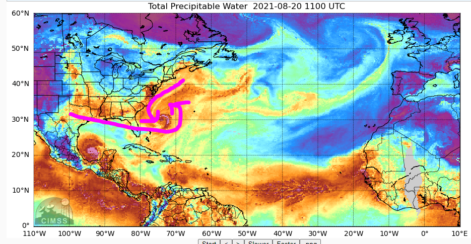
Henri is quickly pulling in High TPW air from across the south CONUS, the eastern Seaboard, and the Gulf Stream.
This is forecasted to increase.
2 likes

Re: ATL: HENRI - Tropical Storm - Discussion
Recon shows Henri's strongest winds are on the southern quadrant, evindence that it is still being affected by northerly shear this morning.
0 likes
Re: ATL: HENRI - Tropical Storm - Discussion
ScottNAtlanta wrote:Was the ULL just north of Henri forecast to be there?
https://i.imgur.com/B2xWsmS.gif
Check out Levi's latest, he spends a lot of time on that low and a high pressure area moving across the area to the north as well.
0 likes
Re: ATL: HENRI - Tropical Storm - Discussion
GCANE wrote:Seeing a significant shift in GFS forecast this morning on approach to New England.
Previously Henri was influenced by an ULL to its west.
That ULL has shifted south on the latest run.
Now looks like Henri will be under a ULH.
Also, CAPE & TPW entrainment is much higher on the latest run when Henri is in the region of 35N.
Forgot to mention that the shift of the ULL to the south has now put Long Island in the cross hairs.
Looks like it may be stronger than previously thought due to it now being under the ULH and the stronger high moisture infeed on its trek north.
2 likes
Re: ATL: HENRI - Tropical Storm - Discussion
First recon pass has the center is further south than the 8am position by about .2 degrees, also 70 mph winds
0 likes
Who is online
Users browsing this forum: No registered users and 18 guests