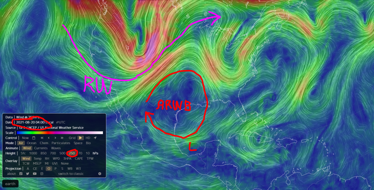
ATL: GRACE - Remnants - Discussion

Moderator: S2k Moderators

Message
Author
ChrisH-UK
Category 2
Category 2
Posts: 625
Joined: Sat May 29, 2021 8:22 am

Re: ATL: GRACE - Hurricane - Discussion

#1221 Postby ChrisH-UK » Thu Aug 19, 2021 7:15 am

Teban54 wrote:
ChrisH-UK wrote:(From earlier, i posted it to the wrong thread)

Belize Radar have it coming ashore south of Cozumel.

Source - http://nms.gov.bz/sensors/radar-imagery/

https://nms.gov.bz/images/radar/400/latest_400kmpic.gif?t=1629365860


Seems like you posted the original image instead of saving it and re-uploading to an external site (like imgur). As a result, this image shows Grace further inland than when you first posted it, and in a few days people who look at this post will see nothing.

Refer to this post for how to post images.


Thanks fixed it now.
1 likes   

NXStumpy_Robothing
Category 1
Category 1
Posts: 335
Age: 25
Joined: Fri Jun 05, 2020 11:50 pm
Location: North Georgia

Re: ATL: GRACE - Hurricane - Discussion

#1222 Postby NXStumpy_Robothing » Thu Aug 19, 2021 8:32 am

Shell Mound wrote:https://twitter.com/iCyclone/status/1428297175956664321

iCyclone’s MSLP of 983 mb is a bit lower than the NHC’s official value of 986 mb at landfall, so I would expect the TCR to make adjustments.

It seems like that the minimum central pressure was even lower, as Morgerman tweeted out. NHC will probably have to revise further, though the fact that there is a relative lack of reliable surface OBS in the area will certainly hamper efforts. There's a good chance Grace may have come quite close to reaching Cat 2 status this morning, with the drop of 7-8 mb (if iCyclone's readings are accurate) after recon left 5 hours before landfall.

 https://twitter.com/iCyclone/status/1428332562125004801


0 likes   
Undergraduate Meteorology Student, Georgia Institute of Technology

User avatar
Hypercane_Kyle
Category 5
Category 5
Posts: 3352
Joined: Sat Mar 07, 2015 7:58 pm
Location: Cape Canaveral, FL

Re: ATL: GRACE - Hurricane - Discussion

#1223 Postby Hypercane_Kyle » Thu Aug 19, 2021 8:34 am

I don't think Josh is going to be nearly 10mb off. I'm pretty confident Grace tightened up a bit right before landfall based on IR images from this morning.
4 likes   
My posts are my own personal opinion, defer to the National Hurricane Center (NHC) and other NOAA products for decision making during hurricane season.

User avatar
kevin
Category 5
Category 5
Posts: 2586
Age: 26
Joined: Wed Aug 28, 2019 4:35 am

Re: ATL: GRACE - Hurricane - Discussion

#1224 Postby kevin » Thu Aug 19, 2021 8:56 am

Hypercane_Kyle wrote:I don't think Josh is going to be nearly 10mb off. I'm pretty confident Grace tightened up a bit right before landfall based on IR images from this morning.


If I recall correctly HWRF also showed deepening to a pressure in the upper 970s mbar before landfall. While HWRF tends to blow up storms in the long-term it's often quite good with short-term structure and intensity and combined with the surface obs I'm also fairly confident that Grace tightened up in the last hours before landfall.
1 likes   

TallyTracker
Category 2
Category 2
Posts: 734
Joined: Thu Oct 11, 2018 2:46 pm

Re: ATL: GRACE - Hurricane - Discussion

#1225 Postby TallyTracker » Thu Aug 19, 2021 9:03 am

Grace appears to be almost halfway across the Yucatán. Holding together pretty well this far.
5 likes   
Fran '96, Georges '98, Gordon '00, Gabrielle '01, Charley '04, Frances '04, Jeanne '04, Barry '07, Fay '08, Debby '12, Matthew '16, Emily '17, Irma '17, Michael ‘18, Elsa ‘21, Fred ‘21, Mindy ‘21, Nicole ‘22, Idalia ‘23, Debby ‘24, Helene ‘24

User avatar
aspen
Category 5
Category 5
Posts: 8818
Joined: Sat Oct 12, 2019 7:10 pm
Location: Connecticut, USA

Re: ATL: GRACE - Tropical Storm - Discussion

#1226 Postby aspen » Thu Aug 19, 2021 9:48 am

The 11am discussion mentioned Josh Morgerman’s measurement of 983mb at landfall, but not his 978mb measurement. They also state how the environment up ahead is very conductive, but it should take Grace time to build up an inner core again, and that most of the intensification could be in the last 12 hours before landfall like the HWRF and HMON show.
1 likes   
Irene '11 Sandy '12 Hermine '16 5/15/2018 Derecho Fay '20 Isaias '20 Elsa '21 Henri '21 Ida '21

I am only a meteorology enthusiast who knows a decent amount about tropical cyclones. Look to the professional mets, the NHC, or your local weather office for the best information.

User avatar
aspen
Category 5
Category 5
Posts: 8818
Joined: Sat Oct 12, 2019 7:10 pm
Location: Connecticut, USA

Re: ATL: GRACE - Tropical Storm - Discussion

#1227 Postby aspen » Thu Aug 19, 2021 10:11 am

At this rate, Grace will be back over water around the 5pm advisory. It will then have roughly 30 hours over the BoC.
0 likes   
Irene '11 Sandy '12 Hermine '16 5/15/2018 Derecho Fay '20 Isaias '20 Elsa '21 Henri '21 Ida '21

I am only a meteorology enthusiast who knows a decent amount about tropical cyclones. Look to the professional mets, the NHC, or your local weather office for the best information.

ThetaE
Tropical Storm
Tropical Storm
Posts: 244
Joined: Sat Sep 24, 2016 4:50 pm
Location: Boston

Re: ATL: GRACE - Tropical Storm - Discussion

#1228 Postby ThetaE » Thu Aug 19, 2021 10:14 am

aspen wrote:The 11am discussion mentioned Josh Morgerman’s measurement of 983mb at landfall, but not his 978mb measurement. They also state how the environment up ahead is very conductive, but it should take Grace time to build up an inner core again, and that most of the intensification could be in the last 12 hours before landfall like the HWRF and HMON show.


I agree with this. Think this is also the main explanation for Grace’s steady (not rapid) intensification the past few days. Many insisted that Jamaica isn’t a storm killer like it’s neighbors— which it isn’t! But it’s still a sizable mountainous island that really widened Grace’s windfield, even if pressure dropped while crossing it.
0 likes   
I'm a busy grad student, not a professional forecaster. Please refer to the NHC and NWS for official forecasts.

User avatar
cheezyWXguy
Category 5
Category 5
Posts: 6108
Joined: Mon Feb 13, 2006 12:29 am
Location: Dallas, TX

Re: ATL: GRACE - Tropical Storm - Discussion

#1229 Postby cheezyWXguy » Thu Aug 19, 2021 10:23 am

ThetaE wrote:
aspen wrote:The 11am discussion mentioned Josh Morgerman’s measurement of 983mb at landfall, but not his 978mb measurement. They also state how the environment up ahead is very conductive, but it should take Grace time to build up an inner core again, and that most of the intensification could be in the last 12 hours before landfall like the HWRF and HMON show.


I agree with this. Think this is also the main explanation for Grace’s steady (not rapid) intensification the past few days. Many insisted that Jamaica isn’t a storm killer like it’s neighbors— which it isn’t! But it’s still a sizable mountainous island that really widened Grace’s windfield, even if pressure dropped while crossing it.

I think it’s a fair assessment to say Jamaica isn’t a storm killer on its own. If conditions were otherwise favorable, the core probably wouldn’t need as much time to tighten. It seems to me that there were two main factors here that limited intensification, Jamaica and the pv steamer that induced some shear. Neither one seems like it would have slowed the intensification rate this much, but I suspect the land interaction provided an opportunity for shear and any attendant dry air to make it to the core more easily.
2 likes   

Sciencerocks
Category 5
Category 5
Posts: 9155
Age: 39
Joined: Thu Jul 06, 2017 1:51 am

Re: ATL: GRACE - Tropical Storm - Discussion

#1230 Postby Sciencerocks » Thu Aug 19, 2021 10:59 am

Image
1 likes   

User avatar
GCANE
S2K Supporter
S2K Supporter
Posts: 11496
Joined: Mon Oct 22, 2007 8:03 am

Re: ATL: GRACE - Tropical Storm - Discussion

#1231 Postby GCANE » Thu Aug 19, 2021 11:14 am

CONUS dodged a bullet on this one due in large part to the heat wave over the CONUS.
This kept the ARWB far enough north of Grace to limit intensification and curve her north.
As temps cool in a few weeks, we won't be so lucky.
Rossby Waves will be dipping more south and allowing associated ARWB's to settle into the GOM.
As most are well aware, GFS has be advertising a major coming out of the CAG.
September may be a rough month. Stay tuned.

Image

Image
5 likes   

User avatar
kevin
Category 5
Category 5
Posts: 2586
Age: 26
Joined: Wed Aug 28, 2019 4:35 am

Re: ATL: GRACE - Tropical Storm - Discussion

#1232 Postby kevin » Thu Aug 19, 2021 11:22 am


Haven't seen IR, but at least on visual it looks surprisingly healthy considering it's over land.
0 likes   

zeehag
Tropical Storm
Tropical Storm
Posts: 180
Age: 76
Joined: Sun Jul 17, 2011 9:49 pm
Location: mazatlan,sinaloa, mexico, fixing patricia's mess.
Contact:

Re: ATL: GRACE - Tropical Storm - Discussion

#1233 Postby zeehag » Thu Aug 19, 2021 11:45 am

so this grace is supposed to make it all the way across the mexican landmass including mountains to get jiggy with us here on pacific coast? this is going to be an interesting watch.
0 likes   
life is an adventure meant to be LIVED!!!

http://www.sksolitarybird.org

Astromanía
Category 2
Category 2
Posts: 779
Age: 26
Joined: Sat Aug 25, 2018 10:34 pm
Location: Monterrey, N.L, México

Re: ATL: GRACE - Hurricane - Discussion

#1234 Postby Astromanía » Thu Aug 19, 2021 12:25 pm

Nimbus wrote:65 MPH sustained winds with gusts to 84 MPH at Cozumel.
Pretty solid storm there.
00z models showing stronger storm at landfall south of Tampico possibly near Túxpam.
We don't have any storm2k members from there do we?

I actually think I'm the only active mexican member for now
1 likes   

Astromanía
Category 2
Category 2
Posts: 779
Age: 26
Joined: Sat Aug 25, 2018 10:34 pm
Location: Monterrey, N.L, México

Re: ATL: GRACE - Tropical Storm - Discussion

#1235 Postby Astromanía » Thu Aug 19, 2021 12:33 pm

zeehag wrote:so this grace is supposed to make it all the way across the mexican landmass including mountains to get jiggy with us here on pacific coast? this is going to be an interesting watch.

I doubt it will survive, but we will see
0 likes   

User avatar
ElectricStorm
Category 5
Category 5
Posts: 5044
Age: 24
Joined: Tue Aug 13, 2019 11:23 pm
Location: Skiatook, OK / Norman, OK

Re: ATL: GRACE - Tropical Storm - Discussion

#1236 Postby ElectricStorm » Thu Aug 19, 2021 12:37 pm

This isn't looking as bad as I hoped it would...
2 likes   
B.S Meteorology, University of Oklahoma '25

Please refer to the NHC, NWS, or SPC for official information.

psyclone
S2K Supporter
S2K Supporter
Posts: 4762
Joined: Wed Aug 24, 2005 9:04 pm
Location: palm harbor fl

Re: ATL: GRACE - Tropical Storm - Discussion

#1237 Postby psyclone » Thu Aug 19, 2021 12:40 pm

Once again the Yucatan demonstrates it is an ideal landmass for a TC to transit intact.
0 likes   

AlphaToOmega
Category 5
Category 5
Posts: 1448
Joined: Sat Jun 26, 2021 10:51 am
Location: Somewhere in Massachusetts

Re: ATL: GRACE - Tropical Storm - Discussion

#1238 Postby AlphaToOmega » Thu Aug 19, 2021 12:42 pm

ZCZC MIATWOEP ALL
TTAA00 KNHC DDHHMM

Tropical Weather Outlook
NWS National Hurricane Center Miami FL
1100 AM PDT Thu Aug 19 2021

For the eastern North Pacific...east of 140 degrees west longitude:

The National Hurricane Center is issuing advisories on recently
downgraded Tropical Storm Linda, located approximately 1100 miles
east of Hilo, Hawaii.

1. Tropical Storm Grace, located over the Yucatan Peninsula,
is forecast to move inland over mainland Mexico Friday night and
dissipate over Mexico by late Saturday. However, Grace's remnants
are expected to continue westward and emerge over the eastern
Pacific Ocean off the west-central coast of Mexico early Sunday.
Environmental conditions are forecast to be conducive for
development, and a tropical depression could form late this weekend
or early next week while the system moves westward at 10 to 15 mph
away from the coast of Mexico.
* Formation chance through 48 hours...low...near 0 percent.
* Formation chance through 5 days...medium...60 percent.

Forecaster Cangialosi/Papin
0 likes   

User avatar
cheezyWXguy
Category 5
Category 5
Posts: 6108
Joined: Mon Feb 13, 2006 12:29 am
Location: Dallas, TX

Re: ATL: GRACE - Tropical Storm - Discussion

#1239 Postby cheezyWXguy » Thu Aug 19, 2021 12:47 pm

Weather Dude wrote:This isn't looking as bad as I hoped it would...

I’m not convinced, it looks to me like the llc and mlc have become misaligned. The mlc looks be going south of due west while the llc is going north of due west. If this is the case, it means less time over land but possibly a lower intensity at exit
0 likes   

User avatar
HurricaneEnzo
Category 2
Category 2
Posts: 739
Joined: Wed Mar 14, 2018 12:18 pm
Location: Newport, NC (Hurricane Alley)

Re: ATL: GRACE - Tropical Storm - Discussion

#1240 Postby HurricaneEnzo » Thu Aug 19, 2021 1:14 pm

Grace is still looking really good and looks to splash down in another 1-2 hours. As far as land goes the Northern part of the Yucatan isn't too inhospitable. I think as soon as Grace splashes down it hits the ground running.
3 likes   
Bertha 96' - Fran 96' - Bonnie 98' - Dennis 99' - Floyd 99' - Isabel 03' - Alex 04' - Ophelia 05' - Irene 11' - Arthur 14' - Matthew 16' - Florence 18' - Dorian 19' - Isaias 20' (countless other tropical storms and Hurricane swipes)

I am not a Professional Met just an enthusiast. Get your weather forecasts from the Pros!


Return to “2021”

Who is online

Users browsing this forum: No registered users and 9 guests