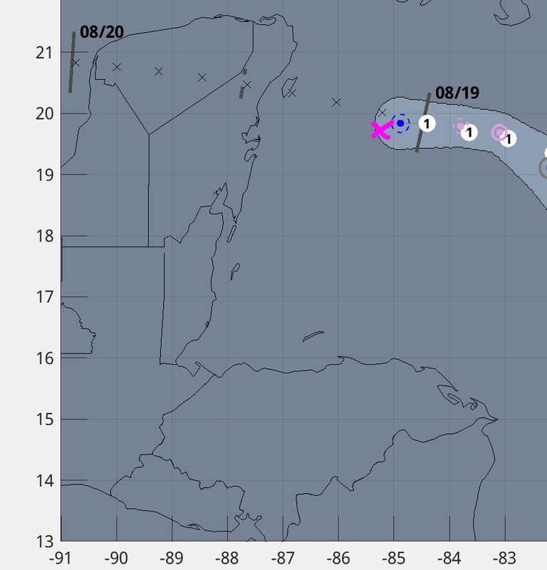
ATL: GRACE - Remnants - Discussion

Moderator: S2k Moderators

Message
Author
User avatar
cycloneye
Admin
Admin
Posts: 145303
Age: 68
Joined: Thu Oct 10, 2002 10:54 am
Location: San Juan, Puerto Rico

Re: ATL: GRACE - Hurricane - Discussion

#1181 Postby cycloneye » Wed Aug 18, 2021 7:41 pm

A. 07L (GRACE)

B. 18/2330Z

C. 19.9N

D. 84.8W

E. ONE/GOES-E

F. T4.5/4.5

G. IR/EIR/VIS

H. REMARKS...OW EYE SURROUNDED BY MG AND EMBEDDED IN DG RESULTS IN A
DT OF 4.5. THE MET AGREES WITH 4.5 BASED ON A DEVELOPING TREND OVER THE
PAST 24 HOURS. THE PT IS ALSO 4.5. FT IS BASED ON DT.

I. ADDL POSITIONS

NIL


...COVERDALE
0 likes   
Visit the Caribbean-Central America Weather Thread where you can find at first post web cams,radars
and observations from Caribbean basin members Click Here

User avatar
aspen
Category 5
Category 5
Posts: 8818
Joined: Sat Oct 12, 2019 7:10 pm
Location: Connecticut, USA

Re: ATL: GRACE - Hurricane - Discussion

#1182 Postby aspen » Wed Aug 18, 2021 7:52 pm

Such a tiny core with such a prominent outer band. If this system had multiple days over open water, this would probably lead to an EWRC, but crossing over the Yucatán should pretty much reset Grace’s structure.

The newest eyewall dropsonde of 988mb/3kt supports a central pressure of 988 or 987 mb. Peak SFMR winds remain at 70 kt.
1 likes   
Irene '11 Sandy '12 Hermine '16 5/15/2018 Derecho Fay '20 Isaias '20 Elsa '21 Henri '21 Ida '21

I am only a meteorology enthusiast who knows a decent amount about tropical cyclones. Look to the professional mets, the NHC, or your local weather office for the best information.

User avatar
Iceresistance
Category 5
Category 5
Posts: 9288
Age: 21
Joined: Sat Oct 10, 2020 9:45 am
Location: Tecumseh, OK/Norman, OK

Re: ATL: GRACE - Hurricane - Discussion

#1183 Postby Iceresistance » Wed Aug 18, 2021 7:53 pm

aspen wrote:Such a tiny core with such a prominent outer band. If this system had multiple days over open water, this would probably lead to an EWRC, but crossing over the Yucatán should pretty much reset Grace’s structure.

The newest eyewall dropsonde of 988mb/3kt supports a central pressure of 988 or 987 mb. Peak SFMR winds remain at 70 kt.


You beat me to it . . . :lol:
1 likes   
Bill 2015 & Beta 2020

Winter 2020-2021 :cold:

All observations are in Tecumseh, OK unless otherwise noted.

Winter posts are focused mainly for Oklahoma & Texas.

Take any of my forecasts with a grain of salt, refer to the NWS, SPC, and NHC for official information

Never say Never with weather! Because ANYTHING is possible!

tolakram
Admin
Admin
Posts: 20009
Age: 62
Joined: Sun Aug 27, 2006 8:23 pm
Location: Florence, KY (name is Mark)

Re: ATL: GRACE - Hurricane - Discussion

#1184 Postby tolakram » Wed Aug 18, 2021 8:04 pm

Grace is still lopsided, with very low winds in the SE side. While it appears to be slowly strengthening I don't think it will get much stronger unless something significant changes.

Image
3 likes   
M a r k
- - - - -
Join us in chat: Storm2K Chatroom Invite. Android and IOS apps also available.

The posts in this forum are NOT official forecasts and should not be used as such. Posts are NOT endorsed by any professional institution or STORM2K.org. For official information and forecasts, please refer to NHC and NWS products.

tolakram
Admin
Admin
Posts: 20009
Age: 62
Joined: Sun Aug 27, 2006 8:23 pm
Location: Florence, KY (name is Mark)

Re: ATL: GRACE - Hurricane - Discussion

#1185 Postby tolakram » Wed Aug 18, 2021 8:13 pm

saved loop
Image
4 likes   
M a r k
- - - - -
Join us in chat: Storm2K Chatroom Invite. Android and IOS apps also available.

The posts in this forum are NOT official forecasts and should not be used as such. Posts are NOT endorsed by any professional institution or STORM2K.org. For official information and forecasts, please refer to NHC and NWS products.

User avatar
aspen
Category 5
Category 5
Posts: 8818
Joined: Sat Oct 12, 2019 7:10 pm
Location: Connecticut, USA

Re: ATL: GRACE - Hurricane - Discussion

#1186 Postby aspen » Wed Aug 18, 2021 8:21 pm

Based on what we’ve seen today, Grace will likely peak as a Cat 1 before landfall in the Yucatán, but that could result in a better structure once it reaches the Gulf. The terrain Grace will be going over isn’t very high, and it’ll only be for 12 hours. That might be enough to “reset” its structure without completely tearing it apart. If Grace ends up with a better structure in the 12 hours after entering the BoC, the higher intensity forecasts are on the table. If Grace ends up with a worse structure, the lower intensities will likely verify instead.
1 likes   
Irene '11 Sandy '12 Hermine '16 5/15/2018 Derecho Fay '20 Isaias '20 Elsa '21 Henri '21 Ida '21

I am only a meteorology enthusiast who knows a decent amount about tropical cyclones. Look to the professional mets, the NHC, or your local weather office for the best information.

TallyTracker
Category 2
Category 2
Posts: 734
Joined: Thu Oct 11, 2018 2:46 pm

Re: ATL: GRACE - Hurricane - Discussion

#1187 Postby TallyTracker » Wed Aug 18, 2021 8:25 pm

That dry air is really keeping a lid on Grace! Doubt the storm will exceed 90 mph with this structure and continued dry air intrusions. The last few frames show it trying to mix out the dry air, but I don’t think it’s going to have time to intensify significantly.

Also, with such a small core, I wonder if the Yucatán will cause greater disruption and result in Grace struggling to strengthen in the BOC.
0 likes   
Fran '96, Georges '98, Gordon '00, Gabrielle '01, Charley '04, Frances '04, Jeanne '04, Barry '07, Fay '08, Debby '12, Matthew '16, Emily '17, Irma '17, Michael ‘18, Elsa ‘21, Fred ‘21, Mindy ‘21, Nicole ‘22, Idalia ‘23, Debby ‘24, Helene ‘24

User avatar
Teban54
Category 5
Category 5
Posts: 3204
Joined: Sat May 19, 2018 1:19 pm

Re: ATL: GRACE - Hurricane - Discussion

#1188 Postby Teban54 » Wed Aug 18, 2021 8:31 pm

The next system that tracks into Western Caribbean will likely have a better chance at RIing and avoiding dry air intrusions than Grace did, as conditions continue to improve into peak season. Unfortunately it seems that there will be a next system given the ridge forecasts.

Reminds me of Nana last year followed by all the infamous late season Caribbean storms, even though Grace is more organized than Nana.
Last edited by Teban54 on Wed Aug 18, 2021 8:44 pm, edited 1 time in total.
1 likes   

User avatar
Yellow Evan
Professional-Met
Professional-Met
Posts: 16143
Age: 27
Joined: Fri Jul 15, 2011 12:48 pm
Location: Henderson, Nevada/Honolulu, HI
Contact:

Re: ATL: GRACE - Hurricane - Discussion

#1189 Postby Yellow Evan » Wed Aug 18, 2021 8:32 pm

Image
2 likes   

hipshot
Category 2
Category 2
Posts: 591
Joined: Tue Jul 06, 2010 9:18 pm
Location: Dallas, Texas

Re: ATL: GRACE - Hurricane - Discussion

#1190 Postby hipshot » Wed Aug 18, 2021 8:32 pm

TallyTracker wrote:That dry air is really keeping a lid on Grace! Doubt the storm will exceed 90 mph with this structure and continued dry air intrusions. The last few frames show it trying to mix out the dry air, but I don’t think it’s going to have time to intensify significantly.

Also, with such a small core, I wonder if the Yucatán will cause greater disruption and result in Grace struggling to strengthen in the BOC.

From what I have read here, a smaller, compact storm will be less impacted by land intervention, especially if it is the far eastern corner of the
Yucatan which I have heard is pretty flat.
0 likes   

User avatar
Iceresistance
Category 5
Category 5
Posts: 9288
Age: 21
Joined: Sat Oct 10, 2020 9:45 am
Location: Tecumseh, OK/Norman, OK

Re: ATL: GRACE - Hurricane - Discussion

#1191 Postby Iceresistance » Wed Aug 18, 2021 8:37 pm

AF304 records 75 knot FL winds in the SW Quadrant, remember that it was only between 30-40 knots only this morning! :eek:
2 likes   
Bill 2015 & Beta 2020

Winter 2020-2021 :cold:

All observations are in Tecumseh, OK unless otherwise noted.

Winter posts are focused mainly for Oklahoma & Texas.

Take any of my forecasts with a grain of salt, refer to the NWS, SPC, and NHC for official information

Never say Never with weather! Because ANYTHING is possible!

User avatar
Hammy
Category 5
Category 5
Posts: 5849
Age: 41
Joined: Fri May 25, 2012 5:25 pm
Contact:

Re: ATL: GRACE - Hurricane - Discussion

#1192 Postby Hammy » Wed Aug 18, 2021 8:45 pm

Image

Eyewall broken to the south after being more closed earlier.
0 likes   
The above post is not official and should not be used as such. It is the opinion of the poster and may or may not be backed by sound meteorological data. It is not endorsed by any professional institution or storm2k.org. For official information, please refer to the NHC and NWS products.

User avatar
cycloneye
Admin
Admin
Posts: 145303
Age: 68
Joined: Thu Oct 10, 2002 10:54 am
Location: San Juan, Puerto Rico

Re: ATL: GRACE - Hurricane - Discussion

#1193 Postby cycloneye » Wed Aug 18, 2021 8:48 pm

VDM says eye open to the south and is 20 miles large. What is this?

CTR DROPSONDE LST WND REPORTED 04005KT AT 33 METERS
1 likes   
Visit the Caribbean-Central America Weather Thread where you can find at first post web cams,radars
and observations from Caribbean basin members Click Here

User avatar
GCANE
S2K Supporter
S2K Supporter
Posts: 11496
Joined: Mon Oct 22, 2007 8:03 am

Re: ATL: GRACE - Hurricane - Discussion

#1194 Postby GCANE » Wed Aug 18, 2021 8:52 pm

IR showing the eyewall hot tower obscuring the eye.
Continues to strengthen from this perspective.
Should see this reflected in measured pressure and wind speeds a bit later.
0 likes   

User avatar
GCANE
S2K Supporter
S2K Supporter
Posts: 11496
Joined: Mon Oct 22, 2007 8:03 am

Re: ATL: GRACE - Hurricane - Discussion

#1195 Postby GCANE » Wed Aug 18, 2021 8:56 pm

Latest recon fix has it south of the forecast track

Image
0 likes   

MarioProtVI
Category 4
Category 4
Posts: 935
Age: 24
Joined: Sun Sep 29, 2019 7:33 pm
Location: New Jersey

Re: ATL: GRACE - Hurricane - Discussion

#1196 Postby MarioProtVI » Wed Aug 18, 2021 9:01 pm

aspen wrote:Based on what we’ve seen today, Grace will likely peak as a Cat 1 before landfall in the Yucatán, but that could result in a better structure once it reaches the Gulf. The terrain Grace will be going over isn’t very high, and it’ll only be for 12 hours. That might be enough to “reset” its structure without completely tearing it apart. If Grace ends up with a better structure in the 12 hours after entering the BoC, the higher intensity forecasts are on the table. If Grace ends up with a worse structure, the lower intensities will likely verify instead.

I think it could be similar to how Karl 2010 played out. When it first formed it was a large and sprawling system, but then shrunk and compacted itself into a small storm ~65 mph before making landfall in the flat area of the Yucatan, then once it got to the BoC it exploded into a high-end C3 (or low-end C4 if you ask me IMO it got really close and was forecasted to at one point).

So far and what worries me is Grace is following this type of trend, with the central core tightening up into a small area while shedding the larger outer bands. If Grace’s structure here remains intact and doesn’t get mangled, all bets could be off once it’s in the BoC and it very easily shoot up towards C2-3 before making landfall in mainland Mexico.
4 likes   

User avatar
ElectricStorm
Category 5
Category 5
Posts: 5044
Age: 24
Joined: Tue Aug 13, 2019 11:23 pm
Location: Skiatook, OK / Norman, OK

Re: ATL: GRACE - Hurricane - Discussion

#1197 Postby ElectricStorm » Wed Aug 18, 2021 9:10 pm

Personally I see her peaking in the gulf but we'll have to see how it looks when it emerges back over water. Looks like my 90kt Yucatan landfall will bust but that's a good thing.
0 likes   
B.S Meteorology, University of Oklahoma '25

Please refer to the NHC, NWS, or SPC for official information.

User avatar
GCANE
S2K Supporter
S2K Supporter
Posts: 11496
Joined: Mon Oct 22, 2007 8:03 am

Re: ATL: GRACE - Hurricane - Discussion

#1198 Postby GCANE » Wed Aug 18, 2021 9:10 pm

Eye is ingesting higher values of CAPE now.
Latest drop shows air saturated from water to 850mb
0 likes   

User avatar
GCANE
S2K Supporter
S2K Supporter
Posts: 11496
Joined: Mon Oct 22, 2007 8:03 am

Re: ATL: GRACE - Hurricane - Discussion

#1199 Postby GCANE » Wed Aug 18, 2021 9:11 pm

Looks like this will have more time over the Yucatan.
0 likes   

User avatar
GCANE
S2K Supporter
S2K Supporter
Posts: 11496
Joined: Mon Oct 22, 2007 8:03 am

Re: ATL: GRACE - Hurricane - Discussion

#1200 Postby GCANE » Wed Aug 18, 2021 9:13 pm

Looks like this will sit in a high Theta-E ridge until landfall.
2 likes   


Return to “2021”

Who is online

Users browsing this forum: No registered users and 10 guests