That is a faster drop than I expected
ATL: GRACE - Remnants - Discussion
Moderator: S2k Moderators
-
cheezyWXguy

- Category 5

- Posts: 6282
- Joined: Mon Feb 13, 2006 12:29 am
- Location: Dallas, TX

Re: ATL: GRACE - Tropical Storm - Discussion
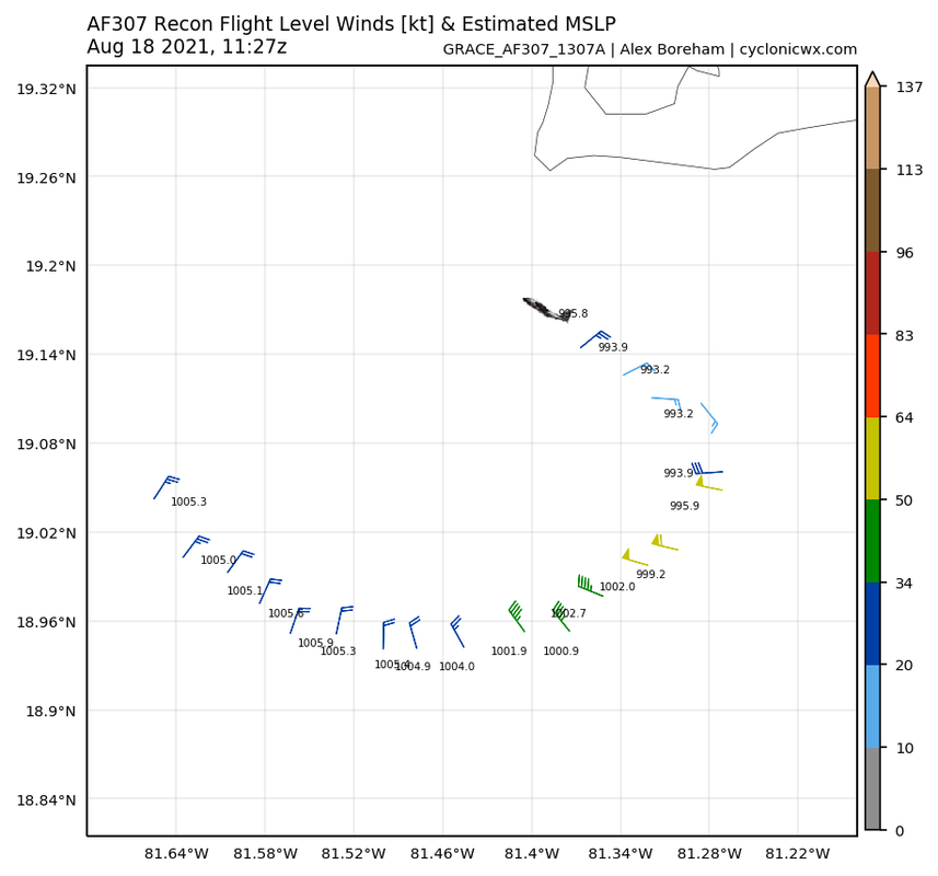
Looks like we may have spoken a bit too soon, guess the plane wasn't at the center yet. Just measured 993 mbar. Could be an indication that HMON is closer to short-term reality than HWRF. HWRF doesn't have this reaching hurricane strength until about 20 hours from now (keeps it at 1000 - 1005 mbar for now), while HMON has it within a few hours. For reference, HWRF has a cat 1 Yucatan landfall and HMON a cat 3.
0 likes


Re: ATL: GRACE - Tropical Storm - Discussion
Lots of subsidence in that PVS.
Seeing very low CAPE.
Appears that it was trying to form convection along a dry-line front but got washed out.
Seeing very low CAPE.
Appears that it was trying to form convection along a dry-line front but got washed out.
1 likes

Re: ATL: GRACE - Tropical Storm - Discussion
Yeah looks like the first plane missed the exact center, or the pressure discrepancy is due to an altitude difference.
I wonder why the PVS is as stubborn as Linda. I’m guessing this is what the HWRF sees that keeps a lid on Grace prior to its Yucatán landfall.
I wonder why the PVS is as stubborn as Linda. I’m guessing this is what the HWRF sees that keeps a lid on Grace prior to its Yucatán landfall.
0 likes
Irene '11 Sandy '12 Hermine '16 5/15/2018 Derecho Fay '20 Isaias '20 Elsa '21 Henri '21 Ida '21
I am only a meteorology enthusiast who knows a decent amount about tropical cyclones. Look to the professional mets, the NHC, or your local weather office for the best information.
I am only a meteorology enthusiast who knows a decent amount about tropical cyclones. Look to the professional mets, the NHC, or your local weather office for the best information.

Re: ATL: GRACE - Tropical Storm - Discussion
NXStumpy_Robothing wrote:
Looks like there has been some strengthening overnight, if these surface measurements are to be believed. Also, recon missed the center to the west, so pressure is probably a little lower than indicated on this first pass.
Another weather station had 57 mph winds and a pressure of 999mb. Interestingly they also had a spike in solar radiation which is a bit weird unless they was am eye but it was 6am.
https://www.wunderground.com/dashboard/pws/IBODDE1
Another station had the same pressure and 50 mph winds, no solar radiation spike.
https://www.wunderground.com/dashboard/pws/IGEORG45
1 likes
-
tolakram
- Admin

- Posts: 20186
- Age: 62
- Joined: Sun Aug 27, 2006 8:23 pm
- Location: Florence, KY (name is Mark)
Re: ATL: GRACE - Tropical Storm - Discussion
Floater visible loop
https://weather.cod.edu/satrad/?parms=meso-meso1-02-24-0-100-1&checked=map&colorbar=undefined
https://weather.cod.edu/satrad/?parms=meso-meso1-02-24-0-100-1&checked=map&colorbar=undefined
0 likes
M a r k
- - - - -
Join us in chat: Storm2K Chatroom Invite. Android and IOS apps also available.
The posts in this forum are NOT official forecasts and should not be used as such. Posts are NOT endorsed by any professional institution or STORM2K.org. For official information and forecasts, please refer to NHC and NWS products.
Re: ATL: GRACE - Tropical Storm - Discussion
Looks like down to about 993mb.
Very tight wind field and warm core.
Very tight wind field and warm core.
3 likes


Re: ATL: GRACE - Tropical Storm - Discussion
Will be interesting to see what wind speeds recon finds in a NE to SW pass.
Last edited by kevin on Wed Aug 18, 2021 6:45 am, edited 1 time in total.
0 likes
-
ElectricStorm

- Category 5
- Posts: 5148
- Age: 25
- Joined: Tue Aug 13, 2019 11:23 pm
- Location: Norman, OK
Re: ATL: GRACE - Tropical Storm - Discussion
Nice to see the PVS stronger this morning as that's probably gonna hold it back and prevent it from becoming a major before the Yucatan. Should still be a solid Cat 1/2 coming in though but luckily it shouldn't explode. Although it's still the WCAR so a major wouldn't surprise me much. Might blow up in the BOC though but we'll have to see what it looks like when it gets back over water.
Last edited by ElectricStorm on Wed Aug 18, 2021 6:50 am, edited 1 time in total.
1 likes
B.S Meteorology, University of Oklahoma '25
Please refer to the NHC, NWS, or SPC for official information.
Please refer to the NHC, NWS, or SPC for official information.
Re: ATL: GRACE - Tropical Storm - Discussion
NOAA3 reported a 80+ mm/hr rain rate right where an eyewall would be.
Due to the fact Grace is so compact, the PVS may not have a great influence on this.
Grace seems to be able to pull heat out of the water at very close distances from the CoC.
Due to the fact Grace is so compact, the PVS may not have a great influence on this.
Grace seems to be able to pull heat out of the water at very close distances from the CoC.
4 likes
Re: ATL: GRACE - Tropical Storm - Discussion
It has that cirrus stacking pattern on VIS Sat with some radial fingers.
Being a small TC, it may take off.
Being a small TC, it may take off.
2 likes
Re: ATL: GRACE - Tropical Storm - Discussion
I would guess that Grace just started strengthening in the past couple hours. That microwave image from a couple hours ago showed that she was very lopsided to the east and was having trouble wrapping bands through the west quadrant into the south quad. On satellite/IR imagery she appears to have started wrapping convection into her west quad more efficiently recently, so if she maintains I would expect more significant pressure drops to start.
How fast she can build a core will probably be the deciding factor in how strong of a TC the Yucatán receives. If she was moving slower she would have more time to really ramp up over the WCar waters.
How fast she can build a core will probably be the deciding factor in how strong of a TC the Yucatán receives. If she was moving slower she would have more time to really ramp up over the WCar waters.
0 likes
Solar Aquarian
Lunar Cancerian
 Sagittarian
Lunar Cancerian
Re: ATL: GRACE - Tropical Storm - Discussion
Do we have any word or obs from the Cayman Islands?
0 likes
Andrew (1992), Irene (1999), Frances (2004), Katrina (2005), Wilma (2005), Fay (2008), Irma (2017), Eta (2020), Ian (2022)
-
ElectricStorm
- Category 5
- Posts: 5148
- Age: 25
- Joined: Tue Aug 13, 2019 11:23 pm
- Location: Norman, OK
Re: ATL: GRACE - Tropical Storm - Discussion
I will say though the last few frames of IR have been looking much more ominous...
0 likes
B.S Meteorology, University of Oklahoma '25
Please refer to the NHC, NWS, or SPC for official information.
Please refer to the NHC, NWS, or SPC for official information.
Re: ATL: GRACE - Tropical Storm - Discussion
...GRACE NEAR GRAND CAYMAN...
...HEAVY RAINS AND STRONG WINDS CONTINUING ACROSS THE CAYMAN
ISLANDS...
SUMMARY OF 800 AM EDT...1200 UTC...INFORMATION
----------------------------------------------
LOCATION...19.1N 81.4W
ABOUT 20 MI...30 KM SW OF GRAND CAYMAN
ABOUT 405 MI...650 KM ESE OF TULUM MEXICO
MAXIMUM SUSTAINED WINDS...65 MPH...100 KM/H
PRESENT MOVEMENT...WNW OR 285 DEGREES AT 16 MPH...26 KM/H
MINIMUM CENTRAL PRESSURE...993 MB...29.32 INCHES
Looks like they went with 993/65
1 likes
-
ElectricStorm
- Category 5
- Posts: 5148
- Age: 25
- Joined: Tue Aug 13, 2019 11:23 pm
- Location: Norman, OK
Re: ATL: GRACE - Tropical Storm - Discussion
BULLETIN
Tropical Storm Grace Intermediate Advisory Number 20A
NWS National Hurricane Center Miami FL AL072021
800 AM EDT Wed Aug 18 2021
...GRACE NEAR GRAND CAYMAN...
...HEAVY RAINS AND STRONG WINDS CONTINUING ACROSS THE CAYMAN
ISLANDS...
SUMMARY OF 800 AM EDT...1200 UTC...INFORMATION
----------------------------------------------
LOCATION...19.1N 81.4W
ABOUT 20 MI...30 KM SW OF GRAND CAYMAN
ABOUT 405 MI...650 KM ESE OF TULUM MEXICO
MAXIMUM SUSTAINED WINDS...65 MPH...100 KM/H
PRESENT MOVEMENT...WNW OR 285 DEGREES AT 16 MPH...26 KM/H
MINIMUM CENTRAL PRESSURE...993 MB...29.32 INCHES
0 likes
B.S Meteorology, University of Oklahoma '25
Please refer to the NHC, NWS, or SPC for official information.
Please refer to the NHC, NWS, or SPC for official information.
-
tolakram
- Admin
- Posts: 20186
- Age: 62
- Joined: Sun Aug 27, 2006 8:23 pm
- Location: Florence, KY (name is Mark)
Re: ATL: GRACE - Tropical Storm - Discussion
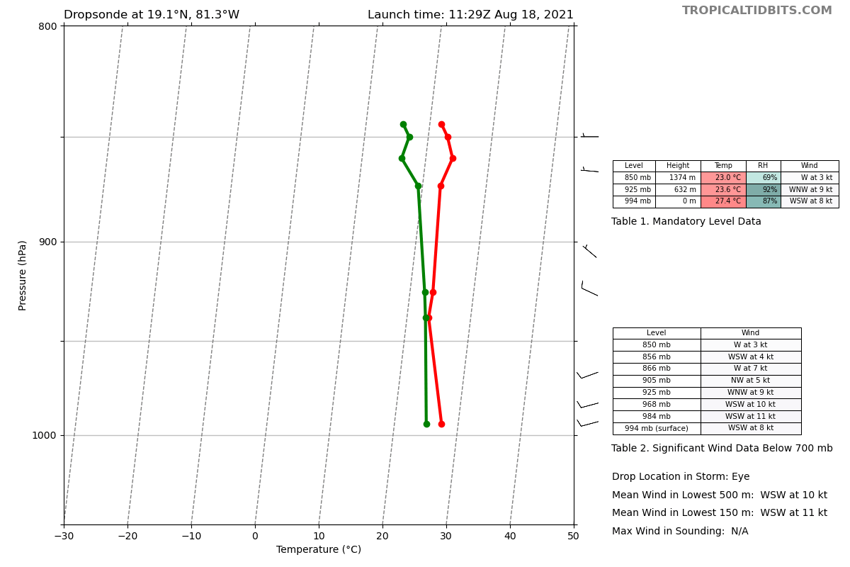
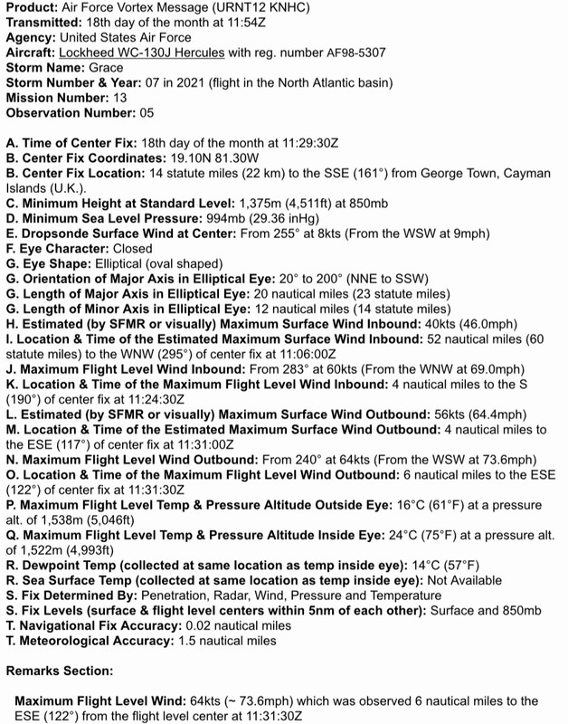
Non decoded, which I find easier to read (but I appreciate the decoded version!)
989
URNT12 KNHC 181154
VORTEX DATA MESSAGE AL072021
A. 18/11:29:30Z
B. 19.10 deg N 081.30 deg W
C. 850 mb 1375 m
D. 994 mb
E. 255 deg 8 kt
F. CLOSED
G. E02/20/12
H. 40 kt
I. 295 deg 52 nm 11:06:00Z
J. 283 deg 60 kt
K. 190 deg 4 nm 11:24:30Z
L. 56 kt
M. 117 deg 4 nm 11:31:00Z
N. 240 deg 64 kt
O. 122 deg 6 nm 11:31:30Z
P. 16 C / 1538 m
Q. 24 C / 1522 m
R. 14 C / NA
S. 12345 / 08
T. 0.02 / 1.5 nm
U. AF307 1307A GRACE OB 05
MAX FL WIND 64 KT 122 / 6 NM 11:31:30Z
1 likes
M a r k
- - - - -
Join us in chat: Storm2K Chatroom Invite. Android and IOS apps also available.
The posts in this forum are NOT official forecasts and should not be used as such. Posts are NOT endorsed by any professional institution or STORM2K.org. For official information and forecasts, please refer to NHC and NWS products.
- - - - -
Join us in chat: Storm2K Chatroom Invite. Android and IOS apps also available.
The posts in this forum are NOT official forecasts and should not be used as such. Posts are NOT endorsed by any professional institution or STORM2K.org. For official information and forecasts, please refer to NHC and NWS products.
Who is online
Users browsing this forum: No registered users and 37 guests