CPAC: LINDA - Post-Tropical

Moderator: S2k Moderators

Message
Author
User avatar
Yellow Evan
Professional-Met
Professional-Met
Posts: 16143
Age: 27
Joined: Fri Jul 15, 2011 12:48 pm
Location: Henderson, Nevada/Honolulu, HI
Contact:

Re: EPAC: LINDA - Hurricane

#401 Postby Yellow Evan » Tue Aug 17, 2021 11:31 pm

ScottNAtlanta wrote:Hawaii is lucky there are cooler waters to the east. If they were not there hurricanes would be a frequent problem every year


As the tropics warm, this shield is becoming less prevalent. Really only exists in -PMM years at this point.
2 likes   

User avatar
Kingarabian
S2K Supporter
S2K Supporter
Posts: 15979
Joined: Sat Aug 08, 2009 3:06 am
Location: Honolulu, Hawaii

Re: EPAC: LINDA - Hurricane

#402 Postby Kingarabian » Wed Aug 18, 2021 12:07 am

00z GFS shifted south closer to Hawaii but still clears Hawaii comfortably.
00z UKMET shifted a good amount to the north but not as north as the GFS. Backs off from a Hawaii hit.
00z CMC shifted south of Hawaii Island.
0 likes   
RIP Kobe Bryant

User avatar
Kingarabian
S2K Supporter
S2K Supporter
Posts: 15979
Joined: Sat Aug 08, 2009 3:06 am
Location: Honolulu, Hawaii

Re: EPAC: LINDA - Hurricane

#403 Postby Kingarabian » Wed Aug 18, 2021 12:13 am

Current Intensity Analysis


UW - CIMSS
ADVANCED DVORAK TECHNIQUE
ADT-Version 9.0
Tropical Cyclone Intensity Algorithm

----- Current Analysis -----
Date : 18 AUG 2021 Time : 042031 UTC
Lat : 17:51:36 N Lon : 129:45:35 W


CI# /Pressure/ Vmax
5.4 / 962.2mb/ 99.6kt


Final T# Adj T# Raw T#
5.3 5.7 5.7

Estimated radius of max. wind based on IR : 33 km

Center Temp : +18.2C Cloud Region Temp : -59.8C

Scene Type : EYE

Subtropical Adjustment : OFF

Extratropical Adjustment : OFF

Positioning Method : ARCHER POSITIONING

Ocean Basin : EAST PACIFIC
Dvorak CI > MSLP Conversion Used : CKZ Method

Tno/CI Rules : Constraint Limits : NO LIMIT
Weakening Flag : ON
Rapid Dissipation Flag : OFF


Image
0 likes   
RIP Kobe Bryant

User avatar
Kingarabian
S2K Supporter
S2K Supporter
Posts: 15979
Joined: Sat Aug 08, 2009 3:06 am
Location: Honolulu, Hawaii

Re: EPAC: LINDA - Hurricane

#404 Postby Kingarabian » Wed Aug 18, 2021 1:52 am

Shrinking but cloud tops are getting colder.
Image

Image
0 likes   
RIP Kobe Bryant

Astromanía
Category 2
Category 2
Posts: 779
Age: 26
Joined: Sat Aug 25, 2018 10:34 pm
Location: Monterrey, N.L, México

Re: EPAC: LINDA - Hurricane

#405 Postby Astromanía » Wed Aug 18, 2021 2:11 am

This storm never stop to impress
4 likes   

User avatar
cycloneye
Admin
Admin
Posts: 145286
Age: 68
Joined: Thu Oct 10, 2002 10:54 am
Location: San Juan, Puerto Rico

Re: EPAC: LINDA - Hurricane

#406 Postby cycloneye » Wed Aug 18, 2021 3:59 am

Hurricane Linda Discussion Number 33
NWS National Hurricane Center Miami FL EP122021
1100 PM HST Tue Aug 17 2021

This evening's satellite presentation indicates that Linda's cloud
pattern hasn't changed much during the past 6 hours. The cyclone
has maintained its impressive annular structure, and the cloud tops
in the southern semicircle of the eyewall have cooled (-72 to -74C)
a little again. The various subjective and objective satellite
intensity estimates haven't changed from the previous 6-hour
classifications, and a blend of these data yields an initial
intensity of 90 kt for this advisory.

Gradual weakening should commence soon as the donut-shaped hurricane
begins moving over sub-25C water within the next 12-24 hours. The
GFS model soundings just downstream of Linda show some modest
westerly shear below 250 mb that could undercut the outflow a bit,
which would contribute to a more evident weakening trend. With that
in mind, the official forecast calls for Linda to finally weaken to
a tropical storm Thursday Night. Although oceanic temperatures
begin to increase again north of the Hawaiian Islands, an increase
in southwesterly shear should prevent regeneration of organized
convection and, therefore, Linda is forecast to become a
post-tropical gale by Friday night. The NHC intensity forecast is
basically an update of the previous one and is still in best
agreement with a blend of the statistical GFS SHIPS and the smart
HCCA multi-model intensity guidance.

The initial motion is estimated to be westward, or 280/11 kt. There
is no significant change to the previous forecast track or
reasoning. A well-established subtropical ridge should steer Linda
in a westward to west-northwestward fashion during the next 5 days.
The new NHC forecast track is essentially just an extension of the
previous one and is based primarily on a blend of the TVCN and HCCA
consensus track guidance. Linda should be crossing into the Central
Pacific by 48 hours, and is expected to pass to the north of the
Hawaiian Islands as a post-tropical gale late in the weekend.


FORECAST POSITIONS AND MAX WINDS

INIT 18/0900Z 18.1N 130.7W 90 KT 105 MPH
12H 18/1800Z 18.5N 132.4W 85 KT 100 MPH
24H 19/0600Z 19.4N 135.3W 80 KT 90 MPH
36H 19/1800Z 20.2N 138.4W 70 KT 80 MPH
48H 20/0600Z 20.8N 141.4W 60 KT 70 MPH
60H 20/1800Z 21.2N 144.3W 50 KT 60 MPH
72H 21/0600Z 21.6N 146.8W 40 KT 45 MPH...POST-TROPICAL
96H 22/0600Z 22.5N 151.4W 35 KT 40 MPH...POST-TROPICAL
120H 23/0600Z 23.3N 156.0W 35 KT 40 MPH...POST-TROPICAL

$$
Forecaster Roberts
0 likes   
Visit the Caribbean-Central America Weather Thread where you can find at first post web cams,radars
and observations from Caribbean basin members Click Here

User avatar
Yellow Evan
Professional-Met
Professional-Met
Posts: 16143
Age: 27
Joined: Fri Jul 15, 2011 12:48 pm
Location: Henderson, Nevada/Honolulu, HI
Contact:

Re: EPAC: LINDA - Hurricane

#407 Postby Yellow Evan » Wed Aug 18, 2021 6:09 am

Been having an off and on B ring. Might be a major now.
0 likes   

User avatar
Yellow Evan
Professional-Met
Professional-Met
Posts: 16143
Age: 27
Joined: Fri Jul 15, 2011 12:48 pm
Location: Henderson, Nevada/Honolulu, HI
Contact:

Re: EPAC: LINDA - Hurricane

#408 Postby Yellow Evan » Wed Aug 18, 2021 6:47 am

Image
1 likes   

User avatar
abajan
S2K Supporter
S2K Supporter
Posts: 4230
Joined: Sun Sep 07, 2003 5:10 am
Location: Barbados

Re: EPAC: LINDA - Hurricane

#409 Postby abajan » Wed Aug 18, 2021 7:27 am

Excerpt from 11 am HST advisory:
STUBBORN LINDA REFUSES TO WEAKEN
3 likes   

User avatar
Yellow Evan
Professional-Met
Professional-Met
Posts: 16143
Age: 27
Joined: Fri Jul 15, 2011 12:48 pm
Location: Henderson, Nevada/Honolulu, HI
Contact:

Re: EPAC: LINDA - Hurricane

#410 Postby Yellow Evan » Wed Aug 18, 2021 7:28 am

TXPZ23 KNES 181215
TCSENP

A. 12E (LINDA)

B. 18/1130Z

C. 18.1N

D. 131.2W

E. ONE/GOES-W

F. T5.0/5.5

G. IR/EIR/SWIR

H. REMARKS...SYSTEM HAS A WMG EYE TEMP AND IS SURROUNDED IN A LG RING
TEMP ALLOWING AN EYE ADJUSTMENT OF 0.5 AND IS EMBEDDED IN MG RESULTING
IN AN EYE PATTERN DT OF 5.0. THE 24 HR TREND IS DEVELOPING SLOWLY. MET
IS 4.5 AND PT IS 5.0. FT IS BASED ON DT.

I. ADDL POSITIONS

NIL


...PATEL
0 likes   

User avatar
Kingarabian
S2K Supporter
S2K Supporter
Posts: 15979
Joined: Sat Aug 08, 2009 3:06 am
Location: Honolulu, Hawaii

Re: EPAC: LINDA - Hurricane

#411 Postby Kingarabian » Wed Aug 18, 2021 8:33 am

The blend supports a major IMO. But NHC not budging off 90kts.

UW - CIMSS
ADVANCED DVORAK TECHNIQUE
ADT-Version 9.0
Tropical Cyclone Intensity Algorithm

----- Current Analysis -----
Date : 18 AUG 2021 Time : 125032 UTC
Lat : 18:08:59 N Lon : 131:24:36 W


CI# /Pressure/ Vmax
5.8 / 952.7mb/109.8kt


Final T# Adj T# Raw T#
5.8 5.7 5.7

Estimated radius of max. wind based on IR : 32 km

Center Temp : +17.2C Cloud Region Temp : -59.5C

Scene Type : EYE

Subtropical Adjustment : OFF

Extratropical Adjustment : OFF

Positioning Method : ARCHER POSITIONING

Ocean Basin : EAST PACIFIC
Dvorak CI > MSLP Conversion Used : CKZ Method

Tno/CI Rules : Constraint Limits : NO LIMIT
Weakening Flag : OFF
Rapid Dissipation Flag : OFF

C/K/Z MSLP Estimate Inputs :
- Average 34 knot radii : 72nmi
- Environmental MSLP : 1011mb

Satellite Name : GOES17
Satellite Viewing Angle : 22.3 degrees
0 likes   
RIP Kobe Bryant

tolakram
Admin
Admin
Posts: 20009
Age: 62
Joined: Sun Aug 27, 2006 8:23 pm
Location: Florence, KY (name is Mark)

Re: EPAC: LINDA - Hurricane

#412 Postby tolakram » Wed Aug 18, 2021 8:59 am

saved loop

Image
4 likes   
M a r k
- - - - -
Join us in chat: Storm2K Chatroom Invite. Android and IOS apps also available.

The posts in this forum are NOT official forecasts and should not be used as such. Posts are NOT endorsed by any professional institution or STORM2K.org. For official information and forecasts, please refer to NHC and NWS products.

tolakram
Admin
Admin
Posts: 20009
Age: 62
Joined: Sun Aug 27, 2006 8:23 pm
Location: Florence, KY (name is Mark)

Re: EPAC: LINDA - Hurricane

#413 Postby tolakram » Wed Aug 18, 2021 9:04 am

This is from yesterday evening

Image
3 likes   
M a r k
- - - - -
Join us in chat: Storm2K Chatroom Invite. Android and IOS apps also available.

The posts in this forum are NOT official forecasts and should not be used as such. Posts are NOT endorsed by any professional institution or STORM2K.org. For official information and forecasts, please refer to NHC and NWS products.

User avatar
cycloneye
Admin
Admin
Posts: 145286
Age: 68
Joined: Thu Oct 10, 2002 10:54 am
Location: San Juan, Puerto Rico

Re: EPAC: LINDA - Hurricane

#414 Postby cycloneye » Wed Aug 18, 2021 9:59 am

Hurricane Linda Discussion Number 34
NWS National Hurricane Center Miami FL EP122021
500 AM HST Wed Aug 18 2021

Satellite images indicate that Linda has been maintaining its
intensity over the past 12 h or so. The hurricane has begun to
lose some of its annular characteristics, as cloud tops in the
northern semicircle are warmer than in the southern semicircle.
However, the eye remains clear, and the overall structure has not
changed much in the last 6 h. Final-T numbers from TAFB and SAB
were both T-5.0/90 kt. Therefore, the initial intensity remains 90
kt for this advisory.

Linda is currently over SSTs near 26C, but SSTs along the path of
the cyclone will decrease to below 25C in about 12 h, then remain
in the 24-25C range during the 12 to 48 h period. Vertical wind
shear will remain low through 48 h, but mid-level relative humidity
will decrease and become very dry over the next 48 h. Despite the
favorable dynamics through 48 h, the unfavorable thermodynamics
will likely cause weakening to below hurricane strength by 48 h. By
72 h, wind shear is forecast to increase and become strong by day 4
as Linda approaches a potent upper-level trough located to the
northwest of Oahu. This will ultimately lead to the loss of deep
convection, despite a slight increase in water temperatures along
the cyclone's path at that time. Linda is forecast to become a
post-tropical gale by Saturday morning. The NHC intensity forecast
is essentially unchanged from the previous forecast and is in best
agreement with the DSHP statistical-dynamical guidance.

The initial motion is 280/11, which is unchanged from 6 h ago.
There is no significant change to the previous forecast track or
reasoning. A well-established subtropical ridge should steer Linda
in a westward to west-northwestward fashion during the next 5 days.
The new NHC forecast track is virtually unchanged from the previous
one and is in best agreement with the TVCN and HCCA consensus
models. Linda is forecast to cross into the Central Pacific in
about 36 h and is expected to pass to the north of the Hawaiian
Islands as a post-tropical gale late Sunday into Monday.


FORECAST POSITIONS AND MAX WINDS

INIT 18/1500Z 18.2N 131.8W 90 KT 105 MPH
12H 19/0000Z 18.9N 133.9W 85 KT 100 MPH
24H 19/1200Z 19.7N 136.9W 75 KT 85 MPH
36H 20/0000Z 20.3N 140.0W 65 KT 75 MPH
48H 20/1200Z 20.8N 142.9W 55 KT 65 MPH
60H 21/0000Z 21.2N 145.6W 45 KT 50 MPH
72H 21/1200Z 21.6N 148.0W 40 KT 45 MPH...POST-TROPICAL
96H 22/1200Z 22.6N 152.5W 35 KT 40 MPH...POST-TROPICAL
120H 23/1200Z 23.5N 157.3W 35 KT 40 MPH...POST-TROPICAL

$$
Forecaster Hagen/Cangialosi
0 likes   
Visit the Caribbean-Central America Weather Thread where you can find at first post web cams,radars
and observations from Caribbean basin members Click Here

User avatar
Kingarabian
S2K Supporter
S2K Supporter
Posts: 15979
Joined: Sat Aug 08, 2009 3:06 am
Location: Honolulu, Hawaii

Re: EPAC: LINDA - Hurricane

#415 Postby Kingarabian » Wed Aug 18, 2021 1:50 pm

Looks like it has peaked. Increasingly shallow now.
0 likes   
RIP Kobe Bryant

User avatar
Yellow Evan
Professional-Met
Professional-Met
Posts: 16143
Age: 27
Joined: Fri Jul 15, 2011 12:48 pm
Location: Henderson, Nevada/Honolulu, HI
Contact:

Re: EPAC: LINDA - Hurricane

#416 Postby Yellow Evan » Wed Aug 18, 2021 1:51 pm

TXPZ23 KNES 181815
TCSENP

A. 12E (LINDA)

B. 18/1730Z

C. 18.4N

D. 132.4W

E. ONE/GOES-W

F. T4.5/5.0

G. IR/EIR/VIS

H. REMARKS...SYSTEM HAS A WMG EYE SURROUNDED BY AND EMBEDDED IN MG
RESULTING IN AN EYE PATTERN DT OF 4.5. SYSTEM IS DEGRADING IN PERSISTENT
ACTIVE DEEP CONVECTION ON SATELLITE IMAGERY IN THE SW QUADRANT OF THE
EYEWALL. THE 24 HR TREND IS WEAKENING SLOWLY. MET AND PT ARE 4.5. FT IS
BASED ON DT.

I. ADDL POSITIONS

NIL


...PATEL
0 likes   

User avatar
Kingarabian
S2K Supporter
S2K Supporter
Posts: 15979
Joined: Sat Aug 08, 2009 3:06 am
Location: Honolulu, Hawaii

Re: EPAC: LINDA - Hurricane

#417 Postby Kingarabian » Wed Aug 18, 2021 2:52 pm

Image
0 likes   
RIP Kobe Bryant

User avatar
Kingarabian
S2K Supporter
S2K Supporter
Posts: 15979
Joined: Sat Aug 08, 2009 3:06 am
Location: Honolulu, Hawaii

Re: EPAC: LINDA - Hurricane

#418 Postby Kingarabian » Wed Aug 18, 2021 3:30 pm

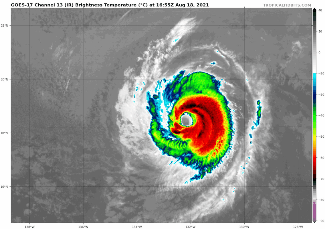
In regards to a Hawaii impact, still looks like nothing more than a weak TS and that's IF Linda can remain intact during its trek over very cold waters.

Good amount of EPS and GEFS members point towards Hawaii.
Image
Image

12z CMC continues to be the most southern model, pushing Linda into the Alenuihaha Channel.
12z Icon shows some sort of hit.
12z UKMET shifts back south a little closer to Oahu but still clears the island.
12z Euro also shifted back south and probably has a north Kauai landfall.

GFS/HWRF/HMON continue to clear Hawaii comfortably to the north. But the HWRF and HMON find a way to restrengthen this to 45-50kts @ the surface, and comfortable 60-70kt hurricane force gusts while being well north of Hawaii. Wonder how their forecasts would look if they shifted closer to Hawaii. Probably enough to make Maui or Oahu sweat a direct impact.

Image
Image
0 likes   
RIP Kobe Bryant

User avatar
cycloneye
Admin
Admin
Posts: 145286
Age: 68
Joined: Thu Oct 10, 2002 10:54 am
Location: San Juan, Puerto Rico

Re: EPAC: LINDA - Hurricane

#419 Postby cycloneye » Wed Aug 18, 2021 3:38 pm

Hurricane Linda Discussion Number 35
NWS National Hurricane Center Miami FL EP122021
1100 AM HST Wed Aug 18 2021

Since the time of the previous advisory, satellite images show that
Linda's cloud tops have warmed and are less prevalent on its west
side. Visible imagery has also shown an increase in the low-level
cloud cover inside the eye, though Linda still displays a fairly
well-defined eye in infrared imagery. Dvorak T-numbers from TAFB and
SAB have decreased, and the initial intensity has been lowered to 85
kt for this advisory.

Linda is currently over SSTs near 26 C, but SSTs along the path of
the cyclone will decrease to below 25 C in about 6 hours, then
remain in the 24-25 C range between 6 to 48 hours. Vertical wind
shear will remain low through 48 h, then steadily increase during
the day 3 to 5 period as Linda approaches a potent upper-level
trough located to the northwest of Oahu. Perhaps even more
detrimental than the gradually increasing wind shear is the dry
airmass that Linda is embedded in, with environmental mid-level
relative humidity values of less than 40 percent. Mid-level moisture
is forecast to decrease further over the next 48 hours. A
combination of these environmental factors will ultimately lead to
the loss of deep convection, and Linda is forecast to become a
post-tropical gale by Saturday. Although the intensity forecast
reasoning has not changed appreciably, a slightly faster weakening
rate is forecast through the first 36 hours. However, the new NHC
intensity forecast still lies at the high end of the guidance during
that time. Beyond 36 h, little change has been made to the previous
forecast.

The initial motion is 285/12 kt. A well-established subtropical
ridge should steer Linda in a westward to west-northwestward fashion
during the next 5 days. There is essentially no change to the
forecast track through 72 hours. Thereafter, a slight southward
nudge was made, but still lies just to the north of the TVCE and
HCCA consensus aids. Linda is forecast to cross into the Central
Pacific in about 30 h and is expected to pass to the north of the
Hawaiian Islands as a post-tropical gale late Sunday into Monday.


FORECAST POSITIONS AND MAX WINDS

INIT 18/2100Z 18.7N 133.2W 85 KT 100 MPH
12H 19/0600Z 19.3N 135.3W 75 KT 85 MPH
24H 19/1800Z 20.0N 138.3W 65 KT 75 MPH
36H 20/0600Z 20.6N 141.4W 55 KT 65 MPH
48H 20/1800Z 21.0N 144.2W 50 KT 60 MPH
60H 21/0600Z 21.3N 146.7W 45 KT 50 MPH
72H 21/1800Z 21.8N 149.0W 40 KT 45 MPH...POST-TROPICAL
96H 22/1800Z 22.7N 153.5W 35 KT 40 MPH...POST-TROPICAL
120H 23/1800Z 23.4N 158.5W 30 KT 35 MPH...POST-TROPICAL

$$
Forecaster Hagen/Papin/Cangialosi
0 likes   
Visit the Caribbean-Central America Weather Thread where you can find at first post web cams,radars
and observations from Caribbean basin members Click Here

Sciencerocks
Category 5
Category 5
Posts: 9155
Age: 39
Joined: Thu Jul 06, 2017 1:51 am

Re: EPAC: LINDA - Hurricane

#420 Postby Sciencerocks » Wed Aug 18, 2021 3:43 pm

Image
0 likes   


Return to “2021”

Who is online

Users browsing this forum: No registered users and 4 guests