This is a pretty small storm and can wrap up quickly, I would be preparing for the possibility of a major if I lived
on the Yucatan peninsula.
Very hard to forecast intensity in these situations as you could have anything from a Cat 1 if it is only
able to slowing organize to a maybe Cat 3 if able to quickly close off an eye.
ATL: GRACE - Remnants - Discussion
Moderator: S2k Moderators
-
AtlanticWind

- S2K Supporter

- Posts: 1898
- Age: 67
- Joined: Sun Aug 08, 2004 9:57 pm
- Location: Plantation,Fla
-
AtlanticWind
- S2K Supporter
- Posts: 1898
- Age: 67
- Joined: Sun Aug 08, 2004 9:57 pm
- Location: Plantation,Fla
Re: ATL: GRACE - Tropical Storm - Discussion
The 12Z Tuesday run of the SHIPS model gave a 22% chance that Grace would rapidly intensify by 35 mph into an 85-mph category 1 hurricane by 8 a.m. Wednesday, when the storm will be close to Grand Cayman Island. The National Hurricane Center was predicting that Grace would be a 75-mph hurricane at that time. More eye-opening was the model’s prediction that Grace had a 33% chance of intensifying into a 125-mph category 3 hurricane by Friday morning, as it approached its final landfall in Mexico’s Veracruz state on the western Gulf of Mexico. Citing the unknown amount of disruption Grace might encounter while crossing the Yucatan Peninsula, NHC was conservative in its intensity forecast for that time, calling for Grace to be a minimal category 1 hurricane with 75 mph winds.
From Jeff Masters earlier. Dont know if anyone had posted this but thought it was interesting.
From Jeff Masters earlier. Dont know if anyone had posted this but thought it was interesting.
0 likes
-
ElectricStorm

- Category 5

- Posts: 5148
- Age: 25
- Joined: Tue Aug 13, 2019 11:23 pm
- Location: Norman, OK
Re: ATL: GRACE - Tropical Storm - Discussion
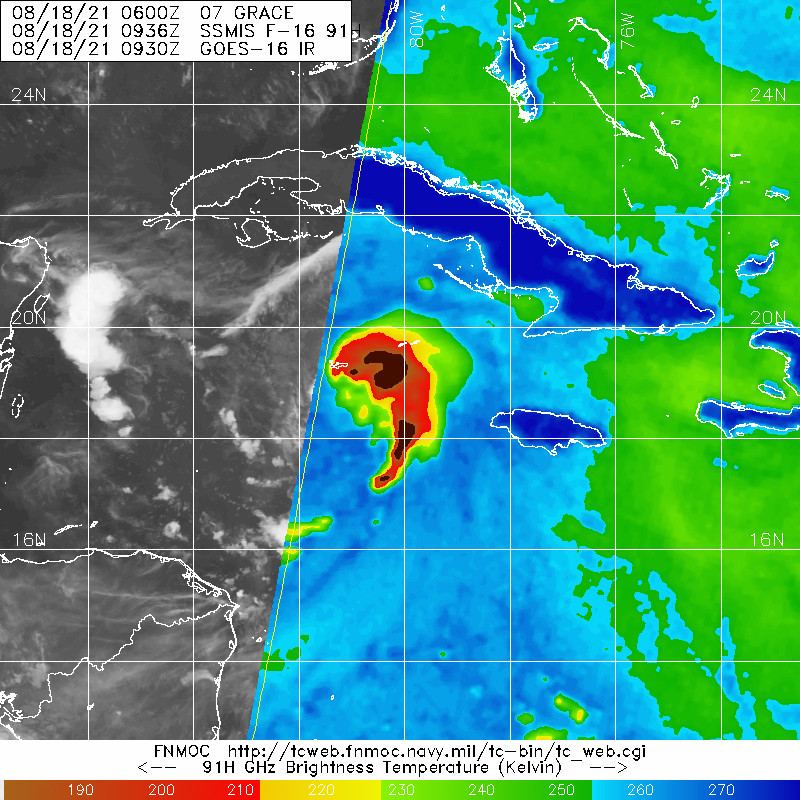
It appears the previous eye drop was a bit off as the newest one supports a pressure of 1001mb so the pressure hasn't quite began to fall yet. I'd imagine that will change soon.
0 likes
B.S Meteorology, University of Oklahoma '25
Please refer to the NHC, NWS, or SPC for official information.
Please refer to the NHC, NWS, or SPC for official information.

Re: ATL: GRACE - Tropical Storm - Discussion
This storm finally has a really credible COC. Grace might actually begin to take on a much more classical hurricane appearance tomorrow. A significantly stronger system might suggest it could gain a tad bit greater latitude prior to reaching Yucatan. I just wonder under what circumstances might this still remain a threat to Brownsville?
1 likes
Andy D
(For official information, please refer to the NHC and NWS products.)
(For official information, please refer to the NHC and NWS products.)
-
Sciencerocks
- Category 5
- Posts: 10186
- Age: 40
- Joined: Thu Jul 06, 2017 1:51 am


Re: ATL: GRACE - Tropical Storm - Discussion
Looks like Grace is currently near the northern edge of the cone, which might have an impact on its eventual path and duration above land after the Yucatan landfall.
1 likes

Re: ATL: GRACE - Tropical Storm - Discussion
Does look a bit on the northern side to me as well, 18.8N 89.8W IMO
0 likes
Once I see the REDS and GREENS Converge on a Base Velocity. ... I'm There!!
This is NOT an Official Forecast....Just my Opinion. For official information, please refer to the NHC and NWS products.
HIGHLIGHTS : '13 El Reno Tornado : 2013 Storm Chaser Tour, Joaquin; SC flood event, Matthew '16, Lowcountry Snow storm Jan '18
This is NOT an Official Forecast....Just my Opinion. For official information, please refer to the NHC and NWS products.
HIGHLIGHTS : '13 El Reno Tornado : 2013 Storm Chaser Tour, Joaquin; SC flood event, Matthew '16, Lowcountry Snow storm Jan '18
-
Iceresistance

- Category 5
- Posts: 9599
- Age: 22
- Joined: Sat Oct 10, 2020 9:45 am
- Location: Tecumseh, OK/Norman, OK
Re: ATL: GRACE - Tropical Storm - Discussion
She is getting me really nervous now, that southern feeder band is exploding the convection, Super Typhoon Goni in 2020 had a similar structure while undergoing RI while a Tropical Storm . . .

0 likes
Bill 2015 & Beta 2020
Winter 2020-2021
All observations are in Tecumseh, OK unless otherwise noted.
Winter posts are focused mainly for Oklahoma & Texas.
Take any of my forecasts with a grain of salt, refer to the NWS, SPC, and NHC for official information
Never say Never with weather! Because ANYTHING is possible!
Winter 2020-2021
All observations are in Tecumseh, OK unless otherwise noted.
Winter posts are focused mainly for Oklahoma & Texas.
Take any of my forecasts with a grain of salt, refer to the NWS, SPC, and NHC for official information
Never say Never with weather! Because ANYTHING is possible!

Re: ATL: GRACE - Tropical Storm - Discussion
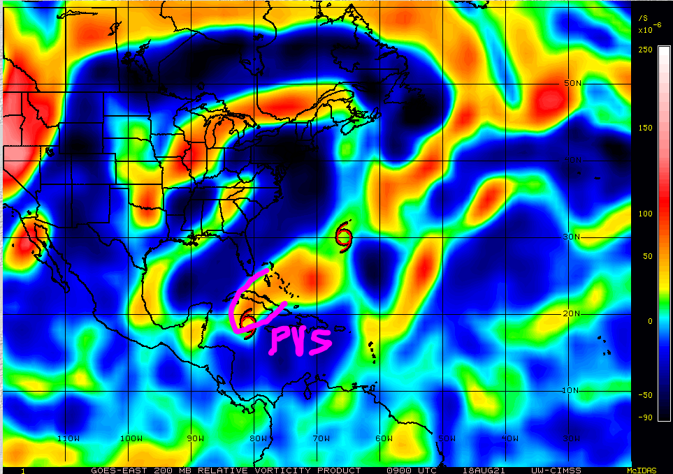
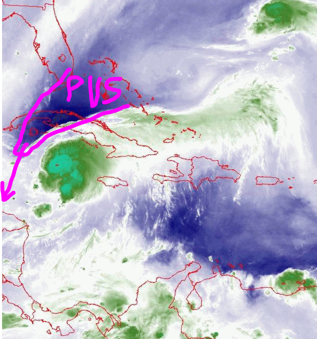
Seems to me that the LLC is displaced a bit and is on the edge of the deep convection, possibly due to the PVS-induced shear. Recon and visible imagery will be able to tell us soon. The HWRF has been rather bearish with intensity in the WCar so maybe it’s on to something, which would be good for the Yucatán; better to have a Cat 1 than a major at landfall.
1 likes
Irene '11 Sandy '12 Hermine '16 5/15/2018 Derecho Fay '20 Isaias '20 Elsa '21 Henri '21 Ida '21
I am only a meteorology enthusiast who knows a decent amount about tropical cyclones. Look to the professional mets, the NHC, or your local weather office for the best information.
I am only a meteorology enthusiast who knows a decent amount about tropical cyclones. Look to the professional mets, the NHC, or your local weather office for the best information.
-
Iceresistance
- Category 5
- Posts: 9599
- Age: 22
- Joined: Sat Oct 10, 2020 9:45 am
- Location: Tecumseh, OK/Norman, OK
Re: ATL: GRACE - Tropical Storm - Discussion
It appears that the NOAA3 Mission into Grace had to be aborted because of a possible sensor failure . . .

The SFMR rain rate & wind speed measurements has appeared to stop working just as they wanted to go in!

The SFMR rain rate & wind speed measurements has appeared to stop working just as they wanted to go in!
0 likes
Bill 2015 & Beta 2020
Winter 2020-2021
All observations are in Tecumseh, OK unless otherwise noted.
Winter posts are focused mainly for Oklahoma & Texas.
Take any of my forecasts with a grain of salt, refer to the NWS, SPC, and NHC for official information
Never say Never with weather! Because ANYTHING is possible!
Winter 2020-2021
All observations are in Tecumseh, OK unless otherwise noted.
Winter posts are focused mainly for Oklahoma & Texas.
Take any of my forecasts with a grain of salt, refer to the NWS, SPC, and NHC for official information
Never say Never with weather! Because ANYTHING is possible!
Re: ATL: GRACE - Tropical Storm - Discussion
Iceresistance wrote:It appears that the NOAA3 Mission into Grace had to be aborted because of a possible sensor failure . . .
https://s5.gifyu.com/images/recon_NOAA3-1207A-GRACE.png
The SFMR rain rate & wind speed measurements has appeared to stop working just as they wanted to go in!
https://s5.gifyu.com/images/recon_NOAA3-1207A-GRACE_timeseries.png
Every time I see a plane make a U-turn on the map I get flashbacks to Eta, that might still be the most chaotic day on the forum since I've joined.
1 likes
Re: ATL: GRACE - Tropical Storm - Discussion
Iceresistance wrote:It appears that the NOAA3 Mission into Grace had to be aborted because of a possible sensor failure . . .
https://s5.gifyu.com/images/recon_NOAA3-1207A-GRACE.png
The SFMR rain rate & wind speed measurements has appeared to stop working just as they wanted to go in!
https://s5.gifyu.com/images/recon_NOAA3-1207A-GRACE_timeseries.png
Nope, they’re fine. They were just heading north for a N to S pass, and are already turning into the circulation.
1 likes
Irene '11 Sandy '12 Hermine '16 5/15/2018 Derecho Fay '20 Isaias '20 Elsa '21 Henri '21 Ida '21
I am only a meteorology enthusiast who knows a decent amount about tropical cyclones. Look to the professional mets, the NHC, or your local weather office for the best information.
I am only a meteorology enthusiast who knows a decent amount about tropical cyclones. Look to the professional mets, the NHC, or your local weather office for the best information.
-
Iceresistance
- Category 5
- Posts: 9599
- Age: 22
- Joined: Sat Oct 10, 2020 9:45 am
- Location: Tecumseh, OK/Norman, OK
Re: ATL: GRACE - Tropical Storm - Discussion
aspen wrote:Iceresistance wrote:It appears that the NOAA3 Mission into Grace had to be aborted because of a possible sensor failure . . .
https://s5.gifyu.com/images/recon_NOAA3-1207A-GRACE.png
The SFMR rain rate & wind speed measurements has appeared to stop working just as they wanted to go in!
https://s5.gifyu.com/images/recon_NOAA3-1207A-GRACE_timeseries.png
Nope, they’re fine. They were just heading north for a N to S pass, and are already turning into the circulation.
And of course, just I say that sensor is having issues, it's working again!

0 likes
Bill 2015 & Beta 2020
Winter 2020-2021
All observations are in Tecumseh, OK unless otherwise noted.
Winter posts are focused mainly for Oklahoma & Texas.
Take any of my forecasts with a grain of salt, refer to the NWS, SPC, and NHC for official information
Never say Never with weather! Because ANYTHING is possible!
Winter 2020-2021
All observations are in Tecumseh, OK unless otherwise noted.
Winter posts are focused mainly for Oklahoma & Texas.
Take any of my forecasts with a grain of salt, refer to the NWS, SPC, and NHC for official information
Never say Never with weather! Because ANYTHING is possible!
-
tolakram
- Admin

- Posts: 20186
- Age: 62
- Joined: Sun Aug 27, 2006 8:23 pm
- Location: Florence, KY (name is Mark)
Re: ATL: GRACE - Tropical Storm - Discussion
AF allowed to fly over Cuba. Or they snuck across. 
1 likes
M a r k
- - - - -
Join us in chat: Storm2K Chatroom Invite. Android and IOS apps also available.
The posts in this forum are NOT official forecasts and should not be used as such. Posts are NOT endorsed by any professional institution or STORM2K.org. For official information and forecasts, please refer to NHC and NWS products.
Re: ATL: GRACE - Tropical Storm - Discussion
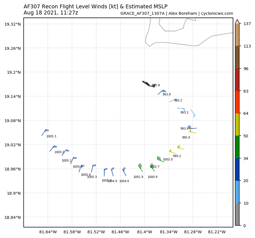
Looks to be around 999-1000 mbar, so it’s not intensifying quickly at all despite the nuclear grade SSTs. Or they might’ve missed the exact center.
1 likes
Irene '11 Sandy '12 Hermine '16 5/15/2018 Derecho Fay '20 Isaias '20 Elsa '21 Henri '21 Ida '21
I am only a meteorology enthusiast who knows a decent amount about tropical cyclones. Look to the professional mets, the NHC, or your local weather office for the best information.
I am only a meteorology enthusiast who knows a decent amount about tropical cyclones. Look to the professional mets, the NHC, or your local weather office for the best information.


Re: ATL: GRACE - Tropical Storm - Discussion
Based on the deepening convection last night, I thought that PVS would be taken out.
This morning, it appears the opposite. Looks like it is strengthening.
This will put a lid on any strengthening of Grace in the near term.
This morning, it appears the opposite. Looks like it is strengthening.
This will put a lid on any strengthening of Grace in the near term.
0 likes
-
HurricaneEnzo

- Category 2

- Posts: 744
- Joined: Wed Mar 14, 2018 12:18 pm
- Location: Newport, NC (Hurricane Alley)
Re: ATL: GRACE - Tropical Storm - Discussion
aspen wrote:Looks to be around 999-1000 mbar, so it’s not intensifying quickly at all despite the nuclear grade SSTs. Or they might’ve missed the exact center.
Yeah looks like it hasn't strengthened a whole lot 'yet'. Looking like it may be putting itself in a position for more rapid intensification as we go through the day though. But who knows every time I think a storm is about to take off if falls flat on its face in a few hours
0 likes
Bertha 96' - Fran 96' - Bonnie 98' - Dennis 99' - Floyd 99' - Isabel 03' - Alex 04' - Ophelia 05' - Irene 11' - Arthur 14' - Matthew 16' - Florence 18' - Dorian 19' - Isaias 20' (countless other tropical storms and Hurricane swipes)
I am not a Professional Met just an enthusiast. Get your weather forecasts from the Pros!
I am not a Professional Met just an enthusiast. Get your weather forecasts from the Pros!
-
NXStumpy_Robothing
- Category 1

- Posts: 335
- Age: 25
- Joined: Fri Jun 05, 2020 11:50 pm
- Location: North Georgia
Re: ATL: GRACE - Tropical Storm - Discussion
https://twitter.com/AWxNYC/status/1427952684473126921
Looks like there has been some strengthening overnight, if these surface measurements are to be believed. Also, recon missed the center to the west, so pressure is probably a little lower than indicated on this first pass.
Looks like there has been some strengthening overnight, if these surface measurements are to be believed. Also, recon missed the center to the west, so pressure is probably a little lower than indicated on this first pass.
0 likes
Undergraduate Meteorology Student, Georgia Institute of Technology
Who is online
Users browsing this forum: No registered users and 13 guests