
Good thing there is a 355K PV streamer ahead of this that is putting a lid on any strong spin up.
Looks like that will clear out once Grace gets close to the Yucatan.
ATL: GRACE - Remnants - Discussion
Moderator: S2k Moderators
-
lrak

- S2K Supporter

- Posts: 1770
- Age: 59
- Joined: Thu Jun 21, 2007 2:48 pm
- Location: Corpus Christi, TX
Re: ATL: GRACE - Tropical Depression - Discussion
Reading prior posts "weak means west" if Grace does gain strength before the Yucatan will it move closer to Texas?
0 likes
AKA karl
Also
Personal Forecast Disclaimer:
My posts on this forum are NOT official forecast and should not be used as such. My posts are my basic observations and are definitely not backed by any "well some" meteorological knowledge. For official information, please refer to the NHC and NWS products.
Also
Personal Forecast Disclaimer:
My posts on this forum are NOT official forecast and should not be used as such. My posts are my basic observations and are definitely not backed by any "well some" meteorological knowledge. For official information, please refer to the NHC and NWS products.
-
vbhoutex

- Storm2k Executive

- Posts: 29149
- Age: 74
- Joined: Wed Oct 09, 2002 11:31 pm
- Location: Cypress, TX
- Contact:
Re: ATL: GRACE - Tropical Depression - Discussion
lrak wrote:Reading prior posts "weak means west" if Grace does gain strength before the Yucatan will it move closer to Texas?
Imo it is a possibility but with Fred heading inland today the ridge should be building in behind him and this would tend to keep Grace on a more southerly track. If Grace somehow intensifies unexpectedly there would be the possibility she could erode the West side of the ridge some which could lead to a more northerly track.
3 likes
Skywarn, C.E.R.T.
Please click below to donate to STORM2K to help with the expenses of keeping the site going:

Please click below to donate to STORM2K to help with the expenses of keeping the site going:
Re: ATL: GRACE - Tropical Depression - Discussion
vbhoutex wrote:lrak wrote:Reading prior posts "weak means west" if Grace does gain strength before the Yucatan will it move closer to Texas?
Imo it is a possibility but with Fred heading inland today the ridge should be building in behind him and this would tend to keep Grace on a more southerly track. If Grace somehow intensifies unexpectedly there would be the possibility she could erode the West side of the ridge some which could lead to a more northerly track.
Good morning!...I noticed the 11 am NHC Grace update has the intensity at 70 mph, at 96 hours, I found that to be interesting, perhaps the center remaining over water, versus over the land areas of the DR, and unfortunately Haiti, and the earthquake affected areas..does this 96 hour intensity leave the NHC more wiggle room for perhaps a system with higher intensity than us thought at this time?....I hope that my question makes sense, lol...but I'm curious if the experts feel that Grace may pack a bit more punch than what it appears to be at the moment?
0 likes
Re: ATL: GRACE - Tropical Depression - Discussion
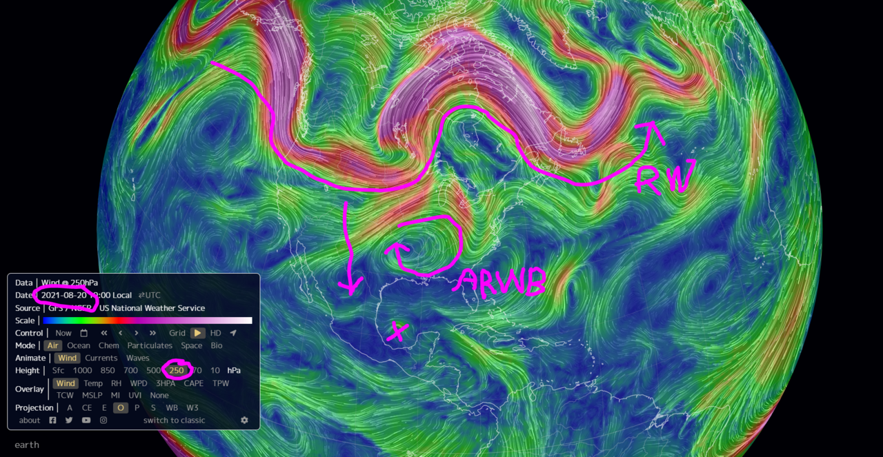
Taking a quick look at the synoptic forecast, particularly 355K PV and CAPE.
Looks like this could ramp up in the BOC/GOM.
Looks like this could ramp up in the BOC/GOM.
1 likes
Re: ATL: GRACE - Tropical Depression - Discussion
Keeping a close eye on the forecast around the 21st when this gets in the GOM.
The Rossby Wave is very significant.
If it pushes more south or becomes a bit delayed in the upcoming forecasts, the ARWB would then follow and get more over Grace.
Also, if Graces' forecasted track moves more north, the same thing.
The idea is if Grace gets under the ARWB, then rapid intensification becomes a real possibility.
4 likes
-
Sciencerocks
- Category 5

- Posts: 10186
- Age: 40
- Joined: Thu Jul 06, 2017 1:51 am


Re: ATL: GRACE - Tropical Depression - Discussion
Recon just found ~45 kt FL and ~50 kt SFMR winds, heavily suggesting Grace is back to being a TS. The center is getting very close to the southernmost tip of DR and might be shifting north for a landfall.
2 likes
Irene '11 Sandy '12 Hermine '16 5/15/2018 Derecho Fay '20 Isaias '20 Elsa '21 Henri '21 Ida '21
I am only a meteorology enthusiast who knows a decent amount about tropical cyclones. Look to the professional mets, the NHC, or your local weather office for the best information.
I am only a meteorology enthusiast who knows a decent amount about tropical cyclones. Look to the professional mets, the NHC, or your local weather office for the best information.
-
Category5Kaiju

- Category 5
- Posts: 4339
- Joined: Thu Dec 24, 2020 12:45 pm
- Location: Seattle during the summer, Phoenix during the winter
Re: ATL: GRACE - Tropical Depression - Discussion
It really breaks my heart that the region of Haiti devastated by the 7.2 earthquake is now bracing for even more suffering from the rain from Grace. I had really hoped that Grace would miss Haiti entirely in light of that disaster, but unfortunately it looks like that may not come to fruition. Almost reminds me of when in 1991 Mt. Pinatubo's eruption happened and then a typhoon impacted the affected region shortly afterwards
7 likes
Unless explicitly stated, all information in my posts is based on my own opinions and observations. Tropical storms and hurricanes can be extremely dangerous. Refer to an accredited weather research agency or meteorologist if you need to make serious decisions regarding an approaching storm.


Re: ATL: GRACE - Tropical Depression - Discussion
aspen wrote:Recon just found ~45 kt FL and ~50 kt SFMR winds, heavily suggesting Grace is back to being a TS. The center is getting very close to the southernmost tip of DR and might be shifting north for a landfall.
If the center were to shift north, how would that affect the track?
0 likes
Re: ATL: GRACE - Tropical Depression - Discussion
Sambucol wrote:aspen wrote:Recon just found ~45 kt FL and ~50 kt SFMR winds, heavily suggesting Grace is back to being a TS. The center is getting very close to the southernmost tip of DR and might be shifting north for a landfall.
If the center were to shift north, how would that affect the track?
It could go between Cuba and the Yucatán into the Gulf, as seen in the 12z HWRF, which initialized Grace very well. Without a landfall in the Yucatán, Grace could have a higher ceiling in the Gulf because it won’t have to rebuild a core.
2 likes
Irene '11 Sandy '12 Hermine '16 5/15/2018 Derecho Fay '20 Isaias '20 Elsa '21 Henri '21 Ida '21
I am only a meteorology enthusiast who knows a decent amount about tropical cyclones. Look to the professional mets, the NHC, or your local weather office for the best information.
I am only a meteorology enthusiast who knows a decent amount about tropical cyclones. Look to the professional mets, the NHC, or your local weather office for the best information.
-
jaguars_22
- Category 2

- Posts: 629
- Joined: Tue Jun 20, 2017 2:26 pm
- Location: Victoria TX
Re: ATL: GRACE - Tropical Depression - Discussion
It looks to me like grace is getting that shape? She looks better on IR
0 likes
Re: ATL: GRACE - Tropical Depression - Discussion
I’m surprised Grace remains a TD despite data from recon supporting winds greater than 30 kt. Since she’s producing a lot more convection that could translate FL winds down to the surface, maybe she’s upgraded at 5pm.
Looks like Grace could become a very potent threat in the Gulf. Most models are suggesting a hurricane in the BoC, and the HWRF goes absolutely bonkers with a 921 mbar Cat 4 near landfall, partially due to the center missing the Yucatán.
Looks like Grace could become a very potent threat in the Gulf. Most models are suggesting a hurricane in the BoC, and the HWRF goes absolutely bonkers with a 921 mbar Cat 4 near landfall, partially due to the center missing the Yucatán.
0 likes
Irene '11 Sandy '12 Hermine '16 5/15/2018 Derecho Fay '20 Isaias '20 Elsa '21 Henri '21 Ida '21
I am only a meteorology enthusiast who knows a decent amount about tropical cyclones. Look to the professional mets, the NHC, or your local weather office for the best information.
I am only a meteorology enthusiast who knows a decent amount about tropical cyclones. Look to the professional mets, the NHC, or your local weather office for the best information.
-
cheezyWXguy

- Category 5
- Posts: 6282
- Joined: Mon Feb 13, 2006 12:29 am
- Location: Dallas, TX
Re: ATL: GRACE - Tropical Depression - Discussion
aspen wrote:I’m surprised Grace remains a TD despite data from recon supporting winds greater than 30 kt. Since she’s producing a lot more convection that could translate FL winds down to the surface, maybe she’s upgraded at 5pm.
Looks like Grace could become a very potent threat in the Gulf. Most models are suggesting a hurricane in the BoC, and the HWRF goes absolutely bonkers with a 921 mbar Cat 4 near landfall, partially due to the center missing the Yucatán.
Agreed, this is a TS. The center is also pretty apparent, you can see the rotating center of convection as it passes the southern tip of hispaniola. The hwrf may not be that far off on short term track
0 likes
Re: ATL: GRACE - Tropical Depression - Discussion
Sciencerocks wrote:https://imagizer.imageshack.com/img922/1247/Wex0iS.gif
Grace appears to be holding its own for now....are there any features that Grace will encounter that may limit it's development...other than land interaction?
0 likes
-
ElectricStorm

- Category 5
- Posts: 5148
- Age: 25
- Joined: Tue Aug 13, 2019 11:23 pm
- Location: Norman, OK
Re: ATL: GRACE - Tropical Depression - Discussion
underthwx wrote:Sciencerocks wrote:https://imagizer.imageshack.com/img922/1247/Wex0iS.gif
Grace appears to be holding its own for now....are there any features that Grace will encounter that may limit it's development...other than land interaction?
NHC mentioned some shear may keep it in check until it reaches the Yucatan. But once it gets into the gulf conditions will likely be very good.
0 likes
B.S Meteorology, University of Oklahoma '25
Please refer to the NHC, NWS, or SPC for official information.
Please refer to the NHC, NWS, or SPC for official information.
Re: ATL: GRACE - Tropical Depression - Discussion
Weather Dude wrote:underthwx wrote:Sciencerocks wrote:https://imagizer.imageshack.com/img922/1247/Wex0iS.gif
Grace appears to be holding its own for now....are there any features that Grace will encounter that may limit it's development...other than land interaction?
NHC mentioned some shear may keep it in check until it reaches the Yucatan. But once it gets into the gulf conditions will likely be very good.
Thanks for your reply..
0 likes
Re: ATL: GRACE - Tropical Depression - Discussion
Weather Dude wrote:underthwx wrote:Sciencerocks wrote:https://imagizer.imageshack.com/img922/1247/Wex0iS.gif
Grace appears to be holding its own for now....are there any features that Grace will encounter that may limit it's development...other than land interaction?
NHC mentioned some shear may keep it in check until it reaches the Yucatan. But once it gets into the gulf conditions will likely be very good.
Looking at the HWRF, it seems that shear finally starts letting up once it nears/passes through the Yucatán Channel late Wednesday/early Thursday, dropping below 20 kt with the flow in all levels of the atmosphere starting to match the same direction. Upon entering the Gulf the next day, shear is under 10 kt.
0 likes
Irene '11 Sandy '12 Hermine '16 5/15/2018 Derecho Fay '20 Isaias '20 Elsa '21 Henri '21 Ida '21
I am only a meteorology enthusiast who knows a decent amount about tropical cyclones. Look to the professional mets, the NHC, or your local weather office for the best information.
I am only a meteorology enthusiast who knows a decent amount about tropical cyclones. Look to the professional mets, the NHC, or your local weather office for the best information.
-
Category5Kaiju
- Category 5
- Posts: 4339
- Joined: Thu Dec 24, 2020 12:45 pm
- Location: Seattle during the summer, Phoenix during the winter
Re: ATL: GRACE - Tropical Depression - Discussion
Cancun may need to watch this closely.
0 likes
Unless explicitly stated, all information in my posts is based on my own opinions and observations. Tropical storms and hurricanes can be extremely dangerous. Refer to an accredited weather research agency or meteorologist if you need to make serious decisions regarding an approaching storm.
-
alienstorm

- Category 1

- Posts: 496
- Joined: Tue Jul 31, 2007 1:29 pm
- Location: Miami Fla western suburb
Re: ATL: GRACE - Tropical Depression - Discussion
Not sure it's my deceiving eyes but looks like Grace center may be riding up the Bahone West coast. If that is the case then could affect more of Haiti and potentially Eastern Cuba.
0 likes
Personal Forecast Disclaimer:The posts in this forum are NOT official forecast and should not be used as such. They are just the opinion of the poster and may or may not be backed by sound meteorological data. They are NOT endorsed by any professional institution or storm2k.org. For official information, please refer to the NHC and NWS products.
Who is online
Users browsing this forum: No registered users and 53 guests