ATL: GRACE - Models

Moderator: S2k Moderators

Message
Author
User avatar
Kohlecane
Category 2
Category 2
Posts: 593
Age: 33
Joined: Sun Jul 31, 2011 11:03 pm
Location: Beaufort, SC

Re: ATL: GRACE - Models

#521 Postby Kohlecane » Sat Aug 14, 2021 7:45 pm

Spacecoast wrote:
Kohlecane wrote:
Blown Away wrote:https://i.imgur.com/fOD5epI.gif
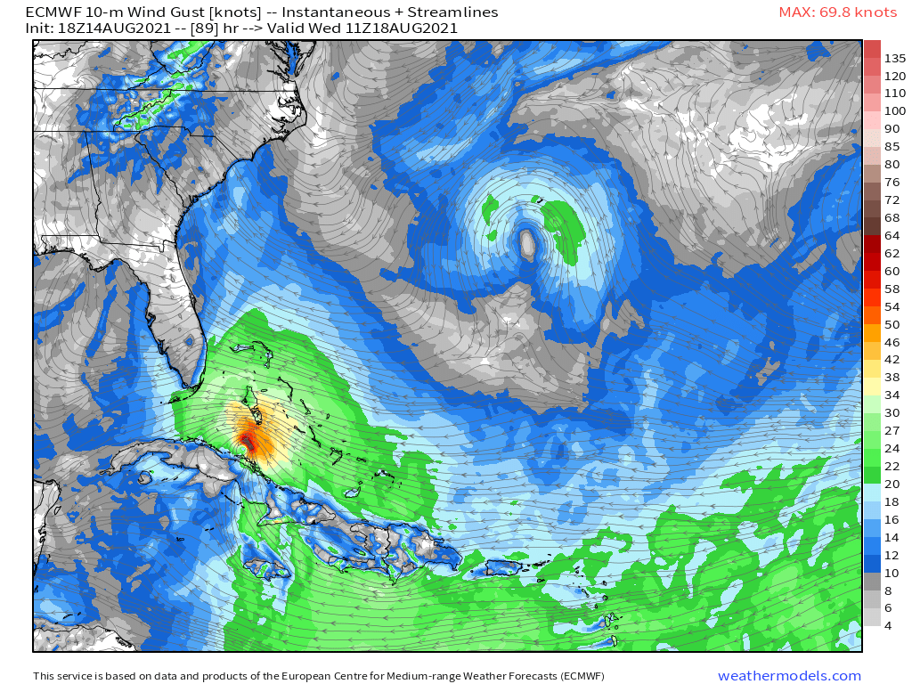
18z HWRF... Big shift N with Cat 2 @105 mph hurricane into Upper Keys...

Could only imagine what we would be looking at if this run went another 48 hours :eek:


HWRF looks remarkably similar to 12z CMC run,which ends up N gulf (Alabama / Mississippi)

Aside from a couple of 12z EMCF ensemble members, the 12z CMC, and 18z HWRF are currently the northernmost tracks.

Interesting to see what the CMC let alone the rest of the 00Z runs show
1 likes   
Once I see the REDS and GREENS Converge on a Base Velocity. ... I'm There!!

This is NOT an Official Forecast....Just my Opinion. For official information, please refer to the NHC and NWS products.
HIGHLIGHTS : '13 El Reno Tornado : 2013 Storm Chaser Tour, Joaquin; SC flood event, Matthew '16, Lowcountry Snow storm Jan '18

Michele B
S2K Supporter
S2K Supporter
Posts: 1114
Joined: Thu Aug 25, 2016 8:08 am
Location: SWFL

Re: ATL: GRACE - Models

#522 Postby Michele B » Sat Aug 14, 2021 7:49 pm

Blown Away wrote:https://i.imgur.com/Tzq1T65.gif
18z HWRF 96 Hours... @3.5 degrees N & @5 degrees E of 12z... Much, much slower... 96 hours appears to find better conditions??


Really??

THAT far north??

IDK
0 likes   
Cleo - 1964, Betsy - 1965, David - 1979, Andrew - 1992, Charlie (Francis, Ivan, Jeanne) - 2004, Irma - 2017, Ian - 2022

User avatar
ScottNAtlanta
Category 5
Category 5
Posts: 2367
Joined: Sat May 25, 2013 3:11 pm
Location: Atlanta, GA

Re: ATL: GRACE - Models

#523 Postby ScottNAtlanta » Sat Aug 14, 2021 7:58 pm

Nothing good comes of a NW heading storm forced west in that area. They almost always bomb out
1 likes   
The posts in this forum are NOT official forecast and should not be used as such. They are just the opinion of the poster and may or may not be backed by sound meteorological data. They are NOT endorsed by any professional institution or storm2k.org. For official information, please refer to the NHC and NWS products.

User avatar
SFLcane
S2K Supporter
S2K Supporter
Posts: 10163
Age: 47
Joined: Sat Jun 05, 2010 1:44 pm
Location: Lake Worth Florida

Re: ATL: GRACE - Models

#524 Postby SFLcane » Sat Aug 14, 2021 7:58 pm

18z eps stronger and north of Haiti.
0 likes   

tolakram
Admin
Admin
Posts: 20009
Age: 62
Joined: Sun Aug 27, 2006 8:23 pm
Location: Florence, KY (name is Mark)

Re: ATL: GRACE - Models

#525 Postby tolakram » Sat Aug 14, 2021 8:07 pm

18Z EPS
Image
0 likes   
M a r k
- - - - -
Join us in chat: Storm2K Chatroom Invite. Android and IOS apps also available.

The posts in this forum are NOT official forecasts and should not be used as such. Posts are NOT endorsed by any professional institution or STORM2K.org. For official information and forecasts, please refer to NHC and NWS products.

User avatar
captainbarbossa19
Professional-Met
Professional-Met
Posts: 1092
Age: 27
Joined: Wed Aug 21, 2019 11:09 pm
Location: Beaumont, TX

Re: ATL: GRACE - Models

#526 Postby captainbarbossa19 » Sat Aug 14, 2021 8:15 pm

tolakram wrote:18Z EPS
https://i.imgur.com/PVFlAOo.gif


Well, we clearly know where Grace is headed now! :D
5 likes   

User avatar
gatorcane
S2K Supporter
S2K Supporter
Posts: 23691
Age: 47
Joined: Sun Mar 13, 2005 3:54 pm
Location: Boca Raton, FL

Re: ATL: GRACE - Models

#527 Postby gatorcane » Sat Aug 14, 2021 8:15 pm

00Z:

Image
Image
0 likes   

LarryWx
S2K Supporter
S2K Supporter
Posts: 6304
Joined: Sun Sep 07, 2003 2:04 pm
Location: GA

Re: ATL: GRACE - Models

#528 Postby LarryWx » Sat Aug 14, 2021 8:19 pm

Although the 18Z GEFS members are overall weaker than many earlier runs, the 18Z Euro ens has a good number of strong members out of its 51 members with it easily the most active run of today.
0 likes   
Personal Forecast Disclaimer:
The posts in this forum are NOT official forecasts and should not be used as such. They are just the opinion of the poster and may or may not be backed by sound meteorological data. They are NOT endorsed by any professional institution or storm2k.org. For official information, please refer to the NHC and NWS products.

AxaltaRacing24
Category 5
Category 5
Posts: 1753
Age: 25
Joined: Wed Jul 27, 2016 11:14 am
Location: Jupiter, FL

Re: ATL: GRACE - Models

#529 Postby AxaltaRacing24 » Sat Aug 14, 2021 8:22 pm

tolakram wrote:18Z EPS
https://i.imgur.com/PVFlAOo.gif

I have no words.
0 likes   

sma10
Category 5
Category 5
Posts: 1710
Joined: Tue Aug 02, 2005 1:13 pm

Re: ATL: GRACE - Models

#530 Postby sma10 » Sat Aug 14, 2021 8:26 pm


18z EPS and HWRF ... Both hinting at the infamous "bend back to the west" troublemaker
5 likes   

AutoPenalti
Category 5
Category 5
Posts: 4030
Age: 29
Joined: Mon Aug 17, 2015 4:16 pm
Location: Ft. Lauderdale, Florida

Re: ATL: GRACE - Models

#531 Postby AutoPenalti » Sat Aug 14, 2021 8:27 pm

I have such a headache right now. I can’t even workout anymore. This has become a sick addiction.
7 likes   
The posts in this forum are NOT official forecasts and should not be used as such. They are just the opinion of the poster and may or may not be backed by sound meteorological data. They are NOT endorsed by any professional institution or STORM2K. For official information, please refer to products from the NHC and NWS.


Model Runs Cheat Sheet:
GFS (5:30 AM/PM, 11:30 AM/PM)
HWRF, GFDL, UKMET, NAVGEM (6:30-8:00 AM/PM, 12:30-2:00 AM/PM)
ECMWF (1:45 AM/PM)

TCVN
is a weighted averaged

User avatar
aspen
Category 5
Category 5
Posts: 8818
Joined: Sat Oct 12, 2019 7:10 pm
Location: Connecticut, USA

Re: ATL: GRACE - Models

#532 Postby aspen » Sat Aug 14, 2021 8:29 pm

tolakram wrote:18Z EPS
https://i.imgur.com/PVFlAOo.gif

Looks like future Henri up there near Bermuda could become something of note.
3 likes   
Irene '11 Sandy '12 Hermine '16 5/15/2018 Derecho Fay '20 Isaias '20 Elsa '21 Henri '21 Ida '21

I am only a meteorology enthusiast who knows a decent amount about tropical cyclones. Look to the professional mets, the NHC, or your local weather office for the best information.

AxaltaRacing24
Category 5
Category 5
Posts: 1753
Age: 25
Joined: Wed Jul 27, 2016 11:14 am
Location: Jupiter, FL

Re: ATL: GRACE - Models

#533 Postby AxaltaRacing24 » Sat Aug 14, 2021 8:29 pm

AutoPenalti wrote:I have such a headache right now. I can’t even workout anymore. This has become a sick addiction.

imagine how the NHC feels.
5 likes   

User avatar
Blown Away
S2K Supporter
S2K Supporter
Posts: 10145
Joined: Wed May 26, 2004 6:17 am

Re: ATL: GRACE - Models

#534 Postby Blown Away » Sat Aug 14, 2021 8:40 pm

tolakram wrote:18Z EPS
https://i.imgur.com/PVFlAOo.gif


Operational buries into Hispaniola & Cuba and nearly all the ensembles into SFL. Still don’t know how to read that.
1 likes   
Hurricane Eye Experience: David 79, Irene 99, Frances 04, Jeanne 04, Wilma 05... EYE COMING MY WAY IN 2024…
Hurricane Brush Experience: Andrew 92, Erin 95, Floyd 99, Matthew 16, Irma 17, Ian 22, Nicole 22…

User avatar
SFLcane
S2K Supporter
S2K Supporter
Posts: 10163
Age: 47
Joined: Sat Jun 05, 2010 1:44 pm
Location: Lake Worth Florida

Re: ATL: GRACE - Models

#535 Postby SFLcane » Sat Aug 14, 2021 8:57 pm

:eek:

Image
0 likes   

User avatar
ElectricStorm
Category 5
Category 5
Posts: 5044
Age: 24
Joined: Tue Aug 13, 2019 11:23 pm
Location: Skiatook, OK / Norman, OK

Re: ATL: GRACE - Models

#536 Postby ElectricStorm » Sat Aug 14, 2021 8:58 pm


Man a few of those go straight for Hispaniola but then yeet north at the last second :double:
1 likes   
B.S Meteorology, University of Oklahoma '25

Please refer to the NHC, NWS, or SPC for official information.

User avatar
blp
Category 5
Category 5
Posts: 2840
Age: 46
Joined: Thu Sep 09, 2004 7:51 pm
Location: Miami, FL
Contact:

Re: ATL: GRACE - Models

#537 Postby blp » Sat Aug 14, 2021 8:59 pm

aspen wrote:
tolakram wrote:18Z EPS
https://i.imgur.com/PVFlAOo.gif

Looks like future Henri up there near Bermuda could become something of note.


Great point. That is a wild card could pull it further north.
0 likes   
The following post is NOT an official forecast and should not be used as such. It is just the opinion of the poster and may or may not be backed by sound meteorological data. It is NOT endorsed by any professional institution including storm2k.org For Official Information please refer to the NHC and NWS products.

User avatar
SFLcane
S2K Supporter
S2K Supporter
Posts: 10163
Age: 47
Joined: Sat Jun 05, 2010 1:44 pm
Location: Lake Worth Florida

Re: ATL: GRACE - Models

#538 Postby SFLcane » Sat Aug 14, 2021 8:59 pm

Blown Away wrote:
tolakram wrote:18Z EPS
https://i.imgur.com/PVFlAOo.gif


Operational buries into Hispaniola & Cuba and nearly all the ensembles into SFL. Still don’t know how to read that.


Euro does not it’s actually intensifying heading wnw here.

Image
0 likes   

AxaltaRacing24
Category 5
Category 5
Posts: 1753
Age: 25
Joined: Wed Jul 27, 2016 11:14 am
Location: Jupiter, FL

Re: ATL: GRACE - Models

#539 Postby AxaltaRacing24 » Sat Aug 14, 2021 9:01 pm

Weather Dude wrote:

Man a few of those go straight for Hispaniola but then yeet north at the last second :double:

They do not need this at all after the earthquake. Keep those shifts coming.
1 likes   

jlauderdal
S2K Supporter
S2K Supporter
Posts: 7182
Joined: Wed May 19, 2004 5:46 am
Location: NE Fort Lauderdale
Contact:

Re: RE: Re: ATL: GRACE - Models

#540 Postby jlauderdal » Sat Aug 14, 2021 9:01 pm

SouthFLTropics wrote:HWRF about to lay the smack down to Key Largo…976mb and deepening.


Sent from my iPhone using Tapatalk
The hwrf has hit se florida twice in a week and will fail both times, that is very sad.
0 likes   


Return to “2021”

Who is online

Users browsing this forum: No registered users and 3 guests