CPAC: LINDA - Post-Tropical

Moderator: S2k Moderators

Message
Author
Shell Mound
Category 5
Category 5
Posts: 2434
Age: 32
Joined: Thu Sep 07, 2017 3:39 pm
Location: St. Petersburg, FL → Scandinavia

Re: EPAC: LINDA - Hurricane

#241 Postby Shell Mound » Sat Aug 14, 2021 6:57 am

Yellow Evan wrote:
Yellow Evan wrote:
Kingarabian wrote:Storms moving WNW typically have 10kts lower wind speeds in the western and southern quadrants compared to the N/NE. So the 110kt estimate from the NHC might not be too bad.

Yes but the winds on Clarion (idk enough about it's location - elevation? is it exposed? how much of a factor would land friction play?) were not impressive either and I derived the above estimates from the eye pressure.

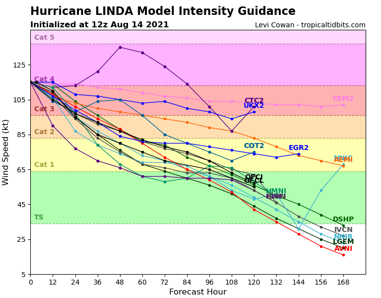
https://i.imgur.com/OElYSgf.jpg
3m in elevation so wind obs might be a little low but pretty exposed.

Despite exposure, prior to the arrival of the eye the station was reporting maximum sustained winds of ~62 kt from the southeast (90°) at 07:00 UTC. After the passage of the eye the MSW was ~77 kt from the southwest (230°) at 09:00 UTC. The latter observation appears to have been accurate, but the direction of the former seems to have been incorrect, given the fact that Linda was just east-southeast of the station at 07:00 UTC. The lowest MSLP registered was 967.2 mb at 08:00 UTC and coincided with winds of ~13 kt, during which the station encountered the southern portion of Linda’s eye. As a rule MSLP tends to decrease by 1 mb per 10 kt inside the RMW, if I recall correctly, so 967.2 mb coincident with ~13 kt would imply a central pressure of ~965 mb. Given that Linda was moving west-northwestward past Clarion Island, the strongest winds would have been centred north-northeast of the eye, and could have been 20 kt higher than the MSW of ~77 kt observed in the southeastern quadrant. So Linda’s actual intensity around the time of its passage over Clarion Island was likely on the order of 95 kt/965 mb.
1 likes   
CVW / MiamiensisWx / Shell Mound
The posts in this forum are NOT official forecasts and should not be used as such. They are just the opinion of the poster and may or may not be backed by sound meteorological data. They are NOT endorsed by any professional institution or STORM2K. For official information, please refer to products from the NHC and NWS.

Subtrop
Category 2
Category 2
Posts: 670
Joined: Sun Feb 21, 2021 9:45 pm

Re: EPAC: LINDA - Hurricane

#242 Postby Subtrop » Sat Aug 14, 2021 7:52 am

EP, 12, 2021081412, , BEST, 0, 186N, 1155W, 115, 950, HU,
0 likes   

User avatar
Yellow Evan
Professional-Met
Professional-Met
Posts: 16143
Age: 27
Joined: Fri Jul 15, 2011 12:48 pm
Location: Henderson, Nevada/Honolulu, HI
Contact:

Re: EPAC: LINDA - Hurricane

#243 Postby Yellow Evan » Sat Aug 14, 2021 9:18 am

TXPZ23 KNES 141226
TCSENP

A. 12E (LINDA)

B. 14/1130Z

C. 18.6N

D. 115.5W

E. ONE/GOES-W

F. T6.0/6.0

G. IR/EIR/SWIR

H. REMARKS...WMG EYE SURROUNDED BY B AND EMBEDDED IN LG RESULTS IN
A E# OF 5.0 AND EADJ OF +1.0. 6 HR AVG GIVES A DT=6.1 SO CONSTRAINTS
BROKEN. MET AND PT=6.0. FT IS BASED ON THE 6 HR AVG DT.

I. ADDL POSITIONS

NIL


...KONON
0 likes   

User avatar
Yellow Evan
Professional-Met
Professional-Met
Posts: 16143
Age: 27
Joined: Fri Jul 15, 2011 12:48 pm
Location: Henderson, Nevada/Honolulu, HI
Contact:

Re: EPAC: LINDA - Hurricane

#244 Postby Yellow Evan » Sat Aug 14, 2021 9:41 am

Image

Absolutely stunning.
9 likes   

User avatar
Stormybajan
Category 1
Category 1
Posts: 448
Joined: Thu May 20, 2021 3:21 pm
Location: Windward Islands

Re: EPAC: LINDA - Hurricane

#245 Postby Stormybajan » Sat Aug 14, 2021 9:43 am


Beautiful Hurricane and Out to sea
0 likes   
Sad West Indies and Manchester United fan ⚽️

User avatar
Iceresistance
Category 5
Category 5
Posts: 9288
Age: 21
Joined: Sat Oct 10, 2020 9:45 am
Location: Tecumseh, OK/Norman, OK

Re: EPAC: LINDA - Hurricane

#246 Postby Iceresistance » Sat Aug 14, 2021 9:43 am

NHC has this as a CAT 4 now

...LINDA AT CATEGORY 4 STRENGTH OVER THE OPEN WATERS OF THE EASTERN NORTH PACIFIC...
8:00 AM PDT Sat Aug 14
Location: 18.8°N 116.1°W
Moving: WNW at 13 mph
Min pressure: 950 mb
Max sustained: 130 mph
1 likes   
Bill 2015 & Beta 2020

Winter 2020-2021 :cold:

All observations are in Tecumseh, OK unless otherwise noted.

Winter posts are focused mainly for Oklahoma & Texas.

Take any of my forecasts with a grain of salt, refer to the NWS, SPC, and NHC for official information

Never say Never with weather! Because ANYTHING is possible!

User avatar
cycloneye
Admin
Admin
Posts: 145303
Age: 68
Joined: Thu Oct 10, 2002 10:54 am
Location: San Juan, Puerto Rico

Re: EPAC: LINDA - Hurricane

#247 Postby cycloneye » Sat Aug 14, 2021 9:46 am

TCDEP2

Hurricane Linda Discussion Number 18
NWS National Hurricane Center Miami FL EP122021
800 AM PDT Sat Aug 14 2021

Linda is maintaining a well-defined 15-n mi wide eye, and a quite
symmetric surrounding convective cloud pattern. Taking a blend of
the latest subjective and objective Dvorak estimates gives a current
intensity estimate of about 115 kt, i.e. category 4 strength.

Linda may undergo an eyewall replacement later today, which is
typical for intense hurricanes, and this could cause some
short-term fluctuations in intensity. The hurricane is currently
in a low-vertical shear environment, and the dynamical guidance
indicates that the shear will remain low for the next few days.
However, SSTs beneath Linda should gradually lower along with
decreasing environmental mid-level humidities during the next
several days. Thus a slow weakening trend should commence by
tonight. The official intensity forecast is a blend of the
corrected and simple model consensus predictions.

The initial motion is estimated to be west-northwestward, or
290/11 kt. There is little change to the expected steering
scenario. Linda is moving along the southern side of a pronounced
subtropical ridge. The ridge is predicted by the global models to
build westward to the northwest of the hurricane during the next
couple of days. This should cause Linda to turn toward the
west-southwest within the next day or two. Late in the forecast
period, as the ridge weakens, the cyclone is forecast to turn
westward. The NHC track forecast is very close to the previous
one and in good agreement with the latest dynamical model consensus.

FORECAST POSITIONS AND MAX WINDS

INIT 14/1500Z 18.8N 116.1W 115 KT 130 MPH
12H 15/0000Z 19.1N 117.7W 110 KT 125 MPH
24H 15/1200Z 19.2N 119.8W 95 KT 110 MPH
36H 16/0000Z 19.0N 121.8W 85 KT 100 MPH
48H 16/1200Z 18.5N 123.8W 80 KT 90 MPH
60H 17/0000Z 18.0N 125.6W 75 KT 85 MPH
72H 17/1200Z 17.9N 127.5W 70 KT 80 MPH
96H 18/1200Z 18.5N 131.5W 65 KT 75 MPH
120H 19/1200Z 20.5N 136.0W 55 KT 65 MPH

$$
Forecaster Pasch
0 likes   
Visit the Caribbean-Central America Weather Thread where you can find at first post web cams,radars
and observations from Caribbean basin members Click Here

Sciencerocks
Category 5
Category 5
Posts: 9155
Age: 39
Joined: Thu Jul 06, 2017 1:51 am

Re: EPAC: LINDA - Hurricane

#248 Postby Sciencerocks » Sat Aug 14, 2021 9:48 am

Image
0 likes   

Shell Mound
Category 5
Category 5
Posts: 2434
Age: 32
Joined: Thu Sep 07, 2017 3:39 pm
Location: St. Petersburg, FL → Scandinavia

Re: EPAC: LINDA - Hurricane

#249 Postby Shell Mound » Sat Aug 14, 2021 10:50 am


Linda looks somewhat similar to Felicia, but is certainly larger in size, though both systems have exhibited annular or quasi-annular characteristics.
1 likes   
CVW / MiamiensisWx / Shell Mound
The posts in this forum are NOT official forecasts and should not be used as such. They are just the opinion of the poster and may or may not be backed by sound meteorological data. They are NOT endorsed by any professional institution or STORM2K. For official information, please refer to products from the NHC and NWS.

AlphaToOmega
Category 5
Category 5
Posts: 1448
Joined: Sat Jun 26, 2021 10:51 am
Location: Somewhere in Massachusetts

Re: EPAC: LINDA - Hurricane

#250 Postby AlphaToOmega » Sat Aug 14, 2021 11:18 am

After 4.5 days, Linda is likely to be a tropical storm.
Image
0 likes   

User avatar
Yellow Evan
Professional-Met
Professional-Met
Posts: 16143
Age: 27
Joined: Fri Jul 15, 2011 12:48 pm
Location: Henderson, Nevada/Honolulu, HI
Contact:

Re: EPAC: LINDA - Hurricane

#251 Postby Yellow Evan » Sat Aug 14, 2021 11:46 am

Not sure why Pasch mentioned an ERC in the NHC discussion with Linda likely to turn annular.
1 likes   

Astromanía
Category 2
Category 2
Posts: 779
Age: 26
Joined: Sat Aug 25, 2018 10:34 pm
Location: Monterrey, N.L, México

Re: EPAC: LINDA - Hurricane

#252 Postby Astromanía » Sat Aug 14, 2021 12:36 pm

Ella es LINDA (she is beautiful)
5 likes   

User avatar
Yellow Evan
Professional-Met
Professional-Met
Posts: 16143
Age: 27
Joined: Fri Jul 15, 2011 12:48 pm
Location: Henderson, Nevada/Honolulu, HI
Contact:

Re: EPAC: LINDA - Hurricane

#253 Postby Yellow Evan » Sat Aug 14, 2021 1:31 pm

TXPZ23 KNES 141817
TCSENP

A. 12E (LINDA)

B. 14/1730Z

C. 18.9N

D. 116.4W

E. ONE/GOES-W

F. T5.5/6.0

G. IR/EIR/VIS

H. REMARKS...WMG EYE SURROUNDED BY LG AND EMBEDDED IN LG RESULTS IN A E#
OF 5.0 AND EADJ OF +0.5 FOR A DT OF 5.5. MET=6.5 AND PT=6.0. FT IS BASED
ON DT.

I. ADDL POSITIONS

NIL


...KONON
0 likes   

User avatar
aspen
Category 5
Category 5
Posts: 8818
Joined: Sat Oct 12, 2019 7:10 pm
Location: Connecticut, USA

Re: EPAC: LINDA - Hurricane

#254 Postby aspen » Sat Aug 14, 2021 2:24 pm

At this point, Linda is just flexing on the entire Atlantic.
4 likes   
Irene '11 Sandy '12 Hermine '16 5/15/2018 Derecho Fay '20 Isaias '20 Elsa '21 Henri '21 Ida '21

I am only a meteorology enthusiast who knows a decent amount about tropical cyclones. Look to the professional mets, the NHC, or your local weather office for the best information.

Sciencerocks
Category 5
Category 5
Posts: 9155
Age: 39
Joined: Thu Jul 06, 2017 1:51 am

Re: EPAC: LINDA - Hurricane

#255 Postby Sciencerocks » Sat Aug 14, 2021 2:53 pm

Image
1 likes   

User avatar
AnnularCane
S2K Supporter
S2K Supporter
Posts: 2862
Joined: Thu Jun 08, 2006 9:18 am
Location: Wytheville, VA

Re: EPAC: LINDA - Hurricane

#256 Postby AnnularCane » Sat Aug 14, 2021 3:08 pm

She does look like she's enjoying herself out there. Quite the show-off. 8-)
0 likes   
"But it never rained rain. It never snowed snow. And it never blew just wind. It rained things like soup and juice. It snowed mashed potatoes and green peas. And sometimes the wind blew in storms of hamburgers." -- Judi Barrett, Cloudy with a Chance of Meatballs

User avatar
Kingarabian
S2K Supporter
S2K Supporter
Posts: 15980
Joined: Sat Aug 08, 2009 3:06 am
Location: Honolulu, Hawaii

Re: EPAC: LINDA - Hurricane

#257 Postby Kingarabian » Sat Aug 14, 2021 4:39 pm

Not sure why the NHC is calling for this to spin down to a Cat.1 within 72 hours. They're just setting up the forecast intensity to verify badly. This is now an annular hurricane that has not "blinked" in about 24 hours and annular hurricanes are very stubborn. We won't notice adverse ERC effects in real time as we see with other hurricanes that are not annular. There is no shear to weaken it. And SST's will remain at or near 26C for the next 72 hours.
Image
Image
0 likes   
RIP Kobe Bryant

User avatar
Kingarabian
S2K Supporter
S2K Supporter
Posts: 15980
Joined: Sat Aug 08, 2009 3:06 am
Location: Honolulu, Hawaii

Re: EPAC: LINDA - Hurricane

#258 Postby Kingarabian » Sat Aug 14, 2021 4:52 pm

This shear setup is very healthy for major hurricanes to sustain themselves.
Image

Also the environment isn't as dry as it would be up to 130W:
Image
1 likes   
RIP Kobe Bryant

User avatar
Yellow Evan
Professional-Met
Professional-Met
Posts: 16143
Age: 27
Joined: Fri Jul 15, 2011 12:48 pm
Location: Henderson, Nevada/Honolulu, HI
Contact:

Re: EPAC: LINDA - Hurricane

#259 Postby Yellow Evan » Sat Aug 14, 2021 5:52 pm

000
WTPZ42 KNHC 142032
TCDEP2

Hurricane Linda Discussion Number 19
NWS National Hurricane Center Miami FL EP122021
200 PM PDT Sat Aug 14 2021

Linda is maintaining category 4 strength this afternoon. The
hurricane continues to exhibit a well-defined eye of about 15 n mi
in diameter, with some mesoscale vortices noted within the eye on
visible imagery. Linda also has a fairly symmetrical convective
cloud and upper-level outflow pattern. The current intensity
estimate remains at 130 kt in agreement with the latest subjective
Dvorak estimates from TAFB and SAB.

Some short-term fluctuations in intensity are still possible through
tonight due to eyewall replacements. Vertical shear remains weak
over the system and the dynamical guidance indicates that it will
remain weak throughout the forecast period. However, the hurricane
will be moving over gradually cooling ocean waters with some drier
mid-tropospheric air in the environment during the next several
days. This should cause the powerful hurricane to begin to
gradually weaken. The official intensity forecast continues to
follow the NOAA Corrected Consensus prediction.

The direction of motion is gradually bending to the left, and the
initial motion is 285/11 kt. The track forecast philosophy remains
essentially the same as in the previous advisory package. A
mid-tropospheric ridge is predicted by the global models to build to
the northwest of Linda, and this should cause the system to turn
toward the west-southwest within the next couple of days. Later in
the forecast period, Linda is expect to turn back to the
west-northwest as the ridge shifts a little northward and becomes
more zonally-oriented. The official track forecast is very similar
to the previous one and is also very close to the dynamical model
consensus, TVCE.


FORECAST POSITIONS AND MAX WINDS

INIT 14/2100Z 19.1N 117.0W 115 KT 130 MPH
12H 15/0600Z 19.4N 118.7W 110 KT 125 MPH
24H 15/1800Z 19.3N 120.8W 90 KT 105 MPH
36H 16/0600Z 18.8N 122.6W 80 KT 90 MPH
48H 16/1800Z 18.3N 124.5W 75 KT 85 MPH
60H 17/0600Z 18.1N 126.3W 70 KT 80 MPH
72H 17/1800Z 18.0N 128.2W 65 KT 75 MPH
96H 18/1800Z 19.2N 132.2W 60 KT 70 MPH
120H 19/1800Z 21.1N 136.9W 45 KT 50 MPH

$$
Forecaster Pasch
0 likes   

Sciencerocks
Category 5
Category 5
Posts: 9155
Age: 39
Joined: Thu Jul 06, 2017 1:51 am

Re: EPAC: LINDA - Hurricane

#260 Postby Sciencerocks » Sat Aug 14, 2021 6:55 pm

Image
0 likes   


Return to “2021”

Who is online

Users browsing this forum: No registered users and 8 guests