CPAC: LINDA - Post-Tropical

Moderator: S2k Moderators

Message
Author
User avatar
Kingarabian
S2K Supporter
S2K Supporter
Posts: 15980
Joined: Sat Aug 08, 2009 3:06 am
Location: Honolulu, Hawaii

Re: EPAC: LINDA - Hurricane

#221 Postby Kingarabian » Sat Aug 14, 2021 4:36 am

Yellow Evan wrote:
Kingarabian wrote:

11.88 kts? Do you know what the conversion is?


Per Scholemer and CKZ equation, would support 965-960 mbars and 95-100 knots.

Storms moving WNW typically have 10kts lower wind speeds in the western and southern quadrants compared to the N/NE. So the 110kt estimate from the NHC might not be too bad.
Last edited by Kingarabian on Sat Aug 14, 2021 4:38 am, edited 1 time in total.
0 likes   
RIP Kobe Bryant

User avatar
Kingarabian
S2K Supporter
S2K Supporter
Posts: 15980
Joined: Sat Aug 08, 2009 3:06 am
Location: Honolulu, Hawaii

Re: EPAC: LINDA - Hurricane

#222 Postby Kingarabian » Sat Aug 14, 2021 4:36 am

AAAA-MM-DD-HH:MM Dirs Mgts Dirmx Mgtmx Temp Hr Slp Pcp
(Grados) (Nudos) (Grados) (Nudos) (Celsius) (%) (hPa) (Milimetros)
2021-08-14-08:45 236 70.19 240 85.75 25.7 40 970.1 10.67
2021-08-14-08:30 234 44.49 230 63.17 26.5 40 968.0 0.26
2021-08-14-08:15 222 25.76 234 36.93 26.3 40 966.8 0.00
2021-08-14-08:00 179 13.12 179 15.93 26.3 40 967.2 0.00
2021-08-14-07:45 142 11.88 141 15.33 26.2 40 967.6 0.00
2021-08-14-07:30 81 22.30 88 36.93 26.0 40 968.5 0.50
2021-08-14-07:15 84 50.54 87 80.67 25.2 40 969.5 5.08
2021-08-14-07:00 90 61.56 91 86.29 24.6 40 975.5 3.05
2021-08-14-06:45 74 43.74 44 91.95 24.3 40 981.2 0.00
2021-08-14-06:30 60 45.19 45 77.00 24.5 40 985.9 0.26
2021-08-14-06:15 82 33.91 111 50.92 24.7 40 990.2 0.00
2021-08-14-06:00 63 40.23 59 65.87 24.8 40 992.7 0.00
2021-08-14-05:45 77 33.10 38 63.93 24.6 40 995.0 0.00
2021-08-14-05:30 72 39.85 63 59.07 25.4 40 996.6 0.25
2021-08-14-05:15 75 28.13 45 53.24 25.6 40 998.2 0.00
2021-08-14-05:00 87 25.59 109 43.36 25.8 40 999.4 0.00
2021-08-14-04:45 93 30.94 106 48.38 26.0 40 1000.2 0.00
2021-08-14-04:30 94 26.89 116 41.58 26.1 40 1001.1 0.00
2021-08-14-04:15 95 26.78 77 39.47 26.1 40 1001.7 0.00
2021-08-14-04:00 94 26.46 97 43.14 26.4 40 1002.5 0.00
2021-08-14-03:45 98 30.45 107 48.81 26.5 40 1002.7 0.00
2021-08-14-03:30 97 30.08 103 45.46 26.7 40 1003.0 0.00
2021-08-14-03:15 97 33.64 103 46.06 26.9 40 1003.2 0.00
2021-08-14-03:00 95 31.70 101 43.36 27.0 39 1003.5 0.00
2021-08-14-02:45 94 34.45 103 48.81 27.1 39 1003.5 0.00
2021-08-14-02:30 94 32.83 96 42.98 27.1 39 1003.7 0.00
2021-08-14-02:15 91 33.59 98 43.36 27.2 39 1003.9 0.00


Also Linda is moving WNW very fast and Isla Clarion is very very small. It's very possible the weather station on the island cannot get the actual wind speeds if it's updating every 15 minutes.
Last edited by Kingarabian on Sat Aug 14, 2021 4:39 am, edited 1 time in total.
0 likes   
RIP Kobe Bryant

User avatar
Yellow Evan
Professional-Met
Professional-Met
Posts: 16143
Age: 27
Joined: Fri Jul 15, 2011 12:48 pm
Location: Henderson, Nevada/Honolulu, HI
Contact:

Re: EPAC: LINDA - Hurricane

#223 Postby Yellow Evan » Sat Aug 14, 2021 4:38 am

Image

Believe it's thick enough for a T6.5 though I didn't measure.
0 likes   

User avatar
Kingarabian
S2K Supporter
S2K Supporter
Posts: 15980
Joined: Sat Aug 08, 2009 3:06 am
Location: Honolulu, Hawaii

Re: EPAC: LINDA - Hurricane

#224 Postby Kingarabian » Sat Aug 14, 2021 4:40 am

Link to Isla Calrion real obs:
https://meteorologia.semar.gob.mx/dirme ... arion.html

Idk. Looks like Dvorak is busting very hard here if there's no explanation for the low wind speeds. 5 hours ago 965mb and 100kts made sense. Right now it looks like a bonafide Cat.4. Too bad it passed the island as its IR presentation peaked.
Last edited by Kingarabian on Sat Aug 14, 2021 4:46 am, edited 4 times in total.
1 likes   
RIP Kobe Bryant

User avatar
Yellow Evan
Professional-Met
Professional-Met
Posts: 16143
Age: 27
Joined: Fri Jul 15, 2011 12:48 pm
Location: Henderson, Nevada/Honolulu, HI
Contact:

Re: EPAC: LINDA - Hurricane

#225 Postby Yellow Evan » Sat Aug 14, 2021 4:42 am

Kingarabian wrote:
Yellow Evan wrote:
Kingarabian wrote:11.88 kts? Do you know what the conversion is?


Per Scholemer and CKZ equation, would support 965-960 mbars and 95-100 knots.

Storms moving WNW typically have 10kts lower wind speeds in the western and southern quadrants compared to the N/NE. So the 110kt estimate from the NHC might not be too bad.


Yes but the winds on Clarion (idk enough about it's location - elevation? is it exposed? how much of a factor would land friction play?) were not impressive either and I derived the above estimates from the eye pressure.
3 likes   

User avatar
Yellow Evan
Professional-Met
Professional-Met
Posts: 16143
Age: 27
Joined: Fri Jul 15, 2011 12:48 pm
Location: Henderson, Nevada/Honolulu, HI
Contact:

Re: EPAC: LINDA - Hurricane

#226 Postby Yellow Evan » Sat Aug 14, 2021 4:48 am

Kingarabian wrote:Link to Isla Calrion real obs:
https://meteorologia.semar.gob.mx/dirme ... arion.html

Idk. Looks like Dvorak is busting very hard here if there's no explanation for the such low wind speeds. 5 hours ago 965mb and 100kts made sense. Right now it looks like a bonafide Cat.4. Too bad it passed the island as it its IR presentation peaked.


Let's not forget 2-3 hours ago, this storm did not look impressive at all and really just started to get its act together around 7z. Give some time for the winds to catch up to the satellite presentation. FWIW, NHC doesn't seem to trust the Soccoro Island observations for intensity of higher end systems (see John 18).
3 likes   

User avatar
Yellow Evan
Professional-Met
Professional-Met
Posts: 16143
Age: 27
Joined: Fri Jul 15, 2011 12:48 pm
Location: Henderson, Nevada/Honolulu, HI
Contact:

Re: EPAC: LINDA - Hurricane

#227 Postby Yellow Evan » Sat Aug 14, 2021 4:52 am

Image

Notice the drastic uptick on satellite presentation around 7z.
0 likes   

User avatar
Kingarabian
S2K Supporter
S2K Supporter
Posts: 15980
Joined: Sat Aug 08, 2009 3:06 am
Location: Honolulu, Hawaii

Re: EPAC: LINDA - Hurricane

#228 Postby Kingarabian » Sat Aug 14, 2021 4:53 am

Yellow Evan wrote:[url]https://media.discordapp.net/attachments/857017650042503178/876020607840579624/1628929905469.gif[url]

Notice the drastic uptick on satellite presentation around 7z.

Yeah. Also looks looks like a couple of missing GOES-17 frames.
0 likes   
RIP Kobe Bryant

User avatar
Yellow Evan
Professional-Met
Professional-Met
Posts: 16143
Age: 27
Joined: Fri Jul 15, 2011 12:48 pm
Location: Henderson, Nevada/Honolulu, HI
Contact:

Re: EPAC: LINDA - Hurricane

#229 Postby Yellow Evan » Sat Aug 14, 2021 4:55 am

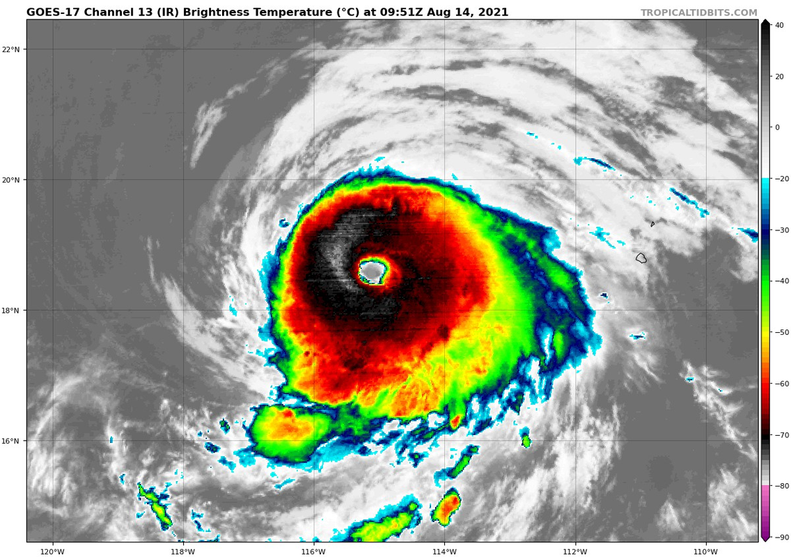
----- Current Analysis -----
Date : 14 AUG 2021 Time : 090035 UTC
Lat : 18:32:59 N Lon : 114:54:36 W


CI# /Pressure/ Vmax
5.8 / 952.5mb/109.8kt


Final T# Adj T# Raw T#
5.8 6.4 6.5

Estimated radius of max. wind based on IR : 20 km

Center Temp : +13.5C Cloud Region Temp : -69.3C

Scene Type : EYE
0 likes   

User avatar
Yellow Evan
Professional-Met
Professional-Met
Posts: 16143
Age: 27
Joined: Fri Jul 15, 2011 12:48 pm
Location: Henderson, Nevada/Honolulu, HI
Contact:

Re: EPAC: LINDA - Hurricane

#230 Postby Yellow Evan » Sat Aug 14, 2021 5:02 am

Image

Needs to shore up it's E side now. Also seems to have looked like it quietly completed an ERC on IR but there's no evidence of such otherwise.
0 likes   

User avatar
Yellow Evan
Professional-Met
Professional-Met
Posts: 16143
Age: 27
Joined: Fri Jul 15, 2011 12:48 pm
Location: Henderson, Nevada/Honolulu, HI
Contact:

Re: EPAC: LINDA - Hurricane

#231 Postby Yellow Evan » Sat Aug 14, 2021 5:04 am

AAAA-MM-DD-HH:MM Dirs Mgts Dirmx Mgtmx Temp Hr Slp Pcp
(Grados) (Nudos) (Grados) (Nudos) (Celsius) (%) (hPa) (Milimetros)
2021-08-14-09:45 226 65.12 224 75.43 25.2 40 989.1 4.06
2021-08-14-09:30 227 66.90 225 81.05 25.3 40 985.6 9.15
2021-08-14-09:15 228 75.76 224 89.42 25.3 40 980.3 18.54
2021-08-14-09:00 230 76.51 233 86.72 25.4 40 975.1 15.49
2021-08-14-08:45 236 70.19 240 85.75 25.7 40 970.1 10.67
2021-08-14-08:30 234 44.49 230 63.17 26.5 40 968.0 0.26
2021-08-14-08:15 222 25.76 234 36.93 26.3 40 966.8 0.00
2021-08-14-08:00 179 13.12 179 15.93 26.3 40 967.2 0.00
2021-08-14-07:45 142 11.88 141 15.33 26.2 40 967.6 0.00
2021-08-14-07:30 81 22.30 88 36.93 26.0 40 968.5 0.50
2021-08-14-07:15 84 50.54 87 80.67 25.2 40 969.5 5.08
2021-08-14-07:00 90 61.56 91 86.29 24.6 40 975.5 3.05
2021-08-14-06:45 74 43.74 44 91.95 24.3 40 981.2 0.00
2021-08-14-06:30 60 45.19 45 77.00 24.5 40 985.9 0.26


75 knots with 90 knot peak gusts on SE side.
0 likes   

User avatar
Yellow Evan
Professional-Met
Professional-Met
Posts: 16143
Age: 27
Joined: Fri Jul 15, 2011 12:48 pm
Location: Henderson, Nevada/Honolulu, HI
Contact:

Re: EPAC: LINDA - Hurricane

#232 Postby Yellow Evan » Sat Aug 14, 2021 5:07 am

Yellow Evan wrote:
Kingarabian wrote:
Yellow Evan wrote:
Per Scholemer and CKZ equation, would support 965-960 mbars and 95-100 knots.

Storms moving WNW typically have 10kts lower wind speeds in the western and southern quadrants compared to the N/NE. So the 110kt estimate from the NHC might not be too bad.


Yes but the winds on Clarion (idk enough about it's location - elevation? is it exposed? how much of a factor would land friction play?) were not impressive either and I derived the above estimates from the eye pressure.


Image


3m in elevation so wind obs might be a little low but pretty exposed.
3 likes   

User avatar
Kingarabian
S2K Supporter
S2K Supporter
Posts: 15980
Joined: Sat Aug 08, 2009 3:06 am
Location: Honolulu, Hawaii

Re: EPAC: LINDA - Hurricane

#233 Postby Kingarabian » Sat Aug 14, 2021 5:10 am

Yellow Evan wrote:
AAAA-MM-DD-HH:MM Dirs Mgts Dirmx Mgtmx Temp Hr Slp Pcp
(Grados) (Nudos) (Grados) (Nudos) (Celsius) (%) (hPa) (Milimetros)
2021-08-14-09:45 226 65.12 224 75.43 25.2 40 989.1 4.06
2021-08-14-09:30 227 66.90 225 81.05 25.3 40 985.6 9.15
2021-08-14-09:15 228 75.76 224 89.42 25.3 40 980.3 18.54
2021-08-14-09:00 230 76.51 233 86.72 25.4 40 975.1 15.49
2021-08-14-08:45 236 70.19 240 85.75 25.7 40 970.1 10.67
2021-08-14-08:30 234 44.49 230 63.17 26.5 40 968.0 0.26
2021-08-14-08:15 222 25.76 234 36.93 26.3 40 966.8 0.00
2021-08-14-08:00 179 13.12 179 15.93 26.3 40 967.2 0.00
2021-08-14-07:45 142 11.88 141 15.33 26.2 40 967.6 0.00
2021-08-14-07:30 81 22.30 88 36.93 26.0 40 968.5 0.50
2021-08-14-07:15 84 50.54 87 80.67 25.2 40 969.5 5.08
2021-08-14-07:00 90 61.56 91 86.29 24.6 40 975.5 3.05
2021-08-14-06:45 74 43.74 44 91.95 24.3 40 981.2 0.00
2021-08-14-06:30 60 45.19 45 77.00 24.5 40 985.9 0.26


75 knots with 90 knot peak gusts on SE side.

Yeah I think there's something up with this station. There's simply no way this tire truck of a hurricane isn't recording MH wind speeds.
Image
0 likes   
RIP Kobe Bryant

User avatar
Kingarabian
S2K Supporter
S2K Supporter
Posts: 15980
Joined: Sat Aug 08, 2009 3:06 am
Location: Honolulu, Hawaii

Re: EPAC: LINDA - Hurricane

#234 Postby Kingarabian » Sat Aug 14, 2021 5:25 am

Current Intensity Analysis


UW - CIMSS
ADVANCED DVORAK TECHNIQUE
ADT-Version 9.0
Tropical Cyclone Intensity Algorithm

----- Current Analysis -----
Date : 14 AUG 2021 Time : 094536 UTC
Lat : 18:35:24 N Lon : 115:04:11 W


CI# /Pressure/ Vmax
6.1 / 946.1mb/117.4kt


Final T# Adj T# Raw T#
6.1 6.4 6.6

Estimated radius of max. wind based on IR : 22 km

Center Temp : +15.4C Cloud Region Temp : -69.8C

Scene Type : EYE

Subtropical Adjustment : OFF

Extratropical Adjustment : OFF

Positioning Method : ARCHER POSITIONING

Ocean Basin : EAST PACIFIC
Dvorak CI > MSLP Conversion Used : CKZ Method

Tno/CI Rules : Constraint Limits : 1.3T/6hr
Weakening Flag : OFF
Rapid Dissipation Flag : OFF

C/K/Z MSLP Estimate Inputs :
- Average 34 knot radii : 92nmi
- Environmental MSLP : 1011mb

Satellite Name : GOES17
Satellite Viewing Angle : 33.3 degrees


Even the times when recon found EPAC systems weaker than Dvorak estimated, Dvorak would only be off by 10-15mph. So If this is not 125-130kts, then it's at least the NHC estimate.
0 likes   
RIP Kobe Bryant

User avatar
Yellow Evan
Professional-Met
Professional-Met
Posts: 16143
Age: 27
Joined: Fri Jul 15, 2011 12:48 pm
Location: Henderson, Nevada/Honolulu, HI
Contact:

Re: EPAC: LINDA - Hurricane

#235 Postby Yellow Evan » Sat Aug 14, 2021 5:37 am

Kingarabian wrote:
Current Intensity Analysis


UW - CIMSS
ADVANCED DVORAK TECHNIQUE
ADT-Version 9.0
Tropical Cyclone Intensity Algorithm

----- Current Analysis -----
Date : 14 AUG 2021 Time : 094536 UTC
Lat : 18:35:24 N Lon : 115:04:11 W


CI# /Pressure/ Vmax
6.1 / 946.1mb/117.4kt


Final T# Adj T# Raw T#
6.1 6.4 6.6

Estimated radius of max. wind based on IR : 22 km

Center Temp : +15.4C Cloud Region Temp : -69.8C

Scene Type : EYE

Subtropical Adjustment : OFF

Extratropical Adjustment : OFF

Positioning Method : ARCHER POSITIONING

Ocean Basin : EAST PACIFIC
Dvorak CI > MSLP Conversion Used : CKZ Method

Tno/CI Rules : Constraint Limits : 1.3T/6hr
Weakening Flag : OFF
Rapid Dissipation Flag : OFF

C/K/Z MSLP Estimate Inputs :
- Average 34 knot radii : 92nmi
- Environmental MSLP : 1011mb

Satellite Name : GOES17
Satellite Viewing Angle : 33.3 degrees


Even the times when recon found EPAC systems weaker than Dvorak estimated, Dvorak would only be off by 10-15mph. So If this is not 125-130kts, then it's at least the NHC estimate.


ADT at the time this was passing the island was 5.5 and was 5.2 at 630z. Surface obs both pressure and wind support 95. SAB was literally T4.5 FT with a CI of T5.5 at 6z.
1 likes   

User avatar
Yellow Evan
Professional-Met
Professional-Met
Posts: 16143
Age: 27
Joined: Fri Jul 15, 2011 12:48 pm
Location: Henderson, Nevada/Honolulu, HI
Contact:

Re: EPAC: LINDA - Hurricane

#236 Postby Yellow Evan » Sat Aug 14, 2021 5:45 am

Regarding Clarion Island’s observation reliability:

“ A Mexican Navy automated weather station on Clarion Island reported a peak sustained wind of 86 kt and a gust to 113 kt at 1045 UTC 3 September. The station also reported a minimum pressure of 958.1 mb at 1230 UTC, but it should be noted that the pressure observations at this station appear to run about 4 to 5 mb too low.”

From Juliette 19: https://www.nhc.noaa.gov/data/tcr/EP112019_Juliette.pdf
2 likes   

User avatar
Yellow Evan
Professional-Met
Professional-Met
Posts: 16143
Age: 27
Joined: Fri Jul 15, 2011 12:48 pm
Location: Henderson, Nevada/Honolulu, HI
Contact:

Re: EPAC: LINDA - Hurricane

#237 Postby Yellow Evan » Sat Aug 14, 2021 5:50 am

Image

B seems thick but W looks shallower and W ring remains incomplete. We are rapidly approaching fix time (only ~70 mins away).
0 likes   

User avatar
Yellow Evan
Professional-Met
Professional-Met
Posts: 16143
Age: 27
Joined: Fri Jul 15, 2011 12:48 pm
Location: Henderson, Nevada/Honolulu, HI
Contact:

Re: EPAC: LINDA - Hurricane

#238 Postby Yellow Evan » Sat Aug 14, 2021 6:28 am

Image

T6.0. B thickness lacking.
0 likes   

User avatar
Yellow Evan
Professional-Met
Professional-Met
Posts: 16143
Age: 27
Joined: Fri Jul 15, 2011 12:48 pm
Location: Henderson, Nevada/Honolulu, HI
Contact:

Re: EPAC: LINDA - Hurricane

#239 Postby Yellow Evan » Sat Aug 14, 2021 6:29 am

----- Current Analysis -----
Date : 14 AUG 2021 Time : 104536 UTC
Lat : 18:33:35 N Lon : 115:16:11 W


CI# /Pressure/ Vmax
6.3 / 941.9mb/122.2kt


Final T# Adj T# Raw T#
6.3 6.3 6.3

Estimated radius of max. wind based on IR : 25 km

Center Temp : +15.4C Cloud Region Temp : -67.2C

Scene Type : EYE
0 likes   

User avatar
Yellow Evan
Professional-Met
Professional-Met
Posts: 16143
Age: 27
Joined: Fri Jul 15, 2011 12:48 pm
Location: Henderson, Nevada/Honolulu, HI
Contact:

Re: EPAC: LINDA - Hurricane

#240 Postby Yellow Evan » Sat Aug 14, 2021 6:55 am

Image

Clear cut T6.0.
0 likes   


Return to “2021”

Who is online

Users browsing this forum: No registered users and 4 guests