

ATL: FRED - Post-Tropical - Discussion
Moderator: S2k Moderators
Re: ATL: FRED - Tropical Depression - Discussion
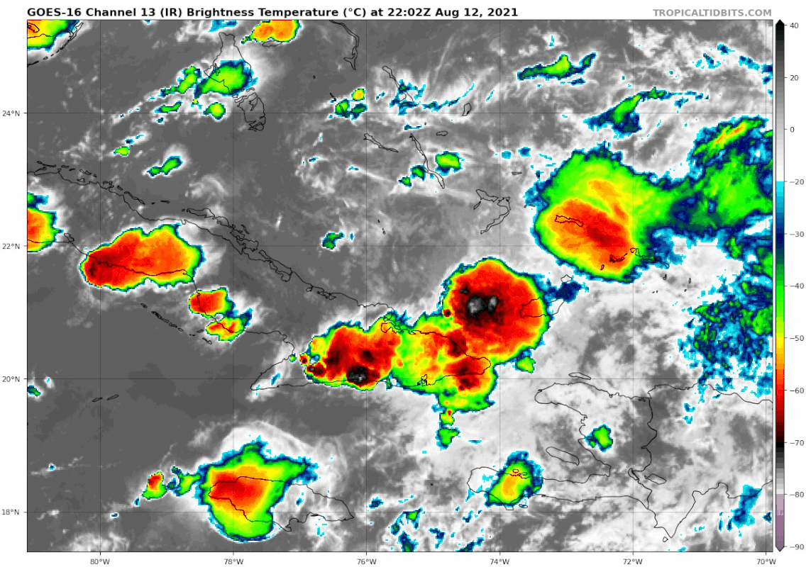
Shear near 20 knots is not keeping it from starting to reorgonize.
6 likes

Re: ATL: FRED - Tropical Depression - Discussion
NDG wrote:Shear near 20 knots is not keeping it from starting to reorgonize.
https://i.imgur.com/F2ARSWz.gif
sometimes land friction can do wonders.
0 likes
Robbielyn McCrary
I know just about enough to sound like I know what I'm talking about sometimes. But for your safety please follow the nhc for truly professional forecasting.
I know just about enough to sound like I know what I'm talking about sometimes. But for your safety please follow the nhc for truly professional forecasting.

Re: ATL: FRED - Tropical Depression - Discussion
NDG wrote:Shear near 20 knots is not keeping it from starting to reorgonize.
https://i.imgur.com/F2ARSWz.gif
Looks like Fred is no longer Yabba-Dabba-Doomed. Quite an impressive blowup of convection all of a sudden.
10 likes
Irene '11 Sandy '12 Hermine '16 5/15/2018 Derecho Fay '20 Isaias '20 Elsa '21 Henri '21 Ida '21
I am only a meteorology enthusiast who knows a decent amount about tropical cyclones. Look to the professional mets, the NHC, or your local weather office for the best information.
I am only a meteorology enthusiast who knows a decent amount about tropical cyclones. Look to the professional mets, the NHC, or your local weather office for the best information.
-
AutoPenalti
- Category 5

- Posts: 4091
- Age: 29
- Joined: Mon Aug 17, 2015 4:16 pm
- Location: Ft. Lauderdale, Florida
Re: ATL: FRED - Tropical Depression - Discussion
NDG wrote:Shear near 20 knots is not keeping it from starting to reorgonize.
https://i.imgur.com/F2ARSWz.gif
LLC is still moving though.
0 likes
The posts in this forum are NOT official forecasts and should not be used as such. They are just the opinion of the poster and may or may not be backed by sound meteorological data. They are NOT endorsed by any professional institution or STORM2K. For official information, please refer to products from the NHC and NWS.
Model Runs Cheat Sheet:
GFS (5:30 AM/PM, 11:30 AM/PM)
HWRF, GFDL, UKMET, NAVGEM (6:30-8:00 AM/PM, 12:30-2:00 AM/PM)
ECMWF (1:45 AM/PM)
TCVN is a weighted averaged
-
ScottNAtlanta

- Category 5
- Posts: 2535
- Joined: Sat May 25, 2013 3:11 pm
- Location: Atlanta, GA
Re: ATL: FRED - Tropical Depression - Discussion
robbielyn wrote:NDG wrote:Shear near 20 knots is not keeping it from starting to reorgonize.
https://i.imgur.com/F2ARSWz.gif
sometimes land friction can do wonders.
Actually...the land is holding it back for a short while. If you look over the Cuban land mass, all those thunderstorms are starving the center of convergence. Once we get into tonight, it will reverse.
That convection might be strong enough to pull the center underneath the covection
1 likes
The posts in this forum are NOT official forecast and should not be used as such. They are just the opinion of the poster and may or may not be backed by sound meteorological data. They are NOT endorsed by any professional institution or storm2k.org. For official information, please refer to the NHC and NWS products.
-
tolakram
- Admin

- Posts: 20186
- Age: 62
- Joined: Sun Aug 27, 2006 8:23 pm
- Location: Florence, KY (name is Mark)
Re: ATL: FRED - Tropical Depression - Discussion
Last light.

2 likes
M a r k
- - - - -
Join us in chat: Storm2K Chatroom Invite. Android and IOS apps also available.
The posts in this forum are NOT official forecasts and should not be used as such. Posts are NOT endorsed by any professional institution or STORM2K.org. For official information and forecasts, please refer to NHC and NWS products.
Re: ATL: FRED - Tropical Depression - Discussion
Considering we have a decent blowup at dmin and Fred remains within the disruptive downslope zone off of eastern Cuba, its chances should improve markedly with dmax and sufficient longitude as it pulls away from those high mountains in eastern Cuba. As we ramp up toward peak season, it only takes a spin to win. The possibility this gets bit stronger than expected certainly deserves a spot in everyone's thought process..especially folks in the keys. Things could get a good bit more interesting in the next 12-24 hours if Fred can gain and maintain some solid convection.
4 likes

-
tolakram
- Admin
- Posts: 20186
- Age: 62
- Joined: Sun Aug 27, 2006 8:23 pm
- Location: Florence, KY (name is Mark)
Re: ATL: FRED - Tropical Depression - Discussion
Bastardi has a writeup on Weatherbell premium today, these are nice because it stays on topic.  Still drumming about how the models always miss the MJO phase change and that phase II usually means in close development. He sees a strengthening hurricane into the panhandle or even west of that. Ignoring his strength predictions, if we end up with a stronger Fred than the models are currently showing then once again the MJO phase change idea has merit.
5 likes
M a r k
- - - - -
Join us in chat: Storm2K Chatroom Invite. Android and IOS apps also available.
The posts in this forum are NOT official forecasts and should not be used as such. Posts are NOT endorsed by any professional institution or STORM2K.org. For official information and forecasts, please refer to NHC and NWS products.
- - - - -
Join us in chat: Storm2K Chatroom Invite. Android and IOS apps also available.
The posts in this forum are NOT official forecasts and should not be used as such. Posts are NOT endorsed by any professional institution or STORM2K.org. For official information and forecasts, please refer to NHC and NWS products.

Re: ATL: FRED - Tropical Depression - Discussion
NDG wrote:Shear near 20 knots is not keeping it from starting to reorgonize.
https://i.imgur.com/F2ARSWz.gif
Boy, ain't that a fact?!! There's no way I would have expected this solid of a convective blow-up over center until m-a-y-b-e mid-day tomorrow? Pretty impressive actually. Let's see how long it can be sustained tonight given the shear. One interesting note however..... Fred's slower motion in combination with UL shear becoming southerly (rather then WSW), should induce a better upper air environment by sometime early Saturday I think.
0 likes
Andy D
(For official information, please refer to the NHC and NWS products.)
(For official information, please refer to the NHC and NWS products.)
-
wxman57

- Moderator-Pro Met

- Posts: 23175
- Age: 68
- Joined: Sat Jun 21, 2003 8:06 pm
- Location: Houston, TX (southwest)
Re: ATL: FRED - Tropical Depression - Discussion
The surface center appears to be west of the convection. Recon is finding a center aloft to the east. Still a good bit of shear. That 170 kt SFMR might be questionable.
3 likes
-
johngaltfla

- Category 5
- Posts: 2073
- Joined: Sun Jul 10, 2005 9:17 pm
- Location: Sarasota County, FL
- Contact:
Re: ATL: FRED - Tropical Depression - Discussion
tolakram wrote:Bastardi has a writeup on Weatherbell premium today, these are nice because it stays on topic.
IF this change idea occurs, it will be fascinating to watch if there is a future impact on forecasting across the board.
1 likes
Re: ATL: FRED - Tropical Depression - Discussion
BTW, both recons are finding the LLC a little further SE than what it was estimated at 5 PM.
3 likes
-
tolakram
- Admin
- Posts: 20186
- Age: 62
- Joined: Sun Aug 27, 2006 8:23 pm
- Location: Florence, KY (name is Mark)
Re: ATL: FRED - Tropical Depression - Discussion
COD shortwave
https://weather.cod.edu/satrad/?parms=subregional-Cuba-07-48-1-100-1&checked=map&colorbar=undefined
https://weather.cod.edu/satrad/?parms=subregional-Cuba-07-48-1-100-1&checked=map&colorbar=undefined
0 likes
M a r k
- - - - -
Join us in chat: Storm2K Chatroom Invite. Android and IOS apps also available.
The posts in this forum are NOT official forecasts and should not be used as such. Posts are NOT endorsed by any professional institution or STORM2K.org. For official information and forecasts, please refer to NHC and NWS products.
- - - - -
Join us in chat: Storm2K Chatroom Invite. Android and IOS apps also available.
The posts in this forum are NOT official forecasts and should not be used as such. Posts are NOT endorsed by any professional institution or STORM2K.org. For official information and forecasts, please refer to NHC and NWS products.
-
SunnyThoughts
- Category 5
- Posts: 2263
- Joined: Wed Jul 09, 2003 12:42 pm
- Location: Pensacola, Florida
Re: ATL: FRED - Tropical Depression - Discussion
chaser1 wrote:NDG wrote:Shear near 20 knots is not keeping it from starting to reorgonize.
https://i.imgur.com/F2ARSWz.gif
Boy, ain't that a fact?!! There's no way I would have expected this solid of a convective blow-up over center until m-a-y-b-e mid-day tomorrow? Pretty impressive actually. Let's see how long it can be sustained tonight given the shear. One interesting note however..... Fred's slower motion in combination with UL shear becoming southerly (rather then WSW), should induce a better upper air environment by sometime early Saturday I think.
Did any of the model predict this happening this soon? Hopefully it doesn't last and stays decoupled. Panhandle has had So much rain the last 2 weeks.im afraid even a 60 mph TS would cause a lot of chaos with trees etc.
0 likes
Re: ATL: FRED - Tropical Depression - Discussion
wxman57 wrote:The surface center appears to be west of the convection. Recon is finding a center aloft to the east. Still a good bit of shear. That 170 kt SFMR might be questionable.
“Might be”?
What could even cause an erronous SFMR reading that high?
0 likes
Irene '11 Sandy '12 Hermine '16 5/15/2018 Derecho Fay '20 Isaias '20 Elsa '21 Henri '21 Ida '21
I am only a meteorology enthusiast who knows a decent amount about tropical cyclones. Look to the professional mets, the NHC, or your local weather office for the best information.
I am only a meteorology enthusiast who knows a decent amount about tropical cyclones. Look to the professional mets, the NHC, or your local weather office for the best information.
-
NXStumpy_Robothing
- Category 1

- Posts: 335
- Age: 25
- Joined: Fri Jun 05, 2020 11:50 pm
- Location: North Georgia
Re: ATL: FRED - Tropical Depression - Discussion
aspen wrote:wxman57 wrote:The surface center appears to be west of the convection. Recon is finding a center aloft to the east. Still a good bit of shear. That 170 kt SFMR might be questionable.
“Might be”?
What could even cause an erronous SFMR reading that high?
Well, I'm pretty sure it was passing over part of a hill or mountain on an island when that SFMR reading popped up. FL winds were around 30-35kt at that time fwiw.
0 likes
Undergraduate Meteorology Student, Georgia Institute of Technology
Re: ATL: FRED - Tropical Depression - Discussion
NDG wrote:Shear near 20 knots is not keeping it from starting to reorgonize.
https://i.imgur.com/F2ARSWz.gif
Florida Straits is a furnace, if Fred slows a bit and the low dies out SFl could see more impacts.
4 likes
-
AtlanticWind

- S2K Supporter

- Posts: 1898
- Age: 67
- Joined: Sun Aug 08, 2004 9:57 pm
- Location: Plantation,Fla
-
AtlanticWind
- S2K Supporter
- Posts: 1898
- Age: 67
- Joined: Sun Aug 08, 2004 9:57 pm
- Location: Plantation,Fla
Re: ATL: FRED - Tropical Depression - Discussion
Center under convection , still disorganized but trying for comeback.
Slower movement interesting
Slower movement interesting
0 likes
Who is online
Users browsing this forum: No registered users and 52 guests