ATL: FRED - Models
Moderator: S2k Moderators
-
Miami Storm Tracker

- Category 4

- Posts: 916
- Age: 68
- Joined: Sun Jun 13, 2010 10:12 pm
- Location: Key Largo, Fla.
- Contact:
Re: ATL: SIX - Models
Not liking the turn into Key Largo at all no matter how small it may look.
0 likes
Re: ATL: FRED - Models
0z Icon stays weak into the Keys (shift left from earlier runs), this one goes over most of Hispaniola, though, then rides ... well crawls slowly... up just offshore the west coast of Florida.
I think the biggest takeaway here is how much it slows down in the Gulf.

I think the biggest takeaway here is how much it slows down in the Gulf.
1 likes
-
StPeteMike

- Category 2

- Posts: 656
- Joined: Thu Jun 07, 2018 11:26 pm
Re: ATL: FRED - Models
Wondering why the lack of attention to this thread until I saw the 0z GFS pretty much keeps this a sloppy Fred his whole lifespan haha
0 likes
The above post is not official and should not be used as such. It is the opinion of the poster and may or may not be backed by sound meteorological data. It is not endorsed by any professional institution or storm2k.org. For official information, please refer to the NHC and NWS products.
-
SouthFLTropics

- Category 5

- Posts: 4258
- Age: 50
- Joined: Thu Aug 14, 2003 8:04 am
- Location: Port St. Lucie, Florida
Re: ATL: FRED - Models
Are my eyes playing tricks on me or has the HWRF gone bonkers at 00z. Looks like it initialized Fred near the PR coast and then moves it SW for the next 6 hours.
0 likes
Fourth Generation Florida Native
Personal Storm History: David 79, Andrew 92, Erin 95, Floyd 99, Irene 99, Frances 04, Jeanne 04, Wilma 05, Matthew 16, Irma 17, Ian 22, Nicole 22, Milton 24
Personal Storm History: David 79, Andrew 92, Erin 95, Floyd 99, Irene 99, Frances 04, Jeanne 04, Wilma 05, Matthew 16, Irma 17, Ian 22, Nicole 22, Milton 24

Re: ATL: FRED - Models
I noticed that too, the structure it shows also looks nothing like what actual radar shows.SouthFLTropics wrote:Are my eyes playing tricks on me or has the HWRF gone bonkers at 00z. Looks like it initialized Fred near the PR coast and then moves it SW for the next 6 hours.
0 likes
-
ElectricStorm

- Category 5
- Posts: 5148
- Age: 25
- Joined: Tue Aug 13, 2019 11:23 pm
- Location: Norman, OK
Re: ATL: FRED - Models
HWRF has it going right for the tall mountains so this will be interesting to see how it plays out.
0 likes
B.S Meteorology, University of Oklahoma '25
Please refer to the NHC, NWS, or SPC for official information.
Please refer to the NHC, NWS, or SPC for official information.
Re: ATL: FRED - Models
It looks like it decides that a vortex to the SW takes over and runs it from there. Very unlikely and a junk model run already IMO.Woofde wrote:I noticed that too, the structure it shows also looks nothing like what actual radar shows.SouthFLTropics wrote:Are my eyes playing tricks on me or has the HWRF gone bonkers at 00z. Looks like it initialized Fred near the PR coast and then moves it SW for the next 6 hours.
0 likes
-
ElectricStorm
- Category 5
- Posts: 5148
- Age: 25
- Joined: Tue Aug 13, 2019 11:23 pm
- Location: Norman, OK
Re: ATL: FRED - Models
Hmm HWRF has it going SW at the start of the run but on radar that's not happening...
0 likes
B.S Meteorology, University of Oklahoma '25
Please refer to the NHC, NWS, or SPC for official information.
Please refer to the NHC, NWS, or SPC for official information.
-
AutoPenalti
- Category 5
- Posts: 4091
- Age: 29
- Joined: Mon Aug 17, 2015 4:16 pm
- Location: Ft. Lauderdale, Florida
Re: ATL: FRED - Models
what the hell HWRF lol
is this as a result of the LLC tucking in the MLC to the SW?
is this as a result of the LLC tucking in the MLC to the SW?
0 likes
The posts in this forum are NOT official forecasts and should not be used as such. They are just the opinion of the poster and may or may not be backed by sound meteorological data. They are NOT endorsed by any professional institution or STORM2K. For official information, please refer to products from the NHC and NWS.
Model Runs Cheat Sheet:
GFS (5:30 AM/PM, 11:30 AM/PM)
HWRF, GFDL, UKMET, NAVGEM (6:30-8:00 AM/PM, 12:30-2:00 AM/PM)
ECMWF (1:45 AM/PM)
TCVN is a weighted averaged
-
Shell Mound
- Category 5
- Posts: 2432
- Age: 33
- Joined: Thu Sep 07, 2017 3:39 pm
- Location: St. Petersburg, FL → Scandinavia
Re: ATL: SIX - Models
AutoPenalti wrote:tolakram wrote:toad strangler wrote:18z GFS doing it's best to poof PTC6 over Cuba
Toss this run, init was hundreds of miles too far south if that radar MLC is the real deal.
Yeah but now all of the sudden unfavorable conditions return. Look how the ULL suddenly strengthens
Actually, the latest GFS shows more UL divergence and hence anticyclonic flow north of Cuba and over the Bahamas by 66h (18Z 13 Aug) vs. previous runs.
0 likes
CVW / MiamiensisWx / Shell Mound
The posts in this forum are NOT official forecasts and should not be used as such. They are just the opinion of the poster and may or may not be backed by sound meteorological data. They are NOT endorsed by any professional institution or STORM2K. For official information, please refer to products from the NHC and NWS.
-
ElectricStorm
- Category 5
- Posts: 5148
- Age: 25
- Joined: Tue Aug 13, 2019 11:23 pm
- Location: Norman, OK
Re: ATL: FRED - Models
HWRF dives it SW into Cuba after it clears Hispaniola. Until I see actual evidence this might happen I'm throwing this run out
1 likes
B.S Meteorology, University of Oklahoma '25
Please refer to the NHC, NWS, or SPC for official information.
Please refer to the NHC, NWS, or SPC for official information.

Re: ATL: FRED - Models
6z GFS looking much more robust with Fred

Sent from my iPhone using Tapatalk
Sent from my iPhone using Tapatalk
0 likes

Re: ATL: FRED - Models
Expecting another shift north with the cone. 00z euro and 06z GFS bring this Thru the southern peninsula before moving Into the gulf.
Sent from my iPhone using Tapatalk[/quote]
Sent from my iPhone using Tapatalk[/quote]
0 likes

Re: ATL: FRED - Models
N2FSU wrote:6z GFS looking much more robust with Fred
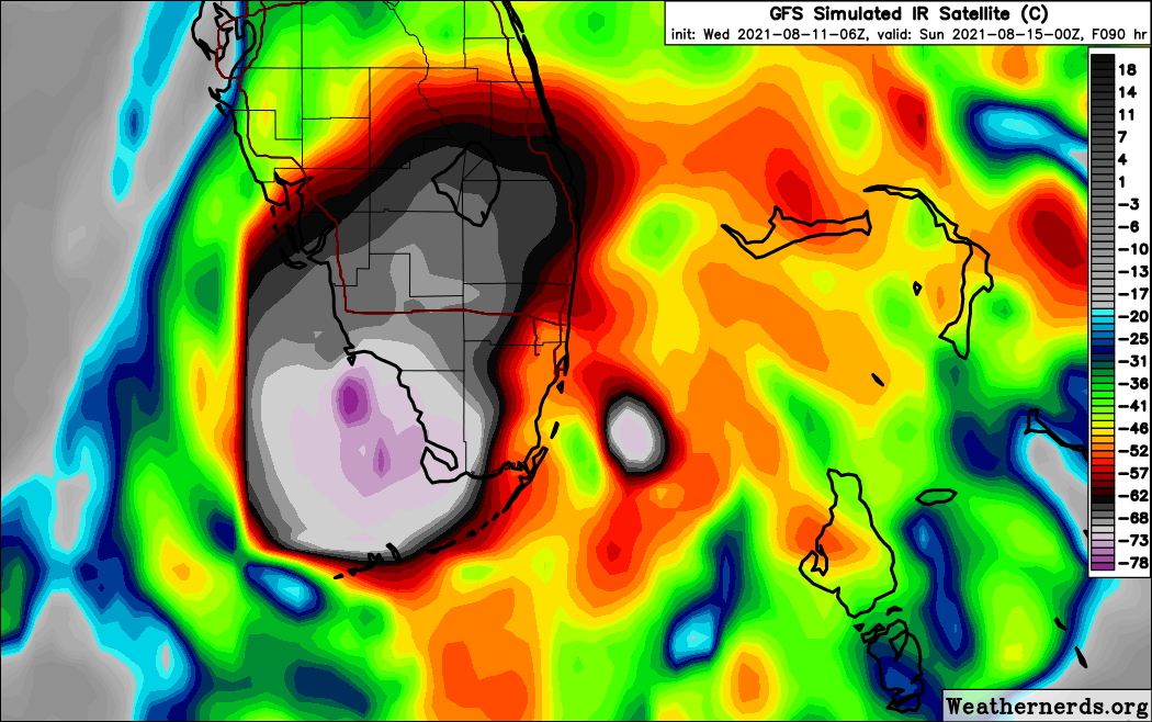
https://uploads.tapatalk-cdn.com/20210811/6530c3f357694badf09012fed7a54232.jpg
Also landfalls southern tip of fl rides up west coast of fl exits into the big bend.
Sent from my iPhone using Tapatalk
0 likes
Robbielyn McCrary
I know just about enough to sound like I know what I'm talking about sometimes. But for your safety please follow the nhc for truly professional forecasting.
I know just about enough to sound like I know what I'm talking about sometimes. But for your safety please follow the nhc for truly professional forecasting.
-
SFLcane

- S2K Supporter

- Posts: 10281
- Age: 48
- Joined: Sat Jun 05, 2010 1:44 pm
- Location: Lake Worth Florida
Re: ATL: FRED - Models
Gfs stronger and east.
Last edited by SFLcane on Wed Aug 11, 2021 5:46 am, edited 1 time in total.
1 likes

Re: ATL: FRED - Models
o6z GFS and 0z Euro are fairly similar in the track, the Euro remaining more to the right.
I guess it all depends exactly where it trackds near the eastern GOM, offshore the whole time will mean a stronger system vs near the coast or just inland.


I guess it all depends exactly where it trackds near the eastern GOM, offshore the whole time will mean a stronger system vs near the coast or just inland.
1 likes
Re: ATL: FRED - Models
What a joke the HWRF has become, it has gone from a Cat 1/Cat 2 hurricane for SE FL to barely a TD approaching SE FL in less than 3 runs.
3 likes
-
jlauderdal
- S2K Supporter
- Posts: 7240
- Joined: Wed May 19, 2004 5:46 am
- Location: NE Fort Lauderdale
- Contact:
Re: RE: Re: ATL: FRED - Models
Become or was a joke, i hoisted a warning about it during elsa and pre-fred...it creates tons of excotement but rarely deliversNDG wrote:What a joke the HWRF has become, it has gone from a Cat 1/Cat 2 hurricane for SE FL to barely a TD approaching SE FL in less than 3 runs.
1 likes
-
toad strangler

- S2K Supporter
- Posts: 4546
- Joined: Sun Jul 28, 2013 3:09 pm
- Location: Earth
- Contact:
Re: ATL: FRED - Models
Intensity is still the great untamed frontier in modeling. We all know that. ESPECIALLY with a system that gets entangled by a GA island.
4 likes
My Weather Station
https://www.wunderground.com/dashboard/pws/KFLPORTS603
https://www.wunderground.com/dashboard/pws/KFLPORTS603
Re: RE: Re: ATL: FRED - Models
jlauderdal wrote:Become or was a joke, i hoisted a warning about it during elsa and pre-fred...it creates tons of excotement but rarely deliversNDG wrote:What a joke the HWRF has become, it has gone from a Cat 1/Cat 2 hurricane for SE FL to barely a TD approaching SE FL in less than 3 runs.
That it has become this year is what I am saying.
1 likes
Who is online
Users browsing this forum: No registered users and 22 guests