2021 EPAC Season

This is the general tropical discussion area. Anyone can take their shot at predicting a storms path.

Moderator: S2k Moderators

Forum rules

The posts in this forum are NOT official forecasts and should not be used as such. They are just the opinion of the poster and may or may not be backed by sound meteorological data. They are NOT endorsed by any professional institution or STORM2K. For official information, please refer to products from the National Hurricane Center and National Weather Service.

Help Support Storm2K
Message
Author
User avatar
aspen
Category 5
Category 5
Posts: 8818
Joined: Sat Oct 12, 2019 7:10 pm
Location: Connecticut, USA

Re: 2021 EPAC Season

#781 Postby aspen » Thu Aug 05, 2021 2:46 pm


I don’t see how the EPac could be this favored in a -ENSO year, and how the MJO could remain stuck over the EPac with continued sinking motion over the Atlantic.
0 likes   
Irene '11 Sandy '12 Hermine '16 5/15/2018 Derecho Fay '20 Isaias '20 Elsa '21 Henri '21 Ida '21

I am only a meteorology enthusiast who knows a decent amount about tropical cyclones. Look to the professional mets, the NHC, or your local weather office for the best information.

User avatar
Yellow Evan
Professional-Met
Professional-Met
Posts: 16143
Age: 27
Joined: Fri Jul 15, 2011 12:48 pm
Location: Henderson, Nevada/Honolulu, HI
Contact:

Re: 2021 EPAC Season

#782 Postby Yellow Evan » Thu Aug 05, 2021 2:51 pm

Image

12z ECMWF day 10 ends like this.
0 likes   

User avatar
captainbarbossa19
Professional-Met
Professional-Met
Posts: 1092
Age: 27
Joined: Wed Aug 21, 2019 11:09 pm
Location: Beaumont, TX

Re: 2021 EPAC Season

#783 Postby captainbarbossa19 » Thu Aug 05, 2021 2:55 pm

aspen wrote:

I don’t see how the EPac could be this favored in a -ENSO year, and how the MJO could remain stuck over the EPac with continued sinking motion over the Atlantic.


Even if the models are right about continued activity, the EPAC is going to eventually run out of juice for storms. This is going to give the Atlantic a strong edge near peak-season.
0 likes   

User avatar
Category5Kaiju
Category 5
Category 5
Posts: 4097
Joined: Thu Dec 24, 2020 12:45 pm
Location: Seattle

Re: 2021 EPAC Season

#784 Postby Category5Kaiju » Thu Aug 05, 2021 3:00 pm

Either the models are very biased toward an El Niño or positive PDO like state, or we’re entering some weird La Niña that also happens to favor activity in the EPAC for mysterious reasons. I think the former is more believable imho
0 likes   
Unless explicitly stated, all info in my posts is based on my own opinions and observations. Tropical storms and hurricanes can be extremely dangerous. Do not think you can beat Mother Nature. Refer to an accredited weather research agency or meteorologist if you need to make serious decisions regarding an approaching storm.

User avatar
Kingarabian
S2K Supporter
S2K Supporter
Posts: 15980
Joined: Sat Aug 08, 2009 3:06 am
Location: Honolulu, Hawaii

Re: 2021 EPAC Season

#785 Postby Kingarabian » Thu Aug 05, 2021 3:21 pm

The reasoning behind the models for continued EPAC activity is becoming clear with the time frame coming in. Seems that they're installing a temporarily American standing wave. Despite the hostile indicators in place such as a -ENSO/-PM/-PDO, this standing wave can allow extended EPAC activity. Something sorta similar happened in 2016 and 2017. I'll believe it if we do get four named systems over the next 2 weeks.
2 likes   
RIP Kobe Bryant

User avatar
Yellow Evan
Professional-Met
Professional-Met
Posts: 16143
Age: 27
Joined: Fri Jul 15, 2011 12:48 pm
Location: Henderson, Nevada/Honolulu, HI
Contact:

Re: 2021 EPAC Season

#786 Postby Yellow Evan » Thu Aug 05, 2021 4:01 pm

aspen wrote:

I don’t see how the EPac could be this favored in a -ENSO year, and how the MJO could remain stuck over the EPac with continued sinking motion over the Atlantic.


Image

Not even an MJO issue really. GFS is just showing an American Standing Wave lol.
0 likes   

User avatar
Category5Kaiju
Category 5
Category 5
Posts: 4097
Joined: Thu Dec 24, 2020 12:45 pm
Location: Seattle

Re: 2021 EPAC Season

#787 Postby Category5Kaiju » Thu Aug 05, 2021 4:07 pm

Yellow Evan wrote:
aspen wrote:

I don’t see how the EPac could be this favored in a -ENSO year, and how the MJO could remain stuck over the EPac with continued sinking motion over the Atlantic.


https://cdn.discordapp.com/attachments/733552978572869632/872895631524499466/image0.jpg

Not even an MJO issue really. GFS is just showing an American Standing Wave lol.


It sure loves the 80s :D
0 likes   
Unless explicitly stated, all info in my posts is based on my own opinions and observations. Tropical storms and hurricanes can be extremely dangerous. Do not think you can beat Mother Nature. Refer to an accredited weather research agency or meteorologist if you need to make serious decisions regarding an approaching storm.

User avatar
Yellow Evan
Professional-Met
Professional-Met
Posts: 16143
Age: 27
Joined: Fri Jul 15, 2011 12:48 pm
Location: Henderson, Nevada/Honolulu, HI
Contact:

Re: 2021 EPAC Season

#788 Postby Yellow Evan » Thu Aug 05, 2021 5:02 pm

Kingarabian wrote:The reasoning behind the models for continued EPAC activity is becoming clear with the time frame coming in. Seems that they're installing a temporarily American standing wave. Despite the hostile indicators in place such as a -ENSO/-PM/-PDO, this standing wave can allow extended EPAC activity. Something sorta similar happened in 2016 and 2017. I'll believe it if we do get four named systems over the next 2 weeks.


Okay let's back up here because 1) I've implied otherwise earlier in the thread and 2) I've wanted to explain my current point for a few weeks.

Image

This is the 30 day anomaly map. Notice a -VP anomaly from 120-150W, which is probably too far west to have a huge impact at least in a positive light, as well as a +VP anomaly near Central American meaning a weaker monsoon.

Image

1977 (and some other 70s seasons) had a somewhat similar -VP setup in the Pacific to the last 30 days and a +VP setup near Central America.

Image

1982-1994 (excluding 1988-89) all to varying strengths had a -VP near the Americas that enhanced the monsoon. This is what I'm referring to when I mean the American standing wave. Also of note is how dry Africa is.

Image

After 1995-1997, the ASW seemed to retreat as conditions moved towards the Atlantic. A rising cell has been present for most of the years since then over the EPAC but with little activity to show for it, I'm not sure what good it did. This is also not an American standing wave and I'm not really convinced it's helped the basin at all. Maybe it has displaced genesis to the north or northwest, which has limited the potential of long tracked storms at least without a +PMM.

Image

Now here is 2016/17. Similar setup. Perhaps the +PMM allowed the EPAC rising cell to be taking advantage of.
5 likes   

User avatar
Kingarabian
S2K Supporter
S2K Supporter
Posts: 15980
Joined: Sat Aug 08, 2009 3:06 am
Location: Honolulu, Hawaii

Re: 2021 EPAC Season

#789 Postby Kingarabian » Thu Aug 05, 2021 6:12 pm

Yellow Evan wrote:
Kingarabian wrote:The reasoning behind the models for continued EPAC activity is becoming clear with the time frame coming in. Seems that they're installing a temporarily American standing wave. Despite the hostile indicators in place such as a -ENSO/-PM/-PDO, this standing wave can allow extended EPAC activity. Something sorta similar happened in 2016 and 2017. I'll believe it if we do get four named systems over the next 2 weeks.


Okay let's back up here because 1) I've implied otherwise earlier in the thread and 2) I've wanted to explain my current point for a few weeks.

[url]https://i.imgur.com/swWx0jn.png[url]

This is the 30 day anomaly map. Notice a -VP anomaly from 120-150W, which is probably too far west to have a huge impact at least in a positive light, as well as a +VP anomaly near Central American meaning a weaker monsoon.

[url]https://i.imgur.com/eKXGgMa.png[/rl]

1977 (and some other 70s seasons) had a somewhat similar -VP setup in the Pacific to the last 30 days and a +VP setup near Central America.

[url]https://i.imgur.com/6ld7CHJ.png[/rl]

1982-1994 (excluding 1988-89) all to varying strengths had a -VP near the Americas that enhanced the monsoon. This is what I'm referring to when I mean the American standing wave. Also of note is how dry Africa is.

[url]https://i.imgur.com/WrfXltd.png[url]

After 1995-1997, the ASW seemed to retreat as conditions moved towards the Atlantic. A rising cell has been present for most of the years since then over the EPAC but with little activity to show for it, I'm not sure what good it did. This is also not an American standing wave and I'm not really convinced it's helped the basin at all. Maybe it has displaced genesis to the north or northwest, which has limited the potential of long tracked storms at least without a +PMM.

[url]https://i.imgur.com/gDakunQ.png[url]

Now here is 2016/17. Similar setup. Perhaps the +PMM allowed the EPAC rising cell to be taking advantage of.


So it's not an EPAC cell nor is it an American standing wave. We'll see how the VP anomaly maps looks by September. If we do get to Nora or Olaf, then there should be a significant amount of -VP200 anomalies closer to Mexico/120W that will make it look like 2016/2017.
0 likes   
RIP Kobe Bryant

User avatar
Kingarabian
S2K Supporter
S2K Supporter
Posts: 15980
Joined: Sat Aug 08, 2009 3:06 am
Location: Honolulu, Hawaii

Re: 2021 EPAC Season

#790 Postby Kingarabian » Thu Aug 05, 2021 6:23 pm

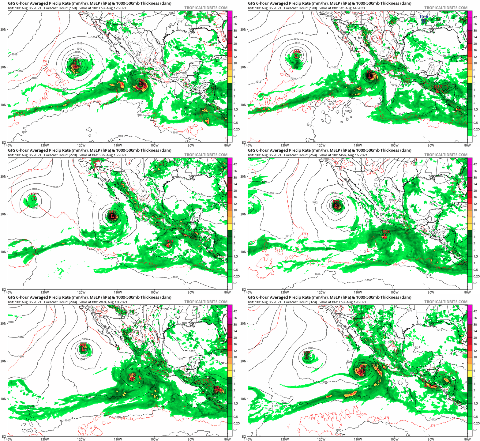
18z GFS all the way to Nora.
0 likes   
RIP Kobe Bryant

User avatar
Kingarabian
S2K Supporter
S2K Supporter
Posts: 15980
Joined: Sat Aug 08, 2009 3:06 am
Location: Honolulu, Hawaii

Re: 2021 EPAC Season

#791 Postby Kingarabian » Thu Aug 05, 2021 6:35 pm

Why is the 0/60 diturbance not 50/80? Invest should be up for it. EPS develops it in 72 hours.

12z 16day EPS only shows up to Marty.
0 likes   
RIP Kobe Bryant

User avatar
cycloneye
Admin
Admin
Posts: 145313
Age: 68
Joined: Thu Oct 10, 2002 10:54 am
Location: San Juan, Puerto Rico

Re: 2021 EPAC Season

#792 Postby cycloneye » Thu Aug 05, 2021 6:41 pm

A broad area of low pressure is expected to develop a few hundred
miles offshore of the southwestern coast of Mexico this weekend.
Environmental conditions are forecast to be conducive for gradual
development thereafter, and a tropical depression could form early
next week while the system moves west-northwestward at 10 to 15 mph,
parallel to and offshore of the coast of southwestern Mexico.
* Formation chance through 48 hours...low...near 0 percent.
* Formation chance through 5 days...medium...60 percent.
0 likes   
Visit the Caribbean-Central America Weather Thread where you can find at first post web cams,radars
and observations from Caribbean basin members Click Here

User avatar
gatorcane
S2K Supporter
S2K Supporter
Posts: 23691
Age: 47
Joined: Sun Mar 13, 2005 3:54 pm
Location: Boca Raton, FL

Re: 2021 EPAC Season

#793 Postby gatorcane » Thu Aug 05, 2021 7:44 pm

Kingarabian wrote:18z GFS all the way to Nora.


The EPAC looks to be on fire :double: :eek:

Image
0 likes   

User avatar
Yellow Evan
Professional-Met
Professional-Met
Posts: 16143
Age: 27
Joined: Fri Jul 15, 2011 12:48 pm
Location: Henderson, Nevada/Honolulu, HI
Contact:

Re: 2021 EPAC Season

#794 Postby Yellow Evan » Thu Aug 05, 2021 7:48 pm

Image

EPS control has favorable conditions for ~12 more days. Likely to get Kevin and Linda by then and maybe Marty.
0 likes   

User avatar
Kingarabian
S2K Supporter
S2K Supporter
Posts: 15980
Joined: Sat Aug 08, 2009 3:06 am
Location: Honolulu, Hawaii

Re: 2021 EPAC Season

#795 Postby Kingarabian » Fri Aug 06, 2021 2:56 am

00z GFS looked a lot more realistic. Only shows two more named system. There is vorticity signature for two more systems but they both don't develop.

00z Euro and CMC go up to Marty.

00z EPS goes up to Nora.
0 likes   
RIP Kobe Bryant

User avatar
Category5Kaiju
Category 5
Category 5
Posts: 4097
Joined: Thu Dec 24, 2020 12:45 pm
Location: Seattle

Re: 2021 EPAC Season

#796 Postby Category5Kaiju » Fri Aug 06, 2021 12:33 pm

For now the NHC still only has one AOI highlighted in the EPAC (which would likely be Kevin). Other than that (at least so far) it does not seem like the NHC is interested in highlighting any additional AOIs that would have been easily highlighted by now should the runs showing continous, copious EPAC activity be believed.
0 likes   
Unless explicitly stated, all info in my posts is based on my own opinions and observations. Tropical storms and hurricanes can be extremely dangerous. Do not think you can beat Mother Nature. Refer to an accredited weather research agency or meteorologist if you need to make serious decisions regarding an approaching storm.

User avatar
cycloneye
Admin
Admin
Posts: 145313
Age: 68
Joined: Thu Oct 10, 2002 10:54 am
Location: San Juan, Puerto Rico

Re: 2021 EPAC Season

#797 Postby cycloneye » Fri Aug 06, 2021 1:10 pm

1. A large area of disorganized showers and thunderstorms is located
a few hundred miles south of the coast of southwestern Mexico.
Environmental conditions are forecast to be conducive for
additional gradual development, and a tropical depression is likely
to form early next week while the system moves west-northwestward at
about 10 mph, parallel to and offshore of the coast of southwestern
Mexico.
* Formation chance through 48 hours...low...20 percent.
* Formation chance through 5 days...high...70 percent.

2. An area of low pressure is expected to develop a few hundred miles
southeast of the Gulf of Tehuantepec by early next week.
Environmental conditions are forecast to be conducive for gradual
development thereafter, while the system moves west-northwestward
to northwestward at about 10 mph, parallel to and offshore of the
coast of southern Mexico.
* Formation chance through 48 hours...low...near 0 percent.
* Formation chance through 5 days...low...20 percent.
0 likes   
Visit the Caribbean-Central America Weather Thread where you can find at first post web cams,radars
and observations from Caribbean basin members Click Here

User avatar
Yellow Evan
Professional-Met
Professional-Met
Posts: 16143
Age: 27
Joined: Fri Jul 15, 2011 12:48 pm
Location: Henderson, Nevada/Honolulu, HI
Contact:

Re: 2021 EPAC Season

#798 Postby Yellow Evan » Fri Aug 06, 2021 1:36 pm

TXPZ22 KNES 061801
TCSENP

A. TROPICAL DISTURBANCE

B. 06/1730Z

C. 14.2N

D. 101.4W

E. FIVE/GOES-E

F. T1.0/1.0

G. IR/EIR/VIS

H. REMARKS...SYSTEM HAS AN ELONGATED LLCC SEEN BY THE 1436Z ASCAT
PASS. SYSTEM HAS GREATER THAN 2/10 BANDING RESULTING IN A DT OF 1.0. THE
24 HR DEVELOPING TREND RESULTS IN DEVELOPING. MET AND PT ARE 1.0. FT IS
BASED ON DT.

I. ADDL POSITIONS

NIL


...PATEL
0 likes   

User avatar
cycloneye
Admin
Admin
Posts: 145313
Age: 68
Joined: Thu Oct 10, 2002 10:54 am
Location: San Juan, Puerto Rico

Re: 2021 EPAC Season

#799 Postby cycloneye » Fri Aug 06, 2021 2:00 pm

0 likes   
Visit the Caribbean-Central America Weather Thread where you can find at first post web cams,radars
and observations from Caribbean basin members Click Here

User avatar
Kingarabian
S2K Supporter
S2K Supporter
Posts: 15980
Joined: Sat Aug 08, 2009 3:06 am
Location: Honolulu, Hawaii

Re: 2021 EPAC Season

#800 Postby Kingarabian » Fri Aug 06, 2021 3:39 pm

12z Euro, GFS, CMC, and EPS continue to remain very active over the next two weeks.
0 likes   
RIP Kobe Bryant


Return to “Talkin' Tropics”

Who is online

Users browsing this forum: No registered users and 35 guests