ATL: ELSA - Post-Tropical - Discussion
Moderator: S2k Moderators
-
eastcoastFL

- Category 5

- Posts: 3996
- Age: 44
- Joined: Thu Apr 12, 2007 12:29 pm
- Location: Palm City, FL
Re: ATL: ELSA - Tropical Storm - Discussion
0 likes
Personal Forecast Disclaimer:
The posts in this forum are NOT official forecast and should not be used as such. They are just the opinion of the poster and may or may not be backed by sound meteorological data. They are NOT endorsed by any professional institution or storm2k.org. For official information, please refer to the NHC and NWS products.
The posts in this forum are NOT official forecast and should not be used as such. They are just the opinion of the poster and may or may not be backed by sound meteorological data. They are NOT endorsed by any professional institution or storm2k.org. For official information, please refer to the NHC and NWS products.
-
Hypercane_Kyle

- Category 5
- Posts: 3465
- Joined: Sat Mar 07, 2015 7:58 pm
- Location: Cape Canaveral, FL
Re: ATL: ELSA - Tropical Storm - Discussion
Shell Mound wrote:TallyTracker wrote:No matter how good Elsa looks on satellite, that blistering forward speed could well be trouble since the storm does not have a really well defined circulation. There are so many examples of tropical storms that couldn’t hold their circulations together in the MDR while moving 30 mph. I’m still not 100% convinced Elsa won’t open up near the Lesser Antilles. IMO, it will need to be a moderate to strong TS ASAP and have a very robust circulation prior to accelerating tomorrow.
Latest HWRF is following the GFS in caving to EC's weaker solution in the Lesser Antilles.
The 06z HWRF and GFS both have hurricanes, whereas the Euro shows a tropical depression.
IMO, you're putting too much in a model that is known to struggle with storms like Elsa & completely missed its genesis too. Remember Laura last year? As well as nearly every storm too?
6 likes
My posts are my own personal opinion, defer to the National Hurricane Center (NHC) and other NOAA products for decision making during hurricane season.
-
TallyTracker
- Category 2

- Posts: 787
- Joined: Thu Oct 11, 2018 2:46 pm
Re: ATL: ELSA - Tropical Storm - Discussion
Elsa doesn’t look super healthy. Until recon gets in there and confirms that the low-level circulation is robust, I’m really skeptical that Elsa survives the next two days. Now even if Elsa opens up, the western Caribbean and Gulf look favorable down the road either way.
0 likes
Fran '96, Georges '98, Gordon '00, Gabrielle '01, Charley '04, Frances '04, Jeanne '04, Barry '07, Fay '08, Debby '12, Matthew '16, Emily '17, Irma '17, Michael ‘18, Elsa ‘21, Fred ‘21, Mindy ‘21, Nicole ‘22, Idalia ‘23, Debby ‘24, Helene ‘24
-
Shell Mound
- Category 5
- Posts: 2432
- Age: 33
- Joined: Thu Sep 07, 2017 3:39 pm
- Location: St. Petersburg, FL → Scandinavia
Re: ATL: ELSA - Tropical Storm - Discussion
eastcoastFL wrote:Aric Dunn wrote:The convection on the south side is what the HWRF has been showing then it builds up the east side (happening now it appears) and wraps around..
so we shall see...
also of note.. it should already be above 10 N per the NHC first 2 advisories.. it is still heading West around 9.5 to 9.8N
let the southerly tracks shifts begin !
New convection appears to be firing on the NE side now
https://cdn.star.nesdis.noaa.gov/FLOATER/data/AL052021/13/GOES16-AL052021-13-1000x1000.gif?hash=9157
That outer convective band to the NNW of the LLC is arguably just as important, along with the expanding "feathery" cirrus-outflow channel(s) in most quadrants. If isolated convection to the NNW of the LLC grows over time, it could indicate a gradual mixing out of the dry marine inversion. If that is the case and persists, then Elsa would have its best opportunity to exceed expectations, intensity-wise, prior to impacting the Lesser Antilles.
2 likes
CVW / MiamiensisWx / Shell Mound
The posts in this forum are NOT official forecasts and should not be used as such. They are just the opinion of the poster and may or may not be backed by sound meteorological data. They are NOT endorsed by any professional institution or STORM2K. For official information, please refer to products from the NHC and NWS.
-
eastcoastFL
- Category 5
- Posts: 3996
- Age: 44
- Joined: Thu Apr 12, 2007 12:29 pm
- Location: Palm City, FL
Re: ATL: ELSA - Tropical Storm - Discussion
Shell Mound wrote:eastcoastFL wrote:Aric Dunn wrote:The convection on the south side is what the HWRF has been showing then it builds up the east side (happening now it appears) and wraps around..
so we shall see...
also of note.. it should already be above 10 N per the NHC first 2 advisories.. it is still heading West around 9.5 to 9.8N
let the southerly tracks shifts begin !
New convection appears to be firing on the NE side now
https://cdn.star.nesdis.noaa.gov/FLOATER/data/AL052021/13/GOES16-AL052021-13-1000x1000.gif?hash=9157
That outer convective band to the NNW of the LLC is arguably just as important, along with the expanding "feathery" cirrus-outflow channel(s) in most quadrants. If isolated convection to the NNW of the LLC grows over time, it could indicate a gradual mixing out of the dry marine inversion. If that is the case and persists, then Elsa would have its best opportunity to exceed expectations, intensity-wise, prior to impacting the Lesser Antilles.
I agree. Today will be an interesting day to watch the evolution of this storm. I’m grateful for the forward speed because without that I think she’d really be hitting hard right now.
0 likes
Personal Forecast Disclaimer:
The posts in this forum are NOT official forecast and should not be used as such. They are just the opinion of the poster and may or may not be backed by sound meteorological data. They are NOT endorsed by any professional institution or storm2k.org. For official information, please refer to the NHC and NWS products.
The posts in this forum are NOT official forecast and should not be used as such. They are just the opinion of the poster and may or may not be backed by sound meteorological data. They are NOT endorsed by any professional institution or storm2k.org. For official information, please refer to the NHC and NWS products.
-
TallyTracker
- Category 2
- Posts: 787
- Joined: Thu Oct 11, 2018 2:46 pm
Re: ATL: ELSA - Tropical Storm - Discussion
Hypercane_Kyle wrote:Shell Mound wrote:TallyTracker wrote:No matter how good Elsa looks on satellite, that blistering forward speed could well be trouble since the storm does not have a really well defined circulation. There are so many examples of tropical storms that couldn’t hold their circulations together in the MDR while moving 30 mph. I’m still not 100% convinced Elsa won’t open up near the Lesser Antilles. IMO, it will need to be a moderate to strong TS ASAP and have a very robust circulation prior to accelerating tomorrow.
Latest HWRF is following the GFS in caving to EC's weaker solution in the Lesser Antilles.
The 06z HWRF and GFS both have hurricanes, whereas the Euro shows a tropical depression.
IMO, you're putting too much in a model that is known to struggle with storms like Elsa & completely missed its genesis too. Remember Laura last year? As well as nearly every storm too?
Regardless of what the models are saying, newly-formed storms typically struggle when the accelerate to 30 mph in the deep tropics. I can’t recall off the top of my head any 40-60 mph tropical storms that accelerated to 30 mph in the MDR and survived.
3 likes
Fran '96, Georges '98, Gordon '00, Gabrielle '01, Charley '04, Frances '04, Jeanne '04, Barry '07, Fay '08, Debby '12, Matthew '16, Emily '17, Irma '17, Michael ‘18, Elsa ‘21, Fred ‘21, Mindy ‘21, Nicole ‘22, Idalia ‘23, Debby ‘24, Helene ‘24
-
wxman57

- Moderator-Pro Met

- Posts: 23175
- Age: 68
- Joined: Sat Jun 21, 2003 8:06 pm
- Location: Houston, TX (southwest)
Re: ATL: ELSA - Tropical Storm - Discussion
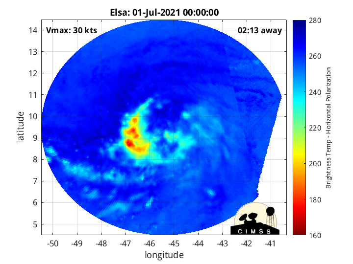
Center appears to be near where I put the red crosshairs on the image below. Could use a longer satellite loop, but microwave has it near 10N and past 50W.

5 likes
-
SFLcane

- S2K Supporter

- Posts: 10281
- Age: 48
- Joined: Sat Jun 05, 2010 1:44 pm
- Location: Lake Worth Florida
Re: ATL: ELSA - Tropical Storm - Discussion
wxman57 wrote:Center appears to be near where I put the red crosshairs on the image below. Could use a longer satellite loop, but microwave has it near 10N and past 50W.
http://wxman57.com/images/Elsa1.JPG
Lol it has begun…
Cover up Elsa!
0 likes
-
InfernoFlameCat

- Category 5
- Posts: 2127
- Age: 22
- Joined: Mon Dec 14, 2020 10:52 am
- Location: Buford, GA
Re: ATL: ELSA - Tropical Storm - Discussion
TallyTracker wrote:Hypercane_Kyle wrote:Shell Mound wrote:Latest HWRF is following the GFS in caving to EC's weaker solution in the Lesser Antilles.
The 06z HWRF and GFS both have hurricanes, whereas the Euro shows a tropical depression.
IMO, you're putting too much in a model that is known to struggle with storms like Elsa & completely missed its genesis too. Remember Laura last year? As well as nearly every storm too?
Regardless of what the models are saying, newly-formed storms typically struggle when the accelerate to 30 mph in the deep tropics. I can’t recall off the top of my head any 40-60 mph tropical storms that accelerated to 30 mph in the MDR and survived.
Well I can’t recall a scenario quite like this one. Also conditions are very favorable so what else might fall apart this will survive. There is an extremely low chance this dissipates within the next 3 days.
0 likes
I am by no means a professional. DO NOT look at my forecasts for official information or make decisions based on what I post.
Goal: to become a registered expert over tropical and subtropical cyclones.
Goal: to become a registered expert over tropical and subtropical cyclones.
-
Hypercane_Kyle
- Category 5
- Posts: 3465
- Joined: Sat Mar 07, 2015 7:58 pm
- Location: Cape Canaveral, FL
Re: ATL: ELSA - Tropical Storm - Discussion
TallyTracker wrote:Hypercane_Kyle wrote:Shell Mound wrote:Latest HWRF is following the GFS in caving to EC's weaker solution in the Lesser Antilles.
The 06z HWRF and GFS both have hurricanes, whereas the Euro shows a tropical depression.
IMO, you're putting too much in a model that is known to struggle with storms like Elsa & completely missed its genesis too. Remember Laura last year? As well as nearly every storm too?
Regardless of what the models are saying, newly-formed storms typically struggle when the accelerate to 30 mph in the deep tropics. I can’t recall off the top of my head any 40-60 mph tropical storms that accelerated to 30 mph in the MDR and survived.
Right now Elsa is moving at 25 mph, this is comparable to both Dorian and Isaias in the MDR.
4 likes
My posts are my own personal opinion, defer to the National Hurricane Center (NHC) and other NOAA products for decision making during hurricane season.
-
AutoPenalti
- Category 5
- Posts: 4091
- Age: 29
- Joined: Mon Aug 17, 2015 4:16 pm
- Location: Ft. Lauderdale, Florida
Re: ATL: ELSA - Tropical Storm - Discussion
Looks very disorganized compared to yesterday, don’t think HWRF will verify.
0 likes
The posts in this forum are NOT official forecasts and should not be used as such. They are just the opinion of the poster and may or may not be backed by sound meteorological data. They are NOT endorsed by any professional institution or STORM2K. For official information, please refer to products from the NHC and NWS.
Model Runs Cheat Sheet:
GFS (5:30 AM/PM, 11:30 AM/PM)
HWRF, GFDL, UKMET, NAVGEM (6:30-8:00 AM/PM, 12:30-2:00 AM/PM)
ECMWF (1:45 AM/PM)
TCVN is a weighted averaged
-
eastcoastFL
- Category 5
- Posts: 3996
- Age: 44
- Joined: Thu Apr 12, 2007 12:29 pm
- Location: Palm City, FL
Re: ATL: ELSA - Tropical Storm - Discussion

2 likes
Personal Forecast Disclaimer:
The posts in this forum are NOT official forecast and should not be used as such. They are just the opinion of the poster and may or may not be backed by sound meteorological data. They are NOT endorsed by any professional institution or storm2k.org. For official information, please refer to the NHC and NWS products.
The posts in this forum are NOT official forecast and should not be used as such. They are just the opinion of the poster and may or may not be backed by sound meteorological data. They are NOT endorsed by any professional institution or storm2k.org. For official information, please refer to the NHC and NWS products.
-
jasons2k

- Storm2k Executive

- Posts: 8290
- Age: 52
- Joined: Wed Jul 06, 2005 12:32 pm
- Location: The Woodlands, TX
Re: ATL: ELSA - Tropical Storm - Discussion
Update from Jeff Lindner:
Tropical Storm Elsa has formed overnight east of the Windward Islands.
Tropical Storm watches and warnings have been issued for portions of the Windward Islands.
Discussion:
Elsa becomes the earliest “E” storm on record surpassing the record set just last year in 2020 by 5 days. The overall organization of the system has improved overnight with banding features having developed over the west and southwest portion of the circulation and pulses of deep convection. Based on the cloud pattern, there is some degree of ENE/E shear over the system, but the very fast forward speed of 22kts is likely helping to negate this shear somewhat. Elsa appears to be a developing tropical storm with a large circulation envelop.
Track:
A strong sub-tropical ridge of high pressure north of Elsa will force the system W to WNW over the next 48-72 hours crossing the Windward Islands in the next 24-36 hours and then across the eastern Caribbean Sea into the central Caribbean Sea over the weekend. Elsa is already moving fast for a tropical system and the forward speed may increase a bit more over the next 24-48 hours. After 72 hours, the tightly clustered track guidance greatly diverge with the GFS, most of its ensembles, the HWRF and HMON showing a track toward central and western Cuba and the SE/E Gulf of Mexico while the ECMWF turns the system northward east of the Bahamas resulting in a very large guidance spread at days 4-5. The ECWMF is very fast and has Elsa near Hispaniola in just 60-66 hours….which seems unlikely. The western edge of the strong sub-tropical ridge over the SW Atlantic will likely erode some late this weekend into early next week due to a mid level trough over the E/SE US so a slowing of the forward motion and turn of Elsa toward the NW is likely. How sharp a turn and where is the question. Current NHC forecast track favors the leftward guidance cluster and has Elsa near Cuba at days 4-5. It should be stated that the track confidence at days 3-5 is lower than average.
Intensity:
Elsa is in a favorable environment for intensification with warm sea surface temperatures and large moisture envelop and mainly light upper level winds although there is likely some weak E/NE shear over the system. Conditions are unusually favorable this far east so early in the season. Once an inner core is able to form and sustained convection develops intensification is likely and NHC brings Elsa to a 60mph TS before reaching the Windward Island. One negative to intensification may be the very fast forward motion which can at times result in the low level center “outrunning” the mid and upper level centers and resulting in a highly disorganized tropical system. This is especially true in the eastern Caribbean Sea where developing tropical systems tend to struggle. After day 3, land interaction with the larger islands of the Greater Antilles could cause some disruption of the system, but it is uncertain how much if any interaction there may be. Guidance is generally fairly aggressive with Elsa with several models showing a hurricane, but given some of the factors listed above, NHC is on the lower side of the guidance envelop and keep Elsa a tropical storm through the period. It would not be surprising if Elsa were to become a hurricane at some point over the next 5 days.
6 likes
-
wxman57
- Moderator-Pro Met
- Posts: 23175
- Age: 68
- Joined: Sat Jun 21, 2003 8:06 pm
- Location: Houston, TX (southwest)
Re: ATL: ELSA - Tropical Storm - Discussion
TallyTracker wrote:
Regardless of what the models are saying, newly-formed storms typically struggle when the accelerate to 30 mph in the deep tropics. I can’t recall off the top of my head any 40-60 mph tropical storms that accelerated to 30 mph in the MDR and survived.
You're not recalling far enough back. The first hurricane I ever forecast was Allen in 1980. It was moving at a solid 25 kts all the way from Africa to the western Caribbean, much of the time as a Cat 5. Only multiple eyewall replacement cycles dropped it occasionally to a Cat 3 in the Caribbean. Back then, we couldn't see much with the very low-res satellite imagery that was printed on thermal paper every 3 hours or so. Models maybe went out 2-3 days, and there was only the MRF (precursor to GFS). I remember a model called the LFM (Limited Fine Mesh). Ah, the good old days...
16 likes
-
eastcoastFL
- Category 5
- Posts: 3996
- Age: 44
- Joined: Thu Apr 12, 2007 12:29 pm
- Location: Palm City, FL
Re: ATL: ELSA - Tropical Storm - Discussion
wxman57 wrote:Center appears to be near where I put the red crosshairs on the image below. Could use a longer satellite loop, but microwave has it near 10N and past 50W.
http://wxman57.com/images/Elsa1.JPG
That looks right. Do you think the center will continue to relocate as convection builds or wanes?
0 likes
Personal Forecast Disclaimer:
The posts in this forum are NOT official forecast and should not be used as such. They are just the opinion of the poster and may or may not be backed by sound meteorological data. They are NOT endorsed by any professional institution or storm2k.org. For official information, please refer to the NHC and NWS products.
The posts in this forum are NOT official forecast and should not be used as such. They are just the opinion of the poster and may or may not be backed by sound meteorological data. They are NOT endorsed by any professional institution or storm2k.org. For official information, please refer to the NHC and NWS products.
-
eastcoastFL
- Category 5
- Posts: 3996
- Age: 44
- Joined: Thu Apr 12, 2007 12:29 pm
- Location: Palm City, FL
Re: ATL: ELSA - Tropical Storm - Discussion
wxman57 wrote:TallyTracker wrote:
Regardless of what the models are saying, newly-formed storms typically struggle when the accelerate to 30 mph in the deep tropics. I can’t recall off the top of my head any 40-60 mph tropical storms that accelerated to 30 mph in the MDR and survived.
You're not recalling far enough back. The first hurricane I ever forecast was Allen in 1980. It was moving at a solid 25 kts all the way from Africa to the western Caribbean, much of the time as a Cat 5. Only multiple eyewall replacement cycles dropped it occasionally to a Cat 3 in the Caribbean. Back then, we couldn't see much with the very low-res satellite imagery that was printed on thermal paper every 3 hours or so. Models maybe went out 2-3 days, and there was only the MRF (precursor to GFS). I remember a model called the LFM (Limited Fine Mesh). Ah, the good old days...
Limited fine mesh? Sounds awful. Would you say forecasting is easier now with all the tools you have? Or does it end up causing more work?
0 likes
Personal Forecast Disclaimer:
The posts in this forum are NOT official forecast and should not be used as such. They are just the opinion of the poster and may or may not be backed by sound meteorological data. They are NOT endorsed by any professional institution or storm2k.org. For official information, please refer to the NHC and NWS products.
The posts in this forum are NOT official forecast and should not be used as such. They are just the opinion of the poster and may or may not be backed by sound meteorological data. They are NOT endorsed by any professional institution or storm2k.org. For official information, please refer to the NHC and NWS products.
-
Shell Mound
- Category 5
- Posts: 2432
- Age: 33
- Joined: Thu Sep 07, 2017 3:39 pm
- Location: St. Petersburg, FL → Scandinavia
Re: ATL: ELSA - Tropical Storm - Discussion
eastcoastFL wrote:Shell Mound wrote:eastcoastFL wrote:
New convection appears to be firing on the NE side now
https://cdn.star.nesdis.noaa.gov/FLOATER/data/AL052021/13/GOES16-AL052021-13-1000x1000.gif?hash=9157
That outer convective band to the NNW of the LLC is arguably just as important, along with the expanding "feathery" cirrus-outflow channel(s) in most quadrants. If isolated convection to the NNW of the LLC grows over time, it could indicate a gradual mixing out of the dry marine inversion. If that is the case and persists, then Elsa would have its best opportunity to exceed expectations, intensity-wise, prior to impacting the Lesser Antilles.
I agree. Today will be an interesting day to watch the evolution of this storm. I’m grateful for the forward speed because without that I think she’d really be hitting hard right now.
Latest imagery suggests that the band to the NNW of the LLC is gradually attempting to expand and "wrap around," while the convective burst to the ESE of the LLC seems to be slowly encroaching on the center. Normally, these two indicators together, along with the impressive outflow evident, would suggest that dry air is moistening and a formative CDO may develop within the next day and a half.
7 likes
CVW / MiamiensisWx / Shell Mound
The posts in this forum are NOT official forecasts and should not be used as such. They are just the opinion of the poster and may or may not be backed by sound meteorological data. They are NOT endorsed by any professional institution or STORM2K. For official information, please refer to products from the NHC and NWS.

Re: ATL: ELSA - Tropical Storm - Discussion
This is where I estimate the LLC to be located, a little further SE from where wxman57 has it.

Last edited by NDG on Thu Jul 01, 2021 7:29 am, edited 1 time in total.
2 likes
-
Weatherwatcher2018
- Tropical Depression

- Posts: 82
- Joined: Wed Sep 26, 2018 4:30 pm
Re: ATL: ELSA - Tropical Storm - Discussion
So with the fast movement, we in Barbados might get a break right?
3 likes

Who is online
Users browsing this forum: No registered users and 28 guests