Unpredictability of Hurricane Intensity Forecasts:

This is the general tropical discussion area. Anyone can take their shot at predicting a storms path.

Moderator: S2k Moderators

Forum rules

The posts in this forum are NOT official forecasts and should not be used as such. They are just the opinion of the poster and may or may not be backed by sound meteorological data. They are NOT endorsed by any professional institution or STORM2K. For official information, please refer to products from the National Hurricane Center and National Weather Service.

Help Support Storm2K
Message
Author
User avatar
Iceresistance
Category 5
Category 5
Posts: 9288
Age: 21
Joined: Sat Oct 10, 2020 9:45 am
Location: Tecumseh, OK/Norman, OK

Re: Unpredictability of Hurricane Intensity Forecasts:

#21 Postby Iceresistance » Sun May 16, 2021 2:51 pm

ncforecaster89 wrote:
Audrey2Katrina wrote:I concur with Shell Mound, and to some degree ncforecaster89 (excepting this part: "Although the winds were still of Cat 2 strength as Zeta moved directly through the city of New Orleans,", as I found NO evidence of Cat 2 winds anywhere in or through New Orleans, not from the weather bureau, not from any televised reporting station. That said I suppose there might have been isolated gusts barely reaching that level, however we bandy about terms like Cat 2 or Cat 3 too much without distinguishing "gusts" from "sustained" and I can assure you New Orleans had NO sustained Cat 2 winds. Given that ncforecaster89 brings a valid point about travelling over the water. I hadn't considered winds over water where there would be considerably less friction from the land. That said, I also agree that from every indication I saw, Sally looked more the viable candidate as a MH than Zeta. I forgot to mention that the report stated landfall for Zeta was near Cocodrie, which is where at least two of my friends were--and they still say no sustained winds of 110 mph or greater hit them. They DID say the surf was (obviously) rough... and the winds "in gusts" probably reached over 110, but having been through genuine Cat 3's before, this one was tame and that's what worries me. People will think that if that was a Cat 3, and they did just fine going through it-- they might think a bigger more powerful Cat 2 is nothing to worry about--when it is! And a bigger more powerful Cat 3 can be devastating along coastal areas. Yes, the winds were obviously around Cat 2 "In Gusts", but storms are classified by sustained winds and not gusts. I was glad to see that at least on my television they made that distinction. I can't post the picture, obviously, but I have one of all the reported highest "gusts" and few of them are mid to high Cat 1, and only Gulfport showed minimal Cat 2.

Zeta was such a non-event for the vast majority down here that I truly worry the young, in particular, will underestimate the next Cat 3 that is a REAL Cat 3 and much bigger, and that could be a fatal mistake. On the other hand, a friend of mine in Gulf Shores who rode out Sally, said that was worse than he remembered from Betsy which we both rode out in our homes back in '65. But I think his memory is fading as I remember seeing Betsy blow a roof off of garage like it was a toy. Ahhh, I digress; but my main point is that Zeta was borderline Cat 2/3 but I don't believe it was a bonafide Cat 3... that's my opinion. We may well talk of not having much better science than what we now have; however I'm sure the same was said of the science we had in 1970. People tend to think they live in a technology that has reached its zenith, --that is until the next level shows up and is a quantum leap forward. I hope so, for the sake of people caught in their paths, as I had a family member killed by Katrina. (He was a first responder.) These monsters (yes even Zeta types) need all the respect we can give them. Tropical Storms can be killers and this was, to be sure, much worse than a tropical storm. They may be intriguing and even fun to view, plot, follow, and discuss; but they are, in the final analysis, very dangerous. I hold hope for improvement as better still in years to come, in forecasting and analyzing these killers for the sake of humanity.


I agree with your post, but need to clarify that I didn’t say or mean to imply that Zeta brought Cat 2 winds to New Orleans, as it moved directly over the city. Those Cat two winds were certainly just to the E of the city. I’d estimate that no part of the city experienced wind gusts even reaching 100 mph. To your point, N.O. likely had a Cat 1 hurricane impact.


Also want to mention that Hurricane Zeta was moving very fast!
1 likes   
Bill 2015 & Beta 2020

Winter 2020-2021 :cold:

All observations are in Tecumseh, OK unless otherwise noted.

Winter posts are focused mainly for Oklahoma & Texas.

Take any of my forecasts with a grain of salt, refer to the NWS, SPC, and NHC for official information

Never say Never with weather! Because ANYTHING is possible!

ncforecaster89
Tropical Storm
Tropical Storm
Posts: 233
Age: 55
Joined: Sat Oct 20, 2018 12:32 pm
Contact:

Re: Unpredictability of Hurricane Intensity Forecasts:

#22 Postby ncforecaster89 » Sun May 16, 2021 3:10 pm

Iceresistance wrote:
ncforecaster89 wrote:
Audrey2Katrina wrote:I concur with Shell Mound, and to some degree ncforecaster89 (excepting this part: "Although the winds were still of Cat 2 strength as Zeta moved directly through the city of New Orleans,", as I found NO evidence of Cat 2 winds anywhere in or through New Orleans, not from the weather bureau, not from any televised reporting station. That said I suppose there might have been isolated gusts barely reaching that level, however we bandy about terms like Cat 2 or Cat 3 too much without distinguishing "gusts" from "sustained" and I can assure you New Orleans had NO sustained Cat 2 winds. Given that ncforecaster89 brings a valid point about travelling over the water. I hadn't considered winds over water where there would be considerably less friction from the land. That said, I also agree that from every indication I saw, Sally looked more the viable candidate as a MH than Zeta. I forgot to mention that the report stated landfall for Zeta was near Cocodrie, which is where at least two of my friends were--and they still say no sustained winds of 110 mph or greater hit them. They DID say the surf was (obviously) rough... and the winds "in gusts" probably reached over 110, but having been through genuine Cat 3's before, this one was tame and that's what worries me. People will think that if that was a Cat 3, and they did just fine going through it-- they might think a bigger more powerful Cat 2 is nothing to worry about--when it is! And a bigger more powerful Cat 3 can be devastating along coastal areas. Yes, the winds were obviously around Cat 2 "In Gusts", but storms are classified by sustained winds and not gusts. I was glad to see that at least on my television they made that distinction. I can't post the picture, obviously, but I have one of all the reported highest "gusts" and few of them are mid to high Cat 1, and only Gulfport showed minimal Cat 2.

Zeta was such a non-event for the vast majority down here that I truly worry the young, in particular, will underestimate the next Cat 3 that is a REAL Cat 3 and much bigger, and that could be a fatal mistake. On the other hand, a friend of mine in Gulf Shores who rode out Sally, said that was worse than he remembered from Betsy which we both rode out in our homes back in '65. But I think his memory is fading as I remember seeing Betsy blow a roof off of garage like it was a toy. Ahhh, I digress; but my main point is that Zeta was borderline Cat 2/3 but I don't believe it was a bonafide Cat 3... that's my opinion. We may well talk of not having much better science than what we now have; however I'm sure the same was said of the science we had in 1970. People tend to think they live in a technology that has reached its zenith, --that is until the next level shows up and is a quantum leap forward. I hope so, for the sake of people caught in their paths, as I had a family member killed by Katrina. (He was a first responder.) These monsters (yes even Zeta types) need all the respect we can give them. Tropical Storms can be killers and this was, to be sure, much worse than a tropical storm. They may be intriguing and even fun to view, plot, follow, and discuss; but they are, in the final analysis, very dangerous. I hold hope for improvement as better still in years to come, in forecasting and analyzing these killers for the sake of humanity.


I agree with your post, but need to clarify that I didn’t say or mean to imply that Zeta brought Cat 2 winds to New Orleans, as it moved directly over the city. Those Cat two winds were certainly just to the E of the city. I’d estimate that no part of the city experienced wind gusts even reaching 100 mph. To your point, N.O. likely had a Cat 1 hurricane impact.


Also want to mention that Hurricane Zeta was moving very fast!


Exactly, and that’s the main reason the winds in the NW quadrant were substantially less than those in the NE...far more so than is typical for a northward moving hurricane.

On a similar note, I find it amazing that many (even well known Mets) wrongly tell their viewers that you add the forward speed of the hurricane to the MSW listed in the NHC advisories for the RF quadrant...not understanding, seemingly...that those MSWs are the absolute highest estimated to be found anywhere within the eyewall. The translation speed has already augmented the winds being measured by RECON.
2 likes   

User avatar
Audrey2Katrina
Category 5
Category 5
Posts: 4252
Age: 75
Joined: Fri Dec 23, 2005 10:39 pm
Location: Metaire, La.

Re: Unpredictability of Hurricane Intensity Forecasts:

#23 Postby Audrey2Katrina » Sun May 16, 2021 10:50 pm

ncforecaster89 wrote:
Iceresistance wrote:
ncforecaster89 wrote:
I agree with your post, but need to clarify that I didn’t say or mean to imply that Zeta brought Cat 2 winds to New Orleans, as it moved directly over the city. Those Cat two winds were certainly just to the E of the city. I’d estimate that no part of the city experienced wind gusts even reaching 100 mph. To your point, N.O. likely had a Cat 1 hurricane impact.


Also want to mention that Hurricane Zeta was moving very fast!


Exactly, and that’s the main reason the winds in the NW quadrant were substantially less than those in the NE...far more so than is typical for a northward moving hurricane.

On a similar note, I find it amazing that many (even well known Mets) wrongly tell their viewers that you add the forward speed of the hurricane to the MSW listed in the NHC advisories for the RF quadrant...not understanding, seemingly...that those MSWs are the absolute highest estimated to be found anywhere within the eyewall. The translation speed has already augmented the winds being measured by RECON.


I appreciate that information you added at the end. This only confirms me in my belief, (As most of the folks I know were IN the NE quadrant) that it was never sustained Cat 2 over the metro NO area. All that said, NO storm, is a storm to be taken lightly. I'm afraid too many are doing just that after how little Zeta affected our area--I did tell everyone I know that the forward speed reduces impact and damage. However I still hold to my beliefs that her winds were over-figured.

A2K
0 likes   
Flossy 56 Audrey 57 Hilda 64* Betsy 65* Camille 69* Edith 71 Carmen 74 Bob 79 Danny 85 Elena 85 Juan 85 Florence 88 Andrew 92*, Opal 95, Danny 97, Georges 98*, Isidore 02, Lili 02, Ivan 04, Cindy 05*, Dennis 05, Katrina 05*, Gustav 08*, Isaac 12*, Nate 17, Barry 19, Cristobal 20, Marco, 20, Sally, 20, Zeta 20*, Claudette 21 IDA* 21 Francine *24

User avatar
Audrey2Katrina
Category 5
Category 5
Posts: 4252
Age: 75
Joined: Fri Dec 23, 2005 10:39 pm
Location: Metaire, La.

Re: Unpredictability of Hurricane Intensity Forecasts:

#24 Postby Audrey2Katrina » Sun May 16, 2021 10:56 pm

Iceresistance wrote:Also want to mention that Hurricane Zeta was moving very fast!"


No argument there, and as I previously stated, that would affect the damage and overall impact--but it would NOT affect the windspeeds measured. If there were Cat 2 winds--they'd have been measured somewhere-- they weren't. The NHC's own final analysis states the highest winds were those in Golden Meadow... which were actually high-end Cat 1. Do I think some totally isolated areas might have gotten into low range Cat 2... of course it's probable. But overwhelmingly, while news reports kept insisting the top wind were 110 mph sustained well into Mississippi, the fact remains that was just not true. People need to know they didn't experience anything remotely winds that close to a Cat 3 level. Nowhere further inland had anything but Cat 1 winds, so they can appreciate what a slower moving, and real Cat 2 or 3 could do--which would've been very much worse.

A2K
0 likes   
Flossy 56 Audrey 57 Hilda 64* Betsy 65* Camille 69* Edith 71 Carmen 74 Bob 79 Danny 85 Elena 85 Juan 85 Florence 88 Andrew 92*, Opal 95, Danny 97, Georges 98*, Isidore 02, Lili 02, Ivan 04, Cindy 05*, Dennis 05, Katrina 05*, Gustav 08*, Isaac 12*, Nate 17, Barry 19, Cristobal 20, Marco, 20, Sally, 20, Zeta 20*, Claudette 21 IDA* 21 Francine *24

User avatar
Audrey2Katrina
Category 5
Category 5
Posts: 4252
Age: 75
Joined: Fri Dec 23, 2005 10:39 pm
Location: Metaire, La.

Re: Unpredictability of Hurricane Intensity Forecasts:

#25 Postby Audrey2Katrina » Sun May 16, 2021 11:03 pm

Shell Mound wrote:
Audrey2Katrina wrote:I concur with Shell Mound, and to some degree ncforecaster89 (excepting this part: "Although the winds were still of Cat 2 strength as Zeta moved directly through the city of New Orleans,", as I found NO evidence of Cat 2 winds anywhere in or through New Orleans, not from the weather bureau, not from any televised reporting station. That said I suppose there might have been isolated gusts barely reaching that level, however we bandy about terms like Cat 2 or Cat 3 too much without distinguishing "gusts" from "sustained" and I can assure you New Orleans had NO sustained Cat 2 winds. Given that ncforecaster89 brings a valid point about travelling over the water. I hadn't considered winds over water where there would be considerably less friction from the land. That said, I also agree that from every indication I saw, Sally looked more the viable candidate as a MH than Zeta. I forgot to mention that the report stated landfall for Zeta was near Cocodrie, which is where at least two of my friends were--and they still say no sustained winds of 110 mph or greater hit them. They DID say the surf was (obviously) rough... and the winds "in gusts" probably reached over 110, but having been through genuine Cat 3's before, this one was tame and that's what worries me. People will think that if that was a Cat 3, and they did just fine going through it-- they might think a bigger more powerful Cat 2 is nothing to worry about--when it is! And a bigger more powerful Cat 3 can be devastating along coastal areas. Yes, the winds were obviously around Cat 2 "In Gusts", but storms are classified by sustained winds and not gusts. I was glad to see that at least on my television they made that distinction. I can't post the picture, obviously, but I have one of all the reported highest "gusts" and few of them are mid to high Cat 1, and only Gulfport showed minimal Cat 2.

Zeta was such a non-event for the vast majority down here that I truly worry the young, in particular, will underestimate the next Cat 3 that is a REAL Cat 3 and much bigger, and that could be a fatal mistake. On the other hand, a friend of mine in Gulf Shores who rode out Sally, said that was worse than he remembered from Betsy which we both rode out in our homes back in '65. But I think his memory is fading as I remember seeing Betsy blow a roof off of garage like it was a toy. Ahhh, I digress; but my main point is that Zeta was borderline Cat 2/3 but I don't believe it was a bonafide Cat 3... that's my opinion. We may well talk of not having much better science than what we now have; however I'm sure the same was said of the science we had in 1970. People tend to think they live in a technology that has reached its zenith, --that is until the next level shows up and is a quantum leap forward. I hope so, for the sake of people caught in their paths, as I had a family member killed by Katrina. (He was a first responder.) These monsters (yes even Zeta types) need all the respect we can give them. Tropical Storms can be killers and this was, to be sure, much worse than a tropical storm. They may be intriguing and even fun to view, plot, follow, and discuss; but they are, in the final analysis, very dangerous. I hold hope for improvement as better still in years to come, in forecasting and analyzing these killers for the sake of humanity.

On another note, as far as Audrey (1957) is concerned, the Best Track Committee officially determined that Audrey exhibited double wind maxima during landfall: an outer RMW of ~30 n mi and an inner of ~15 n mi. Radar fixes from aircraft suggested that landfall occurred at 13:30 UTC on 27 June 1957. Based on this map, the outer RMW was responsible for a peak storm tide of 13.9 ft at the mouth of the Mermentau River, along Lower Mud Lake near Grand Chenier. Based on complete records of surface weather data from Lake Charles and Port Arthur, TX, the location of the landfall can be calculated rather accurately, given that aircraft and radar were also available, along with records of wind, MSLP, and storm tide. So despite being embedded in low environmental pressures, Audrey clearly retained a rather small inner core at landfall, along with an outer, or concentric, eyewall. It is noted that a report from the National Hurricane Research Project (NHRP) estimated a possible MSLP in Audrey ranging from 919 to 960 mb at landfall, with the best estimate calculated to be 946 mb, but there seems to have been a rather large degree of uncertainty involved. A ship reported an unconfirmed reading of 924.5 mb and four oil-tender barges, each equipped with an anemometer (height: 65 ft / ~20 m), recorded peak gusts ranging from 104 to 130 kt, with two of the barges separately registering peak gusts of 126 kt. The positions of these barges and the ship relative to the centre are not known with precision, but the NHRP report notes that the barges were adrift to the southeast of Cameron, so they would have experienced the outer RMW, if not the inner, on the eastern side of the storm. Note that the inner RMW would have likely been stronger than the outer, so the barges might have just missed the peak winds in the strongest quadrant. On the western side, the U.S. Coast Guard Station at Sabine, TX, recorded a sustained wind of 90 kt from the southwest at 15:00 UTC, the station having full marine exposure at the standard (10-m) elevation. This is considerably higher than the isoline charts in the NHRP report show for this location. Taken together, the evidence suggests that Audrey may need to be revisited in the future and potentially upgraded back to Cat-4 status, at the very least


I agree with everything you stated there. Well said! 8-)
0 likes   
Flossy 56 Audrey 57 Hilda 64* Betsy 65* Camille 69* Edith 71 Carmen 74 Bob 79 Danny 85 Elena 85 Juan 85 Florence 88 Andrew 92*, Opal 95, Danny 97, Georges 98*, Isidore 02, Lili 02, Ivan 04, Cindy 05*, Dennis 05, Katrina 05*, Gustav 08*, Isaac 12*, Nate 17, Barry 19, Cristobal 20, Marco, 20, Sally, 20, Zeta 20*, Claudette 21 IDA* 21 Francine *24

Shell Mound
Category 5
Category 5
Posts: 2434
Age: 32
Joined: Thu Sep 07, 2017 3:39 pm
Location: St. Petersburg, FL → Scandinavia

Re: Unpredictability of Hurricane Intensity Forecasts:

#26 Postby Shell Mound » Mon May 17, 2021 3:38 am

Shell Mound wrote:
ncforecaster89 wrote:
Audrey2Katrina wrote:
As one who went through Zeta completely (eye passed directly over--I remember that 10-15 minute lull - then winds from opposite direction) I gotta believe they'll revisit it one day too-- I may not even be around (after all they reclassified Audrey over 50 years later) but you'll NEVER convince me that storm (Zeta) was a Cat 3--and I can assure you it wasn't a Cat 2 passing over New Orleans. I have many friends who live down near Cocodrie who rode it out, the storm was just not as powerful as they said it was. I am certain that we never even had strong Cat 1 winds WITH the eye passing over us, and I have a picture from my TV set (never lost power--and I know most people in the area DID lose it, but for some reason, and I thank God, I never lost the power) I watched as they showed all the highest sustained and highest gusts on TV,... not a single GUST shown was over Cat 1 status and the NHC report itself states that the highest sustained winds after landfall were in Golden Meadow, I believe, and those were CAT ! winds. This was no Cat 3 storm--or if they're going to say it was, then they need to re-re-evaluate Audrey which was WAY worse than this thing.

A2K


Hi A2K! I relocated from the NE eyewall near Jesuit Bend, La and drove NNW through the eyewall into New Orleans as the peak was hitting the city. Like you, I wasn’t that impressed, relatively speaking, as the winds were likely no greater than 90 mph at the most. That said, the winds were definitely exceeding 100 mph (in gusts) as I drove back NNE over Lake Ponchartrain towards the Mississippi coast. Those winds out over the water and on the bridge were possibly the most extreme velocity I have ever encountered in a vehicle.

As Crazy stated, the Cat 3 winds of Zeta were only felt in a very small area right at the coast to the E of where the eye crossed the shoreline. Although the winds were still of Cat 2 strength as Zeta moved directly through the city of New Orleans, the stronger winds were still well to the east as the eye pushed towards the MS coastline.

I will add that Zeta was one of the weaker, if not the weakest, borderline Cat 2/3 eyewall experiences of my chase career (dating back to 1989). In contrast, Sally provided the most extreme eyewall experiences of my career for a borderline Cat 2/3 encounter.

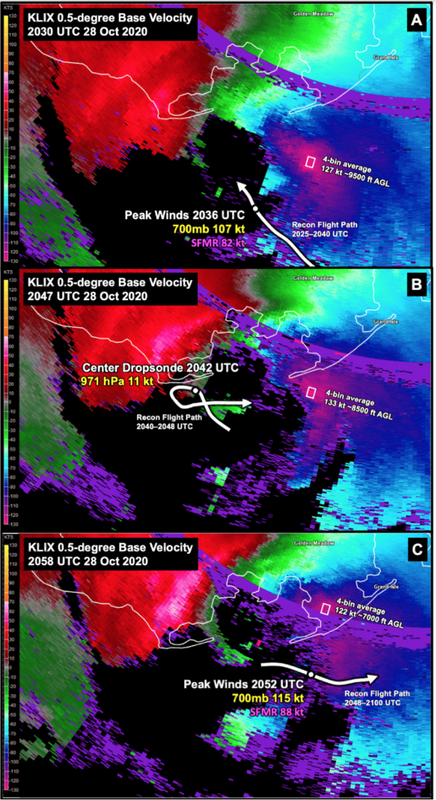
Officially, Zeta made landfall at 29.2°N 90.6°W at 21:00 UTC on 28 October 2021. Based on CIMSS’s SATCON, the peak MSW derived from a consensus of satellite estimates was 96 kt at 21:20 UTC on 28 October, right around the time of landfall. For comparison: Sally made landfall at 30.3°N 87.7°W at 09:45 UTC on 16 September 2021. Peak SATCON-derived estimates of the MSW were 104 kt at 06:50 UTC on 16 September. Estimates around the time of landfall averaged 99 kt. So it is interesting to note that satellite estimates provided more support for Sally being a MH than Zeta. SATCON alone supported a MSW of 95 kt at LF for Zeta and 100 kt at LF for Sally, with Sally actually having peaked at 105 kt several hours before LF, while offshore. However, note that the observation of 98 kt from Ingram Bayou, AL, during Sally was inside the RMW, did experience the strongest (easterly) quadrant (the eye made landfall just to the west, near Gulf Shores), and had proper marine exposure along a bayou while sited at 18 m (standard elevation is 10 m). So in that case the observation may well have been representative of the peak winds in Sally and supported 95 kt at LF. Regardless, SATCON for Zeta was clearly supporting a higher MSW at landfall than local surface observations suggested, given the negligible difference between 95 and 100 kt.

Image
This image was taken from p. 46 of Zeta’s TCR. It does indicate, based on extrapolation, that the peak radar-derived winds passed over the marshes to the east of Leeville and Golden Meadow, so Golden Meadow clearly missed the MSW in the eastern eyewall. The image also confirms that the reconnaissance pass closest to (during) the time of landfall missed the peak winds in the eastern quadrant, which had already moved ashore very close to Port Fourchon. Note that the peak winds evidently occurred within a very small area to the east-southeast of the eye. Additionally, note that the peak flight-level (700-mb) winds of 119 kt reported by aircraft occurred in the northeastern quadrant at 18:43 UTC, more than two hours prior to landfall, and since Zeta was moving north-northeastward at that time, the peak MSW would have occurred to the east-southeast of the eye, so the 119-kt observation from reconnaissance likely failed to sample Zeta’s MSW at the time, given its position in the northeastern rather than southeastern quadrant. A better way to estimate Zeta’s MSW would be to compare radar velocities over Golden Meadow simultaneously with the peak surface winds observed there. If the radar-derived velocities correspond well to the observation of 82 kt, then that would lend more confidence to the 100-kt estimate in the TCR at the time of Zeta’s landfall.
0 likes   
CVW / MiamiensisWx / Shell Mound
The posts in this forum are NOT official forecasts and should not be used as such. They are just the opinion of the poster and may or may not be backed by sound meteorological data. They are NOT endorsed by any professional institution or STORM2K. For official information, please refer to products from the NHC and NWS.


Return to “Talkin' Tropics”

Who is online

Users browsing this forum: Ivanhater, ouragans, Steve H. and 26 guests