#1496 Postby TheProfessor » Sat Jan 09, 2021 11:34 am
Ntxw wrote:TheProfessor wrote:txtwister78 wrote:https://images.weatherbell.com/model/nbm-conus/tx/total_snow_10to1/1610193600/1610323200-HTFta7NgTzQ.png 12z Blended model guidance snowfall totals. I also think it's important to recognize when looking at snowfall totals (I believe someone mentioned this yesterday) that the maps assume a 10:1 ratio and that isn't the case always so what you see "predicted" on the model doesn't always occur in real time. EWX also mentioned this in the early morning discussion stating "caution should be used when viewing total snowfall accumulation of individual models runs
online, as they can show a 10:1 snow to liquid ratio, not expected for this event, and also not capture the microphysics well"
Snow ratios are very important to talk about. Now the NWS probably isn't looking at Kuchera (I've seen a Wilmington, OH forecaster laugh at that for some reason even though it's just reading the models sampled sounding and converting that into snow ratios.) but Kuchera on both the GFS and 0z CMC shows very poor ratios for the Metroplex, especially the northern Metro. Even in the jackpot areas the CMC and GFS are showing 7/8-1 ratios. It's not until after the event around 12z Monday when the better snow ratios occur. I wouldn't call this a failure mode per say, but it does make the 10-1 maps misleading.
10:1 maps in my opinion are only good for highlighting potential coverage and how much can come out of the sky, nothing about actual accumulation. There are so many other factors in play, but one thing I will say is this so unusual in that the air above is much colder than our typical events in North Texas with such a set up. It's usually borderline at 850mb so ratios may be higher liquid-dendritic growth. Even 2010 we were barely cold enough above. 500mb temps here is -25 to -27C.
850s are cold, but not cold enough to be in the DGZ. I've been going through some Skew-ts and the DGZs are pretty shallow on both global and mesoscale models. In some cases the DGZ is also a bit dry (CMC). Now assuming some of the models are too warm at the surface, then a good estimate for snow ratios would be nearby areas where the models have surface temps near freezing and similar DGZs. It would not surprise me if most of DFW saw snow ratios of 6-1 to 8-1. The higher snow ratios will be to that south closer to the low where there are better dynamics. DFW really needs that low further north to get in on the good dynamics. If I had to issue a widespread forecast for DFW I'd say 1-3" of snow with locally higher accumulations to the south. If the models happen to be too dry, then it's possible that gets bumped up to 3-6" so we'll see what upper air analysis shows us on Sunday.
3 likes
An alumnus of The Ohio State University.
Your local National Weather Service office is your best source for weather information.
 The posts in this forum are NOT official forecast and should not be used as such. They are just the opinion of the poster and may or may not be backed by sound meteorological data. They are NOT endorsed by any professional institution or


 this is ridiculous
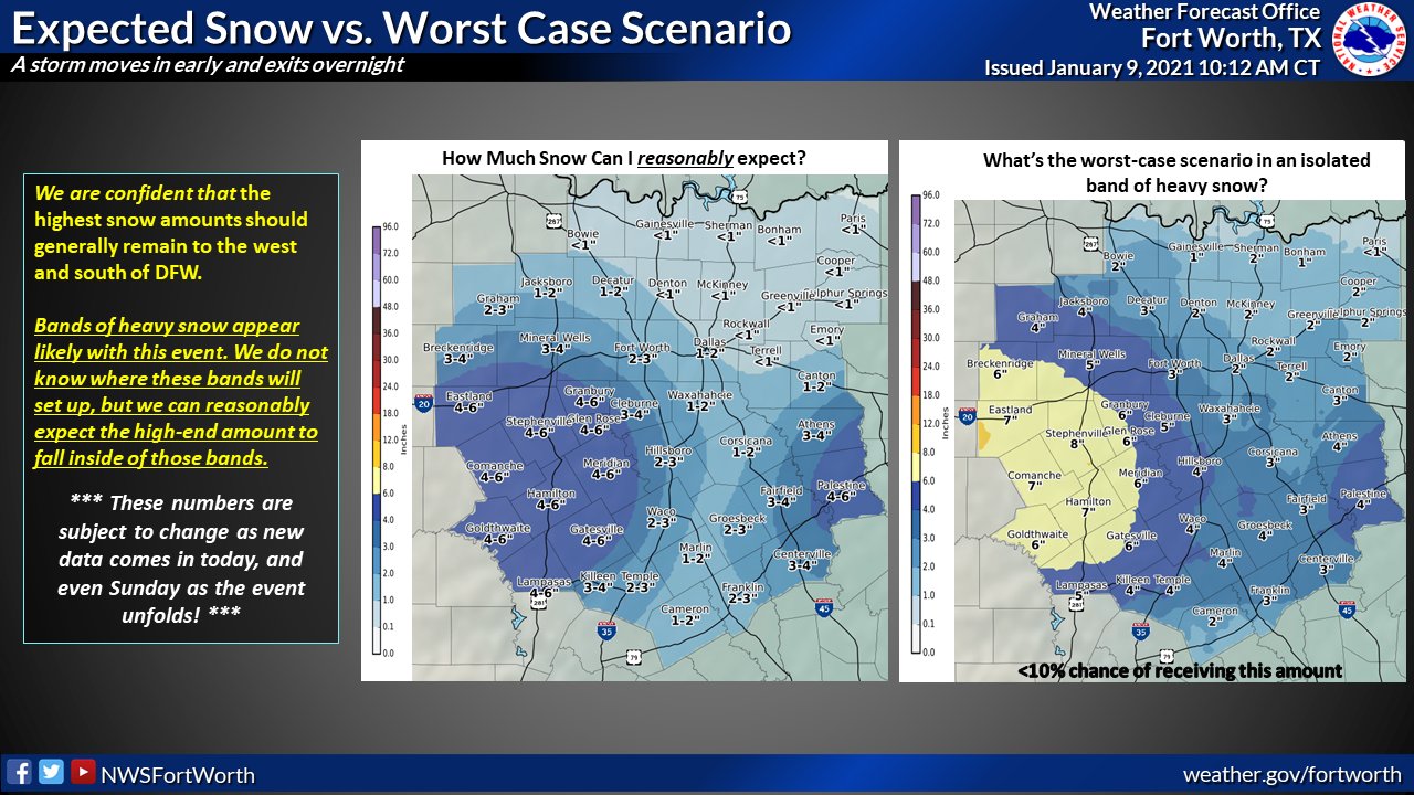
