Lack of SFMR readings of 140 knots were the reason why Eta wasn't upgraded to Cat 5. Iota definitely appears to have become one per recon data.
I'm not sure what's more absurd, the fact we're looking at a Category 5 in November or the fact we're looking at Category 5 Hurricane Iota.
ATL: IOTA - Remnants - Discussion
Moderator: S2k Moderators
-
Hypercane_Kyle

- Category 5

- Posts: 3465
- Joined: Sat Mar 07, 2015 7:58 pm
- Location: Cape Canaveral, FL
Re: ATL: IOTA - Hurricane - Discussion
8 likes
My posts are my own personal opinion, defer to the National Hurricane Center (NHC) and other NOAA products for decision making during hurricane season.

Re: ATL: IOTA - Hurricane - Discussion
Recon dives back for a NE-SW pass. The next update in 10 minutes or otherwise the one afterwards in 20 minutes should have a new center pass.
Last edited by kevin on Mon Nov 16, 2020 8:11 am, edited 1 time in total.
0 likes
-
ElectricStorm

- Category 5
- Posts: 5141
- Age: 25
- Joined: Tue Aug 13, 2019 11:23 pm
- Location: Norman, OK
Re: ATL: IOTA - Hurricane - Discussion
Recon heading in for next pass
0 likes
B.S Meteorology, University of Oklahoma '25
Please refer to the NHC, NWS, or SPC for official information.
Please refer to the NHC, NWS, or SPC for official information.


Re: ATL: IOTA - Hurricane - Discussion
Hypercane_Kyle wrote:Lack of SFMR readings of 140 knots were the reason why Eta wasn't upgraded to Cat 5. Iota definitely appears to have become one per recon data.
I'm not sure what's more absurd, the fact we're looking at a Category 5 in November or the fact we're looking at Category 5 Hurricane Iota.
I think it’s just as or even more absurd that Hurricanes Eta and Iota in NOVEMBER both have strong arguments for peaking as a Cat 5.
7 likes
Irene '11 Sandy '12 Hermine '16 5/15/2018 Derecho Fay '20 Isaias '20 Elsa '21 Henri '21 Ida '21
I am only a meteorology enthusiast who knows a decent amount about tropical cyclones. Look to the professional mets, the NHC, or your local weather office for the best information.
I am only a meteorology enthusiast who knows a decent amount about tropical cyclones. Look to the professional mets, the NHC, or your local weather office for the best information.
-
Hypercane_Kyle
- Category 5
- Posts: 3465
- Joined: Sat Mar 07, 2015 7:58 pm
- Location: Cape Canaveral, FL
Re: ATL: IOTA - Hurricane - Discussion
Pic for historical purposes.

6 likes
My posts are my own personal opinion, defer to the National Hurricane Center (NHC) and other NOAA products for decision making during hurricane season.

Re: ATL: IOTA - Hurricane - Discussion
Here comes the pass we all thought we were getting with Eta...
0 likes
Igor 2010, Sandy 2012, Fay 2014, Gonzalo 2014, Joaquin 2015, Nicole 2016, Humberto 2019, Imelda 2025
I am only a tropical weather enthusiast. My predictions are not official and may or may not be backed by sound meteorological data. For official information, please refer to the NHC and NWS products.
I am only a tropical weather enthusiast. My predictions are not official and may or may not be backed by sound meteorological data. For official information, please refer to the NHC and NWS products.
-
CyclonicFury

- Category 5
- Posts: 2032
- Age: 27
- Joined: Sun Jul 02, 2017 12:32 pm
- Location: NC
- Contact:
Re: ATL: IOTA - Hurricane - Discussion
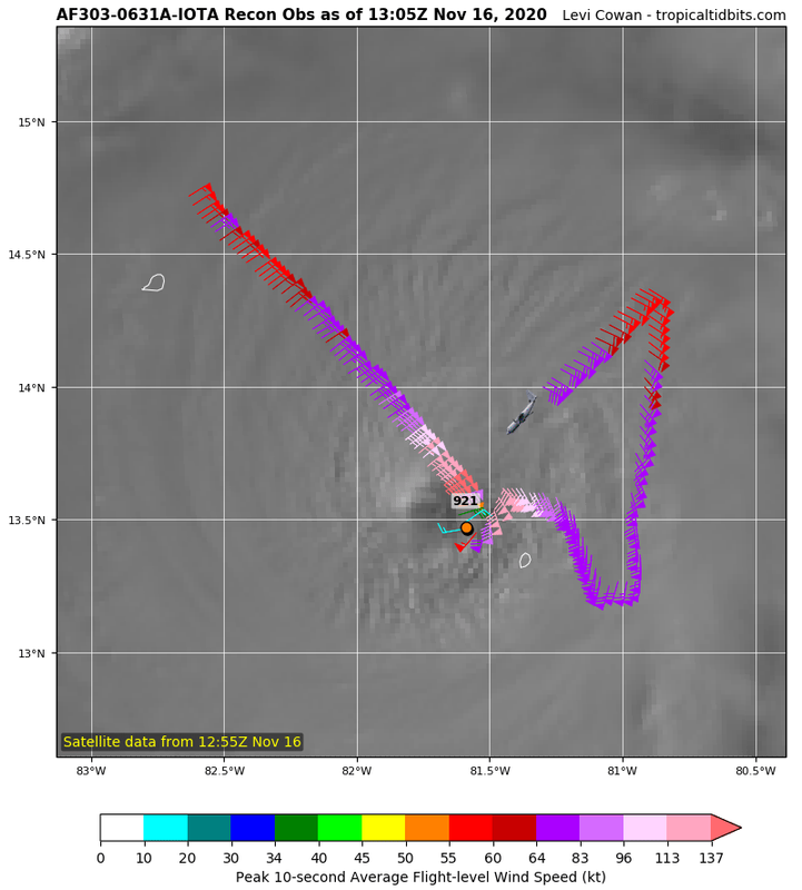
I suspect NHC is looking for a blend of 700 mb flight-level winds (at a 90% reduction) and SFMR wind data to blend to upgrade to Category 5. Right now the peak FL wind is 147 kt, and the peak SFMR wind is 140 kt. Blend the two and it averages out to 136.15 kt, which is closer to 135 kt than 140 kt (but actually converts to 156.5 mph, which would round up to 157 mph - the start of Category 5.)
Iota is extremely close to Category 5 (and IMO, it may have a better argument than Matthew or Lorenzo).
Iota is extremely close to Category 5 (and IMO, it may have a better argument than Matthew or Lorenzo).
0 likes
NCSU B.S. in Meteorology Class of 2021. Tropical weather blogger at http://www.cyclonicfury.com. My forecasts and thoughts are NOT official, for official forecasts please consult the National Hurricane Center.
Re: ATL: IOTA - Hurricane - Discussion
The two 'big ones' this season were both in November. This season has redefined the idea of the Atlantic late season, I never imagined something like this would be possible (not just Iota but all the late season activity this year).
6 likes
-
cycloneye

- Admin

- Posts: 149283
- Age: 69
- Joined: Thu Oct 10, 2002 10:54 am
- Location: San Juan, Puerto Rico
Re: ATL: IOTA - Hurricane - Discussion
0 likes
Visit the Caribbean-Central America Weather Thread where you can find at first post web cams,radars
and observations from Caribbean basin members Click Here
and observations from Caribbean basin members Click Here
Re: ATL: IOTA - Hurricane - Discussion
Looks like we have to wait for one more 10 minute update for the true center pass, 925.2 mbar but still 72 kt SFMR.
0 likes
-
Hypercane_Kyle
- Category 5
- Posts: 3465
- Joined: Sat Mar 07, 2015 7:58 pm
- Location: Cape Canaveral, FL
Re: ATL: IOTA - Hurricane - Discussion
NE quad looks like it's the weakest. That's consistent with what we saw last night.
0 likes
My posts are my own personal opinion, defer to the National Hurricane Center (NHC) and other NOAA products for decision making during hurricane season.


Re: ATL: IOTA - Hurricane - Discussion
Looks like they couldn't launch a dropsonde on the first pass in the eye.
Apparently going for one now.
Apparently going for one now.
0 likes
-
supercane4867
- Category 5
- Posts: 4966
- Joined: Wed Nov 14, 2012 10:43 am
Re: ATL: IOTA - Hurricane - Discussion
CyclonicFury wrote:I suspect NHC is looking for a blend of 700 mb flight-level winds (at a 90% reduction) and SFMR wind data to blend to upgrade to Category 5. Right now the peak FL wind is 147 kt, and the peak SFMR wind is 140 kt. Blend the two and it averages out to 136.15 kt, which is closer to 135 kt than 140 kt (but actually converts to 156.5 mph, which would round up to 157 mph - the start of Category 5.)
Iota is extremely close to Category 5 (and IMO, it may have a better argument than Matthew or Lorenzo).
My question is that, if this is a CAT4 with 115kt SFMR and FL winds slightly lower than the CAT4 threshold the NHC would likely still upgrade it to a 4 as we saw in many cases historically. Why does the advancement from 4 to a 5 always get special treatment? It just seems nonsensical to me.
1 likes
-
ElectricStorm
- Category 5
- Posts: 5141
- Age: 25
- Joined: Tue Aug 13, 2019 11:23 pm
- Location: Norman, OK
Re: ATL: IOTA - Hurricane - Discussion
Final T is now at 7.0. Not seeing much that suggests it's not a Cat 5 at this point considering it's likely still strengthening
0 likes
B.S Meteorology, University of Oklahoma '25
Please refer to the NHC, NWS, or SPC for official information.
Please refer to the NHC, NWS, or SPC for official information.
-
Hypercane_Kyle
- Category 5
- Posts: 3465
- Joined: Sat Mar 07, 2015 7:58 pm
- Location: Cape Canaveral, FL
Re: ATL: IOTA - Hurricane - Discussion
SFMR of 140 knots was what upgraded Matthew. If the NHC is to be consistent, then they should upgrade Iota IMO.
Last edited by Hypercane_Kyle on Mon Nov 16, 2020 8:21 am, edited 1 time in total.
0 likes
My posts are my own personal opinion, defer to the National Hurricane Center (NHC) and other NOAA products for decision making during hurricane season.
Re: ATL: IOTA - Hurricane - Discussion
supercane4867 wrote:CyclonicFury wrote:I suspect NHC is looking for a blend of 700 mb flight-level winds (at a 90% reduction) and SFMR wind data to blend to upgrade to Category 5. Right now the peak FL wind is 147 kt, and the peak SFMR wind is 140 kt. Blend the two and it averages out to 136.15 kt, which is closer to 135 kt than 140 kt (but actually converts to 156.5 mph, which would round up to 157 mph - the start of Category 5.)
Iota is extremely close to Category 5 (and IMO, it may have a better argument than Matthew or Lorenzo).
My question is that, if this is a CAT4 with 115kt SFMR and FL winds slightly lower than the CAT4 threshold the NHC would likely still upgrade it to a 4 as we saw in many cases historically. Why does the advancement from 4 to a 5 always get special treatment? It just seems nonsensical to me.
Yes, this has always annoyed me. NHC has no problem upgrading from cat 1 to cat 2, or cat 3 to cat 4, but the upgrade to a 5 seems to require so much more data and evidence. That's not how science is supposed to work.
1 likes
Igor 2010, Sandy 2012, Fay 2014, Gonzalo 2014, Joaquin 2015, Nicole 2016, Humberto 2019, Imelda 2025
I am only a tropical weather enthusiast. My predictions are not official and may or may not be backed by sound meteorological data. For official information, please refer to the NHC and NWS products.
I am only a tropical weather enthusiast. My predictions are not official and may or may not be backed by sound meteorological data. For official information, please refer to the NHC and NWS products.
-
CyclonicFury
- Category 5
- Posts: 2032
- Age: 27
- Joined: Sun Jul 02, 2017 12:32 pm
- Location: NC
- Contact:
Re: ATL: IOTA - Hurricane - Discussion
supercane4867 wrote:CyclonicFury wrote:I suspect NHC is looking for a blend of 700 mb flight-level winds (at a 90% reduction) and SFMR wind data to blend to upgrade to Category 5. Right now the peak FL wind is 147 kt, and the peak SFMR wind is 140 kt. Blend the two and it averages out to 136.15 kt, which is closer to 135 kt than 140 kt (but actually converts to 156.5 mph, which would round up to 157 mph - the start of Category 5.)
NHC has stated that the reliability of SFMR at extreme intensities is in question.
Iota is extremely close to Category 5 (and IMO, it may have a better argument than Matthew or Lorenzo).
My question is that, if this is a CAT4 with 115kt SFMR and FL winds slightly lower than the CAT4 threshold the NHC would likely still upgrade it to a 4 as we saw in many cases historically. Why does the advancement from 4 to a 5 always get special treatment? It just seems nonsensical to me.
0 likes
NCSU B.S. in Meteorology Class of 2021. Tropical weather blogger at http://www.cyclonicfury.com. My forecasts and thoughts are NOT official, for official forecasts please consult the National Hurricane Center.
Who is online
Users browsing this forum: No registered users and 21 guests