ATL: ETA - Post-Tropical - Discussion

Moderator: S2k Moderators

Message
Author
User avatar
eastcoastFL
Category 5
Category 5
Posts: 3901
Age: 43
Joined: Thu Apr 12, 2007 12:29 pm
Location: Palm City, FL

Re: ATL: ETA - Tropical Storm - Discussion

#3181 Postby eastcoastFL » Sat Nov 07, 2020 1:26 pm

chaser1 wrote:Strong fast moving squalls looking most concentrated around Port St Lucie, but especially training across the FLL area. And this stuff is well north of the thick mass associated with the old frontal trough across the Florida straits now and slowing lifting northward beginning to affect the Keys now. A wet windy 3 days for sure. Curious to see if T.S. warnings will soon be extended as far north as the Cape area; perhaps later this evening.


Here in palm city it’s been on and off extremely gusty heavy side ways downpours
1 likes   
Personal Forecast Disclaimer:
The posts in this forum are NOT official forecast and should not be used as such. They are just the opinion of the poster and may or may not be backed by sound meteorological data. They are NOT endorsed by any professional institution or storm2k.org. For official information, please refer to the NHC and NWS products.

jlauderdal
S2K Supporter
S2K Supporter
Posts: 7184
Joined: Wed May 19, 2004 5:46 am
Location: NE Fort Lauderdale
Contact:

Re: RE: Re: ATL: ETA - Tropical Storm - Discussion

#3182 Postby jlauderdal » Sat Nov 07, 2020 1:28 pm

blacktopninja wrote:Just looking at this setup right now on synoptic models has me thinking the SE Metro areas of FL are going to get inundated with 10-12" accumulations areawide. Those of us in Broward and Palm Beach can already tell that convergence setting up as showers from the coast move inland. There's an area north of 595 that had widespread 1 to 2" of rain in the last hour, and those tend to under-estimate ground observations. This is just north of Pembroke and my location in Cooper City, and there's already another healthy band over the immediate Atlantic waters heading to our area. I don't the estimates of posters that think totals will be 10-15 or 15-20", check out some of the latest short-range models. Some locations today could receive 2-6" of rain within the next 12 hours, or 25-100% of totals for a storm that will be sitting around the area over the next 3 days.
.46 in the bucket since midnight, im going with over 9 event total..so at least tuesday night
0 likes   

User avatar
SFLcane
S2K Supporter
S2K Supporter
Posts: 10163
Age: 47
Joined: Sat Jun 05, 2010 1:44 pm
Location: Lake Worth Florida

Re: ATL: ETA - Tropical Storm - Discussion

#3183 Postby SFLcane » Sat Nov 07, 2020 1:28 pm

Wxman57 did say a hurricane watch will be hoisted later today. I don’t get it NWS Miami has the Fort Lauderdale area covered in 58-73 yet there is no warning in place? Don’t quite get that.
0 likes   

TheStormExpert

Re: ATL: ETA - Tropical Storm - Discussion

#3184 Postby TheStormExpert » Sat Nov 07, 2020 1:29 pm

NDG wrote:Unbelievable how gusty the winds have gotten already here in east central FL when I went to the store, no doubt TS force will reach this area tomorrow night and Monday.

Yeah it’s crazy here at the beach in Jupiter. A few surfers out but that’s it.
3 likes   

Nuno
Category 2
Category 2
Posts: 597
Joined: Fri Aug 30, 2019 8:35 am
Location: Coral Gables, FL

Re: ATL: ETA - Tropical Storm - Discussion

#3185 Postby Nuno » Sat Nov 07, 2020 1:32 pm

SFLcane wrote:Wxman57 did say a hurricane watch will be hoisted later today. I don’t get it NWS Miami has the Fort Lauderdale area covered in 58-73 yet there is no warning in place? Don’t quite get that.


Its weird messaging. There's a saturation of covid and election news and people assume the season has ended. TS watches don't get peoples attention, and seeing how this storm has been intensifying quicker than expected its weird that they don't just go with a combo TS warning + hurricane watch. The latter could always just be discontinued
0 likes   
Andrew (1992), Irene (1999), Frances (2004), Katrina (2005), Wilma (2005), Fay (2008), Irma (2017), Eta (2020), Ian (2022)

User avatar
eastcoastFL
Category 5
Category 5
Posts: 3901
Age: 43
Joined: Thu Apr 12, 2007 12:29 pm
Location: Palm City, FL

Re: ATL: ETA - Tropical Storm - Discussion

#3186 Postby eastcoastFL » Sat Nov 07, 2020 1:32 pm

Incredible rain and wind again right now in palm city. So far out performing Isaias...
2 likes   
Personal Forecast Disclaimer:
The posts in this forum are NOT official forecast and should not be used as such. They are just the opinion of the poster and may or may not be backed by sound meteorological data. They are NOT endorsed by any professional institution or storm2k.org. For official information, please refer to the NHC and NWS products.

User avatar
NDG
S2K Supporter
S2K Supporter
Posts: 15446
Joined: Sun Jul 09, 2006 10:14 pm
Location: Orlando, FL

Re: ATL: ETA - Tropical Storm - Discussion

#3187 Postby NDG » Sat Nov 07, 2020 1:32 pm

SFLcane wrote:Wxman57 did say a hurricane watch will be hoisted later today. I don’t get it NWS Miami has the Fort Lauderdale area covered in 58-73 yet there is no warning in place? Don’t quite get that.


I think it has to do with timing on when the stronger winds arrive, maybe at 4 PM the warnings will be extended northward.
2 likes   

underthwx
Category 5
Category 5
Posts: 2362
Joined: Sat Jul 30, 2011 2:14 pm
Location: Brazoria County Texas

Re: ATL: ETA - Tropical Storm - Discussion

#3188 Postby underthwx » Sat Nov 07, 2020 1:34 pm

SFLcane wrote:Wxman57 did say a hurricane watch will be hoisted later today. I don’t get it NWS Miami has the Fort Lauderdale area covered in 58-73 yet there is no warning in place? Don’t quite get that.

They will probably issue later today I would think, with winds approaching minimal Hurricane strength, the conditions should warrant issuance of hurricane watches, don't you think?... Wxman57 is usually spot on...
Last edited by underthwx on Sat Nov 07, 2020 1:35 pm, edited 1 time in total.
1 likes   

User avatar
Iceresistance
Category 5
Category 5
Posts: 9289
Age: 21
Joined: Sat Oct 10, 2020 9:45 am
Location: Tecumseh, OK/Norman, OK

Re: ATL: ETA - Tropical Storm - Discussion

#3189 Postby Iceresistance » Sat Nov 07, 2020 1:35 pm

Recon is saying that Eta is at 60 mph & 994 MB

NHC is saying 65 mph as the secondary peak, but will it reach 70-75 mph?
0 likes   
Bill 2015 & Beta 2020

Winter 2020-2021 :cold:

All observations are in Tecumseh, OK unless otherwise noted.

Winter posts are focused mainly for Oklahoma & Texas.

Take any of my forecasts with a grain of salt, refer to the NWS, SPC, and NHC for official information

Never say Never with weather! Because ANYTHING is possible!

User avatar
AdamFirst
S2K Supporter
S2K Supporter
Posts: 2491
Age: 36
Joined: Thu Aug 14, 2008 10:54 am
Location: Port Saint Lucie, FL

Re: ATL: ETA - Tropical Storm - Discussion

#3190 Postby AdamFirst » Sat Nov 07, 2020 1:37 pm

Iceresistance wrote:Recon is saying that Eta is at 60 mph & 994 MB

NHC is saying 65 mph as the secondary peak, but will it reach 70-75 mph?


It's strengthened more than forecast. We have to account for that. We'll see what the NHC wants to do at 4 PM today.
1 likes   
Dolphins Marlins Canes Golden Panthers HEAT
Andrew 1992 - Irene 1999 - Frances 2004 - Jeanne 2004 - Wilma 2005 - Fay 2008 - Isaac 2012 - Matthew 2016 - Irma 2017 - Dorian 2019 - Ian 2022 - Nicole 2022 - Milton 2024

AutoPenalti
Category 5
Category 5
Posts: 4030
Age: 29
Joined: Mon Aug 17, 2015 4:16 pm
Location: Ft. Lauderdale, Florida

Re: ATL: ETA - Tropical Storm - Discussion

#3191 Postby AutoPenalti » Sat Nov 07, 2020 1:38 pm

I’m out and about and everything seems business as usual. Publix doesn’t seem at capacity and Home Depot operating normally...
0 likes   
The posts in this forum are NOT official forecasts and should not be used as such. They are just the opinion of the poster and may or may not be backed by sound meteorological data. They are NOT endorsed by any professional institution or STORM2K. For official information, please refer to products from the NHC and NWS.


Model Runs Cheat Sheet:
GFS (5:30 AM/PM, 11:30 AM/PM)
HWRF, GFDL, UKMET, NAVGEM (6:30-8:00 AM/PM, 12:30-2:00 AM/PM)
ECMWF (1:45 AM/PM)

TCVN
is a weighted averaged

User avatar
skyline385
Category 5
Category 5
Posts: 2728
Age: 35
Joined: Wed Aug 26, 2020 11:15 pm
Location: Houston TX

Re: ATL: ETA - Tropical Storm - Discussion

#3192 Postby skyline385 » Sat Nov 07, 2020 1:51 pm

AutoPenalti wrote:I’m out and about and everything seems business as usual. Publix doesn’t seem at capacity and Home Depot operating normally...


Because of the election, most people probably arent even aware of it. A lot of people will be in for a shock when they get the TS warning on their phones...
1 likes   

Sanibel
Category 5
Category 5
Posts: 10375
Joined: Mon Aug 30, 2004 11:06 pm
Location: Offshore SW Florida

ATL: ETA - Tropical Storm - Discussion

#3193 Postby Sanibel » Sat Nov 07, 2020 1:52 pm

That band over the Florida Straits has juice because it is over the Gulf Stream...

You can see it starting to get entrained which would threaten it delivering that juice to the core and Eta snapping together in response...

However just when it comes to the point of doing that it will park under an upper Low that will put a governor on it and inhibit it...

60mph and 994 should extrapolate to hurricane at peak...
1 likes   

User avatar
chaser1
S2K Supporter
S2K Supporter
Posts: 5479
Age: 64
Joined: Sat Oct 15, 2005 5:59 pm
Location: Longwood, Fl

Re: ATL: ETA - Tropical Storm - Discussion

#3194 Postby chaser1 » Sat Nov 07, 2020 1:56 pm

Dry air appears to be eroding the south side of the core like Space Invaders on a game console LOL. It may not be enough to kill it, but it certainly might be enough to question whether any additional near term intensification will occur. I think we'll see pressures and winds level off right around where they are now. If NHC believes that this dry air will continue to entrain into the storms circulation, then it's hard for me to conceive NHC pulling the Hurricane Watch card for the Keys or S. Florida. Now, if they see the dry air abating then that would be another story. My guess is that they'll wait until later this evening to consider whether it'll warrant Hurricane Watches. If the storms structure continues to degrade, i'd have to disagree with Wxman on this one.
2 likes   
Andy D

(For official information, please refer to the NHC and NWS products.)

User avatar
gatorcane
S2K Supporter
S2K Supporter
Posts: 23691
Age: 47
Joined: Sun Mar 13, 2005 3:54 pm
Location: Boca Raton, FL

Re: ATL: ETA - Tropical Storm - Discussion

#3195 Postby gatorcane » Sat Nov 07, 2020 2:00 pm

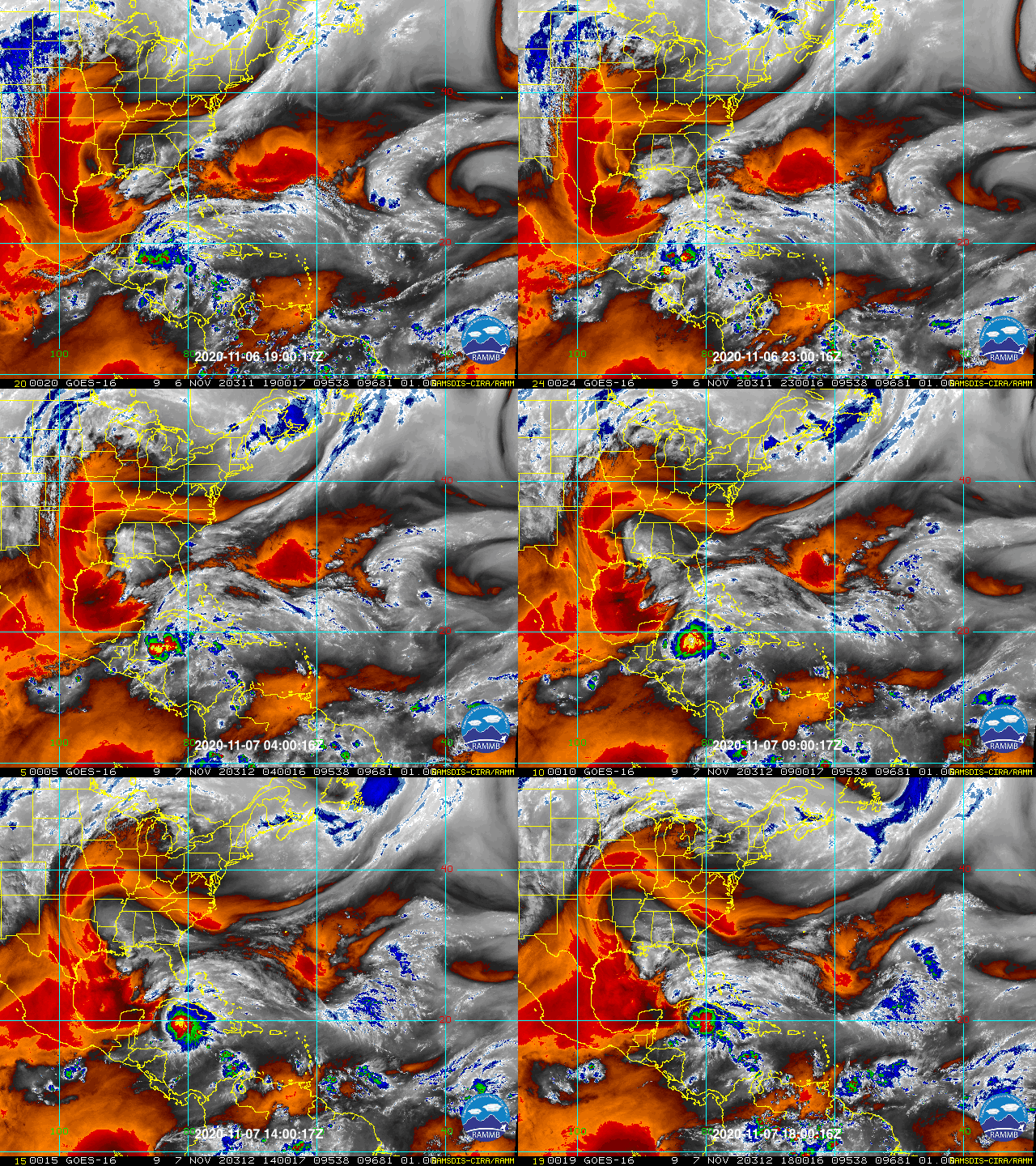
chaser1 wrote:Dry air appears to be eroding the south side of the core like Space Invaders on a game console LOL.


Boy is it ever, take a look at this loop. November strikes! :eek:

Image
0 likes   

User avatar
wxman57
Moderator-Pro Met
Moderator-Pro Met
Posts: 22983
Age: 67
Joined: Sat Jun 21, 2003 8:06 pm
Location: Houston, TX (southwest)

Re: ATL: ETA - Tropical Storm - Discussion

#3196 Postby wxman57 » Sat Nov 07, 2020 2:01 pm

chaser1 wrote:Dry air appears to be eroding the south side of the core like Space Invaders on a game console LOL. It may not be enough to kill it, but it certainly might be enough to question whether any additional near term intensification will occur. I think we'll see pressures and winds level off right around where they are now. If NHC believes that this dry air will continue to entrain into the storms circulation, then it's hard for me to conceive NHC pulling the Hurricane Watch card for the Keys or S. Florida. Now, if they see the dry air abating then that would be another story. My guess is that they'll wait until later this evening to consider whether it'll warrant Hurricane Watches. If the storms structure continues to degrade, i'd have to disagree with Wxman on this one.


I was just about to post that dry air is taking its toll on Eta. My point about the hurricane watch was if you're forecasting a storm to hit with 65 mph winds in 36 hours and there is a 10-15 mph typical margin of error, then why wouldn't a hurricane watch be issued? I see Beven is on the NHC forecast desk. He's a good forecaster. I've known him for many years. Eta may have peaked right about the time recon got there. It's clearly transforming into a larger system now, as predicted. Core may weaken as it does so, but it could regenerate near south Florida.
2 likes   

AutoPenalti
Category 5
Category 5
Posts: 4030
Age: 29
Joined: Mon Aug 17, 2015 4:16 pm
Location: Ft. Lauderdale, Florida

Re: ATL: ETA - Tropical Storm - Discussion

#3197 Postby AutoPenalti » Sat Nov 07, 2020 2:03 pm

Convection drying out quickly, this won’t last.

Mesovort may have collapsed, intensification expected after Cuba.
Last edited by AutoPenalti on Sat Nov 07, 2020 2:04 pm, edited 2 times in total.
0 likes   
The posts in this forum are NOT official forecasts and should not be used as such. They are just the opinion of the poster and may or may not be backed by sound meteorological data. They are NOT endorsed by any professional institution or STORM2K. For official information, please refer to products from the NHC and NWS.


Model Runs Cheat Sheet:
GFS (5:30 AM/PM, 11:30 AM/PM)
HWRF, GFDL, UKMET, NAVGEM (6:30-8:00 AM/PM, 12:30-2:00 AM/PM)
ECMWF (1:45 AM/PM)

TCVN
is a weighted averaged

User avatar
SouthDadeFish
Professional-Met
Professional-Met
Posts: 2835
Joined: Thu Sep 23, 2010 2:54 pm
Location: Miami, FL
Contact:

Re: ATL: ETA - Tropical Storm - Discussion

#3198 Postby SouthDadeFish » Sat Nov 07, 2020 2:04 pm

This dry-air intrusion was anticipated by the models. These same models also show the inner core of Eta moistening by tomorrow morning on approach to FL. This is the same time when shear will temporarily drop to more favorable levels. I could see some last-minute intensification on approach to FL.
5 likes   

Cat5James
Category 1
Category 1
Posts: 417
Joined: Fri Sep 06, 2019 7:54 pm

Re: ATL: ETA - Tropical Storm - Discussion

#3199 Postby Cat5James » Sat Nov 07, 2020 2:04 pm

Go take a look at the hurricane models from 12Z.... this decay of convection due to dry air entrainment was projected... a much healthier looking system is still displayed north of Cuba.
2 likes   

Cat5James
Category 1
Category 1
Posts: 417
Joined: Fri Sep 06, 2019 7:54 pm

Re: ATL: ETA - Tropical Storm - Discussion

#3200 Postby Cat5James » Sat Nov 07, 2020 2:04 pm

SouthDadeFish wrote:This dry-air intrusion was anticipated by the models. These same models also show the inner core of Eta moistening by tomorrow morning on approach to FL. This is the same time when shear will temporarily drop to more favorable levels. I could see some last-minute intensification on approach to FL.

You beat me to it lol...
0 likes   


Return to “2020”

Who is online

Users browsing this forum: No registered users and 5 guests