ATL: ETA - Post-Tropical - Discussion
Moderator: S2k Moderators
-
SFLcane

- S2K Supporter

- Posts: 10281
- Age: 48
- Joined: Sat Jun 05, 2010 1:44 pm
- Location: Lake Worth Florida
Re: ATL: ETA - Tropical Depression - Discussion
Recon going to be interesting if we finally have a well defined llc under that convection if we should start paying attention to the models. I am also pretty sure this is now a TS my guess 45-50 mph.
1 likes

Re: ATL: ETA - Tropical Depression - Discussion
12Z Guidance is out... northward shift... landfall anywhere from middle Keys to PBC
1 likes

Re: ATL: ETA - Tropical Depression - Discussion
Judging by visible satellite loops, I believe we’re looking at a tilted TC, with Eta’s LLC on the edge of its convective mass and the MLC somewhere within the deepest convection. Just my two cents. We will know within the next hour or so once recon arrives.
0 likes
Irene '11 Sandy '12 Hermine '16 5/15/2018 Derecho Fay '20 Isaias '20 Elsa '21 Henri '21 Ida '21
I am only a meteorology enthusiast who knows a decent amount about tropical cyclones. Look to the professional mets, the NHC, or your local weather office for the best information.
I am only a meteorology enthusiast who knows a decent amount about tropical cyclones. Look to the professional mets, the NHC, or your local weather office for the best information.
-
SFLcane
- S2K Supporter
- Posts: 10281
- Age: 48
- Joined: Sat Jun 05, 2010 1:44 pm
- Location: Lake Worth Florida
Re: ATL: ETA - Tropical Depression - Discussion
Cat5James wrote:12Z Guidance is out... northward shift... landfall anywhere from middle Keys to PBC
Indeed.. consensus tcvn model is now north of official forecast I am expecting a shift north in track at 10am likely.
0 likes
-
SFLcane
- S2K Supporter
- Posts: 10281
- Age: 48
- Joined: Sat Jun 05, 2010 1:44 pm
- Location: Lake Worth Florida
Re: ATL: ETA - Tropical Depression - Discussion
aspen wrote:Judging by visible satellite loops, I believe we’re looking at a tilted TC, with Eta’s LLC on the edge of its convective mass and the MLC somewhere within the deepest convection. Just my two cents. We will know within the next hour or so once recon arrives.
It’s likely under convection now.
0 likes
-
Dean4Storms
- S2K Supporter
- Posts: 6358
- Age: 63
- Joined: Sun Aug 31, 2003 1:01 pm
- Location: Miramar Bch. FL
Re: ATL: ETA - Tropical Depression - Discussion
Definitely looks more organized and the LLC established within the convection. I suspect Recon will find a 50mph TS.
0 likes

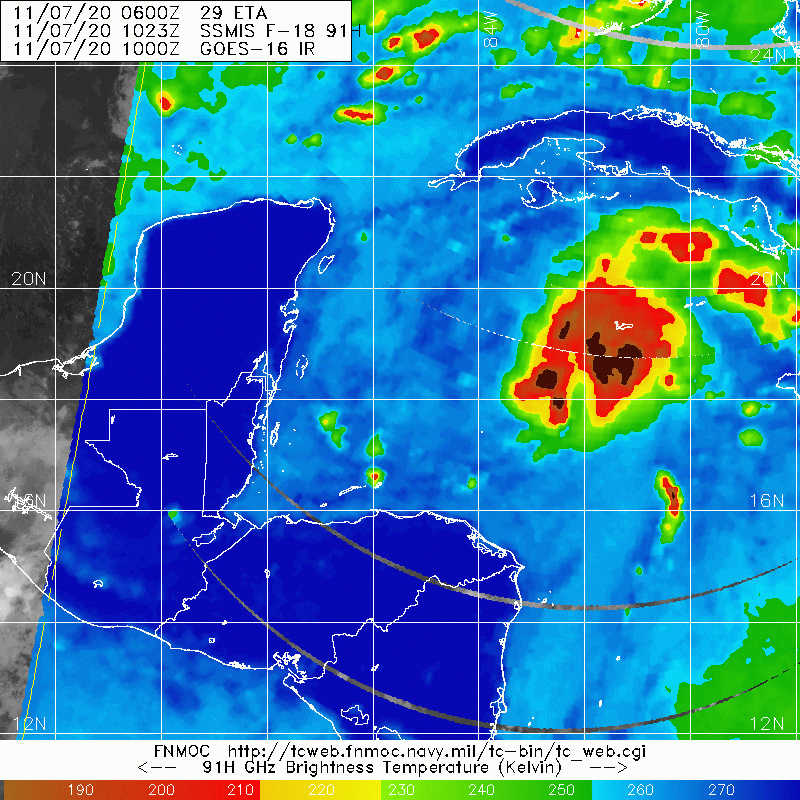
Re: ATL: ETA - Tropical Depression - Discussion
SFLcane wrote:aspen wrote:Judging by visible satellite loops, I believe we’re looking at a tilted TC, with Eta’s LLC on the edge of its convective mass and the MLC somewhere within the deepest convection. Just my two cents. We will know within the next hour or so once recon arrives.
It’s likely under convection now.
https://i.postimg.cc/vZrJngq7/6425-E3-A6-C383-4-DA3-9-CFE-C563-F9-FF7765.jpg
That is definitely the LLC, winds have switched from the East over the Cayman Islands, it is much further South and East than estimated at 12z by the NHC.
2 likes
-
Blown Away

- S2K Supporter
- Posts: 10253
- Joined: Wed May 26, 2004 6:17 am
Re: ATL: ETA - Tropical Depression - Discussion
SFLcane wrote:Cat5James wrote:12Z Guidance is out... northward shift... landfall anywhere from middle Keys to PBC
Indeed.. consensus tcvn model is now north of official forecast I am expecting a shift north in track at 10am likely.
Eta keeps moving S of the track resulting in a flattening of the turns.
0 likes
Hurricane Eye Experience: David 79, Irene 99, Frances 04, Jeanne 04, Wilma 05… Hurricane Brush Experience: Andrew 92, Erin 95, Floyd 99, Matthew 16, Irma 17, Ian 22, Nicole 22…
-
SFLcane
- S2K Supporter
- Posts: 10281
- Age: 48
- Joined: Sat Jun 05, 2010 1:44 pm
- Location: Lake Worth Florida
Re: ATL: ETA - Tropical Depression - Discussion
Blown Away wrote:SFLcane wrote:Cat5James wrote:12Z Guidance is out... northward shift... landfall anywhere from middle Keys to PBC
Indeed.. consensus tcvn model is now north of official forecast I am expecting a shift north in track at 10am likely.
Eta keeps moving S of the track resulting in a flattening of the turns.
Exactly instead of a sharp turn potentially.
0 likes
Re: ATL: ETA - Tropical Depression - Discussion
Recon just found what looks like a circulation WAY outside of the convective mass.
0 likes
Irene '11 Sandy '12 Hermine '16 5/15/2018 Derecho Fay '20 Isaias '20 Elsa '21 Henri '21 Ida '21
I am only a meteorology enthusiast who knows a decent amount about tropical cyclones. Look to the professional mets, the NHC, or your local weather office for the best information.
I am only a meteorology enthusiast who knows a decent amount about tropical cyclones. Look to the professional mets, the NHC, or your local weather office for the best information.
Re: ATL: ETA - Tropical Depression - Discussion
SFLcane wrote:Blown Away wrote:SFLcane wrote:
Indeed.. consensus tcvn model is now north of official forecast I am expecting a shift north in track at 10am likely.
Eta keeps moving S of the track resulting in a flattening of the turns.
Exactly instead of a sharp turn potentially.
Wouldn’t that also give it a couple more hours north of Cuba to potentially strengthen a bit more because of the turn being more gradual?
1 likes
-
wxman57

- Moderator-Pro Met

- Posts: 23172
- Age: 68
- Joined: Sat Jun 21, 2003 8:06 pm
- Location: Houston, TX (southwest)
Re: ATL: ETA - Tropical Depression - Discussion
Eta's center may well track just north of the Cayman Islands. Will be close. One thing has been consistent in the models - the environment will be the most favorable for strengthening as Eta nears south Florida Sunday night/Monday morning. Once it moves west of the Peninsula, dry air and wind shear will gradually lead to its demise.
0 likes
-
Dean4Storms
- S2K Supporter
- Posts: 6358
- Age: 63
- Joined: Sun Aug 31, 2003 1:01 pm
- Location: Miramar Bch. FL
Re: ATL: ETA - Tropical Depression - Discussion
aspen wrote:Recon just found what looks like a circulation WAY outside of the convective mass.
Saw that, most likely a vortex rotating around the center to the SE.
0 likes
-
SFLcane
- S2K Supporter
- Posts: 10281
- Age: 48
- Joined: Sat Jun 05, 2010 1:44 pm
- Location: Lake Worth Florida
Re: ATL: ETA - Tropical Depression - Discussion
wxman57 wrote:Eta's center may well track just north of the Cayman Islands. Will be close. One thing has been consistent in the models - the environment will be the most favorable for strengthening as Eta nears south Florida Sunday night/Monday morning. Once it moves west of the Peninsula, dry air and wind shear will gradually lead to its demise.
Hurricane watch still coming?
0 likes
-
Emmett_Brown

- Category 5

- Posts: 1433
- Joined: Wed Aug 24, 2005 9:10 pm
- Location: Sarasota FL
Re: ATL: ETA - Tropical Depression - Discussion
aspen wrote:Recon just found what looks like a circulation WAY outside of the convective mass.
I think there were 2 centers yesterday, perhaps another center is closer to convection? Pressures on the high side with the center they found.
0 likes
-
Dean4Storms
- S2K Supporter
- Posts: 6358
- Age: 63
- Joined: Sun Aug 31, 2003 1:01 pm
- Location: Miramar Bch. FL
Re: ATL: ETA - Tropical Depression - Discussion
wxman57 wrote:Eta's center may well track just north of the Cayman Islands. Will be close. One thing has been consistent in the models - the environment will be the most favorable for strengthening as Eta nears south Florida Sunday night/Monday morning. Once it moves west of the Peninsula, dry air and wind shear will gradually lead to its demise.
Strangely enough the ECM continues to blow it up into a hurricane out west of the Peninsula in the eastern Gulf. It does get nailed eventually by the dry air and becomes much of nothing headed toward the FL Panhandle.
0 likes
Re: ATL: ETA - Tropical Depression - Discussion
Recon is already showing that the Eta's center is further south and east than estimated earlier this morning.
0 likes
-
wxman57
- Moderator-Pro Met
- Posts: 23172
- Age: 68
- Joined: Sat Jun 21, 2003 8:06 pm
- Location: Houston, TX (southwest)
Re: ATL: ETA - Tropical Depression - Discussion
aspen wrote:Recon just found what looks like a circulation WAY outside of the convective mass.
Not a center. Not part of Eta. Looks like plane is now having communications issues.
3 likes
-
Blown Away
- S2K Supporter
- Posts: 10253
- Joined: Wed May 26, 2004 6:17 am
Re: ATL: ETA - Tropical Depression - Discussion
wxman57 wrote:Eta's center may well track just north of the Cayman Islands. Will be close. One thing has been consistent in the models - the environment will be the most favorable for strengthening as Eta nears south Florida Sunday night/Monday morning. Once it moves west of the Peninsula, dry air and wind shear will gradually lead to its demise.
Cayman’s are outside of the NHC previous advisory cone, so in the short term Eta is going S and E of the NHC track.
0 likes
Hurricane Eye Experience: David 79, Irene 99, Frances 04, Jeanne 04, Wilma 05… Hurricane Brush Experience: Andrew 92, Erin 95, Floyd 99, Matthew 16, Irma 17, Ian 22, Nicole 22…
Who is online
Users browsing this forum: No registered users and 7 guests