ATL: ETA - Post-Tropical - Discussion
Moderator: S2k Moderators
-
Dean4Storms
- S2K Supporter

- Posts: 6358
- Age: 63
- Joined: Sun Aug 31, 2003 1:01 pm
- Location: Miramar Bch. FL
Re: ATL: ETA - Tropical Depression - Discussion
About worn out on the tropics this year but have to admit the evolution of how this plays out is purely weather geek stuff.
12 likes
-
Loveweather12
- Tropical Storm

- Posts: 136
- Joined: Thu Aug 20, 2020 2:37 pm
Re: ATL: ETA - Tropical Depression - Discussion
TheStormExpert wrote:AutoPenalti wrote:Meh, that track may shift back.
Remember the cone just expresses where the center may be. Impacts will be felt regardless.
The trend this season is for the forecast cones to trend west as time progresses it seems, with only a few exceptions like Sally.
Every storm is different. I remember many on here saying the Storm was going W into EPAC and not to worry. Look at where we are.
We just have to watch this
4 likes
-
gatorcane

- S2K Supporter
- Posts: 23708
- Age: 48
- Joined: Sun Mar 13, 2005 3:54 pm
- Location: Boca Raton, FL
Re: ATL: ETA - Tropical Depression - Discussion
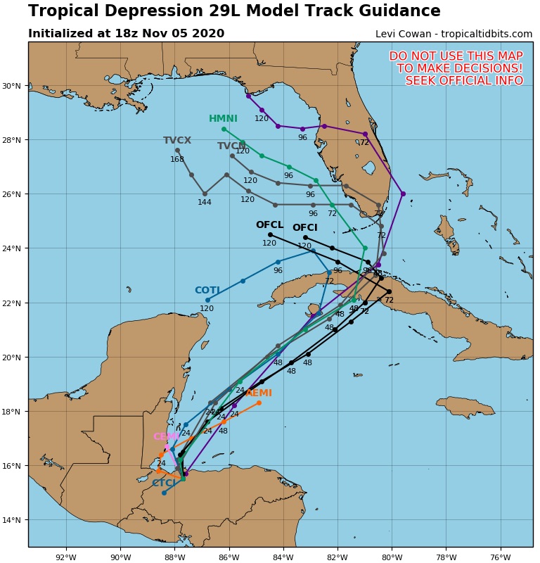
SFLcane wrote:Not to often you see the nhc not side by side with the TCVN consensus model. Not to sure what the overall thinking is.
https://i.postimg.cc/sDHxnSMy/5-CA80-BC0-55-CD-4017-BA21-DADFA37-DC4-BE.jpg
They have other models like the FSSE (Florida State Super Ensembles) which are probably close to the Euro as well which turn this west into the Gulf before reaching Southern Florida.
The story of this season as been strong high pressure which models have typically underestimated.
3 likes
-
TheStormExpert
Re: ATL: ETA - Tropical Depression - Discussion
SFLcane wrote:Not to often you see the nhc not side by side with the TCVN consensus model. Not to sure what the overall thinking is.
https://i.postimg.cc/sDHxnSMy/5-CA80-BC0-55-CD-4017-BA21-DADFA37-DC4-BE.jpg
One thing I will say is the TVCN brings Eta to South Florida in 72hrs., while the NHC has Eta over Cuba in 72hrs.
0 likes
-
AutoPenalti
- Category 5

- Posts: 4091
- Age: 29
- Joined: Mon Aug 17, 2015 4:16 pm
- Location: Ft. Lauderdale, Florida
Re: ATL: ETA - Tropical Depression - Discussion
gatorcane wrote:SFLcane wrote:Not to often you see the nhc not side by side with the TCVN consensus model. Not to sure what the overall thinking is.
https://i.postimg.cc/sDHxnSMy/5-CA80-BC0-55-CD-4017-BA21-DADFA37-DC4-BE.jpg
They have other models like the FSSE (Florida State Super Ensembles) which are probably close to the Euro as well which turn this west into the Gulf before reaching Southern Florida.
The story of this season as been strong high pressure which models have typically underestimated.
I've never heard of that model.
0 likes
The posts in this forum are NOT official forecasts and should not be used as such. They are just the opinion of the poster and may or may not be backed by sound meteorological data. They are NOT endorsed by any professional institution or STORM2K. For official information, please refer to products from the NHC and NWS.
Model Runs Cheat Sheet:
GFS (5:30 AM/PM, 11:30 AM/PM)
HWRF, GFDL, UKMET, NAVGEM (6:30-8:00 AM/PM, 12:30-2:00 AM/PM)
ECMWF (1:45 AM/PM)
TCVN is a weighted averaged
-
johngaltfla

- Category 5
- Posts: 2073
- Joined: Sun Jul 10, 2005 9:17 pm
- Location: Sarasota County, FL
- Contact:
Re: ATL: ETA - Tropical Depression - Discussion
Dean4Storms wrote:About worn out on the tropics this year but have to admit the evolution of how this plays out is purely weather geek stuff.
Post of the season!
4 likes
Re: ATL: ETA - Tropical Depression - Discussion
aspen wrote:Surprisingly high OHC just north of the western tip of Cuba.
https://rammb-data.cira.colostate.edu/tc_realtime/products/storms/2020al29/ohcnfcst/2020al29_ohcnfcst_202011051200.gif
Considering it’s November the entire east coast of FL also good enough to keep a storm at intensity
0 likes
-
Spacecoast

- Category 2

- Posts: 773
- Joined: Thu Aug 31, 2017 2:03 pm
Re: ATL: ETA - Tropical Depression - Discussion
AutoPenalti wrote:gatorcane wrote:SFLcane wrote:Not to often you see the nhc not side by side with the TCVN consensus model. Not to sure what the overall thinking is.
https://i.postimg.cc/sDHxnSMy/5-CA80-BC0-55-CD-4017-BA21-DADFA37-DC4-BE.jpg
They have other models like the FSSE (Florida State Super Ensembles) which are probably close to the Euro as well which turn this west into the Gulf before reaching Southern Florida.
The story of this season as been strong high pressure which models have typically underestimated.
I've never heard of that model.
Florida State University Super-ensemble Corrected Consensus
Public access restricted due to agreement with the data provider.
Cycle Frequency: 6 hr (120 hr)
Parameters forecast: Track and Intensity
Ensemble Consenus Members (according to NHC model page): AVNI / EMXI / HWFI / CTCI / EGRI / NGPI
0 likes

Re: ATL: ETA - Tropical Depression - Discussion
Eta has left severe impacts in Central America.
From Honduras
Eta has left deaths, floods, destroyed roads and victims in Honduras
Death toll rises to 11 in Honduras
From Nicaragua
In Wawa Bar everything has been destroyed
From Guatemala
rains, landslides and deaths in Guatemala
From Panama
Five deaths in Chiriquí and two missing people are reported
Last edited by Macrocane on Thu Nov 05, 2020 5:05 pm, edited 1 time in total.
4 likes
-
TheStormExpert
Re: ATL: ETA - Tropical Depression - Discussion
You guys might want to checkout the 18z "Happy Hour" GFS run! 
0 likes
-
gatorcane
- S2K Supporter
- Posts: 23708
- Age: 48
- Joined: Sun Mar 13, 2005 3:54 pm
- Location: Boca Raton, FL
Re: ATL: ETA - Tropical Depression - Discussion
gatorcane wrote:SFLcane wrote:Not to often you see the nhc not side by side with the TCVN consensus model. Not to sure what the overall thinking is.
https://i.postimg.cc/sDHxnSMy/5-CA80-BC0-55-CD-4017-BA21-DADFA37-DC4-BE.jpg
They have other models like the FSSE (Florida State Super Ensembles) which are probably close to the Euro as well which turn this west into the Gulf before reaching Southern Florida.
The story of this season as been strong high pressure which models have typically underestimated.
Also one other trend of 2020 is that storms end up stronger than originally modeled.
2 likes
-
Do_For_Love
- Category 1

- Posts: 271
- Age: 35
- Joined: Sat May 09, 2015 7:47 am
- Location: Delaware
Re: ATL: ETA - Tropical Depression - Discussion
Macrocane wrote:Eta has left severe impacts in Central America.
That's terrible. I had a feeling it was going to be bad considering the projected rainfall amounts.
0 likes
Irene '11, Sandy '12, Fay '20, Isaias '20, Ida '21
-
Iceresistance

- Category 5
- Posts: 9580
- Age: 22
- Joined: Sat Oct 10, 2020 9:45 am
- Location: Tecumseh, OK/Norman, OK
Re: ATL: ETA - Tropical Depression - Discussion
TheStormExpert wrote:You guys might want to checkout the 18z "Happy Hour" GFS run!
Eta slamming into Florida & then Future Theta shows up in the Mid-Atlantic going towards the Eastern Atlantic
0 likes
Bill 2015 & Beta 2020
Winter 2020-2021
All observations are in Tecumseh, OK unless otherwise noted.
Winter posts are focused mainly for Oklahoma & Texas.
Take any of my forecasts with a grain of salt, refer to the NWS, SPC, and NHC for official information
Never say Never with weather! Because ANYTHING is possible!
Winter 2020-2021
All observations are in Tecumseh, OK unless otherwise noted.
Winter posts are focused mainly for Oklahoma & Texas.
Take any of my forecasts with a grain of salt, refer to the NWS, SPC, and NHC for official information
Never say Never with weather! Because ANYTHING is possible!
-
Iceresistance
- Category 5
- Posts: 9580
- Age: 22
- Joined: Sat Oct 10, 2020 9:45 am
- Location: Tecumseh, OK/Norman, OK
Re: ATL: ETA - Tropical Depression - Discussion
Eta is getting closer to TS strength. 35 mph & 1005 MB & Tropical storm watches has been issued for the Cayman Islands
But, remember that this system is going to have higher than normal difficulties tracking the storm once it's back out in the West Carribbean, so good luck on where to track this.
And remember: no constant spamming or this will happen: , no -removed- & no Eta jokes on Central America since there is severe devastation there & I feel really bad for them
(I will not be readly on for a while until Eta is stronger & closer to landfall, good luck & keep tracking!)
But, remember that this system is going to have higher than normal difficulties tracking the storm once it's back out in the West Carribbean, so good luck on where to track this.
And remember: no constant spamming or this will happen:
, no -removed- & no Eta jokes on Central America since there is severe devastation there & I feel really bad for them (I will not be readly on for a while until Eta is stronger & closer to landfall, good luck & keep tracking!)
0 likes
Bill 2015 & Beta 2020
Winter 2020-2021
All observations are in Tecumseh, OK unless otherwise noted.
Winter posts are focused mainly for Oklahoma & Texas.
Take any of my forecasts with a grain of salt, refer to the NWS, SPC, and NHC for official information
Never say Never with weather! Because ANYTHING is possible!
Winter 2020-2021
All observations are in Tecumseh, OK unless otherwise noted.
Winter posts are focused mainly for Oklahoma & Texas.
Take any of my forecasts with a grain of salt, refer to the NWS, SPC, and NHC for official information
Never say Never with weather! Because ANYTHING is possible!
-
ElectricStorm

- Category 5
- Posts: 5145
- Age: 25
- Joined: Tue Aug 13, 2019 11:23 pm
- Location: Norman, OK
Re: ATL: ETA - Tropical Depression - Discussion
gatorcane wrote:gatorcane wrote:SFLcane wrote:Not to often you see the nhc not side by side with the TCVN consensus model. Not to sure what the overall thinking is.
https://i.postimg.cc/sDHxnSMy/5-CA80-BC0-55-CD-4017-BA21-DADFA37-DC4-BE.jpg
They have other models like the FSSE (Florida State Super Ensembles) which are probably close to the Euro as well which turn this west into the Gulf before reaching Southern Florida.
The story of this season as been strong high pressure which models have typically underestimated.
Also one other trend of 2020 is that storms end up stronger than originally modeled.
And also pretty much every storm has had some sort of a complicated setup
0 likes
B.S Meteorology, University of Oklahoma '25
Please refer to the NHC, NWS, or SPC for official information.
Please refer to the NHC, NWS, or SPC for official information.
-
Miami Storm Tracker

- Category 4

- Posts: 916
- Age: 68
- Joined: Sun Jun 13, 2010 10:12 pm
- Location: Key Largo, Fla.
- Contact:
Re: ATL: ETA - Tropical Depression - Discussion
Evening everyone
In the models discussion page I have seen a few recent model runs showing a stronger and more east progression with Eta, so why does the track seem to be staying with the sharp left turn, not buying that, not so sharp anyway.
In the models discussion page I have seen a few recent model runs showing a stronger and more east progression with Eta, so why does the track seem to be staying with the sharp left turn, not buying that, not so sharp anyway.
0 likes
-
jlauderdal
- S2K Supporter
- Posts: 7240
- Joined: Wed May 19, 2004 5:46 am
- Location: NE Fort Lauderdale
- Contact:
Re: RE: Re: ATL: ETA - Tropical Depression - Discussion
Me either, nhc is crushes track forecastingMiami Storm Tracker wrote:Evening everyone
In the models discussion page I have seen a few recent model runs showing a stronger and more east progression with Eta, so why does the track seem to be staying with the sharp left turn, not buying that, not so sharp anyway.
0 likes
-
Blown Away

- S2K Supporter
- Posts: 10253
- Joined: Wed May 26, 2004 6:17 am
Re: RE: Re: ATL: ETA - Tropical Depression - Discussion
jlauderdal wrote:Me either, nhc is crushes track forecastingMiami Storm Tracker wrote:Evening everyone
In the models discussion page I have seen a few recent model runs showing a stronger and more east progression with Eta, so why does the track seem to be staying with the sharp left turn, not buying that, not so sharp anyway.
The current NHC advisory does not have the 18z model runs... The next advisory will have a dramatic track change probably into SFL as Cat 1 if they give weight to these model runs...
Or they will continue hanging their hat on the Euro, not a bad bet in a pinch...
3 likes
Hurricane Eye Experience: David 79, Irene 99, Frances 04, Jeanne 04, Wilma 05… Hurricane Brush Experience: Andrew 92, Erin 95, Floyd 99, Matthew 16, Irma 17, Ian 22, Nicole 22…
-
Miami Storm Tracker
- Category 4
- Posts: 916
- Age: 68
- Joined: Sun Jun 13, 2010 10:12 pm
- Location: Key Largo, Fla.
- Contact:
Re: ATL: ETA - Tropical Depression - Discussion
Blownaway
I need to make decisions Lol both for Key Largo and Miami, so cant wait to much longer to decide.
I need to make decisions Lol both for Key Largo and Miami, so cant wait to much longer to decide.
0 likes
-
Blown Away
- S2K Supporter
- Posts: 10253
- Joined: Wed May 26, 2004 6:17 am
Re: ATL: ETA - Tropical Depression - Discussion
Miami Storm Tracker wrote:Blownaway
I need to make decisions Lol both for Key Largo and Miami, so cant wait to much longer to decide.
Gotta wait for next advisory to see if they are giving heavy weight to these models... Usually if it was 5+ days out they would make subtle track change, but Keys could be @45 hours from TS force winds if the 18z is right... I expect dramatic change at next advisory...
Key Largo floods crazy... Ugh
2 likes
Hurricane Eye Experience: David 79, Irene 99, Frances 04, Jeanne 04, Wilma 05… Hurricane Brush Experience: Andrew 92, Erin 95, Floyd 99, Matthew 16, Irma 17, Ian 22, Nicole 22…
Who is online
Users browsing this forum: No registered users and 10 guests