jconsor wrote:https://twitter.com/yconsor/status/1324003331686150144
So are you saying there is the possibility of an intensifying storm?
Moderator: S2k Moderators


jconsor wrote:https://twitter.com/yconsor/status/1324003331686150144
N2FSU wrote:https://uploads.tapatalk-cdn.com/20201104/4012179bf1192a4377f7ca5c65579621.jpg
Sent from my iPhone using Tapatalk


crownweather wrote:Rather than typing my thoughts on Eta based on what I've noticed on satellite imagery, I'll share my tweet.
https://twitter.com/crownweather/status/1324007970523500545
AutoPenalti wrote:crownweather wrote:Rather than typing my thoughts on Eta based on what I've noticed on satellite imagery, I'll share my tweet.
https://twitter.com/crownweather/status/1324007970523500545
Well, we'll find out shortly, GFS is already SW of the 06z and stronger.


LarryWx wrote:So, no new reports today from Honduras?
aspen wrote:LarryWx wrote:So, no new reports today from Honduras?
With the way things are going in the US today, sadly, there’s no way the media will devote any time to Eta’s impacts.
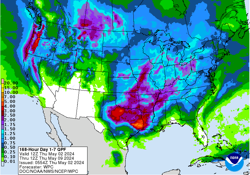
wxman57 wrote:It's really uncertain what kind of a mess will emerge into the western Caribbean on Friday. I wouldn't put too much stock in any model's forecast of precisely where the new low center will form just yet. The track across Cuba and possibly over the FL Peninsula will be highly dependent on where the new center develops and how quickly it can organize south of Cuba. We won't have a better idea of possible FL impacts until Saturday.
fci wrote:wxman57 wrote:It's really uncertain what kind of a mess will emerge into the western Caribbean on Friday. I wouldn't put too much stock in any model's forecast of precisely where the new low center will form just yet. The track across Cuba and possibly over the FL Peninsula will be highly dependent on where the new center develops and how quickly it can organize south of Cuba. We won't have a better idea of possible FL impacts until Saturday.
You leaning towards the trend towards this being a GOM issue more than the slingshot to the Atlantic and then across the FL Peninsula (like King-1950)?


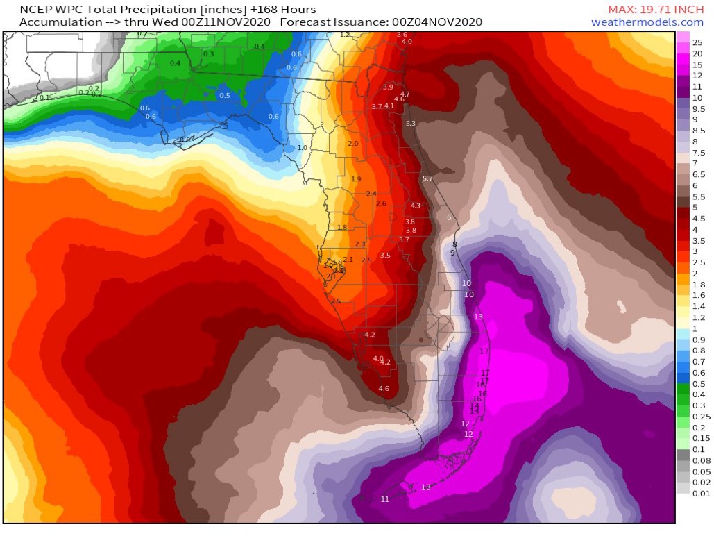
SFLcane wrote:Wow! Going to need a bigger boat
This is Irene 99 type potential
https://i.postimg.cc/3JXDjSVm/637-D313-E-80-D1-4706-933-E-E27-B1448-DCD5.jpg
VortexFl wrote:SFLcane wrote:Wow! Going to need a bigger boat
This is Irene 99 type potential
https://i.postimg.cc/3JXDjSVm/637-D313-E-80-D1-4706-933-E-E27-B1448-DCD5.jpg
Unreal rainfall potential along the SE fl coast this weekend. & in November!!
Users browsing this forum: No registered users and 13 guests


