. I dunno- I don’t think Eta will be anywhere near that intense- now track wise it could have some similarities.Blown Away wrote:VortexFl wrote:Hurricane King may be a decent analog..
https://images.app.goo.gl/zicVvB8T3eNdWJJWA
https://images.app.goo.gl/rgvys7yo2Y7hbCwf7
Truly the only analog that looks like the current modeling.
ATL: ETA - Models
Moderator: S2k Moderators
-
otowntiger
- Category 5

- Posts: 1932
- Joined: Tue Aug 31, 2004 7:06 pm
Re: ATL: ETA - Models
0 likes

Re: ATL: ETA - Models
How well has ICON performed with ETA thus far? & which model has done best??
0 likes

-
Blown Away

- S2K Supporter

- Posts: 10253
- Joined: Wed May 26, 2004 6:17 am
Re: ATL: ETA - Models
18z a little faster than 12z... Seems the trend is moving Eta faster to the NE after exiting Honduras then turning NNW near/over Florida... Except for the mighty Euro which is slower and usually faster than most models...
0 likes
Hurricane Eye Experience: David 79, Irene 99, Frances 04, Jeanne 04, Wilma 05… Hurricane Brush Experience: Andrew 92, Erin 95, Floyd 99, Matthew 16, Irma 17, Ian 22, Nicole 22…
-
otowntiger
- Category 5
- Posts: 1932
- Joined: Tue Aug 31, 2004 7:06 pm
Re: ATL: ETA - Models
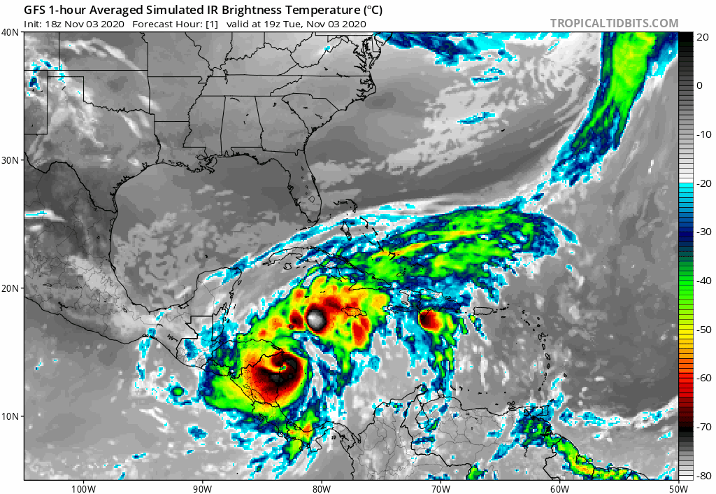
yeah- I noticed the same thing- it went down from a 3 to a 2 on approach to Cuba. I’d be surprised if it got anywhere near that strong after nearly dissipating over Honduras.TheStormExpert wrote:Blown Away wrote:https://i.imgur.com/cG4w6fU.jpg
Coamps showing an intensifying hurricane moving towards Cuba/FL.
Looks to be weakening from Cat.3 to Cat.2?
0 likes
Re: ATL: ETA - Models
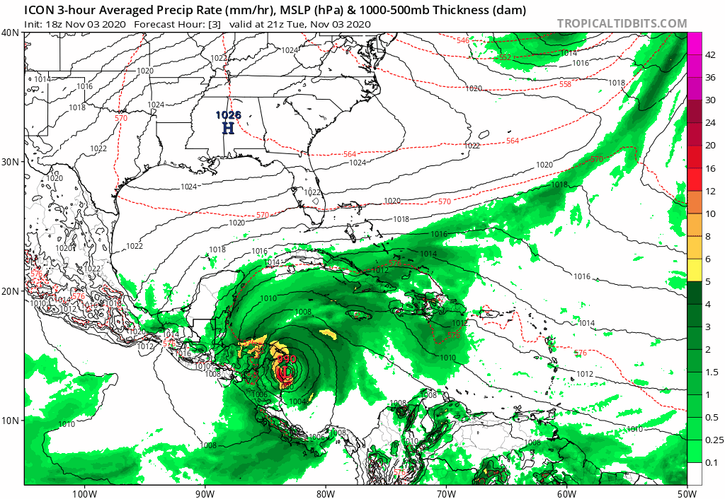
Snipet from NWS Miami afternoon disco:
"East Coast 7-10" of rain localized amounts up to 15"
.Hydrology...
The long range models are also showing that the PWAT values will
be in the 2.1 to 2.4 inches range which is at the maximum value
for the PWAT values for this time of Year. This means that any
showers and thunderstorms that do develop will be capable of
producing heavy rainfall this weekend. Weather Prediction Center
(WPC) is also forecasting at this time around 3 to 5 inches for
the west coast metro areas to 7 to 10 inches for the east coast
metro areas with isolated amounts up to 15 inches mainly between
Friday early next week. Will continue to monitor the the forecast
model runs on the potential of heavy rainfall for South Florida
this weekend, and if trends continue then a Flood Watch may be
needed late this week for this weekend.
0 likes
-
Spacecoast

- Category 2

- Posts: 773
- Joined: Thu Aug 31, 2017 2:03 pm
Re: ATL: ETA - Models
18z Spaghetti includes GEFS, Euro Ens, early guidance, and deterministic plots.
white is consensus, black dot is 120 hr ,which is very close to NHC guidance @ 1pm Sunday (just E of Marathon).

white is consensus, black dot is 120 hr ,which is very close to NHC guidance @ 1pm Sunday (just E of Marathon).
4 likes
-
Blown Away
- S2K Supporter
- Posts: 10253
- Joined: Wed May 26, 2004 6:17 am
Re: ATL: ETA - Models
otowntiger wrote:yeah- I noticed the same thing- it went down from a 3 to a 2 on approach to Cuba. I’d be surprised if it got anywhere near that strong after nearly dissipating over Honduras.TheStormExpert wrote:Blown Away wrote:https://i.imgur.com/cG4w6fU.jpg
Coamps showing an intensifying hurricane moving towards Cuba/FL.
Looks to be weakening from Cat.3 to Cat.2?
It goes from a 3 to a 2, but notice the green shading on the second Cat 2 dot is lighter green which I think indicates a strengthening Cat 2...
1 likes
Hurricane Eye Experience: David 79, Irene 99, Frances 04, Jeanne 04, Wilma 05… Hurricane Brush Experience: Andrew 92, Erin 95, Floyd 99, Matthew 16, Irma 17, Ian 22, Nicole 22…
-
SouthFLTropics

- Category 5
- Posts: 4258
- Age: 50
- Joined: Thu Aug 14, 2003 8:04 am
- Location: Port St. Lucie, Florida
Re: ATL: ETA - Models
18z GFS slower than 12z, more in line with what the Euro was showing through 114 hours so far.
0 likes
Fourth Generation Florida Native
Personal Storm History: David 79, Andrew 92, Erin 95, Floyd 99, Irene 99, Frances 04, Jeanne 04, Wilma 05, Matthew 16, Irma 17, Ian 22, Nicole 22, Milton 24
Personal Storm History: David 79, Andrew 92, Erin 95, Floyd 99, Irene 99, Frances 04, Jeanne 04, Wilma 05, Matthew 16, Irma 17, Ian 22, Nicole 22, Milton 24
-
SouthFLTropics
- Category 5
- Posts: 4258
- Age: 50
- Joined: Thu Aug 14, 2003 8:04 am
- Location: Port St. Lucie, Florida
Re: ATL: ETA - Models
Ironically, these 18z GFS is starting to look like the GFS-Para run the other day that had "twins".
0 likes
Fourth Generation Florida Native
Personal Storm History: David 79, Andrew 92, Erin 95, Floyd 99, Irene 99, Frances 04, Jeanne 04, Wilma 05, Matthew 16, Irma 17, Ian 22, Nicole 22, Milton 24
Personal Storm History: David 79, Andrew 92, Erin 95, Floyd 99, Irene 99, Frances 04, Jeanne 04, Wilma 05, Matthew 16, Irma 17, Ian 22, Nicole 22, Milton 24

Re: ATL: ETA - Models
otowntiger wrote:yeah- I noticed the same thing- it went down from a 3 to a 2 on approach to Cuba. I’d be surprised if it got anywhere near that strong after nearly dissipating over Honduras.TheStormExpert wrote:Blown Away wrote:https://i.imgur.com/cG4w6fU.jpg
Coamps showing an intensifying hurricane moving towards Cuba/FL.
Looks to be weakening from Cat.3 to Cat.2?
Who knows. Two days ago the GFS had Eta landfalling in Nicaragua as a Cat 1. The key is - do they have a storm in the region, and is there any obvious reason (sheer, cooler water, dry air, etc) that it shouldnt just keep strengthening once is gets its act togehter.
3 likes
Re: ATL: ETA - Models
Blown Away wrote:
18z a little faster than 12z... Seems the trend is moving Eta faster to the NE after exiting Honduras then turning NNW near/over Florida... Except for the mighty Euro which is slower and usually faster than most models...
Also, except for the sometimes considered semi-mighty UKMET, which still goes into the E Pac!
0 likes
Personal Forecast Disclaimer:
The posts in this forum are NOT official forecasts and should not be used as such. They are just the opinion of the poster and may or may not be backed by sound meteorological data. They are NOT endorsed by any professional institution or storm2k.org. For official information, please refer to the NHC and NWS products.
The posts in this forum are NOT official forecasts and should not be used as such. They are just the opinion of the poster and may or may not be backed by sound meteorological data. They are NOT endorsed by any professional institution or storm2k.org. For official information, please refer to the NHC and NWS products.
-
Blown Away
- S2K Supporter
- Posts: 10253
- Joined: Wed May 26, 2004 6:17 am
Re: ATL: ETA - Models
As these models close in on 5 day range it looks like a big sheared frontal mess that will dump boat loads of rain on Florida ATM.
2 likes
Hurricane Eye Experience: David 79, Irene 99, Frances 04, Jeanne 04, Wilma 05… Hurricane Brush Experience: Andrew 92, Erin 95, Floyd 99, Matthew 16, Irma 17, Ian 22, Nicole 22…

Re: ATL: ETA - Models
Blown Away wrote:As these models close in on 5 day range it looks like a big sheared frontal mess that will dump boat loads of rain on Florida ATM.
a sheared mess is awesome! flooding not of course but less wind damage and not hardly any surge we’ll take it over a hurricane any day. i wish it would go out to sea though. i’m so ready for winter and i hate the cold but this season is long and arduous.
0 likes
Robbielyn McCrary
I know just about enough to sound like I know what I'm talking about sometimes. But for your safety please follow the nhc for truly professional forecasting.
I know just about enough to sound like I know what I'm talking about sometimes. But for your safety please follow the nhc for truly professional forecasting.
-
Spacecoast
- Category 2
- Posts: 773
- Joined: Thu Aug 31, 2017 2:03 pm
Re: ATL: ETA - Models
0z Intensity guidance...
CEM2 shoots the Yuc channel, and avoids land interaction going to CAT3
SHIP, & CTCI (NRL-COAMPS 5km model), are slow movers, bringing to CAT1 /CAT2 level.
HWFI weakens as it travels up FL spine.
COTI & UKX2 are EPAC regeneration.

Chart is better understood when considering tracks of these models:

CEM2 shoots the Yuc channel, and avoids land interaction going to CAT3
SHIP, & CTCI (NRL-COAMPS 5km model), are slow movers, bringing to CAT1 /CAT2 level.
HWFI weakens as it travels up FL spine.
COTI & UKX2 are EPAC regeneration.
Chart is better understood when considering tracks of these models:
1 likes
-
TheStormExpert
Re: ATL: ETA - Models
Blown Away wrote:As these models close in on 5 day range it looks like a big sheared frontal mess that will dump boat loads of rain on Florida ATM.
Probably another Irene 1999. Nothing to loose sleep over. Just more rain for the water logged South Florida.
1 likes
-
Blown Away
- S2K Supporter
- Posts: 10253
- Joined: Wed May 26, 2004 6:17 am
Re: ATL: ETA - Models
TheStormExpert wrote:Blown Away wrote:As these models close in on 5 day range it looks like a big sheared frontal mess that will dump boat loads of rain on Florida ATM.
Probably another Irene 1999. Nothing to loose sleep over. Just more rain for the water logged South Florida.
Yeah, I think once Eta gets up near Florida it will likely be heavily R sided with the convection, so whoever is on the R side of Eta could see huge rainfall.
0 likes
Hurricane Eye Experience: David 79, Irene 99, Frances 04, Jeanne 04, Wilma 05… Hurricane Brush Experience: Andrew 92, Erin 95, Floyd 99, Matthew 16, Irma 17, Ian 22, Nicole 22…
-
TheStormExpert
Re: ATL: ETA - Models
Blown Away wrote:TheStormExpert wrote:Blown Away wrote:As these models close in on 5 day range it looks like a big sheared frontal mess that will dump boat loads of rain on Florida ATM.
Probably another Irene 1999. Nothing to loose sleep over. Just more rain for the water logged South Florida.
Yeah, I think once Eta gets up near Florida it will likely be heavily R sided with the convection, so whoever is on the R side of Eta could see huge rainfall.
Levi Cowan said in his latest video tonight that the upper level pattern doesn’t support a strong hurricane like what the Euro was showing yesterday. In fact it will likely take on a more comma/Subtropical look.
https://youtu.be/20PM4mY4fso
0 likes
Re: ATL: ETA - Models
TheStormExpert wrote:Who wants to place a bet! Left, right, or over the peninsula?
Maybe this is how Georgia gets a super rare coastal landfall
0 likes
Who is online
Users browsing this forum: No registered users and 18 guests