ATL: ETA - Models
Moderator: S2k Moderators
-
Weatherboy1

- Category 5

- Posts: 1190
- Age: 50
- Joined: Mon Jul 05, 2004 1:50 pm
- Location: Jupiter/Sarasota, FL
Re: ATL: ETA - Models
Decent consensus building that "something" is coming for the FL peninsula in 5-6 days. Will be interesting to see if the Euro concurs later today. So much depends on what's left of Eta after it emerges (assuming it does) from CA. Doubt it will regain significant hurricane status unless it spends a solid amount of time over the NW Caribbean. But high-end TS or minimal hurricane certainly seems possible.
3 likes
-
SFLcane

- S2K Supporter

- Posts: 10281
- Age: 48
- Joined: Sat Jun 05, 2010 1:44 pm
- Location: Lake Worth Florida
Re: ATL: ETA - Models
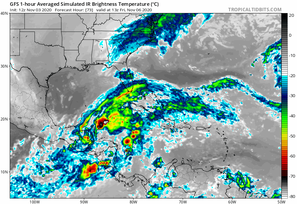
boca wrote:gatorcane wrote:Looks almost subtropical on the GFS IR simulation and sheared. Most of the convection in the Bahamas with barely anything over Florida.
https://i.postimg.cc/nz1j0SmJ/gfs-ir-watl-fh73-115.gif
How do you get the satellite presentation on the GFS model?
Go into upper dynamics tab and select " Simulated IR Satellite “
1 likes
-
TheStormExpert
Re: ATL: ETA - Models
Weatherboy1 wrote:Decent consensus building that "something" is coming for the FL peninsula in 5-6 days. Will be interesting to see if the Euro concurs later today. So much depends on what's left of Eta after it emerges (assuming it does) from CA. Doubt it will regain significant hurricane status unless it spends a solid amount of time over the NW Caribbean. But high-end TS or minimal hurricane certainly seems possible.
Might be more Subtropical in nature according to the latest GFS and CMC. Yesterday’s Euro runs were definitely outliers.
1 likes
-
toad strangler

- S2K Supporter
- Posts: 4546
- Joined: Sun Jul 28, 2013 3:09 pm
- Location: Earth
- Contact:
Re: ATL: ETA - Models
I never like the prospects of a post landfall torn up cyclone regaining meaty stature. More inclined to buy stock in the sheared Tropical Stormish system the GFS and CMC are showing.
0 likes
My Weather Station
https://www.wunderground.com/dashboard/pws/KFLPORTS603
https://www.wunderground.com/dashboard/pws/KFLPORTS603
-
TheProfessor

- Professional-Met

- Posts: 3506
- Age: 29
- Joined: Tue Dec 03, 2013 10:56 am
- Location: Wichita, Kansas
Re: ATL: ETA - Models
One thing to watch that could have major implications on the future track of Eta and it's remnants as well as potential strength. That thing is the westward progression of Eta. If Eta continues to crawl and doesn't make it very far west before it gets pulled to the north, it could miss the mountains to the east. This would allow for Eta to move offshore with a much stronger core and allow it to maintain tropical characteristics in the NW Caribbean. If that's the case Eta would be much more primed for steady intensification if not rapid intensification as it moves to the ENE or NE. A strong Eta would then be able to better battle shear before it potentially gets trapped under a ridge, which could once again provide a better environment. The short term changes of Eta will have a significant effect on mid and long range models.
8 likes
An alumnus of The Ohio State University.
Your local National Weather Service office is your best source for weather information.
Your local National Weather Service office is your best source for weather information.

Re: ATL: ETA - Models
sma10 wrote:SoupBone wrote:tolakram wrote:
Doesn't take much effort to look it up. Long time ago.
https://en.wikipedia.org/wiki/List_of_T ... _(pre-1900)
Haha so 1527 and 1590. Wow.
I guess you'd say they're overdue
I'm just amazed to see that. So in recorded weather history, Texas has only been hit twice in the month of November, 1527 and 1590.
Sorry for the hijack in the models thread, but wow, that is just insane.
0 likes
Personal Forecast Disclaimer:
The posts in this forum are NOT official forecast and should not be used as such. They are just the opinion of the poster and may or may not be backed by sound meteorological data. They are NOT endorsed by any professional institution or storm2k.org. For official information, please refer to the NHC and NWS products.
The posts in this forum are NOT official forecast and should not be used as such. They are just the opinion of the poster and may or may not be backed by sound meteorological data. They are NOT endorsed by any professional institution or storm2k.org. For official information, please refer to the NHC and NWS products.
-
AutoPenalti
- Category 5
- Posts: 4091
- Age: 29
- Joined: Mon Aug 17, 2015 4:16 pm
- Location: Ft. Lauderdale, Florida
Re: ATL: ETA - Models
TheProfessor wrote:One thing to watch that could have major implications on the future track of Eta and it's remnants as well as potential strength. That thing is the westward progression of Eta. If Eta continues to crawl and doesn't make it very far west before it gets pulled to the north, it could miss the mountains to the east. This would allow for Eta to move offshore with a much stronger core and allow it to maintain tropical characteristics in the NW Caribbean. If that's the case Eta would be much more primed for steady intensification if not rapid intensification as it moves to the ENE or NE. A strong Eta would then be able to better battle shear before it potentially gets trapped under a ridge, which could once again provide a better environment. The short term changes of Eta will have a significant effect on mid and long range models.
This was my initial thought before the whole recon thing happened in yesterday afternoon. It doesn't seem to have made landfall yet. Wasn't this forecast to make landfall like now?
0 likes
The posts in this forum are NOT official forecasts and should not be used as such. They are just the opinion of the poster and may or may not be backed by sound meteorological data. They are NOT endorsed by any professional institution or STORM2K. For official information, please refer to products from the NHC and NWS.
Model Runs Cheat Sheet:
GFS (5:30 AM/PM, 11:30 AM/PM)
HWRF, GFDL, UKMET, NAVGEM (6:30-8:00 AM/PM, 12:30-2:00 AM/PM)
ECMWF (1:45 AM/PM)
TCVN is a weighted averaged
-
Spacecoast

- Category 2

- Posts: 773
- Joined: Thu Aug 31, 2017 2:03 pm
Re: ATL: ETA - Models
10:00 NHC disco: "It is still not certain if the surface circulation will survive its trek over Central America during the next several
days, but the official forecast continues to show the remnants of Eta emerging over the northwestern Caribbean Sea late this week."
6z GEFS Ensembles still have only ~50% surviving to re-emerge into WCar...
17 members out 33 dissipate?

16 members out of 33 re-emerge. It must be said that these include the operational, the control member, & ensemble mean member.

I'm still puzzled by this. It seems like re-emergence is a foregone conclusion, and I would agree with that.
But it seems the ensembles are still not convinced.
days, but the official forecast continues to show the remnants of Eta emerging over the northwestern Caribbean Sea late this week."
6z GEFS Ensembles still have only ~50% surviving to re-emerge into WCar...
17 members out 33 dissipate?
16 members out of 33 re-emerge. It must be said that these include the operational, the control member, & ensemble mean member.
I'm still puzzled by this. It seems like re-emergence is a foregone conclusion, and I would agree with that.
But it seems the ensembles are still not convinced.
0 likes
-
AutoPenalti
- Category 5
- Posts: 4091
- Age: 29
- Joined: Mon Aug 17, 2015 4:16 pm
- Location: Ft. Lauderdale, Florida
Re: ATL: ETA - Models
Spacecoast wrote:10:00 NHC disco: "It is still not certain if the surface circulation will survive its trek over Central America during the next several
days, but the official forecast continues to show the remnants of Eta emerging over the northwestern Caribbean Sea late this week."
6z GEFS Ensembles still have only ~50% surviving to re-emerge into WCar...
17 members out 33 dissipate?
https://i.ibb.co/cLFm7dC/Capture113a.jpg
16 members out of 33 re-emerge. It must be said that these include the operational, the control member, & ensemble mean member.
https://i.ibb.co/F8nv6rS/Capture113b.jpg
I'm still puzzled by this. It seems like re-emergence is a foregone conclusion, and I would agree with that.
But it seems the ensembles are still not convinced.
Keep in mind that the LLC may dissapate, the MLC may not.
2 likes
The posts in this forum are NOT official forecasts and should not be used as such. They are just the opinion of the poster and may or may not be backed by sound meteorological data. They are NOT endorsed by any professional institution or STORM2K. For official information, please refer to products from the NHC and NWS.
Model Runs Cheat Sheet:
GFS (5:30 AM/PM, 11:30 AM/PM)
HWRF, GFDL, UKMET, NAVGEM (6:30-8:00 AM/PM, 12:30-2:00 AM/PM)
ECMWF (1:45 AM/PM)
TCVN is a weighted averaged
-
Spacecoast
- Category 2
- Posts: 773
- Joined: Thu Aug 31, 2017 2:03 pm
Re: ATL: ETA - Models
AutoPenalti wrote:Spacecoast wrote:10:00 NHC disco: "It is still not certain if the surface circulation will survive its trek over Central America during the next several
days, but the official forecast continues to show the remnants of Eta emerging over the northwestern Caribbean Sea late this week."
6z GEFS Ensembles still have only ~50% surviving to re-emerge into WCar...
17 members out 33 dissipate?
https://i.ibb.co/cLFm7dC/Capture113a.jpg
16 members out of 33 re-emerge. It must be said that these include the operational, the control member, & ensemble mean member.
https://i.ibb.co/F8nv6rS/Capture113b.jpg
I'm still puzzled by this. It seems like re-emergence is a foregone conclusion, and I would agree with that.
But it seems the ensembles are still not convinced.
Keep in mind that the LLC may dissapate, the MLC may not.
Thanks. That makes sense.
0 likes

Re: ATL: ETA - Models
TheStormExpert wrote:Might be more Subtropical in nature according to the latest GFS and CMC. Yesterday’s Euro runs were definitely outliers.
That is what I've been seeing too, or at least a very lopsided system.
So much depends on Etacs track across Central America. If it does not go inland as far as the NHC projects, the circulation may avoid the mountains and stay intact, setting up significant strengthening when back over water. A disrupted circulation, as currently forecast will take much more time to strengthen, even in highly favorable conditions.
I am very interested to see how the models respond to it's position and direction(or lack there of) now, almost all of them had Eta onshore already if i recall correctly.
0 likes
-
SFLcane
- S2K Supporter
- Posts: 10281
- Age: 48
- Joined: Sat Jun 05, 2010 1:44 pm
- Location: Lake Worth Florida
Re: ATL: ETA - Models
06z COAMPS model forecasting pretty rapid intensification in the nw Caribbean Sea.

3 likes
-
Blown Away

- S2K Supporter
- Posts: 10253
- Joined: Wed May 26, 2004 6:17 am
Re: ATL: ETA - Models
12z HWRF sharper E turn and stronger into the NW Caribbean.
0 likes
Hurricane Eye Experience: David 79, Irene 99, Frances 04, Jeanne 04, Wilma 05… Hurricane Brush Experience: Andrew 92, Erin 95, Floyd 99, Matthew 16, Irma 17, Ian 22, Nicole 22…
-
AutoPenalti
- Category 5
- Posts: 4091
- Age: 29
- Joined: Mon Aug 17, 2015 4:16 pm
- Location: Ft. Lauderdale, Florida
Re: ATL: ETA - Models
HWRF has a 986mb TC into SE Florida by Sunday. Huge deviation from last run. Euro is still running.
Last edited by AutoPenalti on Tue Nov 03, 2020 1:21 pm, edited 2 times in total.
0 likes
The posts in this forum are NOT official forecasts and should not be used as such. They are just the opinion of the poster and may or may not be backed by sound meteorological data. They are NOT endorsed by any professional institution or STORM2K. For official information, please refer to products from the NHC and NWS.
Model Runs Cheat Sheet:
GFS (5:30 AM/PM, 11:30 AM/PM)
HWRF, GFDL, UKMET, NAVGEM (6:30-8:00 AM/PM, 12:30-2:00 AM/PM)
ECMWF (1:45 AM/PM)
TCVN is a weighted averaged
-
SouthFLTropics

- Category 5
- Posts: 4258
- Age: 50
- Joined: Thu Aug 14, 2003 8:04 am
- Location: Port St. Lucie, Florida
Re: ATL: ETA - Models
HWRF has a 65mph Tropical Storm into Dade County by Sunday morning.
EDIT: Strengthens into a cane as it rides up the coast.
EDIT: Strengthens into a cane as it rides up the coast.
0 likes
Fourth Generation Florida Native
Personal Storm History: David 79, Andrew 92, Erin 95, Floyd 99, Irene 99, Frances 04, Jeanne 04, Wilma 05, Matthew 16, Irma 17, Ian 22, Nicole 22, Milton 24
Personal Storm History: David 79, Andrew 92, Erin 95, Floyd 99, Irene 99, Frances 04, Jeanne 04, Wilma 05, Matthew 16, Irma 17, Ian 22, Nicole 22, Milton 24
-
AutoPenalti
- Category 5
- Posts: 4091
- Age: 29
- Joined: Mon Aug 17, 2015 4:16 pm
- Location: Ft. Lauderdale, Florida
Re: ATL: ETA - Models

2 likes
The posts in this forum are NOT official forecasts and should not be used as such. They are just the opinion of the poster and may or may not be backed by sound meteorological data. They are NOT endorsed by any professional institution or STORM2K. For official information, please refer to products from the NHC and NWS.
Model Runs Cheat Sheet:
GFS (5:30 AM/PM, 11:30 AM/PM)
HWRF, GFDL, UKMET, NAVGEM (6:30-8:00 AM/PM, 12:30-2:00 AM/PM)
ECMWF (1:45 AM/PM)
TCVN is a weighted averaged
-
Hypercane_Kyle

- Category 5
- Posts: 3465
- Joined: Sat Mar 07, 2015 7:58 pm
- Location: Cape Canaveral, FL
Re: ATL: ETA - Models
12z Euro still considerably slower than the GFS.
0 likes
My posts are my own personal opinion, defer to the National Hurricane Center (NHC) and other NOAA products for decision making during hurricane season.
-
SouthFLTropics
- Category 5
- Posts: 4258
- Age: 50
- Joined: Thu Aug 14, 2003 8:04 am
- Location: Port St. Lucie, Florida
Re: ATL: ETA - Models
I'm not real keen on the direction the models are trending. GFS, ICON, NAVGEM, HWRF, (and possibly Euro) all showing the same idea. Storm NE towards the Florida Straights and then recurving back to the N and NW across Florida.
1 likes
Fourth Generation Florida Native
Personal Storm History: David 79, Andrew 92, Erin 95, Floyd 99, Irene 99, Frances 04, Jeanne 04, Wilma 05, Matthew 16, Irma 17, Ian 22, Nicole 22, Milton 24
Personal Storm History: David 79, Andrew 92, Erin 95, Floyd 99, Irene 99, Frances 04, Jeanne 04, Wilma 05, Matthew 16, Irma 17, Ian 22, Nicole 22, Milton 24
-
Hypercane_Kyle
- Category 5
- Posts: 3465
- Joined: Sat Mar 07, 2015 7:58 pm
- Location: Cape Canaveral, FL
Re: ATL: ETA - Models
12z Euro crossing the Florida keys by 144 hours; moderate tropical storm.
0 likes
My posts are my own personal opinion, defer to the National Hurricane Center (NHC) and other NOAA products for decision making during hurricane season.
-
AutoPenalti
- Category 5
- Posts: 4091
- Age: 29
- Joined: Mon Aug 17, 2015 4:16 pm
- Location: Ft. Lauderdale, Florida
Re: ATL: ETA - Models
Euro with landfall in SFL by Monday. 996mb low-res.
0 likes
The posts in this forum are NOT official forecasts and should not be used as such. They are just the opinion of the poster and may or may not be backed by sound meteorological data. They are NOT endorsed by any professional institution or STORM2K. For official information, please refer to products from the NHC and NWS.
Model Runs Cheat Sheet:
GFS (5:30 AM/PM, 11:30 AM/PM)
HWRF, GFDL, UKMET, NAVGEM (6:30-8:00 AM/PM, 12:30-2:00 AM/PM)
ECMWF (1:45 AM/PM)
TCVN is a weighted averaged
Who is online
Users browsing this forum: No registered users and 8 guests