No run should be thrown out. Long range models showing favorable conditions remain with the northern gulf coast seemingly the target for now, unless things change.
That's all there is to it. Past 5 days no one should be looking at finding low level circulations IMO and instead looking at broader patterns.
ATL: ETA - Models
Moderator: S2k Moderators
-
tolakram
- Admin

- Posts: 20179
- Age: 62
- Joined: Sun Aug 27, 2006 8:23 pm
- Location: Florence, KY (name is Mark)
Re: ATL: ETA - Models
4 likes
M a r k
- - - - -
Join us in chat: Storm2K Chatroom Invite. Android and IOS apps also available.
The posts in this forum are NOT official forecasts and should not be used as such. Posts are NOT endorsed by any professional institution or STORM2K.org. For official information and forecasts, please refer to NHC and NWS products.
-
gatorcane

- S2K Supporter

- Posts: 23708
- Age: 48
- Joined: Sun Mar 13, 2005 3:54 pm
- Location: Boca Raton, FL
Re: ATL: ETA - Models
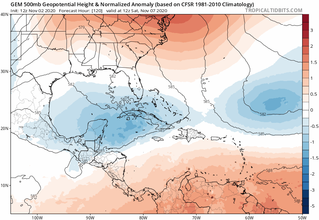
12Z CMC with a similar 500MB pattern with ridge over Florida. Notice the storm really weakens in the Gulf assuming it even make it there. Dew points in the 40s and 50s now with lows in the low 50s for West-Central Florida. SSTs taking a big hit.
0 likes
-
SFLcane

- S2K Supporter
- Posts: 10281
- Age: 48
- Joined: Sat Jun 05, 2010 1:44 pm
- Location: Lake Worth Florida
Re: ATL: ETA - Models
tolakram wrote:No run should be thrown out. Long range models showing favorable conditions remain with the northern gulf coast seemingly the target for now, unless things change.
That's all there is to it. Past 5 days no one should be looking at finding low level circulations IMO and instead looking at broader patterns.
Actually from wxman57 earlier this morning unlikely to head into the GOM. See below
It appears that the jet stream will remain entrenched across the northern Gulf for weeks. I think Eta will regain hurricane strength in the NW Caribbean next Tuesday or so then meander for a while, waiting for the next trof to pick it up and carry it north and eastward.
0 likes
-
Loveweather12
- Tropical Storm

- Posts: 136
- Joined: Thu Aug 20, 2020 2:37 pm
Re: ATL: ETA - Models
TheStormExpert wrote::uarrow: Another Gulf Coast hit? Why am I not surprised. The ridge over Florida seems much more believable than a trough or weakness with the +NAO.
You weren’t saying that when the runs were going along with what you were saying was going to happen.
Like someone said earlier, we shouldn’t dismiss runs but instead monitor them & take each one seriously.
1 likes
-
TheStormExpert
Re: ATL: ETA - Models
SFLcane wrote:tolakram wrote:No run should be thrown out. Long range models showing favorable conditions remain with the northern gulf coast seemingly the target for now, unless things change.
That's all there is to it. Past 5 days no one should be looking at finding low level circulations IMO and instead looking at broader patterns.
Actually from wxman57 earlier this morning unlikely to head into the GOM. See below
It appears that the jet stream will remain entrenched across the northern Gulf for weeks. I think Eta will regain hurricane strength in the NW Caribbean next Tuesday or so then meander for a while, waiting for the next trof to pick it up and carry it north and eastward.
Unlikely to head into the GOM, really? The GOM has been the crossroads of MANY storms and hurricanes, not to mention he’s likely basing that off of one model run. Each model run seems to show a different solution. All we know is where this will be in 5 days and that’s emerging back into the Caribbean, from there it’s anyone’s guess.
0 likes
-
tolakram
- Admin
- Posts: 20179
- Age: 62
- Joined: Sun Aug 27, 2006 8:23 pm
- Location: Florence, KY (name is Mark)
Re: ATL: ETA - Models
SFLcane wrote:tolakram wrote:No run should be thrown out. Long range models showing favorable conditions remain with the northern gulf coast seemingly the target for now, unless things change.
That's all there is to it. Past 5 days no one should be looking at finding low level circulations IMO and instead looking at broader patterns.
Actually from wxman57 earlier this morning unlikely to head into the GOM. See below
It appears that the jet stream will remain entrenched across the northern Gulf for weeks. I think Eta will regain hurricane strength in the NW Caribbean next Tuesday or so then meander for a while, waiting for the next trof to pick it up and carry it north and eastward.
I'm not refuting that, I'm not a forecaster, I'm simply saying what the GFS is showing.
0 likes
M a r k
- - - - -
Join us in chat: Storm2K Chatroom Invite. Android and IOS apps also available.
The posts in this forum are NOT official forecasts and should not be used as such. Posts are NOT endorsed by any professional institution or STORM2K.org. For official information and forecasts, please refer to NHC and NWS products.
- - - - -
Join us in chat: Storm2K Chatroom Invite. Android and IOS apps also available.
The posts in this forum are NOT official forecasts and should not be used as such. Posts are NOT endorsed by any professional institution or STORM2K.org. For official information and forecasts, please refer to NHC and NWS products.

-
toad strangler

- S2K Supporter
- Posts: 4546
- Joined: Sun Jul 28, 2013 3:09 pm
- Location: Earth
- Contact:
Re: ATL: ETA - Models
TheStormExpert wrote:SFLcane wrote:tolakram wrote:No run should be thrown out. Long range models showing favorable conditions remain with the northern gulf coast seemingly the target for now, unless things change.
That's all there is to it. Past 5 days no one should be looking at finding low level circulations IMO and instead looking at broader patterns.
Actually from wxman57 earlier this morning unlikely to head into the GOM. See below
It appears that the jet stream will remain entrenched across the northern Gulf for weeks. I think Eta will regain hurricane strength in the NW Caribbean next Tuesday or so then meander for a while, waiting for the next trof to pick it up and carry it north and eastward.
Unlikely to head into the GOM, really? The GOM has been the crossroads of MANY storms and hurricanes, not to mention he’s likely basing that off of one model run. Each model run seems to show a different solution. All we know is where this will be in 5 days and that’s emerging back into the Caribbean, from there it’s anyone’s guess.
Pro's don't base anything off one model run.
3 likes
My Weather Station
https://www.wunderground.com/dashboard/pws/KFLPORTS603
https://www.wunderground.com/dashboard/pws/KFLPORTS603
-
chris_fit

- Category 5

- Posts: 3261
- Age: 43
- Joined: Wed Sep 10, 2003 11:58 pm
- Location: Tampa Bay Area, FL
Re: ATL: ETA - Models
Majority of 12Z GFS Ens members shoot this into the W FL Coast, pretty much entire coast has impact according to these solutions.
The Deterministic GFS run is a W outlier

The Deterministic GFS run is a W outlier
3 likes
-
ColdMiser123

- Professional-Met

- Posts: 905
- Age: 29
- Joined: Mon Sep 26, 2016 3:26 pm
- Location: Northeast US
Re: ATL: ETA - Models
Quite a few GEFS members threaten Florida in the extended range, a truly remarkable 500 mb ridge over the east for early-mid November. At the very least, this should cause Eta to bend to the left after reemerging into the Gulf of Honduras.
Last edited by ColdMiser123 on Mon Nov 02, 2020 12:45 pm, edited 1 time in total.
2 likes
B.S., M.S., Meteorology & Atmospheric Science
-
SouthFLTropics

- Category 5
- Posts: 4258
- Age: 50
- Joined: Thu Aug 14, 2003 8:04 am
- Location: Port St. Lucie, Florida
Re: ATL: ETA - Models
I stated previously on another topic here on S2K that, IN MY OPINION to get a significant storm to hit CONUS in November, you would need it to be at a certain sweet spot in the NW Caribbean. That sweet spot would be anywhere from Cancun/Cozumel to the Isle of Pines in Cuba, with the Yucatan Channel being the optimal place to hang out and wait for a trough to send something for a CONUS strike. Eventual impact area would depend on the orientation of the trough. Bottom line, when and IF Eta emerges, where it decides to spend its time in the Caribbean and redevelop will be key to any CONUS impacts. If it sets up east of the Isle of Pines, my gut tells me it would get taken out to sea. Right now, the models appear to be setting it up in the NW Caribbean, possibly in that "Sweet spot". A storm impact further north on CONUS would weaken on approach due to shear and dry air. South Florida would be at most risk to experience a higher end storm.
3 likes
Fourth Generation Florida Native
Personal Storm History: David 79, Andrew 92, Erin 95, Floyd 99, Irene 99, Frances 04, Jeanne 04, Wilma 05, Matthew 16, Irma 17, Ian 22, Nicole 22, Milton 24
Personal Storm History: David 79, Andrew 92, Erin 95, Floyd 99, Irene 99, Frances 04, Jeanne 04, Wilma 05, Matthew 16, Irma 17, Ian 22, Nicole 22, Milton 24
-
otowntiger
- Category 5
- Posts: 1932
- Joined: Tue Aug 31, 2004 7:06 pm
Re: ATL: ETA - Models
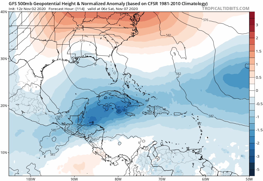
gatorcane wrote:12Z GFS builds a ridge over Florida:
https://i.postimg.cc/6qS7ZNrM/gfs-z500a-Norm-watl-fh114-228.gif
Yep- that been a very regularly appearing feature this season- off and on, but has shown up in a very timely manner for the sake of the peninsula. Could start calling it ‘the Florida high’ much like the Bermuda high.
0 likes
-
supercane4867
- Category 5
- Posts: 4966
- Joined: Wed Nov 14, 2012 10:43 am
Re: ATL: ETA - Models
12z HWRF makes a cyclonic loop on the Nicaraguan coast...Would be apocalyptic for the landfall region
2 likes
-
SouthFLTropics
- Category 5
- Posts: 4258
- Age: 50
- Joined: Thu Aug 14, 2003 8:04 am
- Location: Port St. Lucie, Florida
Re: ATL: ETA - Models
12z Euro running... Lets see (HOPE) that it abandons it's crazy 930mb run in the Yucatan Channel that it had at 00z.
0 likes
Fourth Generation Florida Native
Personal Storm History: David 79, Andrew 92, Erin 95, Floyd 99, Irene 99, Frances 04, Jeanne 04, Wilma 05, Matthew 16, Irma 17, Ian 22, Nicole 22, Milton 24
Personal Storm History: David 79, Andrew 92, Erin 95, Floyd 99, Irene 99, Frances 04, Jeanne 04, Wilma 05, Matthew 16, Irma 17, Ian 22, Nicole 22, Milton 24
-
fox13weather
- Professional-Met
- Posts: 161
- Joined: Tue Sep 20, 2005 7:49 pm
Re: ATL: ETA - Models
chris_fit wrote:Majority of 12Z GFS Ens members shoot this into the W FL Coast, pretty much entire coast has impact according to these solutions.
The Deterministic GFS run is a W outlier
https://i.imgur.com/XColqYH.png
IT IS HOUR 270. The value of an 11 day forecast is basically none. "pretty much the entire coast has impact". What??? Could it happen? Sure, only because it has to go somewhere, but the value of a 270 forecast is pretty much zero.
1 likes
-
fox13weather
- Professional-Met
- Posts: 161
- Joined: Tue Sep 20, 2005 7:49 pm
Re: ATL: ETA - Models
SouthFLTropics wrote:I stated previously on another topic here on S2K that, IN MY OPINION to get a significant storm to hit CONUS in November, you would need it to be at a certain sweet spot in the NW Caribbean. That sweet spot would be anywhere from Cancun/Cozumel to the Isle of Pines in Cuba, with the Yucatan Channel being the optimal place to hang out and wait for a trough to send something for a CONUS strike. Eventual impact area would depend on the orientation of the trough. Bottom line, when and IF Eta emerges, where it decides to spend its time in the Caribbean and redevelop will be key to any CONUS impacts. If it sets up east of the Isle of Pines, my gut tells me it would get taken out to sea. Right now, the models appear to be setting it up in the NW Caribbean, possibly in that "Sweet spot". A storm impact further north on CONUS would weaken on approach due to shear and dry air. South Florida would be at most risk to experience a higher end storm.
Hurricane Kate would like a word with you.
https://www.wpc.ncep.noaa.gov/tropical/ ... e1985.html
3 likes
-
chris_fit
- Category 5
- Posts: 3261
- Age: 43
- Joined: Wed Sep 10, 2003 11:58 pm
- Location: Tampa Bay Area, FL
Re: ATL: ETA - Models
fox13weather wrote:chris_fit wrote:Majority of 12Z GFS Ens members shoot this into the W FL Coast, pretty much entire coast has impact according to these solutions.
The Deterministic GFS run is a W outlier
https://i.imgur.com/XColqYH.png
IT IS HOUR 270. The value of an 11 day forecast is basically none. "pretty much the entire coast has impact". What??? Could it happen? Sure, only because it has to go somewhere, but the value of a 270 forecast is pretty much zero.
Totally Agree 100%! Meant to say that the 12 GFS Ens show possible impact anywhere on the W Coast of FL - could have worded that better.
0 likes
-
SouthFLTropics
- Category 5
- Posts: 4258
- Age: 50
- Joined: Thu Aug 14, 2003 8:04 am
- Location: Port St. Lucie, Florida
Re: ATL: ETA - Models
fox13weather wrote:SouthFLTropics wrote:I stated previously on another topic here on S2K that, IN MY OPINION to get a significant storm to hit CONUS in November, you would need it to be at a certain sweet spot in the NW Caribbean. That sweet spot would be anywhere from Cancun/Cozumel to the Isle of Pines in Cuba, with the Yucatan Channel being the optimal place to hang out and wait for a trough to send something for a CONUS strike. Eventual impact area would depend on the orientation of the trough. Bottom line, when and IF Eta emerges, where it decides to spend its time in the Caribbean and redevelop will be key to any CONUS impacts. If it sets up east of the Isle of Pines, my gut tells me it would get taken out to sea. Right now, the models appear to be setting it up in the NW Caribbean, possibly in that "Sweet spot". A storm impact further north on CONUS would weaken on approach due to shear and dry air. South Florida would be at most risk to experience a higher end storm.
Hurricane Kate would like a word with you.
https://www.wpc.ncep.noaa.gov/tropical/ ... e1985.html
Of course, there are exceptions to every situation. But the fact that hasn't happened again in 35 years goes to show how rare that is.
0 likes
Fourth Generation Florida Native
Personal Storm History: David 79, Andrew 92, Erin 95, Floyd 99, Irene 99, Frances 04, Jeanne 04, Wilma 05, Matthew 16, Irma 17, Ian 22, Nicole 22, Milton 24
Personal Storm History: David 79, Andrew 92, Erin 95, Floyd 99, Irene 99, Frances 04, Jeanne 04, Wilma 05, Matthew 16, Irma 17, Ian 22, Nicole 22, Milton 24
-
Hypercane_Kyle

- Category 5
- Posts: 3465
- Joined: Sat Mar 07, 2015 7:58 pm
- Location: Cape Canaveral, FL
Re: ATL: ETA - Models
Gonna be tough for anything to get into the Gulf with a good upper-level environment this time of year. Normally, destructive shear awaits anything in the Gulf.
0 likes
My posts are my own personal opinion, defer to the National Hurricane Center (NHC) and other NOAA products for decision making during hurricane season.
-
Loveweather12
- Tropical Storm
- Posts: 136
- Joined: Thu Aug 20, 2020 2:37 pm
Re: ATL: ETA - Models
otowntiger wrote:gatorcane wrote:12Z GFS builds a ridge over Florida:
https://i.postimg.cc/6qS7ZNrM/gfs-z500a-Norm-watl-fh114-228.gif
Yep- that been a very regularly appearing feature this season- off and on, but has shown up in a very timely manner for the sake of the peninsula. Could start calling it ‘the Florida high’ much like the Bermuda high.
Doesn’t mean that’s gonna happen & def doesn’t mean to right off any path so we need to keep watching. Thank you
0 likes
Who is online
Users browsing this forum: No registered users and 106 guests