ATL: ZETA - Post-Tropical - Discussion
Moderator: S2k Moderators

Re: ATL: ZETA - Tropical Storm - Discussion
May be a right sided storm in gulf, most weather ends up over Fl w. coast.
1 likes
Re: ATL: ZETA - Tropical Storm - Discussion
I apologize if someone has already addressed this...but do yall think the intensity forecast is conservative(or too liberal) at this time?....Zeta looks very healthy this morning....
Last edited by underthwx on Sun Oct 25, 2020 11:03 am, edited 1 time in total.
3 likes
-
ElectricStorm

- Category 5

- Posts: 5144
- Age: 25
- Joined: Tue Aug 13, 2019 11:23 pm
- Location: Norman, OK
Re: ATL: ZETA - Tropical Storm - Discussion
underthwx wrote:I apologize if someone has already addressed this...but do yall think the intensity forecast is conservative at this time?....Zeta looks very healthy this morning....
I wouldn't say very healthy at all actually. It's struggling with shear right now... But if the shear let's up and it gets stacked... Watch out...
2 likes
B.S Meteorology, University of Oklahoma '25
Please refer to the NHC, NWS, or SPC for official information.
Please refer to the NHC, NWS, or SPC for official information.

Re: ATL: ZETA - Tropical Storm - Discussion
You see the SW shift over the past few days:
7 likes
The following post is NOT an official forecast and should not be used as such. It is just the opinion of the poster and may or may not be backed by sound meteorological data. It is NOT endorsed by any professional institution including storm2k.org For Official Information please refer to the NHC and NWS products.

Re: ATL: ZETA - Tropical Storm - Discussion
We really need recon or buoy data to have a better idea of where the center actually is; looking at satellite loops Zeta'a convective mass hasn't moved at all for the past 12 hours. I'd bet either Zeta is decoupling or the center is shifting/reforming closer to the convection
0 likes
-
Hurricaneman

- Category 5
- Posts: 7404
- Age: 45
- Joined: Tue Aug 31, 2004 3:24 pm
- Location: central florida
Re: ATL: ZETA - Tropical Storm - Discussion
blp wrote:You see the SW shift over the past few days:
https://uploads.disquscdn.com/images/8ac7451db3295f42c1dcdc877cbc4ecb0cb441867b1882b8d1baaa3aef129371.png
Looks to me that the LLC may be closer to the 6Z Position if not a tad east of that but there's at least 40 miles between the MLC and LLC which is a sign of northerly shear, but thats looking at visible and this still has a way to go to become potent like the intensity models show
0 likes

Re: ATL: ZETA - Tropical Storm - Discussion
Weather Dude wrote:underthwx wrote:I apologize if someone has already addressed this...but do yall think the intensity forecast is conservative at this time?....Zeta looks very healthy this morning....
I wouldn't say very healthy at all actually. It's struggling with shear right now... But if the shear let's up and it gets stacked... Watch out...
I wouldn’t really call it struggling that much. It’s...eh. Getting there, still a little offset, and has a very high ceiling if shear relaxes — but there’s an incredible amount of uncertainty with this.
My guess is that we have a stacking storm by late afternoon/early evening, resulting in RI on Monday.
2 likes
Irene '11 Sandy '12 Hermine '16 5/15/2018 Derecho Fay '20 Isaias '20 Elsa '21 Henri '21 Ida '21
I am only a meteorology enthusiast who knows a decent amount about tropical cyclones. Look to the professional mets, the NHC, or your local weather office for the best information.
I am only a meteorology enthusiast who knows a decent amount about tropical cyclones. Look to the professional mets, the NHC, or your local weather office for the best information.
-
cp79
Re: ATL: ZETA - Tropical Storm - Discussion
crimi481 wrote:May be a right sided storm in gulf, most weather ends up over Fl w. coast.
I don’t know about that. HP is going to block a lot of the moisture from heading towards them. Now if it slows and waits more for the trough, then I agree more. Right now the longer it sits stationary, the more likely it is to head more East in time. This thing is forecast to exit the Yucatán in 48 hours. If it’s still in the Caribbean by Tuesday morning, then Florida becomes a concern.
3 likes
-
skyline385

- Category 5
- Posts: 2728
- Age: 35
- Joined: Wed Aug 26, 2020 11:15 pm
- Location: Houston TX
-
wxman57

- Moderator-Pro Met

- Posts: 23172
- Age: 68
- Joined: Sat Jun 21, 2003 8:06 pm
- Location: Houston, TX (southwest)
Re: ATL: ZETA - Tropical Storm - Discussion
underthwx wrote:I apologize if someone has already addressed this...but do yall think the intensity forecast is conservative at this time?....Zeta looks very healthy this morning....
I'm wondering if it will really reach hurricane intensity. Looks very poorly-organized this morning, considering the center is likely north of the heavy squalls. Would be nice to get a plane in there. There is lots of dry air in the Gulf, and wind shear will only increase on Wednesday as it approaches SE LA. Agree on the half-storm near landfall. Not much west of the center. I have it moving at 20-25 mph at landfall on the MS coast 7pm Wed and at close to 45 mph between 9pm Wed and 9am Thu when it reaches the Carolinas.
5 likes
Re: ATL: ZETA - Tropical Storm - Discussion
wxman57 wrote:underthwx wrote:I apologize if someone has already addressed this...but do yall think the intensity forecast is conservative at this time?....Zeta looks very healthy this morning....
I'm wondering if it will really reach hurricane intensity. Looks very poorly-organized this morning, considering the center is likely north of the heavy squalls. Would be nice to get a plane in there. There is lots of dry air in the Gulf, and wind shear will only increase on Wednesday as it approaches SE LA. Agree on the half-storm near landfall. Not much west of the center. I have it moving at 20-25 mph at landfall on the MS coast 7pm Wed and at close to 45 mph between 9pm Wed and 9am Thu when it reaches the Carolinas.
Thankyou for your reply, and good morning to you and all of you!.....that is encouraging to hear this information, I had heard that there was abundant dry air in the Gulf....so hopefully, Zeta will not be a strong system....
0 likes
-
skyline385
- Category 5
- Posts: 2728
- Age: 35
- Joined: Wed Aug 26, 2020 11:15 pm
- Location: Houston TX
Re: ATL: ZETA - Tropical Storm - Discussion
underthwx wrote:wxman57 wrote:underthwx wrote:I apologize if someone has already addressed this...but do yall think the intensity forecast is conservative at this time?....Zeta looks very healthy this morning....
I'm wondering if it will really reach hurricane intensity. Looks very poorly-organized this morning, considering the center is likely north of the heavy squalls. Would be nice to get a plane in there. There is lots of dry air in the Gulf, and wind shear will only increase on Wednesday as it approaches SE LA. Agree on the half-storm near landfall. Not much west of the center. I have it moving at 20-25 mph at landfall on the MS coast 7pm Wed and at close to 45 mph between 9pm Wed and 9am Thu when it reaches the Carolinas.
Thankyou for your reply, and good morning to you and all of you!.....that is encouraging to hear this information, I had heard that there was abundant dry air in the Gulf....so hopefully, Zeta will not be a strong system....
You can check dry air by looking at the humidity plots on various models.

1 likes
-
wxman57
- Moderator-Pro Met
- Posts: 23172
- Age: 68
- Joined: Sat Jun 21, 2003 8:06 pm
- Location: Houston, TX (southwest)
Re: ATL: ZETA - Tropical Storm - Discussion
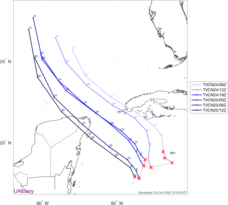
One thing to take note of concerning the NHC track. There's a 24-hr gap between when it's well offshore Wednesday and well Inland Thursday. The map draws a straight line between the points, clipping the mouth of the MS. However, that track is actually very near New Orleans Wednesday afternoon, 40-50 miles west of where it appears to be. Cutting corners like that makes it look like the center crosses the MS coast near the AL border, when it's actually near the LA border.
Here, I plotted the NHC track (dark red) vs. consensus (TVCN), the model they are following. You can see that the NHC only having points 24 hrs apart near landfall makes a BIG difference in the track near the coast.

Here, I plotted the NHC track (dark red) vs. consensus (TVCN), the model they are following. You can see that the NHC only having points 24 hrs apart near landfall makes a BIG difference in the track near the coast.
4 likes
-
skyline385
- Category 5
- Posts: 2728
- Age: 35
- Joined: Wed Aug 26, 2020 11:15 pm
- Location: Houston TX
Re: ATL: ZETA - Tropical Storm - Discussion
12Z GFS seems to be agreeing with ICON with a Cat 1 landfall
0 likes
Re: ATL: ZETA - Tropical Storm - Discussion
Zeta doesn’t look that bad (it has very good outflow in some quadrants and the LLC isn’t displaced very far), but now there are a wide range of possibilities on the table. It’s possible this shear will continue for longer and push dry air into the core, permanently crippling Zeta and resulting in a higher-end TS at best. It’s also possible this shear is quite temporary and a large blow-up of convection causes the LLC and MLC to quickly snap together like with Sally, and it RIs into a powerful major. It might remain weak and plow into Belize, or it can get strong enough to be dragged further north into the Yucatán channel. Who knows at this point.
Today seems to be Zeta’s “getting ready” day, and whatever state it’s in by the end of the day will determine its intensification tomorrow and its future track.
Today seems to be Zeta’s “getting ready” day, and whatever state it’s in by the end of the day will determine its intensification tomorrow and its future track.
9 likes
Irene '11 Sandy '12 Hermine '16 5/15/2018 Derecho Fay '20 Isaias '20 Elsa '21 Henri '21 Ida '21
I am only a meteorology enthusiast who knows a decent amount about tropical cyclones. Look to the professional mets, the NHC, or your local weather office for the best information.
I am only a meteorology enthusiast who knows a decent amount about tropical cyclones. Look to the professional mets, the NHC, or your local weather office for the best information.
-
SunnyThoughts
- Category 5
- Posts: 2263
- Joined: Wed Jul 09, 2003 12:42 pm
- Location: Pensacola, Florida
Re: ATL: ZETA - Tropical Storm - Discussion
Stores getting busy here in Pensacola area. People buying ice...etc. Good luck everybody. Sure hope this is the LAST hurrah of hurricane season this year...enough is enough. Hopefully just a TS at landfall.
1 likes
Re: ATL: ZETA - Tropical Storm - Discussion
aspen wrote:Zeta doesn’t look that bad (it has very good outflow in some quadrants and the LLC isn’t displaced very far), but now there are a wide range of possibilities on the table. It’s possible this shear will continue for longer and push dry air into the core, permanently crippling Zeta and resulting in a higher-end TS at best. It’s also possible this shear is quite temporary and a large blow-up of convection causes the LLC and MLC to quickly snap together like with Sally, and it RIs into a powerful major. It might remain weak and plow into Belize, or it can get strong enough to be dragged further north into the Yucatán channel. Who knows at this point.
Today seems to be Zeta’s “getting ready” day, and whatever state it’s in by the end of the day will determine its intensification tomorrow and its future track.
Looking at satellite...as I posted earlier....Zeta appears to be holding its own...I've seen worse looking systems.....and as Aspen has pointed out....there are many factors in play, concerning track, strength, etc....Zeta just may have a few surprises in store.....it's been that kind of a hurricane season...
2 likes
-
wxman57
- Moderator-Pro Met
- Posts: 23172
- Age: 68
- Joined: Sat Jun 21, 2003 8:06 pm
- Location: Houston, TX (southwest)
Re: ATL: ZETA - Tropical Storm - Discussion
skyline385 wrote:12Z GFS seems to be agreeing with ICON with a Cat 1 landfall
I'm skeptical of a couple of things. First, the NHC has it becoming a hurricane as it exits the Yucatan Peninsula. I'd think that would be unlikely. GFS and ICON keep it a TS until 12 hrs prior to landfall Wednesday, when the NHC indicates weakening. I think both the GFS and ICON are having difficulty with the strong cold front that will be moving into the NW Gulf to its west Wednesday. They may be indicating some type of baroclinic deepening (not tropical) as the front approaches. Relative wind shear may drop a little as it makes the N-NNE turn on Wednesday, but there will still be the dry air and decreasing oceanic heat content. Just doesn't look favorable for a hurricane in the Gulf.
5 likes
Re: ATL: ZETA - Tropical Storm - Discussion
According to ADT analysis the raw T numbers are up to 3.2. They've been slowly climbing all morning, from around 2 last night
0 likes
Who is online
Users browsing this forum: No registered users and 94 guests